You can help expand this article with text translated from the corresponding article in German. (February 2009) Click [show] for important translation instructions.
|
Sigmaringendorf (Swabian: Semmerengadorf) is a small town in the district of Sigmaringen in Baden-Württemberg in Germany. In Sigmaringendorf the small river Lauchert flows into the Danube. There is an open-air-theatre in Sigmaringendorf, it's called Waldbühne Sigmaringendorf.
Sigmaringendorf | |
|---|---|
 Town hall | |
 Coat of arms | |
Location of Sigmaringendorf within Sigmaringen district 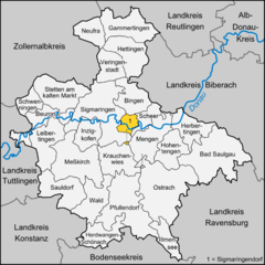 | |
 Sigmaringendorf  Sigmaringendorf | |
| Coordinates: 48°4′0″N 9°15′51″E / 48.06667°N 9.26417°E | |
| Country | Germany |
| State | Baden-Württemberg |
| Admin. region | Tübingen |
| District | Sigmaringen |
| Government | |
| • Mayor (2017–25) | Philip Schwaiger[1] (CDU) |
| Area | |
| • Total | 12.47 km2 (4.81 sq mi) |
| Elevation | 569 m (1,867 ft) |
| Population (2022-12-31)[2] | |
| • Total | 3,735 |
| • Density | 300/km2 (780/sq mi) |
| Time zone | UTC+01:00 (CET) |
| • Summer (DST) | UTC+02:00 (CEST) |
| Postal codes | 72517 |
| Dialling codes | 07571 |
| Vehicle registration | SIG |
| Website | www.sigmaringendorf.de |
Mayors edit
Since September 2018 Phillip Schwaiger is the mayor of Sigmaringendorf.
- Alois Henne (1980-2018)
- Wilhelm Siebenrock (1946–1953)
- Alois Maucher (1953–1980)
References edit
- ^ Aktuelle Wahlergebnisse, Staatsanzeiger, accessed 15 September 2021.
- ^ "Bevölkerung nach Nationalität und Geschlecht am 31. Dezember 2022" [Population by nationality and sex as of December 31, 2022] (CSV) (in German). Statistisches Landesamt Baden-Württemberg. June 2023.
This Sigmaringen district location article is a stub. You can help Wikipedia by expanding it. |