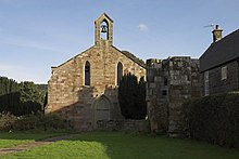
Rosedale Priory was a priory in Rosedale Abbey, North Yorkshire, England that was founded c. 1150–1199. By the time the priory was suppressed in 1535, it had one prioress and eight nuns.[1] The religious house in Rosedale was a priory and not an abbey, despite the village being given the name Rosedale Abbey, and it is unclear why this came about.[2]

The priory was founded during the reign of Henry II and finished during the reign of Richard the Lionheart. The land was donated by Robert de Stuteville, so that nuns from the Benedictine order could worship and farm the surrounding land.[3]
After suppression during the reign of King Henry VIII, the priory was abandoned, though it is thought that most of the stones were re-used in the construction of the village buildings including the adjacent church of St Mary and St Lawrence.[4] The only ruin left standing is a 13th-century turret which rises to 20 feet (6.1 m) high and is just to the west of the present church.[5] The turret was grade II listed in 1953.[6]
References edit
- ^ "Houses of Cistercians nuns: Rosedale Priory | British History Online". www.british-history.ac.uk. Retrieved 27 November 2018.
- ^ Walker, Peter (2 October 2016). "Where is the abbey in Rosedale?". Gazette & Herald. Retrieved 27 November 2018.
- ^ Eastmead, William (1824). Historia Rievallensis, containing the history of Kirkby Moorside[sic], and an account of the most important places in its vicinity; together with brief notices of the more remote or less important ones. To which is prefixed a dissertation on the animal remains and other curious phenomena in the recently discovered cave at Kirkdale. London: Baldwin, Cradock & Joy. p. 306. OCLC 770849.
- ^ "About us - St Mary & St Lawrence -A Church Near You". www.achurchnearyou.com. Retrieved 27 November 2018.
- ^ Berry, Chris (1 July 2005). "A toast to the nuns of Rosedale". The Yorkshire Post. Retrieved 27 November 2018.
- ^ Historic England. "Priory Remains (Grade II) (1315706)". National Heritage List for England. Retrieved 27 November 2018.
54°21′13″N 0°53′17″W / 54.3537°N 0.8880°W