Route 210 is a provincial highway located in the Estrie region of Quebec. The 40.9 km (25.4 mi) highway runs from west to east from the Eaton area of Cookshire-Eaton at the junction of Route 108 to Chartierville at the junction of Route 257, via the village of Sawyerville. Between Eaton and Sawyerville, it overlaps Route 253 for slightly more than 4 km (2.5 mi).
Route 210 | ||||
|---|---|---|---|---|
 | ||||
| Route information | ||||
| Maintained by Transports Québec | ||||
| Length | 40.9 km[1] (25.4 mi) | |||
| Major junctions | ||||
| West end | ||||
| East end | ||||
| Location | ||||
| Country | Canada | |||
| Province | Quebec | |||
| Highway system | ||||
| ||||

Approximately 15 km (9.3 mi) of the easternmost section of Route 210 is unpaved, other than the final 450 metres (0.28 mi) approaching the terminus at Route 257.
Municipalities along Route 210 edit
-
 Route 210 east of Eaton Corner.
 -
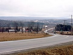
 Route 253 and 210 in Sawyerville.
 -
 Route 210 nearing Saint-Mathias-de-Bonneterre.
 -
 Route 210 is unpaved between Saint-Mathias and Chartierville.
 -
 Eastern terminus of Route 210 in Chartierville.


Major intersections edit
The entire route is in Le Haut-Saint-François RCM.
| Location | km | mi | Destinations | Notes | |
|---|---|---|---|---|---|
| Cookshire-Eaton | 0 | 0.0 | Western terminus | ||
| 5.2 | 3.2 | Begin/end concurrency with Route 253 | |||
| 9.8 | 6.1 | Begin/end concurrency with Route 253 | |||
| Chartierville | 40.9 | 25.4 | Eastern terminus | ||
| 1.000 mi = 1.609 km; 1.000 km = 0.621 mi | |||||
See also edit
References edit
- ^ Ministère des transports, "Distances routières", page 81, Les Publications du Québec, 2005
External links edit
- Official Transport Quebec Road Map
- Route 210 on Google Maps
This Quebec road, road transport or highway-related article is a stub. You can help Wikipedia by expanding it. |