Odiliapeel (Brabantian: De Piejel) is a village in the Netherlands. It is situated in the northeast corner of the province of North Brabant, south of Volkel Air Base. It used to be part of the municipality of Uden, but merged into the municipality of Maashorst in 2022.
Odiliapeel | |
|---|---|
 Kruisvindingskerk | |
 Odiliapeel Location in the province of North Brabant in the Netherlands  Odiliapeel Odiliapeel (Netherlands) | |
| Coordinates: 51°38′40″N 5°42′20″E / 51.64444°N 5.70556°E | |
| Country | Netherlands |
| Province | North Brabant |
| Municipality | Maashorst |
| Established | 1921 |
| Area | |
| • Total | 14.38 km2 (5.55 sq mi) |
| Elevation | 22 m (72 ft) |
| Population (2021)[1] | |
| • Total | 2,045 |
| • Density | 140/km2 (370/sq mi) |
| Time zone | UTC+1 (CET) |
| • Summer (DST) | UTC+2 (CEST) |
| Postal code | 5409[1] |
| Dialing code | 0413 |
Odiliapeel was founded in 1921 as a heath excavation settlement. On 5 May 1930, it was officially named Odiliapeel, and is a combination of Odile of Alsace and the region Peel.[3] The initial excavation of the area started in 1908,[4] however a government subsidy plan led to the systematic exploration of the area. The village was designed by Heidemij (nowadays: Arcadis).[5]
The Catholic Kruisvindingskerk was built between 1958 and 1959 as an aisleless church and a massive tower attached to the side of the church.[4]
Gallery edit
-
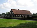 Farm in Odiliapeel
 -
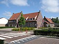 Community house
 -
 Farm in Odiliapeel


References edit
- ^ a b c "Kerncijfers wijken en buurten 2021". Central Bureau of Statistics. Retrieved 17 April 2022.
- ^ "Postcodetool for 5409AA". Actueel Hoogtebestand Nederland (in Dutch). Het Waterschapshuis. Retrieved 17 April 2022.
- ^ "Achterground". Odiliapeel (in Dutch). Retrieved 17 April 2022.
- ^ a b Chris Kolman & Ronald Stenvert (1997). Uden (in Dutch). Zwolle: Waanders. p. 313. ISBN 90 400 9945 6. Retrieved 16 April 2022.
- ^ "Odiliapeel". Plaatsengids (in Dutch). Retrieved 17 April 2022.
External links edit
- Official site (in Dutch)
This North Brabant location article is a stub. You can help Wikipedia by expanding it. |