Route 17, commonly known as the Stewart Highway, is 148 kilometres (92 mi) long and runs from the Canada–US border in Saint-Leonard to Route 11 in Glencoe near Campbellton. Saint-Quentin and Kedgwick are other towns along the route. With the exception of those towns, the highway runs almost entirely through sparsely populated forest land. It is the only highway connecting northwestern New Brunswick with the province's north shore. It is named in honour of David A. Stewart.
Route 17 | ||||
|---|---|---|---|---|
| Stewart Highway | ||||
| Route information | ||||
| Maintained by New Brunswick Department of Transportation | ||||
| Length | 158.8 km[1] (98.7 mi) | |||
| Existed | 1920s–present | |||
| Major junctions | ||||
| North end | ||||
| South end | Canada–US border at Saint-Leonard | |||
| Location | ||||
| Country | Canada | |||
| Province | New Brunswick | |||
| Major cities | Kedgwick, Saint-Quentin, Saint-Leonard | |||
| Highway system | ||||
| ||||


History edit
Over several decades, Route 17 has received several upgrades, and new sections of road built, to improve safety. These upgrades have been designed to meet present-day standards, including flatter grades, creation of more passing lanes, upgrades to guard rail requirements and increased shoulder widths. Some examples of these, have been the new alignments of the highway north of Saint-Leonard, or the bypassing of Dawsonville, west of Campbellton.[2][3]
Route description edit
Route 17's northern terminus is at a T intersection with Route 11 in Glencoe (Route 17 is a continuation of the Route 11 direct right of way.) It runs southwesterly from there, passing through the communities of Glen Levit, and Squaw Cap. Between the two communities, is a new section of highway, opened in the early 2000s bypassing Dawsonville, and adhering to modern highway standards.
After roughly 19 kilometres, Route 17 crosses the Upsalquitch River, and passes through Robinsonville, before climbing Upsalquitch Hill. With an 11% grade, it is the steepest arterial highway grade in the province.[4]
Atop of the hill, the road passes through Glenwood. Southwest of Glenwood, the highway descends and then climbs back up Adams Gulch, while passing through the community of the same name. After running west in the wilderness for almost 10 kilometres, Route 17 passes through Menneval, then Saint-Jean-Baptiste, before heading through Kedgwick, where there is a sharp 90 degree turn. Once past Kedgwick, Route 17 turns south, due for the town of Saint-Quentin.
After Saint-Quentin, the highway heads in a southwesterly manner once more and heads through wilderness, with only J.D. Irving's Sawmill in Veneer, in that stretch of woods. Approximately 50 kilometres later, Route 17 hits civilization in Saint-Leonard-Parent, nearing its southern terminus. Roughly 10 kilometres to the southwest, the highway reaches the town of Saint-Leonard. Passing under the Trans-Canada Highway, Route 17 continues to the Canada–United States border, where it reaches it southern terminus.[5]
The speed limit varies throughout the route, from 50 km/h in Kedgwick and Saint-Quentin, to 90 km/h, on many rural and uninhabited stretches.[6][7][8]
Major intersections edit
| County | Location | km[1] | mi | Destinations | Notes | |||
|---|---|---|---|---|---|---|---|---|
| Canada–United States border | Van Buren - St. Leonard Border Crossing | 0.0 | 0.0 | Continues into Maine | ||||
| Saint Leonard–Van Buren Bridge crosses the Saint John River | ||||||||
| Madawaska | Saint-Léonard | 0.6 | 0.37 | |||||
| 1.6 | 0.99 | Route 2 exit 58 | ||||||
| | 12.2 | 7.6 | ||||||
| Victoria |
No major junctions | |||||||
| Restigouche | | 71.7 | 44.6 | |||||
| Saint-Quentin | 74.8 | 46.5 | ||||||
| | 89.6 | 55.7 | ||||||
| Kedgwick | 92.3 | 57.4 | ||||||
| Glencoe | 157.4 | 97.8 | ||||||
| | 158.8 | 98.7 | Roadway continues as Route 11 south | |||||
| 1.000 mi = 1.609 km; 1.000 km = 0.621 mi | ||||||||
Gallery edit
-
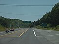
 Route 17 in Whites Brook
 -
 Route 11's junction with route 17 in Tide Head.
 -
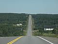
 Route 17 in Glencoe


See also edit
References edit
- ^ a b Google (January 20, 2020). "New Brunswick Route 17" (Map). Google Maps. Google. Retrieved January 20, 2020.
- ^ "Route 17 Upgrades Violette Brook to Magee Road".
- ^ "Route 17 Upgrades North of Mud Brook to Hammond Gate Road Area". 3 October 2011.
- ^ "NB-17 Google Maps Street View". Google Maps. August 2018.
- ^ "Google Maps".
- ^ "Google Maps | Street View - Route 17 Kedgwick, New Brunswick". Google Maps. August 2018. Retrieved May 3, 2019.
- ^ "Google Maps | Street View - Route 17 Saint-Quentin, New Brunswick". Google Maps. August 2018. Retrieved May 3, 2019.
- ^ "Google Maps | Street View - Route 17 Glen Levit, New Brunswick". Google Maps. August 2018. Retrieved May 3, 2019.