Mount Weart is a 2,835-metre (9,301-foot) triple-summit mountain located in the Garibaldi Ranges of the Coast Mountains, in northwestern Garibaldi Provincial Park of southwestern British Columbia, Canada. It is situated 14 km (9 mi) northeast of Whistler, and its nearest higher peak is Wedge Mountain, 3.7 km (2 mi) to the south, which is the only peak within the park higher than Weart.[2] The Armchair Glacier rests below the west aspect of the summit, and the massive Weart Glacier spans the northern and eastern aspects of the mountain. Precipitation runoff from the peak and meltwater from the glaciers drains into Wedgemount Lake and tributaries of the Lillooet River.
| Mount Weart | |
|---|---|
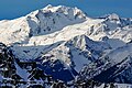
 Mount Weart, south summit featured, the highest of the three peaks | |
| Highest point | |
| Elevation | 2,835 m (9,301 ft)[1] |
| Prominence | 365 m (1,198 ft)[1] |
| Parent peak | Wedge Mountain (2895 m)[1] |
| Listing | Mountains of British Columbia |
| Coordinates | 50°09′59″N 122°47′13″W / 50.16639°N 122.78694°W[1] |
| Geography | |
 Mount Weart Location in British Columbia  Mount Weart Mount Weart (Canada) | |
| Country | Canada |
| Province | British Columbia |
| District | New Westminster Land District |
| Protected area | Garibaldi Provincial Park |
| Parent range | Garibaldi Ranges Coast Ranges |
| Topo map | NTS 92J2 Whistler |
| Climbing | |
| First ascent | 1932 by B. Cook, P. Tait |
| Easiest route | Scrambling via southeast ridge |
History edit
Originally known by the mountaineering community as Armchair Mountain or The Armchair, the Garibaldi Park Board submitted the name "Mount Weart" in 1928, after their board's chairman at the time, John Walter Weart (1861–1941).[3] The mountain's toponym was officially adopted on September 2, 1930, by the Geographical Names Board of Canada.[4] The first ascent of the mountain was made in 1932 by B. Cook and P. Tait.[1]
Climate edit
Based on the Köppen climate classification, Mount Weart is located in the marine west coast climate zone of western North America.[5] Most weather fronts originate in the Pacific Ocean, and travel east toward the Coast Mountains where they are forced upward by the range (orographic lift), causing them to drop their moisture in the form of rain or snowfall. As a result, the Coast Mountains experience high precipitation, especially during the winter months in the form of snowfall. Winter temperatures can drop below −20 °C with wind chill factors below −30 °C. The months July through September offer the most favorable weather for climbing Weart.
Climbing Routes edit
Established rock climbing routes on Mount Weart:[1]
See also edit
Gallery edit
-
 Mount Weart from Highway 99
 -
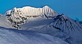
 Northeast aspect, viewed from Mt. Taylor
 -
 West face in winter
 -
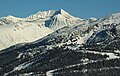 Mt. Weart from Whistler Mountain
 -
 Southeast Ridge, with "The Owls" to right


References edit
- ^ a b c d e f "Mount Weart". Bivouac.com. Retrieved 2019-11-12.
- ^ "Mount Weart, British Columbia". Peakbagger.com. Retrieved 2019-11-12.
- ^ "Mount Weart". BC Geographical Names. Retrieved 2019-11-12.
- ^ "Mount Weart". Geographical Names Data Base. Natural Resources Canada. Retrieved 2019-11-12.
- ^ Peel, M. C.; Finlayson, B. L.; McMahon, T. A. (2007). "Updated world map of the Köppen−Geiger climate classification". Hydrol. Earth Syst. Sci. 11. ISSN 1027-5606.
External links edit
- Weather: Mount Weart
- Climbing Mt. Weart: YouTube