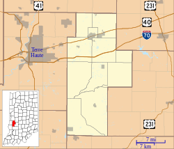
Meridian–Forest Historic District is a national historic district located at Brazil, Clay County, Indiana. The district encompasses 220 contributing buildings and 13 contributing structures in a predominantly residential section of Brazil. The district developed between about 1866 and 1940, and includes notable examples of Italianate, Romanesque Revival, and Queen Anne style architecture. The district is characterized by brick streets and alleys. Notable buildings include the First Methodist Church, First Presbyterian Church, Masonic Lodge, Carnegie Library, and Brazil Junior High School.[2]
Meridian–Forest Historic District | |
 Carnegie Library in Brazil, April 2012 | |
| Location | Roughly bounded by N. Meridian, E. Chestnut, N. Forest, E. and W. Church, and State Sts., Brazil, Indiana |
|---|---|
| Coordinates | 39°31′27.6″N 87°7′42.5″W / 39.524333°N 87.128472°W |
| Area | 69.8 acres (28.2 ha) |
| Architect | McGuire & Shook; Brubaker & Stern |
| Architectural style | Queen Anne, Romanesque, Italianate |
| NRHP reference No. | 97000600[1] |
| Added to NRHP | June 26, 1997 |
It was added to the National Register of Historic Places in 1997.[1]
References edit
- ^ a b "National Register Information System". National Register of Historic Places. National Park Service. July 9, 2010.
- ^ "Indiana State Historic Architectural and Archaeological Research Database (SHAARD)" (Searchable database). Department of Natural Resources, Division of Historic Preservation and Archaeology. Retrieved August 1, 2015. Note: This includes Camille B. Fife and Thomas W. Salmon, II (September 1996). "National Register of Historic Places Inventory Nomination Form: Meridian–Forest Historic District" (PDF). Retrieved September 1, 2015. and Accompanying photographs and map.


