The Letterklip, Afrikaans for "lettered rock", is a provincial heritage site in Namaqualand in the Northern Cape province of South Africa. The unique rock formation was fortified by dry stone walling; it was occupied from 1901 to 1902 by British forces during the Anglo-Boer War. Various regimental badges and officers' names are engraved in the rockface.[1]
| Letterklip | |
|---|---|
"Lettered rock" | |
| Garies, South Africa | |
| Coordinates | 30°33′20″S 17°58′33″E / 30.55556°S 17.97583°E |
| Type | Natural rock formation, Dry Wall construction. |
| Site information | |
| Controlled by | |
| Open to the public | Yes |
| Condition | Intact |
| Site history | |
| Built | 1901 |
| Materials | Local stone. |
| Events | Second Boer War |
| Garrison information | |
| Garrison | British Forces |
History edit
In 1980, it was described in the Government Gazette of South Africa:
This unique rock formation was fortified and occupied from 1901 to 1902 by the British forces during the Anglo-Boer War. Various regimental badges and officers' names are engraved in the rockface.
-
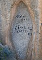 Engravings on the rocks

See also edit
References edit
- ^ "SAHRA - Home Page". Archived from the original on 31 December 2008. Retrieved 31 December 2008. South African Heritage Resource Agency database
This Northern Cape location article is a stub. You can help Wikipedia by expanding it. |