Horní Kozolupy is a municipality and village in Tachov District in the Plzeň Region of the Czech Republic. It has about 200 inhabitants.
Horní Kozolupy | |
|---|---|
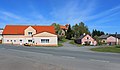
 Centre of Horní Kozolupy | |
 Flag  Coat of arms | |
 Horní Kozolupy Location in the Czech Republic | |
| Coordinates: 49°50′15″N 12°56′30″E / 49.83750°N 12.94167°E | |
| Country | |
| Region | Plzeň |
| District | Tachov |
| First mentioned | 1237 |
| Area | |
| • Total | 22.76 km2 (8.79 sq mi) |
| Elevation | 518 m (1,699 ft) |
| Population (2023-01-01)[1] | |
| • Total | 248 |
| • Density | 11/km2 (28/sq mi) |
| Time zone | UTC+1 (CET) |
| • Summer (DST) | UTC+2 (CEST) |
| Postal codes | 349 01, 349 52 |
| Website | www |
Horní Kozolupy lies approximately 24 kilometres (15 mi) east of Tachov, 33 km (21 mi) west of Plzeň, and 110 km (68 mi) west of Prague.
Administrative parts edit
The villages of Očín, Slavice and Strahov are administrative parts of Horní Kozolupy.
Demographics edit
| Year | Pop. | ±% |
|---|---|---|
| 1869 | 880 | — |
| 1880 | 889 | +1.0% |
| 1890 | 987 | +11.0% |
| 1900 | 992 | +0.5% |
| 1910 | 1,020 | +2.8% |
| 1921 | 930 | −8.8% |
| 1930 | 908 | −2.4% |
| 1950 | 498 | −45.2% |
| 1961 | 421 | −15.5% |
| 1970 | 392 | −6.9% |
| 1980 | 341 | −13.0% |
| 1991 | 291 | −14.7% |
| 2001 | 277 | −4.8% |
| 2011 | 231 | −16.6% |
| 2021 | 246 | +6.5% |
| Source: Censuses[2][3] | ||
Gallery edit
-
 Municipal office
 -
 Former primary school
 -
 The village of Slavice


References edit
- ^ "Population of Municipalities – 1 January 2023". Czech Statistical Office. 2023-05-23.
- ^ "Historický lexikon obcí České republiky 1869–2011 – Okres Tachov" (in Czech). Czech Statistical Office. 2015-12-21. pp. 5–6.
- ^ "Population Census 2021: Population by sex". Public Database. Czech Statistical Office. 2021-03-27.
External links edit
Wikimedia Commons has media related to Horní Kozolupy.
This Plzeň Region location article is a stub. You can help Wikipedia by expanding it. |