Guangfeng District (simplified Chinese: 广丰区; traditional Chinese: 廣豐區; pinyin: Guǎngfēng Qū; lit. 'Wide and luxuriant') is a district of the city of Shangrao, located in Northeastern Jiangxi Province, Eastern China.
Guangfeng
广丰区 Kwangfeng | |
|---|---|
 Juntan Reservoir | |
 Location in Jiangxi | |
| Coordinates: 28°26′18″N 118°10′46″E / 28.43833°N 118.17944°E | |
| Country | People's Republic of China |
| Province | Jiangxi |
| Prefecture-level city | Shangrao |
| Capital | Yongfeng |
| Area | |
| • Total | 1,377.79 km2 (531.97 sq mi) |
| Population (2017) | |
| • Total | 974,367 |
| • Density | 710/km2 (1,800/sq mi) |
| Time zone | UTC+8 (China Standard) |
| Postal code | 334600 |
| Area Code | 0793 |
| Vehicle registration | 赣E |
| Website | www |
The easternmost county-level division of Jiangxi, Guangfeng borders Zhejiang and Fujian provinces. It covers 1,377.79 km2 (531.97 sq mi).
The population is 760,000 people.
History edit
The district was first established during the Tang dynasty in 758 as a county, then repealed in 812. In 1074, during the Song dynasty, the district was reestablished as a county.
Administration edit
Guangfeng has been a county for over 1,300 years. Administratively, the district is part of the prefecture-level city of Shangrao. The county administers 23 townships.
At present, Guangfeng District has 3 subdistricts, 16 towns and 4 townships.[1]
- 3 subdistricts
- 16 towns
- 4 townships
Climate edit
The climate is temperate, with abundant rainfall during the monsoon season. It has clearly differentiated summers and winters.
| Climate data for Guangfeng (1991–2020 normals, extremes 1981–2010) | |||||||||||||
|---|---|---|---|---|---|---|---|---|---|---|---|---|---|
| Month | Jan | Feb | Mar | Apr | May | Jun | Jul | Aug | Sep | Oct | Nov | Dec | Year |
| Record high °C (°F) | 27.4 (81.3) |
29.6 (85.3) |
34.3 (93.7) |
35.4 (95.7) |
37.2 (99.0) |
38.0 (100.4) |
41.0 (105.8) |
41.4 (106.5) |
39.0 (102.2) |
37.2 (99.0) |
32.4 (90.3) |
25.9 (78.6) |
41.4 (106.5) |
| Mean daily maximum °C (°F) | 10.8 (51.4) |
13.5 (56.3) |
17.4 (63.3) |
23.6 (74.5) |
28.0 (82.4) |
30.1 (86.2) |
34.6 (94.3) |
34.2 (93.6) |
30.5 (86.9) |
25.5 (77.9) |
19.5 (67.1) |
13.4 (56.1) |
23.4 (74.2) |
| Daily mean °C (°F) | 6.4 (43.5) |
8.8 (47.8) |
12.5 (54.5) |
18.3 (64.9) |
23.0 (73.4) |
25.7 (78.3) |
29.4 (84.9) |
28.9 (84.0) |
25.3 (77.5) |
20.0 (68.0) |
14.2 (57.6) |
8.3 (46.9) |
18.4 (65.1) |
| Mean daily minimum °C (°F) | 3.4 (38.1) |
5.4 (41.7) |
8.9 (48.0) |
14.4 (57.9) |
19.2 (66.6) |
22.4 (72.3) |
25.3 (77.5) |
25.1 (77.2) |
21.5 (70.7) |
16.0 (60.8) |
10.3 (50.5) |
4.8 (40.6) |
14.7 (58.5) |
| Record low °C (°F) | −5.8 (21.6) |
−3.9 (25.0) |
−3.1 (26.4) |
1.9 (35.4) |
9.9 (49.8) |
13.3 (55.9) |
18.9 (66.0) |
19.0 (66.2) |
12.7 (54.9) |
4.0 (39.2) |
−1.8 (28.8) |
−9.6 (14.7) |
−9.6 (14.7) |
| Average precipitation mm (inches) | 87.5 (3.44) |
104.9 (4.13) |
207.4 (8.17) |
232.2 (9.14) |
219.5 (8.64) |
367.5 (14.47) |
149.8 (5.90) |
104.5 (4.11) |
73.0 (2.87) |
49.4 (1.94) |
92.8 (3.65) |
74.6 (2.94) |
1,763.1 (69.4) |
| Average precipitation days (≥ 0.1 mm) | 13.6 | 13.7 | 18.4 | 16.8 | 16.2 | 18.1 | 11.7 | 12.2 | 9.2 | 7.4 | 10.1 | 10.7 | 158.1 |
| Average snowy days | 2.8 | 1.8 | 0.2 | 0 | 0 | 0 | 0 | 0 | 0 | 0 | 0.1 | 0.9 | 5.8 |
| Average relative humidity (%) | 77 | 76 | 76 | 75 | 75 | 80 | 73 | 73 | 73 | 72 | 76 | 75 | 75 |
| Mean monthly sunshine hours | 89.8 | 90.9 | 100.7 | 126.6 | 148.1 | 133.9 | 230.8 | 220.1 | 182.5 | 169.2 | 131.5 | 120.1 | 1,744.2 |
| Percent possible sunshine | 27 | 29 | 27 | 33 | 35 | 32 | 54 | 55 | 50 | 48 | 41 | 38 | 39 |
| Source: China Meteorological Administration[2][3] | |||||||||||||
Economy edit
Guangfeng was once a poor district, but now it is one of the wealthiest counties of Jiangxi. The most famous industry of the district is the tobacco industry. The GDP of 2005 is 7.29 billion.
Features edit
Guangfeng's most famous feature is Boshan Temple, which lies in the west of the county. The Buddhist temple has a history over 1000 years. Xin Qiji, the famous poet of the South Song dynasty, visited it often.
Sheshantou Site, in Guangfeng District, is an important Neolithic archaeological site of Jiangxi Province.[4]
References edit
- ^ "常州市-行政区划网 www.xzqh.org" (in Chinese). XZQH. Retrieved 2012-05-24.
- ^ 中国气象数据网 – WeatherBk Data (in Simplified Chinese). China Meteorological Administration. Retrieved 28 June 2023.
- ^ 中国气象数据网 (in Simplified Chinese). China Meteorological Administration. Retrieved 28 June 2023.
- ^ Wan Z, Yang X, Quansheng G E, et al. Plant Resource Utilization at Sheshantou Site in Jiangxi Province Based on Starch Grain Analysis[J]. Progress in Geography, 2012.
Gallery edit
-

-
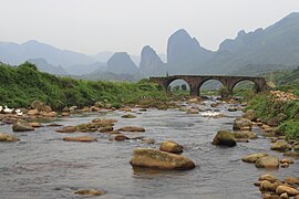 Liushiyan Hill
 -
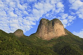
 Jiuxianshan Castle
 -
 Baihuayan Hill
 -
 Yushi Hill
 -
 Songfeng Temple
 -
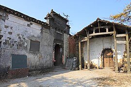
 Zhu's ancestral hall in Longxi


