Fockenstein is a 1,564-metre-high (5,131 ft) mountain in Bavaria, Germany. It is located in what is called the Bavarian Prealps, west of the lake Tegernsee.
| Fockenstein | |
|---|---|
 | |
| Highest point | |
| Elevation | 1,564 m (5,131 ft)[1] |
| Prominence | 308 m (1,010 ft)[2] |
| Coordinates | ♁47° 41′ 5″ N, 11° 39′ 9″ O |
| Geography | |
| Location | Bavaria, Germany |
| Climbing | |
| Easiest route | Hike |
Geography and Climbing edit
The summit is on the border between the municipalities of Gaißach and Bad Wiessee. It is usually climbed from Bad Wiessee but can also be climbed from Lenggries via Geierstein.[1] Fockenstein is also often climbed in winter, especially as part of a rather easy ski tour. While the path to the Aueralm can usually be mastered without any problems, the steep summit slopes must be assessed for avalanche danger.[3] The Maximiliansweg from Füssen to Königssee also leads over the Fockenstein. In summer, two hours are required for the ascent from Bad Wiessee and 1.5 hours for the descent.[4] From Lenggries (from Hohenburg Castle) over the Hirschtalsattel the ascent takes about 2.5 hours and the descent about two hours.
Photos edit

-
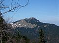 Fockenstein and Neuhüttenalm, as seen from Hirschberg
 -
 Summit cross with Tegernsee in the background
 -
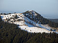 South slope


References edit
- ^ a b Zebhauser, Marianne; Zebhauser, Emmeram. Bayerische Voralpen Ost (PDF) (1992 ed.). München: Bergverlag Rudolf Rother. pp. 241–242.
- ^ "Fockenstein - Peakbagger.com". peakbagger.com. Retrieved 25 May 2022.
- ^ Riffler, Bernd; Steiger, Rudolf (1987). Winterbergtouren ohne Ski zwischen Berchtesgaden und Allgäu. München: Bruckmann. p. 83. ISBN 3-7654-2139-1.
- ^ Hackl, Didi. "Fockenstein (1564 m), Mangfallgebirge, Tegernsee, Deutschland". www.hoehenrausch.de. Retrieved 25 May 2022.
47°41′N 11°39′E / 47.683°N 11.650°E
This Bavaria location article is a stub. You can help Wikipedia by expanding it. |