File:VIEW OF WEST SIDE OF BRIDGE, LOOKING EAST - Palm Tree Road Bridge, Spanning Sheboygan River on Palm Tree Road, Saint Cloud, Fond du Lac County, WI HAER WIS,20-SACLO,1-1.tif

Size of this JPG preview of this TIF file: 724 × 600 pixels. Other resolutions: 290 × 240 pixels | 579 × 480 pixels | 927 × 768 pixels | 1,236 × 1,024 pixels | 2,471 × 2,048 pixels | 4,740 × 3,928 pixels.
Original file (4,740 × 3,928 pixels, file size: 17.76 MB, MIME type: image/tiff)
| This is a file from the Wikimedia Commons. Information from its description page there is shown below. Commons is a freely licensed media file repository. You can help. |
Summary
| VIEW OF WEST SIDE OF BRIDGE, LOOKING EAST - Palm Tree Road Bridge, Spanning Sheboygan River on Palm Tree Road, Saint Cloud, Fond du Lac County, WI | ||||
|---|---|---|---|---|
| Title |
VIEW OF WEST SIDE OF BRIDGE, LOOKING EAST - Palm Tree Road Bridge, Spanning Sheboygan River on Palm Tree Road, Saint Cloud, Fond du Lac County, WI |
|||
| Description |
Halter, Alphonse |
|||
| Depicted place | Wisconsin; Fond du Lac County; Saint Cloud | |||
| Date | Documentation compiled after 1968 | |||
| Dimensions | 4 x 5 in. | |||
| Current location |
Library of Congress Prints and Photographs Division Washington, D.C. 20540 USA http://hdl.loc.gov/loc.pnp/pp.print |
|||
| Accession number |
HAER WIS,20-SACLO,1-1 |
|||
| Credit line |
|
|||
| Notes |
|
|||
| Source | https://www.loc.gov/pictures/item/wi0200.photos.170188p | |||
| Permission (Reusing this file) |
|
|||

| Camera location | | View this and other nearby images on: OpenStreetMap |
|---|
File history
Click on a date/time to view the file as it appeared at that time.
| Date/Time | Thumbnail | Dimensions | User | Comment | |
|---|---|---|---|---|---|
| current | 02:26, 5 August 2014 | 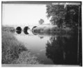 | 4,740 × 3,928 (17.76 MB) | Fæ | GWToolset: Creating mediafile for Fæ. HABS 2014-08-04 (3601:3800) Penultimate Tranche! |
File usage
The following pages on the English Wikipedia use this file (pages on other projects are not listed):
Global file usage
The following other wikis use this file:
- Usage on fr.wikipedia.org
- Usage on www.wikidata.org