
Size of this JPG preview of this PDF file: 503 × 599 pixels. Other resolutions: 201 × 240 pixels | 403 × 480 pixels | 645 × 768 pixels | 1,093 × 1,302 pixels.
Original file (1,093 × 1,302 pixels, file size: 42 KB, MIME type: application/pdf)
| This is a file from the Wikimedia Commons. Information from its description page there is shown below. Commons is a freely licensed media file repository. You can help. |
Summary
| Description |
English: The triangulation of the U. S. Geological Survey is executed solely
for the primary control of topographic work upon scales not exceeding 1:62500. The extreme of accuracy has therefore not been sought, but only such a degree of accuracy as to ensure that the maximum accumulated error be imperceptible upon the maps. John Lounsbury Fish worked on this USGS project in the 1891 timeframe and on the highlighted points. |
| Date | |
| Source | https://pubs.usgs.gov/bul/0122/report.pdf |
| Author | United States Geologic Survey |
Licensing
This work is in the public domain in the United States because it is a work prepared by an officer or employee of the United States Government as part of that person’s official duties under the terms of Title 17, Chapter 1, Section 105 of the US Code.
Note: This only applies to original works of the Federal Government and not to the work of any individual U.S. state, territory, commonwealth, county, municipality, or any other subdivision. This template also does not apply to postage stamp designs published by the United States Postal Service since 1978. (See § 313.6(C)(1) of Compendium of U.S. Copyright Office Practices). It also does not apply to certain US coins; see The US Mint Terms of Use.
|
 | |
| This file has been identified as being free of known restrictions under copyright law, including all related and neighboring rights. | ||
File history
Click on a date/time to view the file as it appeared at that time.
| Date/Time | Thumbnail | Dimensions | User | Comment | |
|---|---|---|---|---|---|
| current | 19:07, 24 October 2018 | 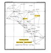 | 1,093 × 1,302 (42 KB) | Risk Engineer | User created page with UploadWizard |
File usage
The following pages on the English Wikipedia use this file (pages on other projects are not listed):