File:Historic American Buildings Survey Marc Blair Photographer, summer 1966 Detail of South Side of Southwest Corner - Capital Traction Company Union Station, 3600 M Street Northwest, HABS DC,GEO,84-6.tif

Size of this JPG preview of this TIF file: 477 × 599 pixels. Other resolutions: 191 × 240 pixels | 382 × 480 pixels | 612 × 768 pixels | 815 × 1,024 pixels | 1,631 × 2,048 pixels | 3,975 × 4,991 pixels.
Original file (3,975 × 4,991 pixels, file size: 18.92 MB, MIME type: image/tiff)
| This is a file from the Wikimedia Commons. Information from its description page there is shown below. Commons is a freely licensed media file repository. You can help. |
Summary
| Historic American Buildings Survey Marc Blair Photographer, summer 1966 Detail of South Side of Southwest Corner - Capital Traction Company Union Station, 3600 M Street Northwest, Washington, District of Columbia, DC | ||||
|---|---|---|---|---|
| Title |
Historic American Buildings Survey Marc Blair Photographer, summer 1966 Detail of South Side of Southwest Corner - Capital Traction Company Union Station, 3600 M Street Northwest, Washington, District of Columbia, DC |
|||
| Depicted place | District of Columbia; District of Columbia; Washington | |||
| Dimensions | 4 x 5 in. | |||
| Current location |
Library of Congress Prints and Photographs Division Washington, D.C. 20540 USA http://hdl.loc.gov/loc.pnp/pp.print |
|||
| Accession number |
HABS DC,GEO,84-6 |
|||
| Credit line |
|
|||
| Source | https://www.loc.gov/pictures/item/dc0048.photos.025813p | |||
| Permission (Reusing this file) |
|
|||

| Camera location | | View this and other nearby images on: OpenStreetMap |
|---|
File history
Click on a date/time to view the file as it appeared at that time.
| Date/Time | Thumbnail | Dimensions | User | Comment | |
|---|---|---|---|---|---|
| current | 10:43, 8 July 2014 | 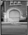 | 3,975 × 4,991 (18.92 MB) | Fæ | GWToolset: Creating mediafile for Fæ. HABS 08 July 2014 (701:800) |
File usage
The following pages on the English Wikipedia use this file (pages on other projects are not listed):