
Size of this PNG preview of this SVG file: 387 × 600 pixels. Other resolutions: 155 × 240 pixels | 310 × 480 pixels | 495 × 768 pixels | 660 × 1,024 pixels | 1,321 × 2,048 pixels | 771 × 1,195 pixels.
Original file (SVG file, nominally 771 × 1,195 pixels, file size: 2.03 MB)
| This is a file from the Wikimedia Commons. Information from its description page there is shown below. Commons is a freely licensed media file repository. You can help. |
Summary
| Description |
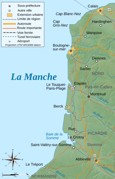
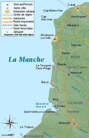
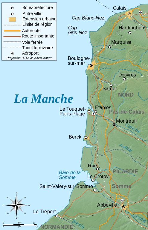
Deutsch: Topographische Karte von Côte d'Opale, französische Version English: Topographic map in French of Côte d'Opale Français : Carte topographique en français de la Côte d'Opale |
| Date | |
| Source |
English: Own work ; Topographic data from the NASA Shuttle Radar Topography Mission (SRTM3 v.2) (public domain) edited with 3DEM, and vectorized with Inkscape ; UTM projection ; WGS84 datum ; shaded relief (composite image of N-W lightning position) ; Reference used for the additional data : * Rivers, cities, railroads, routes: Demis add-on for World Wind (see the approval e-mail and the Demis forum) + viamichelin for highways ; * Borders and coast : World data bank II ; Note : The relief is a raster image embedded in the SVG file. Français : Création personnelle ; Données topographiques de la NASA Shuttle Radar Topography Mission (SRTM3 v.2) (domaine public) éditées avec 3DEM et vectorisées avec Inkscape ; projection UTM ; WGS84 datum ; relief ombré (éclairage du N-O) ; Références utilisées pour les données complémentaires : * Rivières, villes, chemins de fers, routes : Demis add-on for World Wind (see the approval e-mail and the Demis forum) + viamichelin pour les autoroutes ; * Frontières et côtes : World data bank II ; Note : Le relief est une image bitmap embarquée dans le fichier SVG. Approximate geographic limits of the map (30" close) : * SW corner : 49°99'00"N – 01°00'00"E * SE corner : 59°99'00"N – 01°99'00"E * NE corner : 51°00'00"N – 1°99'00"E * NW corner : 51°00'00"N – 1°00'00"E |
| Author | Bourrichon - fr:Bourrichon) |
| Permission (Reusing this file) |
GFDL / Attribution and Share-Alike required |

|
This SVG file contains embedded text that can be translated into your language, using any capable SVG editor, text editor or the SVG Translate tool. For more information see: About translating SVG files. |
Licensing
I, the copyright holder of this work, hereby publish it under the following licenses:

|
Permission is granted to copy, distribute and/or modify this document under the terms of the GNU Free Documentation License, Version 1.2 or any later version published by the Free Software Foundation; with no Invariant Sections, no Front-Cover Texts, and no Back-Cover Texts. A copy of the license is included in the section entitled GNU Free Documentation License. |
This file is licensed under the Creative Commons Attribution-Share Alike 4.0 International, 3.0 Unported, 2.5 Generic, 2.0 Generic and 1.0 Generic license.
- You are free:
- to share – to copy, distribute and transmit the work
- to remix – to adapt the work
- Under the following conditions:
- attribution – You must give appropriate credit, provide a link to the license, and indicate if changes were made. You may do so in any reasonable manner, but not in any way that suggests the licensor endorses you or your use.
- share alike – If you remix, transform, or build upon the material, you must distribute your contributions under the same or compatible license as the original.
You may select the license of your choice.
File history
Click on a date/time to view the file as it appeared at that time.
| Date/Time | Thumbnail | Dimensions | User | Comment | |
|---|---|---|---|---|---|
| current | 12:57, 7 March 2009 | | 771 × 1,195 (2.03 MB) | Bourrichon | + corr erreur |
| 12:50, 7 March 2009 |  | 771 × 1,195 (159 KB) | Bourrichon | == Summary == {{Information |Description={{de|Topographische Karte von Côte d'Opale, französische Version}}{{en|Topographic map in French of Côte d'Opale}}{{fr|Carte topographique en français de la [[:fr:Cô |
File usage
The following pages on the English Wikipedia use this file (pages on other projects are not listed):
Global file usage
The following other wikis use this file:
- Usage on bg.wikipedia.org
- Usage on de.wikipedia.org
- Usage on eo.wikipedia.org
- Usage on es.wikipedia.org
- Usage on fr.wikipedia.org
- Étaples
- Le Touquet-Paris-Plage
- Baie de Somme
- Côte d'Opale
- Poulier
- Parc naturel marin des estuaires picards et de la mer d'Opale
- Dunes d'Écault
- Berck (Pas-de-Calais)
- Portail:Boulogne-sur-Mer
- Plage du Touquet-Paris-Plage
- Portail:Côte d'Opale
- Unité urbaine de Berck
- Portail:Côte d'Opale/Introduction
- Portail:Le Touquet-Paris-Plage
- Portail:Le Touquet-Paris-Plage/Index thématique
- Portail:Boulogne-sur-Mer/Index thématique
- Wikipédia:Atelier graphique/Cartes/Archives/mai 2017
- Opération Undergo
- Modèle:Géolocalisation/Côte d'Opale
- Usage on hu.wikipedia.org
- Usage on it.wikipedia.org
- Usage on nl.wikipedia.org
- Usage on pcd.wikipedia.org
- Usage on pl.wikipedia.org
- Usage on ro.wikipedia.org
- Usage on vls.wikipedia.org
- Usage on www.wikidata.org