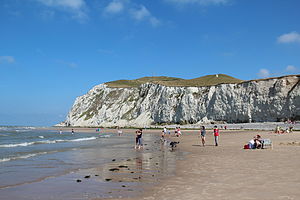
The Opal Coast (Côte d'Opale (French) French pronunciation: [kot dɔpal]; Opoalkust (West Flemish)) is a coastal region in northern France on the English Channel, popular with tourists.


Geography edit
The Côte d'Opale is a coastal region in northeastern France, in the departments of Nord and Pas-de-Calais. It extends over 120 kilometres (75 mi) of French coast between the Belgian border and the border with Picardy. This coastline faces the English Channel and the North Sea, and is situated directly opposite the chalk cliffs of southeast England, which at the closest point are only 34 kilometres (21 mi) away.
The Côte d'Opale is composed of many varied landscapes including beaches, dunes, swamps, estuaries and cliffs. The coast is marked by the presence of two large promontories situated between Calais and Boulogne: the Cap Gris Nez (literally "grey nose cape" in English), reaching an elevation of 50 metres (160 ft) above sea level, and the Cap Blanc Nez (literally "white nose cape" in English), which reaches 132 metres (433 ft). These capes are the closest points to England on the entire French coast.
Cities edit
Famous seaside resorts edit
From south to north:
- Berck
- Le Touquet-Paris-Plage
- Sainte-Cécile-Plage
- Hardelot-Plage
- Équihen-Plage
- Wimereux
- Audresselles
- Ambleteuse
- Wissant
- Blériot-Plage
- Bray-Dunes
Other communes of the coast edit
From south to north:
Arts edit
Many artists have been inspired by the coast's landscapes, among them the composer Henri Dutilleux, the writers Victor Hugo and Charles Dickens, and the painters J. M. W. Turner, Carolus-Duran, Maurice Boitel and Eugène Boudin. It was the painter Édouard Lévêque who coined the name for this area in 1911 to describe the distinctive quality of its light.[1]
See also edit
References edit
- ^ Le Touquet-Paris-Plage à l’aube de son nouveau siècle, éditions Flandres-Artois-Côte d’Opale, 1982, p.22
External links edit
- Travel Guide of the Opal Coast / Côte d'Opale
- Accommodation on the Opal Coast / Côte d'Opale
- Côte d'Opale through photos : You will love it !
- Côte d'Opale : Tourism, shopping, B&B
- Le Cap Blanc Nez
- Le Cap Gris Nez
- Le Grand Site des 2 Caps
- Slipping on Côte d'Opale : B&b, Gîtes, Hôtels ...
- Tourism in Boulogne sur Mer and the Boulonnais area (in English)
- Cape Blanc Nez Archived 2017-02-08 at the Wayback Machine
- Cape Gris Nez Archived 2016-10-24 at the Wayback Machine
50°30′N 1°35′E / 50.500°N 1.583°E