
Size of this PNG preview of this TIF file: 600 × 600 pixels. Other resolutions: 240 × 240 pixels | 480 × 480 pixels | 768 × 768 pixels | 1,025 × 1,024 pixels | 1,801 × 1,800 pixels.
Original file (1,801 × 1,800 pixels, file size: 12.38 MB, MIME type: image/tiff)
| This is a file from the Wikimedia Commons. Information from its description page there is shown below. Commons is a freely licensed media file repository. You can help. |
Summary
| Description |
English: Visible satellite image of system 10E on 18Z August 2, 2018. |
| Date | |
| Source | NOAA Big Data |
| Author | NOAA |
Licensing
This image is in the public domain because it contains materials that originally came from the U.S. National Oceanic and Atmospheric Administration, taken or made as part of an employee's official duties.
|
File history
Click on a date/time to view the file as it appeared at that time.
| Date/Time | Thumbnail | Dimensions | User | Comment | |
|---|---|---|---|---|---|
| current | 21:33, 3 August 2018 |  | 1,801 × 1,800 (12.38 MB) | Supportstorm | Brighten |
| 21:06, 3 August 2018 | 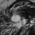 | 1,801 × 1,800 (12.38 MB) | Supportstorm | == {{int:filedesc}} == {{Information |description ={{en|1=Visible satellite image of system 10E on 18Z August 2, 2018.}} |date =2018-08-02 |source =NOAA Big Data |author =NOAA }} == {{int:license-header}} == {{PD-USGov-NOAA}} Category:Satellite pictures of Hurricane Hector (2018) |
File usage
The following pages on the English Wikipedia use this file (pages on other projects are not listed):
Global file usage
The following other wikis use this file:
- Usage on pt.wikipedia.org
- Usage on zh.wikipedia.org