Een [eːn] is a village in the Netherlands. It is part of the Noordenveld municipality in Drenthe.
Een | |
|---|---|
 Main street Een | |
 Flag | |
 Een Location in province of Drenthe in the Netherlands  Een Een (Netherlands) | |
| Coordinates: 53°4′32″N 6°23′38″E / 53.07556°N 6.39389°E | |
| Country | Netherlands |
| Province | Drenthe |
| Municipality | Noordenveld |
| Area | |
| • Total | 0.81 km2 (0.31 sq mi) |
| Elevation | 7 m (23 ft) |
| Population (2021)[1] | |
| • Total | 540 |
| • Density | 670/km2 (1,700/sq mi) |
| Time zone | UTC+1 (CET) |
| • Summer (DST) | UTC+2 (CEST) |
| Postal code | 9342 |
| Dialing code | 0592 |
History edit
Een is an esdorp which developed in the middle ages on the higher grounds. The communal pasture is triangular. The village developed during the 19th and early 20th century during the exploration of the peat in the area.[3] In 1840, it was home to 134 people.[4] The earliest church was from 1858, but no longer exists.[4] The Dutch Reformed Church dates from 1913.[3] It used to be a linear settlement, but has developed into a cluster.[4]
Een has become a recreational area with forests and heaths.[4]
Gallery edit
-
 Houses in Een
 -
 Heath near Een
 -
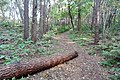 Forest near Een


References edit
- ^ a b "Kerncijfers wijken en buurten 2021". Central Bureau of Statistics. Retrieved 9 March 2022.
- ^ "Postcodetool for 9342PA". Actueel Hoogtebestand Nederland (in Dutch). Het Waterschapshuis. Retrieved 9 March 2022.
- ^ a b Ronald Stenvert (2001). Een (in Dutch). Zwolle: Waanders. ISBN 90 400 9454 3. Retrieved 9 March 2022.
- ^ a b c d "Een". Plaatsengids (in Dutch). Retrieved 9 March 2022.
External links edit
Look up een in Wiktionary, the free dictionary.
 Media related to Een (Noordenveld) at Wikimedia Commons
This Drenthe location article is a stub. You can help Wikipedia by expanding it. |