Dunlop Parish is a civil parish,[1] of Yanda County, a cadasteral division of New South Wales;[2] a Cadastral division of New South Wales.[3][4][5][6]
| Dunlop Parish New South Wales | |
|---|---|
 | |
 Dunlop Parish | |
| Coordinates | 30°32′0″S 145°07′0″E / 30.53333°S 145.11667°E |
| Postcode(s) | 2840 |
| Elevation | 100 m (328 ft) |
| LGA(s) | Bourke Shire |
| State electorate(s) | Barwon |
| Federal division(s) | Parkes |
Location edit
The Parish is on the Darling River upstream of Wilcannia, New South Wales[7][8] and down stream of Bourke, New South Wales.
The only town of the parish is Louth, New South Wales.
Geography edit
The topography is flat with a Köppen climate classification of BsK (Hot semi arid).[9]
The economy in the parish is based on broad acre agriculture, mainly Wheat, and sheep.
-
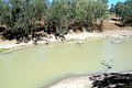 Darling River Dunlop Parish
 -
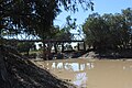 Louth bridge 1.JPG Dunlop Parish
 -
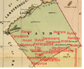


_Australia.png)
The Dunlop Ranges are in the parish.
History edit
The traditional owners of the area are the Barkindji people,[10][11] The first European to the area was Thomas Mitchell (explorer).
In 1859 when Thomas Andrew Mathews, an Irish immigrant from County Louth, built a pub to serve the passing trade along the Darling River.
In 1888 the first mechanised shearing of sheep, in the world, took place at Sir Samuel McCaughey's Dunlop Station.[12]
External links edit
- Charles Bayliss, View from Dunlop Range, near Louth, Darling River looking south (1886).
- Charles. Bayliss, Homestead, Dunlop Station, Darling River (1886) , National Gallery of Victoria, Melbourne.
References edit
- ^ Map of the County of Yanda, Western Division, NSW 1918.
- ^ [cartographer] C.A. Orwin, [https://nla.gov.au/nla.obj-233873384/view Map of the County of Rankin : Western Division, Land Districts of Bourke, Cobar and Wilcannia, N.S.W. 1912 (New South Wales. Department of Lands Title, Sydney N.S.W. 1914).
- ^ "Rankin". Geographical Names Register (GNR) of NSW. Geographical Names Board of New South Wales. Retrieved 4 August 2013.
- ^ The New atlas of Australia (John Sands, 1886) map 24.
- ^ Yanda County Archived 6 May 2018 at the Wayback Machine, GEOGRAPHICAL NAMES REGISTER EXTRACT.
- ^ / The New atlas of Australia, (John Sands, 1886), map 24.
- ^ [cartographer] C.A. Orwin, [https://nla.gov.au/nla.obj-233873384/view Map of the County of Rankin : Western Division, Land Districts of Bourke, Cobar and Wilcannia, N.S.W. 1912 (New South Wales. Department of Lands Title, Sydney N.S.W. 1914).
- ^ The New atlas of Australia (John Sands, 1886) map 24.
- ^ Peel, M. C.; Finlayson, B. L.; McMahon, T. A. (2007). "Updated world map of the Köppen–Geiger climate classification". Hydrol. Earth Syst. Sci. 11: 1633–1644. doi:10.5194/hess-11-1633-2007. ISSN 1027-5606. (direct: Final Revised Paper)
- ^ Norman Tindale's Catalogue of Australian Aboriginal Tribes
- ^ Aboriginal Australia Map, David Horton (ed.), 1994 published in The Encyclopedia of Aboriginal Australia by AIATSIS.
- ^ Trilby Station Archived 2 April 2012 at the Wayback Machine Retrieved 26 September 2011