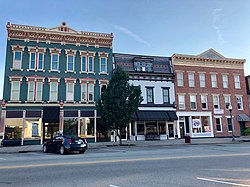
Downtown Lawrenceburg Historic District is a national historic district located at Lawrenceburg, Dearborn County, Indiana. The district encompasses 257 contributing buildings and 2 contributing objects in the central business district and surrounding residential sections of Lawrenceburg. The district developed between about 1815 and 1900, and includes notable examples of Late Victorian, Federal, and Greek Revival style architecture. Located in the district are the separately listed Dearborn County Courthouse and Hamline Chapel United Methodist Church. Other notable buildings include the Trade and Industrial Building (1881), Lawrenceburg Theater (1875), Jesse Hunt Hotel (1818), the birthplaces of James B. Eads and Louis Skidmore.[2]
Downtown Lawrenceburg Historic District | |
 Contributing Structures on Walnut Street in the Historic District | |
| Location | Roughly bounded by ConRail Tracks, Charlotte, Tate, Williams, and Elm Sts., Lawrenceburg, Indiana |
|---|---|
| Coordinates | 39°05′37″N 84°50′54″W / 39.09361°N 84.84833°W |
| Area | 65 acres (26 ha) |
| Built | 1802 |
| Architectural style | Late Victorian, Federal, Greek Revival |
| NRHP reference No. | 84001009[1] |
| Added to NRHP | March 1, 1984 |
It was added to the National Register of Historic Places in 1984.[1]
References edit
- ^ a b "National Register Information System". National Register of Historic Places. National Park Service. July 9, 2010.
- ^ "Indiana State Historic Architectural and Archaeological Research Database (SHAARD)" (Searchable database). Department of Natural Resources, Division of Historic Preservation and Archaeology. Retrieved August 1, 2015. Note: This includes David W. Shaw (June 1983). "National Register of Historic Places Inventory Nomination Form: Downtown Lawrenceburg Historic District" (PDF). Retrieved September 1, 2015. and Accompanying photographs and map.
External links edit
- Media related to Downtown Lawrenceburg Historic District at Wikimedia Commons

