Devils Prongs is a 2,175-foot-elevation (663-meter) mountain in Alaska.
| Devils Prongs | |
|---|---|
 Northeast aspect | |
| Highest point | |
| Elevation | 2,175 ft (663 m)[1] |
| Prominence | 561 ft (171 m)[2] |
| Parent peak | Peak 2329[2] |
| Isolation | 1.28 mi (2.06 km)[2] |
| Coordinates | 57°48′45″N 152°28′00″W / 57.8125000°N 152.4666667°W[3] |
| Geography | |
 Devils Prongs Location in Alaska | |
| Country | United States |
| State | Alaska |
| Borough | Kodiak Island Borough[3] |
| Parent range | Kodiak Archipelago[1] |
| Topo map | USGS Kodiak D-2 |
Description edit
Devils Prongs is located two miles (3.2 km) northwest of Kodiak at the head of Monaska Bay on the northeast coast of Kodiak Island.[3] Precipitation runoff from the three peaks of the mountain drains north into Virginia Creek and south into Pillar Creek before each empty into Monaska Bay. Topographic relief is significant as the mountain rises over 2,000 feet (610 meters) above tidewater of Monaska Bay in approximately zero point seven five miles (1.21 km). The mountain's name was applied in 1869 by the United States Coast and Geodetic Survey and the toponym was officially adopted in 1966 by the United States Board on Geographic Names.[3] Russian naval officers in 1808 gave this landform the descriptive name Gory Chyernysheva, meaning "Black Mountains."[4]
Climate edit
According to the Köppen climate classification system, Devils Prongs is located in a subpolar oceanic climate zone with cold, snowy winters, and cool summers.[5] Weather systems coming off the North Pacific are forced upwards by the mountains (orographic lift), causing heavy precipitation in the form of rainfall and snowfall. Winter temperatures can drop to 0 °F with wind chill factors below −10 °F.
See also edit
Gallery edit
-
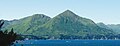 East aspect
 -
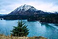 Northernmost of three peaks of Devils Prongs viewed across Monashka Bay

References edit
- ^ a b "Devils Prongs West, Alaska". Peakbagger.com. Retrieved 2023-12-16.
- ^ a b c "Devils Prongs, South - 2,168' AK". listsofjohn.com. Retrieved 2023-12-16.
- ^ a b c d "Devils Prongs". Geographic Names Information System. United States Geological Survey, United States Department of the Interior. Retrieved 2023-12-16.
- ^ Donald J. Orth, Dictionary of Alaska Place Names, U.S. Government Printing Office, 1967, page 269.
- ^ Peel, M. C.; Finlayson, B. L.; McMahon, T. A. (2007). "Updated world map of the Köppen−Geiger climate classification". Hydrol. Earth Syst. Sci. 11. ISSN 1027-5606.