Darling is a census-designated place in Quitman County, Mississippi. Darling is located on Mississippi Highway 3, north of Marks. Per the 2020 Census, the population was 154.[3]
Darling, Mississippi | |
|---|---|
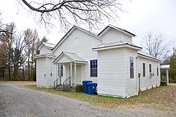
 Darling, Ms Greater Zion MB Baptist Church Historical African-American church | |
| Coordinates: 34°21′32″N 90°16′27″W / 34.35889°N 90.27417°W | |
| Country | United States |
| State | Mississippi |
| County | Quitman |
| Area | |
| • Total | 2.71 sq mi (7.01 km2) |
| • Land | 2.71 sq mi (7.01 km2) |
| • Water | 0.00 sq mi (0.00 km2) |
| Elevation | 164 ft (50 m) |
| Population (2020) | |
| • Total | 154 |
| • Density | 56.87/sq mi (21.96/km2) |
| Time zone | UTC-6 (Central (CST)) |
| • Summer (DST) | UTC-5 (CDT) |
| Area code | 662 |
| GNIS feature ID | 669113[2] |
The settlement was named after Mr. Darling, a railroad official.[4]
Education edit
It is in the Quitman County School District.
Demographics edit
| Census | Pop. | Note | %± |
|---|---|---|---|
| 2010 | 226 | — | |
| 2020 | 154 | −31.9% | |
| U.S. Decennial Census[5] 2010[6] 2020[7] | |||
2020 census edit
| Race / Ethnicity | Pop 2010[6] | Pop 2020[7] | % 2010 | % 2020 |
|---|---|---|---|---|
| White alone (NH) | 32 | 19 | 14.16% | 12.34% |
| Black or African American alone (NH) | 189 | 130 | 83.63% | 84.42% |
| Native American or Alaska Native alone (NH) | 0 | 0 | 0.00% | 0.00% |
| Asian alone (NH) | 0 | 1 | 0.00% | 0.65% |
| Pacific Islander alone (NH) | 0 | 0 | 0.00% | 0.00% |
| Some Other Race alone (NH) | 0 | 0 | 0.00% | 0.00% |
| Mixed Race/Multi-Racial (NH) | 0 | 4 | 0.00% | 2.60% |
| Hispanic or Latino (any race) | 5 | 0 | 2.21% | 0.00% |
| Total | 226 | 154 | 100.00% | 100.00% |
Note: the US Census treats Hispanic/Latino as an ethnic category. This table excludes Latinos from the racial categories and assigns them to a separate category. Hispanics/Latinos can be of any race.
Transportation edit
Amtrak’s City of New Orleans, which operates between New Orleans and Chicago, passes through the town on CN tracks, but makes no stop. The nearest station is located in Marks, 7 miles (11 km) to the south.
References edit
- ^ "2020 U.S. Gazetteer Files". United States Census Bureau. Retrieved July 24, 2022.
- ^ "US Board on Geographic Names". United States Geological Survey. October 25, 2007. Retrieved January 31, 2008.
- ^ "Darling CDP, Mississippi". United States Census Bureau. Retrieved March 13, 2022.
- ^ Moyer, Armond; Moyer, Winifred (1958). The origins of unusual place-names. Keystone Pub. Associates. p. 31.
- ^ "Decennial Census of Population and Housing by Decades". US Census Bureau.
- ^ a b "P2 HISPANIC OR LATINO, AND NOT HISPANIC OR LATINO BY RACE – 2010: DEC Redistricting Data (PL 94-171) – Darling CDP, Mississippi". United States Census Bureau.
- ^ a b "P2 HISPANIC OR LATINO, AND NOT HISPANIC OR LATINO BY RACE – 2020: DEC Redistricting Data (PL 94-171) – Darling CDP, Mississippi". United States Census Bureau.
