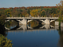
The Cummings Bridge in Ottawa, Ontario, Canada, crosses the Rideau River, connecting Rideau Street to Montreal Road in Vanier. It is a multi-span open spandrel arch bridge, constructed in 1921 and renovated in 1996.[1]
Cummings Bridge | |
|---|---|
 | |
| Coordinates | 45°26′00″N 75°40′16″W / 45.433199°N 75.6712°W |
| Carries | 4-lane road, sidewalks, bicycle lane |
| Crosses | Rideau River |
| Locale | Ottawa, Ontario, Canada |
| Named for | Charles Cummings |
| Characteristics | |
| Material | Reinforced concrete |
| Total length | 213 m (699 ft)[1] |
| Width | 18.21 m (59.7 ft)[1] |
| History | |
| Construction start | 1921 |
| Rebuilt | 1996 |
| Location | |
 | |
History edit
The area east of the Cummings Bridge, later named Vanier was first linked to the Sandy Hill area of Ottawa with a wooden bridge erected in 1835, which went over Cummings Island in the Rideau River. The Cummings family settled the island, had a store there, and the island and bridge there became associated with the Cummings name.[2] In 1891, the old wooden bridge was replaced by a steel bridge, which the city wanted to name Bingham's Bridge, after Ottawa mayor Samuel Bingham, but this name never caught on.[3]
The current bridge was constructed in 1921, some 12 metres (39 ft) downstream from the steel bridge, bypassing Cummings Island.[3]
Charles Cummings had a son, Robert Cummings who became Reeve of Gloucester Township and Warden of Carleton County, Ontario. [4]
References edit
- ^ a b c "Restoring the Cummings Bridge". www.canadianconsultingengineer.com. Canadian Consulting Engineer. January 1, 2001. Retrieved 18 January 2018.
- ^ Haig 1975, pp. 160.
- ^ a b Deachman, Bruce (September 20, 2015). "Cummings Island: A former commercial hub now sits empty". Ottawa Citizen. Retrieved January 17, 2018.
- ^ Haig 1975, pp. 77.
- Bibliography
- Haig, Robert (1975), Ottawa: City of the Big Ears, Ottawa: Haig and Haig Publishing Co.