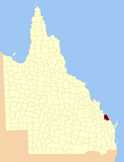
County of Flinders, Queensland

The County of Flinders is a county (a cadastral division) in Queensland, Australia, located in the Central Queensland region between Gladstone and Bundaberg.[1][2][3] The county is divided into civil parishes. It was named for Matthew Flinders who explored the Australian coastline.

Flinders
Queensland
Location within Queensland
Lands administrative divisions around Flinders:
Clinton Coral Sea Coral Sea
Clinton Flinders Coral Sea
Yarrol Bowen Cook

The county was created on 1 September 1855 by royal proclamation under the Waste Lands Australia Act 1846.[4] On 7 March 1901, the Governor issued a proclamation legally dividing Queensland into counties under the Land Act 1897.[5] Its schedule described Flinders thus:

Bounded on the south by the counties of Cook and Bowen; on the west by the county of Yarrol, the eastern watershed of the Boyne River, and the western boundary of the parist of Rodds Bay; and on the north and east by the Pacific Ocean.

Parishes edit

Flinders is divided into parishes, as listed below:

Parish LGA Coordinates Towns
Arthurs Seat Gladstone 24°17′S 151°42′E / 24.283°S 151.700°E / -24.283; 151.700 (Arthurs Seat Parish)
Baffle Gladstone 24°28′S 151°57′E / 24.467°S 151.950°E / -24.467; 151.950 (Baffle Parish)
Bulburin Gladstone 24°32′S 151°34′E / 24.533°S 151.567°E / -24.533; 151.567 (Bulburin Parish)
Bunker Gladstone 23°46′S 152°22′E / 23.767°S 152.367°E / -23.767; 152.367 (Bunker Parish)
Euleilah Gladstone 24°31′S 151°50′E / 24.517°S 151.833°E / -24.517; 151.833 (Euleilah Parish)
Eurimbula Gladstone 24°07′S 151°43′E / 24.117°S 151.717°E / -24.117; 151.717 (Eurimbula Parish) Town of 1770
Littabella Bundaberg 24°40′S 152°05′E / 24.667°S 152.083°E / -24.667; 152.083 (Littabella Parish) Watalgan
Miriam Vale Gladstone 24°22′S 151°35′E / 24.367°S 151.583°E / -24.367; 151.583 (Miriam Vale Parish) Miriam Vale
Polmaily Gladstone 24°20′S 151°29′E / 24.333°S 151.483°E / -24.333; 151.483 (Polmaily Parish) Bororen
Rodds Bay Gladstone 24°06′S 151°32′E / 24.100°S 151.533°E / -24.100; 151.533 (Rodds Bay Parish)
Rosedale Gladstone 24°41′S 151°51′E / 24.683°S 151.850°E / -24.683; 151.850 (Rosedale Parish) Rosedale (S)
Taunton Gladstone 24°24′S 151°44′E / 24.400°S 151.733°E / -24.400; 151.733 (Taunton Parish)
Thornhill Gladstone 24°39′S 151°36′E / 24.650°S 151.600°E / -24.650; 151.600 (Thornhill Parish)
Tottenham Gladstone 24°36′S 151°59′E / 24.600°S 151.983°E / -24.600; 151.983 (Tottenham Parish) Rosedale (N)
Uxbridge Gladstone 24°19′S 151°53′E / 24.317°S 151.883°E / -24.317; 151.883 (Uxbridge Parish) Agnes Water
Warro Gladstone 24°33′S 151°44′E / 24.550°S 151.733°E / -24.550; 151.733 (Warro Parish) Lowmead

References edit

  1. ^ "Flinders (entry 12768)". Queensland Place Names. Queensland Government. Retrieved 8 September 2015.
  2. ^ Port Curtis District, County of Flinders Maps – F3 Series at Queensland Archives.
  3. ^ Queensland showing counties / compiled and published at the Survey Department, Brisbane, Brisbane : Survey Dept., 1900.
  4. ^ "Proclamation". New South Wales Government Gazette. 29 June 1855. p. 1855:1737–1738.
  5. ^ "A Proclamation". Queensland Government Gazette. Vol. 75. 8 March 1901. pp. 967–980.

24°20′S 151°34′E / 24.333°S 151.567°E / -24.333; 151.567External links edit