Cottonton is an unincorporated community in Russell County, Alabama, United States.
Cottonton
, Alabama | |
|---|---|
 Cottonton
, Alabama  Cottonton
, Alabama | |
| Coordinates: 32°08′49″N 85°04′26″W / 32.14694°N 85.07389°W | |
| Country | United States |
| State | Alabama |
| County | Russell |
| Elevation | 220 ft (70 m) |
| Population | 136 |
| Time zone | UTC-6 (Central (CST)) |
| • Summer (DST) | UTC-5 (CDT) |
| ZIP code | 36851 |
| Area code | 334 |
| GNIS feature ID | 116693[1] |
Geography edit
Cottonton is located in southeastern Russell County along the Chattahoochee River, which is also the Georgia state line, at 32° 8′ 49″ N, 85° 4′ 26″ W (32.146944, -85.073889).[2] Alabama State Routes 165 and 208 meet in the community. AL-165 leads north 26 mi (42 km) to Phenix City, the Russell County seat, and south 21 mi (34 km) to Eufaula (via a connection with U.S. Route 431). AL-208 serves as a connector route less than a mile in length that runs east of AL-165 to Georgia State Route 39 Spur across the Chattahoochee River. West of AL-165, the road continues as Russell County Highway 4, leading roughly 8 mi (13 km) to Pittsview and U.S. Highway 431.
Notable person edit
- J. C. Hartman, former Major League Baseball player
Climate edit
The climate in this area is characterized by hot, humid summers and generally mild to cool winters. According to the Köppen Climate Classification system, Cottonton has a humid subtropical climate, abbreviated "Cfa" on climate maps. [3]
Post office edit
Cottonton has a post office with ZIP code 36851.[4]
Gallery edit
Below are photographs taken in Cottonton as part of the Historic American Buildings Survey:
-
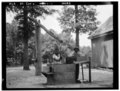 Well sweep, Cliatt Plantation
 -
 Old mule gin house, Cliatt Plantation


References edit
- ^ "Cottonton". Geographic Names Information System. United States Geological Survey, United States Department of the Interior.
- ^ "GeoHack - Cottonton, Alabama".
- ^ Climate Summary for Cottonton, Alabama
- ^ United States Postal Service (2012). "USPS - Look Up a ZIP Code". Retrieved February 15, 2012.
This Russell County, Alabama state location article is a stub. You can help Wikipedia by expanding it. |