17°36′49″N 121°41′29″E / 17.61361°N 121.69139°E
Buntun Bridge | |
|---|---|
 | |
| Coordinates | 17°36′49″N 121°41′29″E / 17.6136°N 121.6914°E |
| Carries | 2 lanes of |
| Crosses | Cagayan River |
| Locale | Tuguegarao City, Cagayan (North) Solana, Cagayan (South) |
| Official name | Buntun Bridge |
| Other name(s) | Talletay ta Buntun |
| Maintained by | Department of Public Works and Highways – Cagayan 3rd District Engineering Office |
| Characteristics | |
| Design | Steel truss bridge[1] |
| Material | Steel, Concrete, Asphalt |
| Total length | 1,369 m (4,491 ft)[a] |
| Width | 9.60 m (31 ft)[2] |
| Height | 37 m (121 ft) |
| No. of spans | 14 |
| Load limit | 18 t (18,000 kg) |
| Clearance above | 6 m (20 ft) |
| History | |
| Constructed by | Philippine National Construction Corporation |
| Construction start | December 11, 1960[1] |
| Construction end | May 10, 1969 |
| Opened | June 1, 1969 |
| Statistics | |
| Toll | No |
| Location | |
 | |
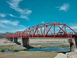
Buntun Bridge (Itawit: Talletay ta Buntun; Ilocano: Rangtáy ti Buntun; Filipino: Tulay ng Buntun) is a river bridge that stretches from Tuguegarao City to Solana in Cagayan and spans the Cagayan River, the largest river basin in the Philippines.[3] It forms part of the Santiago–Tuguegarao Road (designated as N51 by the Department of Public Works and Highways highway routing system), a major junction of the Pan-Philippine Highway. It was the longest bridge in the Philippines upon its opening in 1969, surpassed in 1973 by the San Juanico Bridge.
A popular belief is that the bridge is long enough for a person to recite the entire Philippine National Anthem while traversing.[4]
History
editIn 1959, President Carlos P. Garcia released ₱200,000 to start the construction of the bridge. The meager amount was augmented in several appropriations embodied in different Republic Acts through the initiative of Cagayan's 2nd District Congressman Benjamin Ligot. The ground-breaking ceremony on December 11, 1960, was attended by President Garcia.[1]
Construction
editThe construction was based from the original plan of ten 240-foot (73 m) steel through truss spans and one 50-foot (15 m) I-beam approach on each end. With the initial ₱200,000, Angeleo Alonzo, the first District Engineer of Department of Public Works, Transportation and Communications 2nd Cagayan Engineering District, completed Abutment A. Pier I, footing and pedestal of Pier II.
In 1962, however, Diosdado Macapagal took over as President and no one knew whether or not he would continue the project. Congressman Ligot convinced the President to continue the project under one AGUID Construction Company. The frequent floods have widened the river channel and caused the change of plan for the bridge to 14 240-foot (73 m) Japanese steel through truss spans and one 50-foot (15 m) I-beam approach on the Solana side.
President Ferdinand Marcos ordered Public Works, Transportation and Communications Secretary Antonio Raquiza to assign the bureau's construction team led by Engineer Rogelio Talastas to Buntun Bridge. The team, under Alonzo's general supervision, went to work in full swing in May 1968.
By May 10 the following year, the bridge was practically completed. However, the construction team was transferred to another project, leaving Alonzo to complete the painting of the landmark structure and the construction of the grouted riprap and the road approaches.[1]
First Lady Imelda Marcos opened the bridge to vehicular traffic on June 1, 1969, which took three administrations to build.[1]
Features
editBuntun Bridge serves as the gateway to the Cagayan's provincial capital, Tuguegarao City and links to the second and third district municipalities of Cagayan and Apayao.[5] The road infrastructure measures 1,369 m (4,491 ft),[a] considered the longest river bridge in the Philippines. It has 14 Japanese steel spans. The bridge offers an unobstructed, picturesque view of the Cagayan River,[6] the widest and longest river in the country.
See also
editNotes
editReferences
edit- ^ a b c d e De Yro, Benjie (October 29, 2016). "Buntun, the bridge 3 presidents built". The Northern Forum. Retrieved October 29, 2016.
- ^ "Road and Bridge Inventory". Department of Public Works and Highways. Retrieved March 6, 2022.
- ^ "Buntun Bridge". lakbaypinas.ph. Archived from the original on April 16, 2013. Retrieved January 27, 2022.
- ^ "Buntun Bridge, the longest river bridge in the Philippines". www.dangerousroads.org.
- ^ "Buntun Bridge – Tuguegarao City | Out and About – DiscoverPh.com". Archived from the original on June 16, 2012. Retrieved November 17, 2012.
- ^ "Longest in the Philippines". Archived from the original on November 27, 2012. Retrieved November 19, 2012.
External links
edit- Media related to Buntun Bridge at Wikimedia Commons