Barringun is a rural locality in the Shire of Paroo, Queensland, Australia.[2] It is on the border of Queensland and New South Wales.[3] In the 2016 census, Barringun had a population of 7 people.[1]
| Barringun Queensland | |||||||||||||||
|---|---|---|---|---|---|---|---|---|---|---|---|---|---|---|---|
 Barringun | |||||||||||||||
| Coordinates | 28°51′41″S 145°47′32″E / 28.8613°S 145.7922°E | ||||||||||||||
| Population | 7 (2016 census)[1] | ||||||||||||||
| • Density | 0.0075/km2 (0.0194/sq mi) | ||||||||||||||
| Postcode(s) | 4490 | ||||||||||||||
| Area | 932.8 km2 (360.2 sq mi) | ||||||||||||||
| Time zone | AEST (UTC+10:00) | ||||||||||||||
| Location |
| ||||||||||||||
| LGA(s) | Shire of Paroo | ||||||||||||||
| State electorate(s) | Warrego | ||||||||||||||
| Federal division(s) | Maranoa | ||||||||||||||
| |||||||||||||||
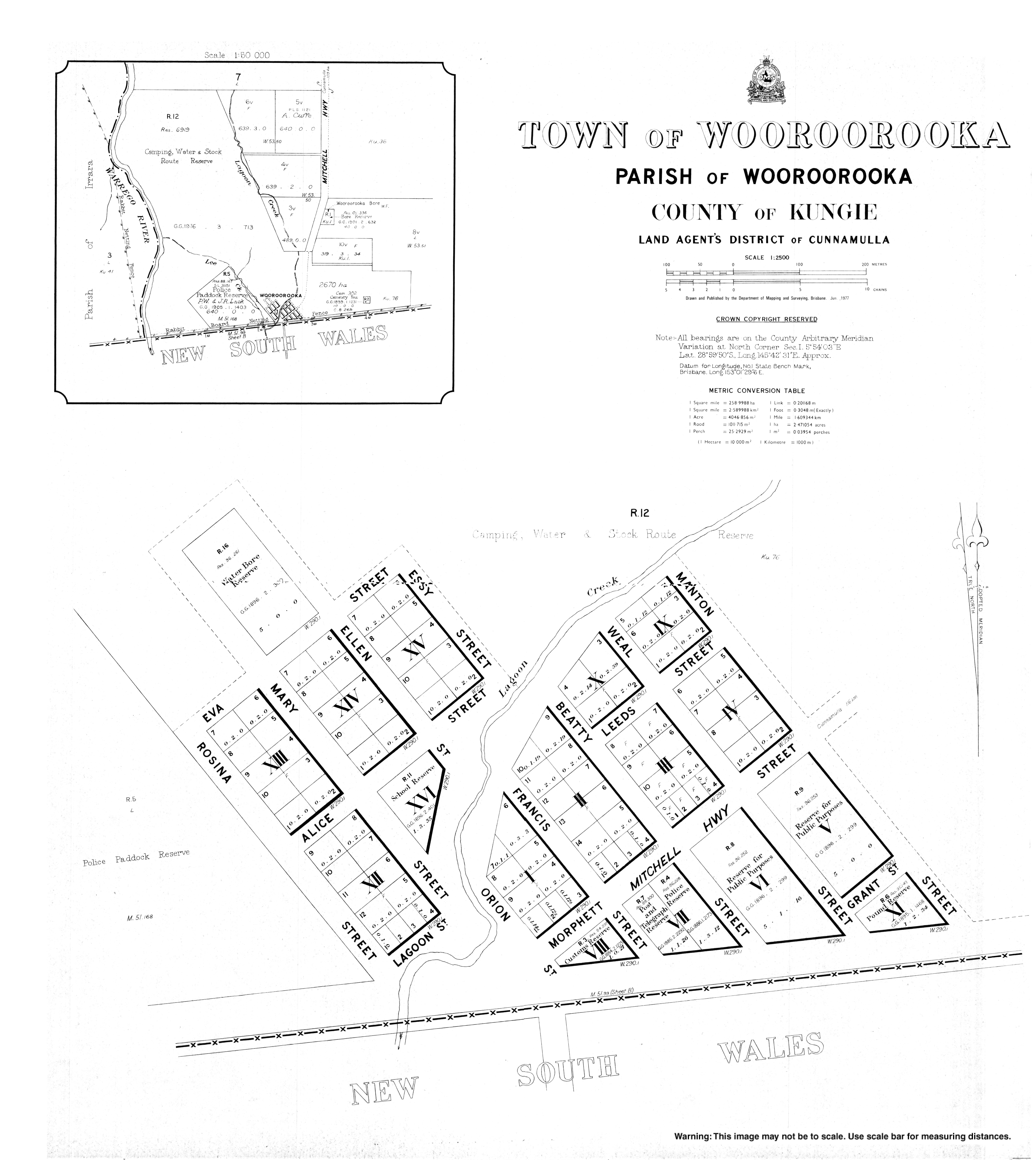
The former border town of Wooroorooka is within the south-west of the locality (28°58′00″S 145°42′00″E / 28.9667°S 145.7000°E).[4]
Geography edit
Barringun is bounded to the west by the Warrego River and to the south by the border with New South Wales.[3] The Zero Obelisk marks the first official survey of the border between what were then the separate colonies of New South Wales and Queensland when an accurate definition of the border was important for legal and economic reasons. It illustrates a remarkable feat of surveying in the nineteenth century and is a reminder of the extraordinarily difficult conditions under which many early surveyors worked.[5]
Barringun Road enters the locality from the north (Tuen) and exits to the south (Barringun, New South Wales). It is part of the Mitchell Highway that connects Cunnamulla, Queensland to Bourke, New South Wales.[3]
The principal land use is grazing on native vegetation.[3]
Binya National Park is to the immediate west of the locality in Cuttaburra.[3]
Barringun is also the capital of the self-proclaimed Murrawarri Republic.[6]
Wooroorooka is located immediately north of the border with New South Wales and is on the Owangowan Creek; it is now abandoned.[3]
History edit
_Customs_Quarters,_1885.jpg)
The name Barringun is derived from the local Aboriginal word for the lower part of the Warrego River variously transcribed as Barronga, Burringun or Barrongun. The 1859 exploration of the river from its junction with the Darling River by Matthew De Rinzy showed that Aboriginal people lived at all the waterholes along the lower reaches of this river. They were also combative to the European incursion, with De Rinzy being wounded by a spear during one of the skirmishes on his journey.[7][8]
An early British settlement (possibly a pastoral station) on the Warrego River was named Barringun, which can be seen on an 1887 map as being just south of the New South Wales border. Barringun is also possibly an Aboriginal word meaning fish die in the water.[2]
The name Wooroorooka appears to have come from a pastoral run which was owned by Mr Dangar in 1865 but was purchased in 1866 by James Tyson, who also purchased other runs in the area: Rottenrow, Gordonsheet and Teckulman.[9]
In June 1884, the Queensland Government sold approximately 100 town lots in Wooroorooka.[10]
In 1885, discussions were being held between the New South Wales and Queensland colonial parliaments about a rabbit-proof fence to prevent the spread of the pest.[11][12]
From 1885 when the railway was constructed to Bourke in New South Wales, farmers in south-western Queensland began to send their wool to markets via Bourke rather than the Charleville, then the terminus of the Western railway line in Queensland, as the New South Wales Government offered more competitive rail freight rates than the Queensland Government. Queensland Railway Commissioner James Thallon responded by negotiating with the Carrier's Union which carried goods to the Charleville railhead to make the cost of transporting the goods via Charleville more attractive. However, strikes by the carriers in support of the 1891 Australian shearers' strike meant that goods continued to be travel via New South Wales, further encouraged by new lower freight rates in New South Wales announced in June 1893. The Queensland Government responded the following month by introducing the Railway Border Tax Act which taxed wool and sheepskins crossing the border into New South Wales to make it too expensive to freight the wool via New South Wales.[13] However, this could only be a temporary measure as the anticipated Federation of Australia was expected to introduce free trade between the states of Australia removing the ability to tax goods at the border crossing. Therefore, on 3 December 1895, the Queensland Parliament approved the construction of the 121-mile (195 km) extension of the Western railway line from Charleville to Cunnamulla.[14] It was opened on 10 October 1898.[15]
A magistrate court operated in Wooroorooka from 12 June 1891 to 11 May 1944.[16]
Until the Federation of Australia in January 1901, Wooroorooka served as the Colony of Queensland border customs office, and across the border, Barringun was the Colony of New South Wales border customs office.[17] At this time, Wooroorooka had one customs officer, three police officers, a school teacher, and a post master.[18] The Wooroorooka customs house, a cottage raised up on stumps, became the Border fence ranger's residence.
Wooroorooka had a police station.[18] Barringun existed to support the surrounding pastoral property needs, and the shearing season provided important employment.[19] The local creek was able to support the town even during periods of low rainfall. Recreational activities including fishing on the Maranoa River and cricket with the nearby Belalie Station.[18]
The 1930s continued the town's interest in sports including horse races.[20][21]
A rail line from Bourke to Barringun was proposed in the late 1920s to the 1940s, to eventually connect with Cunnamulla for freight.[22][23][24] The Queensland Government opposed the New South Wales initiative as it would draw trade (and state revenue) away from the south-west Queensland area.
The road to the New South Wales border from Cunnamulla was sealed in bitumen by 1952.[25] The road was considered part of the 'death knell' to the rail line proposal.[26] The Barringun–Bourke section of the Mitchell Highway was expected to be bitumen sealed by 1971.[27]
Some properties in the area included Rostella,[28] Winrae,[29] Tinnenburra, Thurulgoona,[30] Owengowan,[31] and Amenda.[32]
In the 2016 census, Barringun had a population of 7 people.[1]
During 2020 and 2021, the Queensland border was closed due to the COVID-19 pandemic. Some border crossing points had Queensland Police checkpoints to confirm eligibility to enter Queensland, while other border crossing points were closed. At Barrigun, there was a police border checkpoint on the Mitchell Highway.[33][34]
Heritage listing edit

Barringun has a heritage-listed site on the east bank of the Warrego River at the border with New South Wales. The Zero Obelisk marks the beginning of the first official survey of the border between the two colonies.[35]
Education edit
There are no schools in Barringun. The nearest primary and secondary schools are in Cunnamulla, approximately 107 kilometres (66 mi) away. Distance education and boarding schools are the alternatives.[36]
Writings edit
The former town was the subject of a 1917 eight-verse poem of the same name by Scottish-Australian poet and bush balladeer Will H. Ogilvie (1869–1963).[37]
- The sandhills north of Barringun stand shimmering in the heat,
- The dust is driven dense and dun by forty thousand feet,
- And dimly through the clouds that cling, beyond the Border Gate,
- The kelpies swing along the wing to keep the leaders straight.
- And I remember Barringun of thirty years ago
- A few tin roofs that took the sun as white as driven snow;
- Two bush hotels where loafers sat, a butcher's shop, a store,
- A few goats feeding on the flat – and very little more!
Working on the Belalie property, to the south near Enngonia, in the early 1890s Ogilvie was familiar with the New South Wales–Queensland border area.[27]
The poem Comrades, from his anthology The Australian, and other verses (1916), also made reference to Barringun:[38]
- Do the shearers still go riding up the Warrego to work.
- Where the Thurulgoona woolshed flashes silver in the sun?
- Are the bullock-teams still bending through the cooiibahs to Bourke?
- Is there racing at Enngonia? Is Belalie still a run?
- Do the Diamantina cattle still come down by Barringun?
Ogilvie also wrote a short story about the mail run to the town entitled His Majesty's mail (1922).[39]
References edit
- ^ a b c Australian Bureau of Statistics (27 June 2017). "Barringun (SSC)". 2016 Census QuickStats. Retrieved 20 October 2018.
- ^ a b "Barringun – locality in Shire of Paroo (entry 42650)". Queensland Place Names. Queensland Government. Retrieved 5 November 2019.
- ^ a b c d e f "Queensland Globe". State of Queensland. Retrieved 13 May 2020.
- ^ "Wooroorooka – unbounded locality in Shire of Paroo (entry 38136)". Queensland Place Names. Queensland Government. Retrieved 13 May 2020.
- ^ "Zero Obelisk East Bank, Warrego River, Barringun". Queensland Government Heritage Register. Retrieved 18 April 2023.
- ^ "Murrawarri people take sovereignty campaign to UN". www.sbs.com.au. Archived from the original on 12 May 2013. Retrieved 12 May 2013.
- ^ "AUSTRALIAN EXPLORATION". The Moreton Bay Courier. Vol. XV, no. 892. Queensland, Australia. 14 July 1860. p. 5. Retrieved 15 July 2023 – via National Library of Australia.
- ^ "AUSTRALIAN EXPLORATION". The Age. No. 1, 777. Victoria, Australia. 4 July 1860. p. 5. Retrieved 15 July 2023 – via National Library of Australia.
- ^ "THE NECESSARIES OF LIFE". The Queenslander. Queensland, Australia. 30 May 1868. p. 11. Archived from the original on 24 January 2022. Retrieved 14 May 2020 – via Trove.
- ^ "Classified Advertising". The Queenslander. Queensland, Australia. 28 June 1884. p. 1021. Archived from the original on 24 January 2022. Retrieved 14 May 2020 – via Trove.
- ^ "New South Wales". Morning Bulletin. Vol. XXXIV, no. 5377. Queensland, Australia. 7 August 1885. p. 5. Archived from the original on 24 January 2022. Retrieved 31 January 2018 – via National Library of Australia.
- ^ "Intercolonial". Morning Bulletin. Vol. XXXVIII, no. 6902. Queensland, Australia. 1 June 1887. p. 6. Archived from the original on 24 January 2022. Retrieved 31 January 2018 – via National Library of Australia.
- ^ "PARLIAMENT". The Week (Brisbane). Vol. XXXVI, no. 918. Queensland, Australia. 28 July 1893. p. 9. Archived from the original on 24 January 2022. Retrieved 24 July 2019 – via National Library of Australia.
- ^ "PARLIAMENT". The Telegraph. No. 7, 217. Queensland, Australia. 4 December 1895. p. 6. Archived from the original on 24 January 2022. Retrieved 24 July 2019 – via National Library of Australia.
- ^ Kerr, John (1990), Triumph of narrow gauge : a history of Queensland Railways, Boolarong Publications, pp. 81–82, ISBN 978-0-86439-102-5
- ^ "Agency ID 2138, Court of Petty Sessions, Wooroorooka". Queensland State Archives. Retrieved 14 May 2020.
- ^ "Old-time custom centres". The Brisbane Courier. No. 20, 588. Queensland, Australia. 17 January 1924. p. 10. Archived from the original on 24 January 2022. Retrieved 1 July 2018 – via National Library of Australia.
- ^ a b c "Barringun". Wellington Times. No. 2063. New South Wales, Australia. 8 April 1909. p. 2. Archived from the original on 24 January 2022. Retrieved 31 January 2018 – via National Library of Australia.
- ^ "Barringun". Western Herald. Vol. III, no. 201. New South Wales, Australia. 18 September 1889. p. 2. Archived from the original on 12 June 2022. Retrieved 31 January 2018 – via National Library of Australia.
- ^ "Barringun sports". Western Herald. No. 1149. New South Wales, Australia. 8 April 1930. p. 2. Archived from the original on 12 June 2022. Retrieved 31 January 2018 – via National Library of Australia.
- ^ "Barringun sports". Western Herald. No. 1273. New South Wales, Australia. 10 July 1931. p. 2. Archived from the original on 12 June 2022. Retrieved 31 January 2018 – via National Library of Australia.
- ^ "Bourke-Barringun Railway". Western Herald. New South Wales, Australia. 26 June 1936. p. 3. Archived from the original on 12 June 2022. Retrieved 31 January 2018 – via National Library of Australia.
- ^ "Bourke Barringun Railway". Western Herald. New South Wales, Australia. 31 May 1946. p. 3. Archived from the original on 12 June 2022. Retrieved 31 January 2018 – via National Library of Australia.
- ^ "Bourke to Barringun". Gilgandra Weekly. New South Wales, Australia. 17 March 1949. p. 7. Archived from the original on 12 June 2022. Retrieved 31 January 2018 – via National Library of Australia.
- ^ "Border link". The Courier-Mail. No. 4967. Queensland, Australia. 29 October 1952. p. 1. Archived from the original on 12 June 2022. Retrieved 31 January 2018 – via National Library of Australia.
- ^ "Death Knell Of Railway?". Queensland Country Life. Vol. 12, no. 20. Queensland, Australia. 28 November 1946. p. 9. Archived from the original on 12 June 2022. Retrieved 31 January 2018 – via National Library of Australia.
- ^ a b "As it is today". Western Herald. New South Wales, Australia. 28 August 1970. p. 24 (Enngonia Centenary Supplement). Archived from the original on 12 June 2022. Retrieved 31 January 2018 – via National Library of Australia.
- ^ "Obituary". Western Herald. New South Wales, Australia. 6 October 1939. p. 4. Archived from the original on 12 June 2022. Retrieved 31 January 2018 – via National Library of Australia.
- ^ "The White Rose Orchestra Dance". Western Herald. New South Wales, Australia. 6 March 1959. p. 11. Archived from the original on 12 June 2022. Retrieved 31 January 2018 – via National Library of Australia.
- ^ "Stock and property movements". Queensland Country Life. Vol. 1, no. 4. Queensland, Australia. 15 August 1935. p. 13. Archived from the original on 12 June 2022. Retrieved 31 January 2018 – via National Library of Australia.
- ^ "Plane crash near Barringun". Western Herald. New South Wales, Australia. 12 October 1956. p. 1. Archived from the original on 12 June 2022. Retrieved 31 January 2018 – via National Library of Australia.
- ^ "South-Western District". Worker. Vol. 64, no. 3448. Queensland, Australia. 17 August 1953. p. 8. Archived from the original on 12 June 2022. Retrieved 3 September 2018 – via National Library of Australia.
- ^ "Road Status Update for South West". Department of Transport and Main Roads. 19 December 2021. Archived from the original on 18 December 2021. Retrieved 19 December 2021.
{{cite web}}: CS1 maint: unfit URL (link) - ^ "Queensland border restrictions in South West". South West. Queensland Police. 3 April 2020. Archived from the original on 18 December 2021. Retrieved 18 December 2021.
{{cite web}}: CS1 maint: unfit URL (link) - ^ "Zero Obelisk (entry 600763)". Queensland Heritage Register. Queensland Heritage Council. Retrieved 12 July 2013.
- ^ "Queensland Globe". State of Queensland. Retrieved 18 April 2019.
- ^ "Gates of the back country". The Land. Vol. XXII, no. 1110. New South Wales, Australia. 30 September 1932. p. 24. Archived from the original on 12 June 2022. Retrieved 31 January 2018 – via National Library of Australia.
- ^ "Australian Poems". The World's News. No. 1134. New South Wales, Australia. 8 September 1923. p. 19. Archived from the original on 12 June 2022. Retrieved 31 January 2018 – via National Library of Australia.
- ^ "His Majesty's Mails". The World's News. No. 1083. New South Wales, Australia. 16 September 1922. p. 19. Archived from the original on 12 June 2022. Retrieved 31 January 2018 – via National Library of Australia.
External links edit
- "Town or Wooroorooka" (Map). Queensland Government. 1977. Archived from the original on 14 May 2020.