Barbour County is a county in north central West Virginia, United States. At the 2020 census, the population was 15,465.[5] The county seat is Philippi,[6] which was chartered in 1844. Both county and city were named for Philip P. Barbour (1783–1841), a U.S. Congressman from Virginia and Associate Justice of the U.S. Supreme Court. The county was formed in 1843[7] when the region was still part of the state of Virginia. In 1871, a small part of Barbour County was transferred to Tucker County, West Virginia.
Barbour County | |
|---|---|
 Flag | |
 Location of Barbour County in West Virginia | |
 West Virginia's location within the U.S. | |
| Coordinates: 39°08′N 80°00′W / 39.13°N 80°W | |
| Country | |
| State | |
| Founded | March 3, 1843 |
| Named for | Philip P. Barbour |
| Seat | Philippi |
| and largest city | |
| Government | |
| • County Administrator | Shana Frey [1] |
| • County Commission | David Strait (R)[2] Jamie Carpenter (R)[3] Jedd Schola (R)[4] |
| Area | |
| • Total | 888.0 km2 (342.85 sq mi) |
| • Land | 883.3 km2 (341.06 sq mi) |
| • Water | 4.6 km2 (1.79 sq mi) 0.5% |
| • Rank | 37th |
| Population (2020) | |
| • Total | 15,465 |
| • Estimate (2021) | 15,468 |
| • Rank | 36th |
| • Density | 17/km2 (45/sq mi) |
| Time zone | UTC−5 (Eastern) |
| • Summer (DST) | UTC−4 (EDT) |
| Area code(s) | 304, 681 |
| Congressional district | 2nd |
| Senate district | 11th |
| House of Delegates district | 68th |
| Website | https://barbourcountywv.org/ |


The Battle of Philippi, also known as the "Philippi Races", was fought in Barbour County on June 3, 1861. Although a minor action, it is generally considered the first land engagement of the American Civil War.
For 114 years (1909-2023), Barbour County was home to Alderson-Broaddus College (later Alderson Broaddus University), an American Baptist institution. Its four-year Physician Assistant (PA) baccalaureate program was the first such anywhere.
History edit
Settlement and formation edit
The first white settlement in present-day Barbour County was established in 1780 by Richard Talbott – along with his brother Cotteral and sister Charity – about three miles (4.8 km) downriver from the future site of Philippi.[8] At this time the region was still a part of Monongalia County, Virginia. The region had had no permanent Indian settlements and so conflicts with Native Americans were relatively infrequent in the early days. Nevertheless, the Talbotts were obliged to leave their homestead several times for safety and twice found it necessary to retreat back east of the Alleghenies, returning each time. No member of this eventually large family was ever killed by Indian attacks.[9]
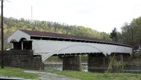
Over time, parts of the future Barbour County were included in the newly created Harrison (1784), Randolph (1787), and Lewis (1816) Counties. Barbour County itself was created in 1843 and named for the late Virginia politician and jurist Philip P. Barbour (1783–1841). (Barbour had served as a U.S. Congressman from Virginia, Speaker of the House, and Associate Justice of the United States Supreme Court.) The settlement of Philippi – formerly "Anglin's Ford" and "Booth's Ferry" – was platted, named, and made the county seat in the same year; it was chartered in 1844. By the 1850s, when a major covered bridge was constructed at Philippi to service travellers on the Beverly-Fairmont Turnpike, the county's population was approaching 10,000 people.
The first newspaper in the county was the Barbour Jeffersonian, published starting in August 1857 and running only to about June 1861. It was put out by Thompson Surghnor (1820-1864).[10]
Civil War edit
In April 1861, an Ordinance of Secession from the United States of America was approved throughout the state of Virginia in a referendum. Delegates from 25 western counties, however, assembled at Wheeling on 13 May for the first of a two meetings (see Wheeling Convention) called to repeal the Ordinance. The delegates from Barbour County for the first convention were Spencer Dayton, John H. Shuttleworth, and E.H. Manafee. Barbour County had voted in favor of Virginia's secession, though, and a palmetto secession flag had been flying above the courthouse since January, 1861.[11]
On 3 June 1861, Philippi was the scene of one of the first battles of the American Civil War. The battle was later lampooned as the "Philippi Races" because of the hurried retreat by the Confederate troops encamped in the town. (The skirmish is reenacted every June during the town's "Blue and Gray Reunion".) At daylight on June 3, two columns of Union forces under the command of Col. Benjamin Franklin Kelley and Col. Ebenezer Dumont, with perhaps 3,000 men, arrived from Grafton and attacked about 800 poorly armed Confederate recruits under the command of Col. George A. Porterfield. The Union troops had marched all night through a heavy rain storm to arrive just before daylight. The surprise attack awakened the sleeping Confederates. After firing a few shots at the advancing Union troops, the Southerners broke lines and began running frantically to the south, some still in their bed clothes.
The Union victory in a relatively bloodless battle propelled the young Major General George B. McClellan into the national spotlight, and he would soon be given command of all Union armies. The battle also inspired more vocal protests in the Western part of Virginia against secession. On 11 June, the second Wheeling Convention met in that city and Barbour County was again represented by Dayton and Shuttleworth, who were this time joined by N.H. Taft. The Convention nullified the Virginia Ordinance of Secession and named Francis H. Pierpont governor. These events would eventually result in the separate statehood of West Virginia.
Later history edit
The economy and infrastructure in Barbour grew steadily, but slowly, through the late 19th century. Although the first railroad had reached nearby Grafton in 1852, a narrow-gauge railroad was not laid through the county until the early 1880s; a standard gauge line followed in the 1890s.
In 1990, private developers offered Barbour County citizens $4M to $6M annually in host fees to accept out-of-state garbage into a County landfill over the following three decades. Up to 200,000 tons of garbage per month would be delivered.[12] (At the time, the county's annual budget was only about $1M.) County voters rejected the offer.[13]
In 2023, Barbour County lost its major employer when Alderson-Broaddus University's board of trustees voted to close the institution some 152 years after its founding.[14]
Registered Historic Places edit
|
|
Geography edit
According to the United States Census Bureau, the county has a total area of 343 square miles (890 km2), of which 341 square miles (880 km2) is land and 1.8 square miles (4.7 km2) (0.5%) is water.[15]
Barbour County is situated on the Allegheny Plateau at the western edge of the Allegheny Mountains (represented by Laurel Mountain at the county's eastern boundary). Most of the county is drained by the Tygart Valley River which traverses it from south to north and on which its three largest settlements – Philippi, Belington, and Junior – are sited. Tributaries of the Tygart in the County include Teter Creek, Laurel Creek, Hacker's Creek, the Buckhannon River and the West Fork River. A portion of the County in the west drains into the Middle Fork River, principally through Elk Creek. Audra State Park – the county's only state park – is situated on the Middle Fork in the southwest corner. Teter Creek Lake Wildlife Management Area – the county's only WMA – is located on that stream and lake in the eastern portion. All of the mentioned streams are part of the greater Monongahela River watershed.
Major highways edit |
Adjacent counties edit
|
Demographics edit
| Census | Pop. | Note | %± |
|---|---|---|---|
| 1850 | 9,005 | — | |
| 1860 | 8,958 | −0.5% | |
| 1870 | 10,312 | 15.1% | |
| 1880 | 11,870 | 15.1% | |
| 1890 | 12,702 | 7.0% | |
| 1900 | 14,198 | 11.8% | |
| 1910 | 15,858 | 11.7% | |
| 1920 | 18,028 | 13.7% | |
| 1930 | 18,628 | 3.3% | |
| 1940 | 19,869 | 6.7% | |
| 1950 | 19,745 | −0.6% | |
| 1960 | 15,474 | −21.6% | |
| 1970 | 14,030 | −9.3% | |
| 1980 | 16,639 | 18.6% | |
| 1990 | 15,699 | −5.6% | |
| 2000 | 15,557 | −0.9% | |
| 2010 | 16,589 | 6.6% | |
| 2020 | 15,465 | −6.8% | |
| 2021 (est.) | 15,468 | [16] | 0.0% |
| U.S. Decennial Census[17] 1790–1960[18] 1900–1990[19] 1990–2000[20] 2010–2020[5] | |||
2020 census edit
As of the 2020 census, there were 15,465 people and 5,813 households residing in the county. There were 7,114 housing units in Barbour. The racial makeup of the county was 93.5% White, 1.8% African American, 0.2% Asian, 0.2% Native American, 0.3% from other races, and 4% from two or more races. Hispanics or Latinos of any race were 1.2% of the population.
Of the 5,813 households, 47.5% were married couples living together, 25.5% had a female householder with no spouse present, 18.4% had a male householder with no spouse present. The average household and family size was 3.22. The median age in the county was 42.7 years with 20.5% of the population under 18. The median income for a household was $42,260 and the poverty rate was 20.8%.[21]
2010 census edit
As of the 2010 United States census, there were 16,589 people, 6,548 households, and 4,643 families residing in the county.[22] The population density was 48.6 inhabitants per square mile (18.8/km2). There were 7,849 housing units at an average density of 23.0 per square mile (8.9/km2).[23] The racial makeup of the county was 96.8% white, 0.7% black or African American, 0.6% American Indian, 0.2% Asian, 0.2% from other races, and 1.5% from two or more races. Those of Hispanic or Latino origin made up 0.6% of the population.[22] In terms of ancestry, 23.4% were German, 22.3% were American, 13.6% were Irish, and 11.0% were English.[24]
Of the 6,548 households, 30.7% had children under the age of 18 living with them, 54.8% were married couples living together, 10.9% had a female householder with no husband present, 29.1% were non-families, and 24.2% of all households were made up of individuals. The average household size was 2.46 and the average family size was 2.89. The median age was 41.5 years.[22]
The median income for a household in the county was $31,212 and the median income for a family was $39,434. Males had a median income of $34,573 versus $21,797 for females. The per capita income for the county was $17,304. About 14.3% of families and 18.4% of the population were below the poverty line, including 27.5% of those under age 18 and 13.6% of those age 65 or over.[25]
2000 census edit
As of the census of 2000, there were 15,557 people, 6,123 households, and 4,365 families residing in the county. The population density was 46 people per square mile (18 people/km2). There were 7,348 housing units at an average density of 22 per square mile (8.5/km2). The racial makeup of the county was 97.36% White, 0.49% Black or African American, 0.71% Native American, 0.26% Asian, 0.02% Pacific Islander, 0.12% from other races, and 1.03% from two or more races. 0.47% of the population were Hispanic or Latino of any race. In addition, the area has a significant population of racially mixed (though often light-skinned and blue-eyed) people, known locally as 'the Chestnut Ridge people', whose specific origins are uncertain. They are categorized by many scholars among the Melungeons found scattered throughout Appalachia.
There were 6,123 households, out of which 30.10% had children under the age of 18 living with them, 57.20% were married couples living together, 10.30% had a female householder with no husband present, and 28.70% were non-families. 25.10% of all households were made up of individuals, and 12.60% had someone living alone who was 65 years of age or older. The average household size was 2.47 and the average family size was 2.94.
In the county, the population was spread out, with 23.00% under the age of 18, 9.40% from 18 to 24, 26.80% from 25 to 44, 25.20% from 45 to 64, and 15.60% who were 65 years of age or older. The median age was 39 years. For every 100 females there were 96.70 males. For every 100 females age 18 and over, there were 92.00 males.
The median income for a household in the county was $24,729, and the median income for a family was $29,722. Males had a median income of $24,861 versus $17,433 for females. The per capita income for the county was $12,440. 22.60% of the population and 18.40% of families were below the poverty line. Out of the total population, 32.00% of those under the age of 18 and 16.70% of those 65 and older were living below the poverty line.
Politics edit
Federal Politics edit
Barbour County lies within West Virginia's 2nd congressional district. The current representative of the district is Alex Mooney (R).
Barbour County was generally split for most of the twentieth century, though it tended to vote more for the Democrats rather than the Republicans. This is due to the County's split position in the American Civil War between Unionists and Secessionists.[26] Since the 2000 Presidential Elections, Barbour County has followed the trend with the rest of the state towards the Republicans.
| Year | Republican | Democratic | Third party | |||
|---|---|---|---|---|---|---|
| No. | % | No. | % | No. | % | |
| 2020 | 5,116 | 76.62% | 1,457 | 21.82% | 104 | 1.56% |
| 2016 | 4,527 | 74.02% | 1,222 | 19.98% | 367 | 6.00% |
| 2012 | 3,824 | 66.19% | 1,768 | 30.60% | 185 | 3.20% |
| 2008 | 3,685 | 59.13% | 2,419 | 38.82% | 128 | 2.05% |
| 2004 | 4,004 | 60.17% | 2,610 | 39.22% | 41 | 0.62% |
| 2000 | 3,411 | 56.37% | 2,503 | 41.37% | 137 | 2.26% |
| 1996 | 2,155 | 35.64% | 3,076 | 50.87% | 816 | 13.49% |
| 1992 | 2,322 | 33.39% | 3,467 | 49.86% | 1,165 | 16.75% |
| 1988 | 3,023 | 48.28% | 3,221 | 51.45% | 17 | 0.27% |
| 1984 | 3,877 | 55.43% | 3,108 | 44.43% | 10 | 0.14% |
| 1980 | 3,311 | 46.73% | 3,451 | 48.70% | 324 | 4.57% |
| 1976 | 3,235 | 47.01% | 3,647 | 52.99% | 0 | 0.00% |
| 1972 | 4,432 | 66.25% | 2,258 | 33.75% | 0 | 0.00% |
| 1968 | 3,206 | 47.28% | 3,210 | 47.34% | 365 | 5.38% |
| 1964 | 2,533 | 34.74% | 4,758 | 65.26% | 0 | 0.00% |
| 1960 | 4,006 | 51.20% | 3,818 | 48.80% | 0 | 0.00% |
| 1956 | 4,460 | 54.61% | 3,707 | 45.39% | 0 | 0.00% |
| 1952 | 4,504 | 50.08% | 4,489 | 49.92% | 0 | 0.00% |
| 1948 | 3,834 | 47.33% | 4,238 | 52.32% | 28 | 0.35% |
| 1944 | 3,993 | 51.78% | 3,718 | 48.22% | 0 | 0.00% |
| 1940 | 4,576 | 47.66% | 5,025 | 52.34% | 0 | 0.00% |
| 1936 | 3,875 | 42.13% | 5,284 | 57.45% | 39 | 0.42% |
| 1932 | 3,652 | 45.52% | 4,228 | 52.71% | 142 | 1.77% |
| 1928 | 4,023 | 53.54% | 3,491 | 46.46% | 0 | 0.00% |
| 1924 | 3,347 | 45.41% | 3,188 | 43.25% | 836 | 11.34% |
| 1920 | 3,763 | 56.58% | 2,777 | 41.75% | 111 | 1.67% |
| 1916 | 2,083 | 52.23% | 1,848 | 46.34% | 57 | 1.43% |
| 1912 | 607 | 16.45% | 1,561 | 42.29% | 1,523 | 41.26% |
Economy edit
Major employment in Barbour County is provided by health care and social service sectors, retail, education, accommodation and food services, logging and wood product manufacturing, trucking and construction. The largest employers are Alderson Broaddus University and Broaddus Hospital.
Bituminous coal mining has been significant in Barbour; seven times as much tonnage has been produced from underground as by surface mining. Natural gas and oil wells provide a modest amount of employment. Wholesale lumber production (wood and wood products) is also present. (The county is a member of the West Virginia Hardwood Alliance Zone.) There is notable production of eggs and horse raising, but the major agricultural products are livestock, forage, dairy foods and orchard fruits.
Communities edit

City edit
- Philippi (county seat)
Towns edit
Census-designated places edit
Unincorporated communities edit
- Adaland
- Adma
- Arden
- Audra
- Bear Mountain
- Berryburg
- Boulder (Rangoon)
- Brownton
- Calhoun
- Carrollton
- Century Junction
- Claude
- Clemtown
- Corley
- Cove Run
- Dartmoor
- Dent
- Elk City
- Finegan Ford
- Gage
- Hall
- Hopewell
- Independence
- Jones
- Kalamazoo
- Kasson
- Kirt
- Lantz
- Longview
- Mansfield
- Meadowville
- Meriden
- Middle Fork
- Moatsville
- Mount Liberty
- Murphy
- Nestorville
- Overfield
- Peeltree
- Pepper
- Pleasure Valley
- Stringtown
- Tacy
- Talbott
- Tygart Junction
- Union
- Valley Bend
- Valley Furnace
- Vannoys Mill
- Volga
- Wellington Heights
- Werner
- West Junior
Minor civil divisions edit
In 1863, West Virginia's counties were divided into civil townships, with the intention of encouraging local government. This proved impractical in the heavily rural state, and in 1872 the townships were converted into magisterial districts.[28] Barbour County's original magisterial districts were Barker, Cove, Elk, Glade, Philippi, Pleasant, and Union. Between 1880 and 1890, part of Barker District was split off to form Valley District. These eight districts continued until the 1970s, when they were consolidated into three districts: North, South, and West.[29]
The names and boundaries of Barbour county's historic magisterial districts were preserved as assessment and tax districts, alongside the corporations of Belington, Junior, and Philippi. The City of Philippi is divided into four wards, all of which are in Philippi District. The first and second wards of Belington are in Valley District, while the second and third ward are in Barker District.
Notable natives and residents edit
- Ann Maria Reeves Jarvis (1832–1905), social activist who – along with her daughter Anna Marie Jarvis (1864–1948) – is credited with founding Mother's Day, lived in the county for several years
- William Smith O'Brien (Congressman) (1862–1948), born at Audra
- Ida Lilliard Reed (1865–1951), hymn writer
- Ted Cassidy (1932–79), actor who played Lurch and "Thing" on the 1960s TV show The Addams Family
- Larry Groce (b. 1948), noted singer and songwriter, lived near Galloway in the late 1980s
See also edit
References edit
Citations edit
- ^ "Barbour County Commission". Barbour County. Retrieved November 6, 2023.
- ^ "2020 General Election Results: Barbour County". WBOY-TV. Retrieved November 6, 2023.
- ^ "Barbour County has a new commissioner; more results from Doddridge electon". WVNews. Retrieved November 6, 2023.
- ^ "Local election results for Barbour County". WBOY-TV. Retrieved November 6, 2023.(European Economic Area (EEA) including the EU 451: Unavailable due to legal reasons)
- ^ a b "State & County QuickFacts". United States Census Bureau. Retrieved August 14, 2022.
- ^ "Find a County". National Association of Counties. Archived from the original on May 31, 2011. Retrieved June 7, 2011.
- ^ "Archived copy". Archived from the original on September 23, 2001. Retrieved July 23, 2013.
{{cite web}}: CS1 maint: archived copy as title (link) - ^ The Talbotts settled at the mouth of Hacker's Creek. Maxwell, Hu (1899), The History of Barbour County, From its Earliest Exploration and Settlement to the Present Time, The Acme Publishing Company, Morgantown, W.Va. (Reprinted, McClain Printing Company, Parsons, W.Va., 1968.), pg 473.
- ^ Maxwell, Op. cit., pg 474.
- ^ Barbour County Historical Society (1979), Barbour County, West Virginia...Another Look; Taylor Publishing Company, pg 30.
- ^ Maxwell, Hu (1899). The history of Barbour County, West Virginia, from its earliest exploration and settlement to the present time. West Virginia University Libraries. Morgantown, W. Va. : Acme Publishing Company.
- ^ "Landfill Controversy Divides Barbour County" (1990), Charleston Gazette (Oct 28 issue).
- ^ "Barbour Rejecting Landfill" (1990), Charleston Gazette, (Nov 7 issue).
- ^ McCluskey, Mitchell (August 2, 2023). "Financially struggling university in West Virginia closes down, leaving students scrambling". CNN.
- ^ "2010 Census Gazetteer Files". United States Census Bureau. August 22, 2012. Retrieved July 23, 2015.
- ^ "Annual Estimates of the Resident Population for Counties: April 1, 2020 to July 1, 2021". Retrieved August 14, 2022.
- ^ "U.S. Decennial Census". United States Census Bureau. Retrieved January 9, 2014.
- ^ "Historical Census Browser". University of Virginia Library. Retrieved January 9, 2014.
- ^ "Population of Counties by Decennial Census: 1900 to 1990". United States Census Bureau. Retrieved January 9, 2014.
- ^ "Census 2000 PHC-T-4. Ranking Tables for Counties: 1990 and 2000" (PDF). United States Census Bureau. Retrieved January 9, 2014.
- ^ "Explore Census Data". data.census.gov. Retrieved April 11, 2023.
- ^ a b c "DP-1 Profile of General Population and Housing Characteristics: 2010 Demographic Profile Data". United States Census Bureau. Archived from the original on February 13, 2020. Retrieved April 3, 2016.
- ^ "Population, Housing Units, Area, and Density: 2010 - County". United States Census Bureau. Archived from the original on February 13, 2020. Retrieved April 3, 2016.
- ^ "DP02 SELECTED SOCIAL CHARACTERISTICS IN THE UNITED STATES – 2006-2010 American Community Survey 5-Year Estimates". United States Census Bureau. Archived from the original on February 13, 2020. Retrieved April 3, 2016.
- ^ "DP03 SELECTED ECONOMIC CHARACTERISTICS – 2006-2010 American Community Survey 5-Year Estimates". United States Census Bureau. Archived from the original on February 13, 2020. Retrieved April 3, 2016.
- ^ Denton, Lawrence M.; Unionists in Virginia: Politics, Secession and Their Plan to Prevent Civil War, ISBN 1625852797
- ^ Leip, David. "Dave Leip's Atlas of U.S. Presidential Elections". uselectionatlas.org. Retrieved March 27, 2018.
- ^ Otis K. Rice & Stephen W. Brown, West Virginia: A History, 2nd ed., University Press of Kentucky, Lexington (1993), p. 240.
- ^ United States Census Bureau, U.S. Decennial Census, Tables of Minor Civil Divisions in West Virginia, 1870–2010.
Other sources edit
- Barbour County West Virginia...Another Look (1979), Compiled by The Barbour County Historical Society, Taylor Publishing Company, Dallas, TX and Paoli, PA.
- Coonts, Violet Gadd (2nd ed, May 1991), The Western Waters: Early Settlers of Eastern Barbour County, West Virginia, Assisted by Gilbert Gray Coonts and Harold Cart Gadd, Published by Stephen P. Coonts, Denver, CO.
- Coffman, Mary Stemple and Ethel Park Stemple (1978), Footsteps of Our Fathers: Early Settlers of Tacy (Barbour County) W. Va.; Baltimore.
- Hardesty's Historical and Geographical Encyclopedia, Illustrated: Containing large scale copper plate Maps of Each State and Territory of the United States, and the Provinces of Canada ... Special History of the Virginias, Maps and Histories of Lewis, Upshur and Barbour Counties, West Virginia ... Volume 4 of the series published by H.H. Hardesty, 1883, 391 pages. (Reprint edition edited by Jim Comstock; Subsequent reprint by Wes Cochran. Contains a brief history of Barbour County and biographical sketches of its citizens.)
- Mattaliano, Jane K. and Lois G. Omonde (1994), Milestones: A Pictorial History of Philippi, West Virginia, 1844–1994, Virginia Beach, Virginia: The Donning Company Publishers.
- Myers, Karl or Elmer (ca. 1935), One-Room Schoolhouses, 1 min. home movie of one-room Barbour County schoolhouses; West Virginia State Archives (Available on DVD set Treasures from American Film Archives: 50 Preserved Films, 2000).
- Shaffer, John W. (2003), Clash of Loyalties: A Border County in the Civil War, Morgantown, West Virginia: West Virginia University Press.
- Shingleton, George A. (1976), History of Mt. Morris School, Church and Cove District, Parsons, West Virginia: McClain Printing Company.
- Smith, Barbara and Carl Briggs (2000), Barbour County (Series: Images of America), Arcadia Publishing, Charleston, SC.
- Zinn, W.D. (1931), The Story of Woodbine Farm, Buckhannon, West Virginia: Kent Reger, Job Printer. (A detailed account of life and work on a Barbour County [Shooks Run] farm in the late-19th/early-20th centuries.)