Aubigny is a rural town and locality in the Toowoomba Region, Queensland, Australia.[2][3] In the 2016 census, the locality of Aubigny had a population of 254 people.[1]
| Aubigny Queensland | |||||||||||||||
|---|---|---|---|---|---|---|---|---|---|---|---|---|---|---|---|
 Fields along Oakey Crosshill Road, 2014 | |||||||||||||||
 Aubigny | |||||||||||||||
| Coordinates | 27°31′23″S 151°38′47″E / 27.5230°S 151.6463°E | ||||||||||||||
| Population | 254 (2016 census)[1] | ||||||||||||||
| • Density | 4.425/km2 (11.46/sq mi) | ||||||||||||||
| Postcode(s) | 4401 | ||||||||||||||
| Elevation | 430 m (1,411 ft) | ||||||||||||||
| Area | 57.4 km2 (22.2 sq mi) | ||||||||||||||
| Time zone | AEST (UTC+10:00) | ||||||||||||||
| Location | |||||||||||||||
| LGA(s) | Toowoomba Region | ||||||||||||||
| State electorate(s) | Condamine | ||||||||||||||
| Federal division(s) | Groom | ||||||||||||||
| |||||||||||||||
Geography edit
The former locality of Tangkam (27°28′59″S 151°40′00″E / 27.48306°S 151.66667°E) is in the northern part of Aubigny. It took its name from the Tangkam railway station (27°28′28″S 151°40′21″E / 27.4745°S 151.6725°E) on the Cecil Plains railway line. The name Tangkam is believed to be an Aboriginal word meaning sour.[4]
The Toowoomba–Cecil Plains Road runs along the southern boundary, and the Oakey-Pittsworth Road passes through from north-east to south-west.[5]
History edit

Crosshill State School opened on 9 August 1880 and closed on 1940.[6][7] It was at 317 Ciesiolka Road (27°30′33″S 151°40′57″E / 27.5093°S 151.6826°E).[8][9]
Aubigny was at the centre of the Westbrook Homestead area.
The town lots were offered for sale in the new town of Aubigny in December 1885, but only two lots were sold at that time, one to the Lutheran church and one to the Catholic church.[10]
St John's Lutheran Church opened in 1886.[11] On Sunday 22 September 1929, a new larger church was built with the 1886 church becoming the church hall.[12]
Aubigny Post Office opened around September 1907 (a receiving office had been open since 1894) and closed in 1968.[13]
Aubigny State School opened 24 January 1921 and closed about 27 October 1967.[6][14][15] It was at 1309 Oakey Pittsworth Road (27°31′13″S 151°38′44″E / 27.5204°S 151.6455°E).[16][8][9]
The town was serviced by the Cecil Plains railway line between 1915 and 1994.
Tangkam State School opened on 26 November 1918. It closed on 22 January 1961.[6] It was at 25 Brennan Road (27°28′16″S 151°40′25″E / 27.4712°S 151.6737°E).[8][9]
At the 2011 census, Aubigny had a population of 386 people.[17]
In the 2016 census, the locality of Aubigny had a population of 254 people.[1]
Education edit
There are no schools in Aubigny. The nearest government primary schools are Oakey State School in neighbouring Oakey to the north and Biddeston State School in neighbouring Biddeston to the east. The nearest government secondary school is Oakey State High School, also in Oakey.[9]
Amenities edit
St John's Lutheran Church is at 2 Aubigny Crosshill Road (27°31′19″S 151°38′34″E / 27.5220°S 151.6428°E). It is part of the Australian Evangelican Lutheran Church.[18]
References edit
- ^ a b c Australian Bureau of Statistics (27 June 2017). "Aubigny (SSC)". 2016 Census QuickStats. Retrieved 20 October 2018.
- ^ "Aubigny – town in Toowoomba Region (entry 981)". Queensland Place Names. Queensland Government. Retrieved 7 March 2022.
- ^ "Aubigny – locality in Toowoomba Region (entry 47886)". Queensland Place Names. Queensland Government. Retrieved 7 March 2022.
- ^ "Tangkam – neighbourhood (entry 33281)". Queensland Place Names. Queensland Government. Retrieved 27 January 2017.
- ^ Google (10 February 2022). "Aubigny" (Map). Google Maps. Google. Retrieved 10 February 2022.
- ^ a b c Queensland Family History Society (2010), Queensland schools past and present (Version 1.01 ed.), Queensland Family History Society, ISBN 978-1-921171-26-0
- ^ "School for Crosshill". Toowoomba Chronicle and Darling Downs General Advertiser. No. 1464. Queensland, Australia. 11 March 1879. p. 3. Retrieved 23 November 2019 – via National Library of Australia.
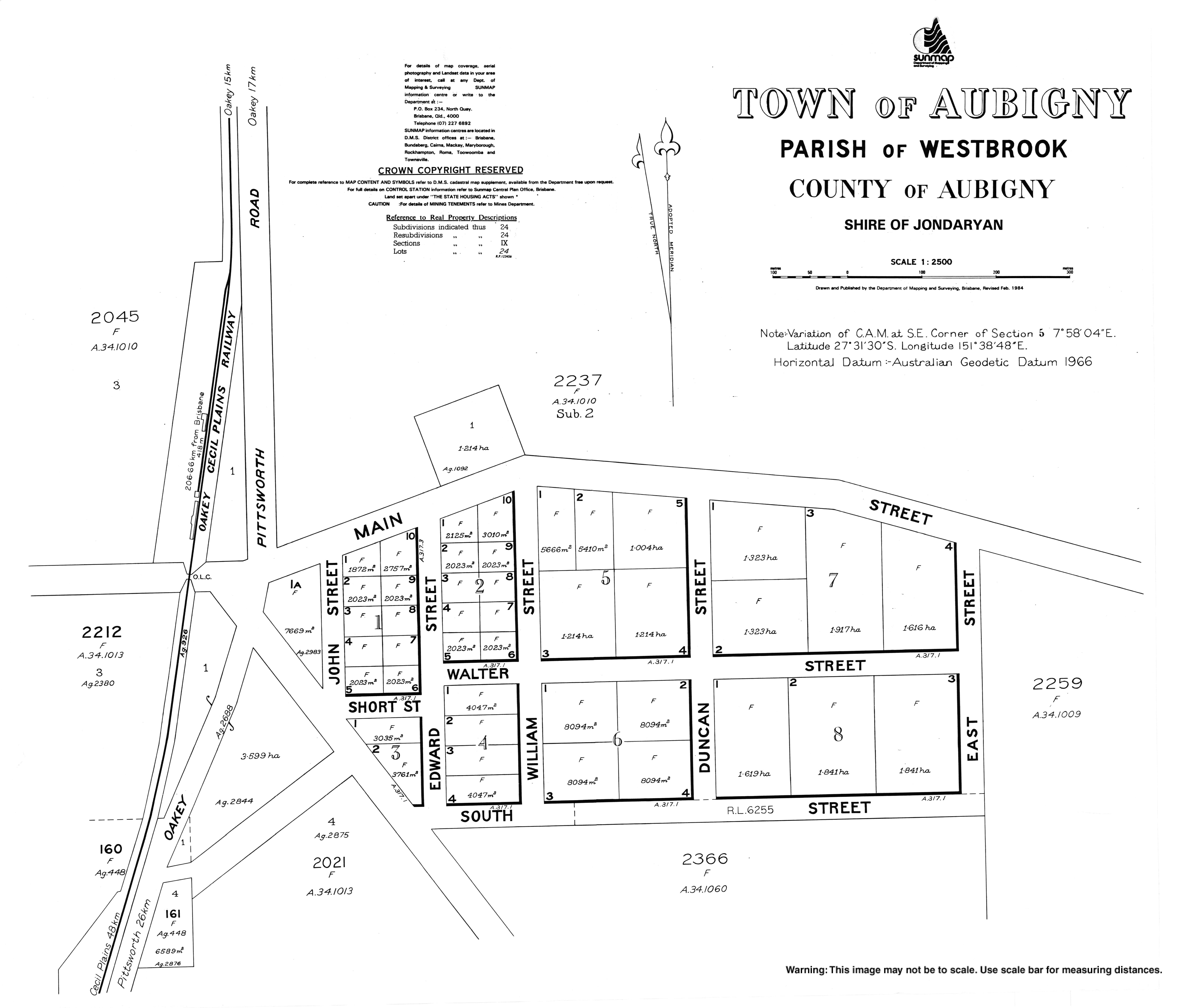
- ^ a b c "Parish of Westbrook sheet 2" (Map). Queensland Government. 1932. Archived from the original on 12 June 2022. Retrieved 12 June 2022.
- ^ a b c d "Queensland Globe". State of Queensland. Retrieved 12 June 2022.
- ^ "QUEENSLAND NEWS". The Queenslander. 26 December 1885. p. 1009. Archived from the original on 12 June 2022. Retrieved 27 October 2014 – via National Library of Australia.
- ^ St John's Lutheran Church Aubigny 1886-1986 centennial booklet : centennial celebrations 11th May, 1986, St John's Lutheran Church, 1986, archived from the original on 12 June 2022, retrieved 27 October 2014
- ^ "LUTHERAN CHURCH". Toowoomba Chronicle and Darling Downs Gazette. Vol. LXVIII, no. 232. Queensland, Australia. 28 September 1929. p. 10. Archived from the original on 12 June 2022. Retrieved 12 June 2022 – via National Library of Australia.
- ^ Phoenix Auctions History. "Post Office List". Phoenix Auctions. Archived from the original on 12 June 2022. Retrieved 14 February 2021.
- ^ "Opening and closing dates of Queensland Schools". Queensland Government. Retrieved 2 April 2014.
- ^ "Agency ID 6349, Aubigny State School". Queensland State Archives. Retrieved 3 April 2014.
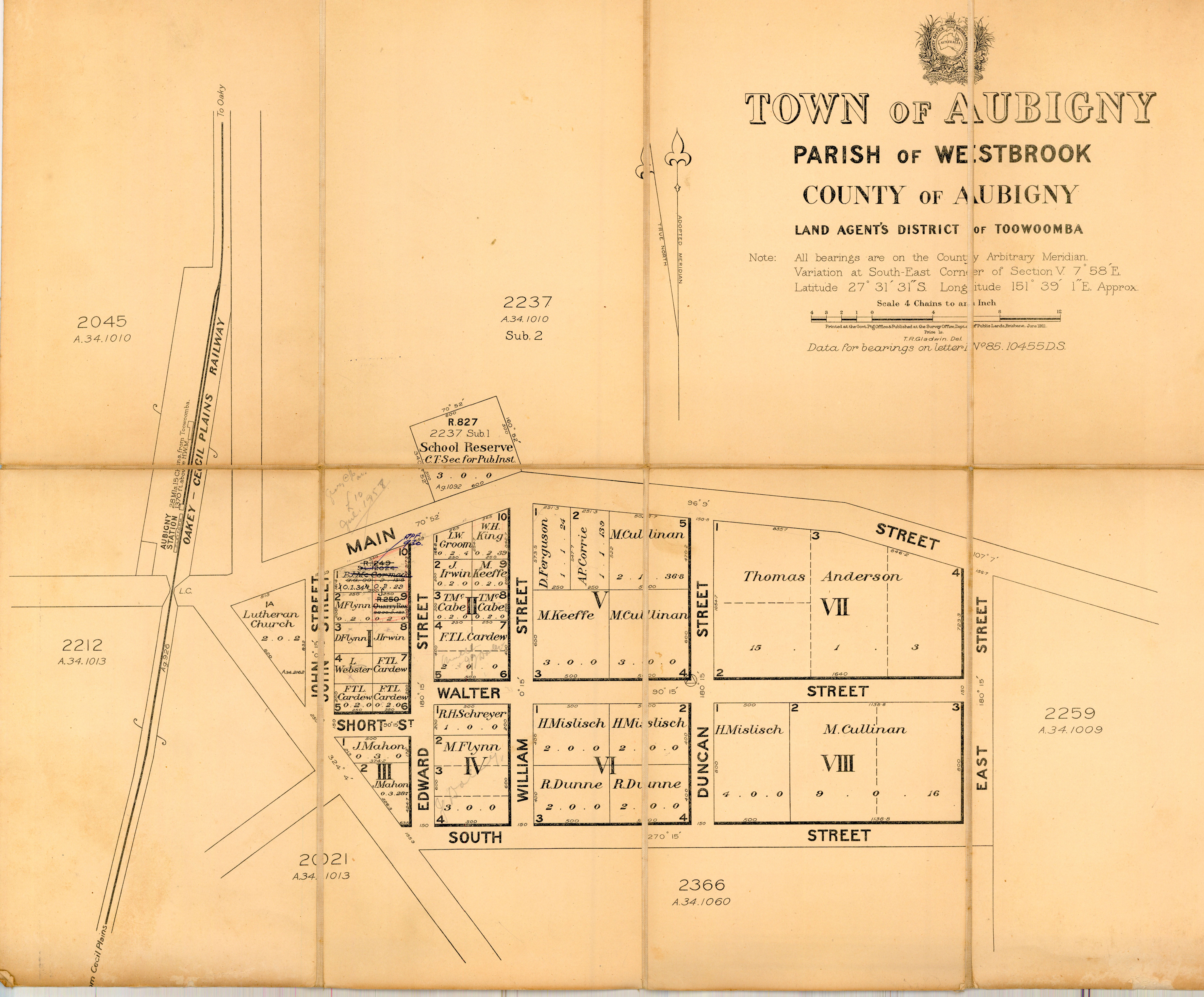
- ^ "Town of Aubigny" (Map). Queensland Government. 1921. Archived from the original on 12 June 2022. Retrieved 12 June 2022.
- ^ Australian Bureau of Statistics (31 October 2012). "Aubigny". 2011 Census QuickStats. Retrieved 2 April 2014.
- ^ "About Aubigny St John's". Australian Evangelican Lutheran Church. Archived from the original on 12 June 2022. Retrieved 12 June 2022.
Further reading edit
- Gibney, Irene Mary Therese (2000), Aubigny : my home
- Oakey State School 125th celebration : October 22, 1999, Oakey, Qld., 2003
{{citation}}: CS1 maint: location missing publisher (link) — includes Gowrie Little Plains School, Aubigny School, Crosshill School, Devon Park State School, Silverleigh State School, Boodua School, Greenwood State School, Kelvinhaugh State School
External links edit