Anguerny (French pronunciation: [ɑ̃ɡɛʁni] ⓘ) is a former commune in the Calvados department in the Normandy region of northwestern France. On 1 January 2016, it was merged into the new commune of Colomby-Anguerny.[2]
Anguerny | |
|---|---|
Part of Colomby-Anguerny | |
 Old House at Anguerny | |
 Coat of arms | |
Location of Anguerny  | |
 Anguerny  Anguerny | |
| Coordinates: 49°16′39″N 0°23′49″W / 49.2775°N 0.3969°W | |
| Country | France |
| Region | Normandy |
| Department | Calvados |
| Arrondissement | Caen |
| Canton | Courseulles-sur-Mer |
| Commune | Colomby-Anguerny |
| Area 1 | 2.85 km2 (1.10 sq mi) |
| Population (2013)[1] | 754 |
| • Density | 260/km2 (690/sq mi) |
| Time zone | UTC+01:00 (CET) |
| • Summer (DST) | UTC+02:00 (CEST) |
| Postal code | 14610 |
| Elevation | 44–69 m (144–226 ft) (avg. 49 m or 161 ft) |
| 1 French Land Register data, which excludes lakes, ponds, glaciers > 1 km2 (0.386 sq mi or 247 acres) and river estuaries. | |
Geography edit
Anguerny is located 10 kilometres north-west of Caen and 3 kilometres south of Douvres-la-Delivrande. The D79 from Caen passes through the west of the commune and continues to Basly. The D7 from Caen to Douvres-la-Delivrande passes just to the east of the commune. Access to the commune is by the D141 which links the D79 to the D7 passing through the village and the commune. Apart from the village the commune is entirely farmland.[3]
History edit
The commune was called successively Aguerne then Aguerny before taking its current name. The parish was under the authority of the Lords of Creully.
Heraldry edit
| |
Blazon: Or, a chevron of Gules couped and écimé with a sword Azure in fess, the guard enhanced to dexter and the point abased to sinister debruised by the dexter branch of the chevron.
|
Administration edit
List of Successive Mayors[4]
| From | To | Name | Party |
|---|---|---|---|
| 1989 | 2001 | Paul Rivoalen | |
| 2001 | 2014 | Alain Yaouanc | SE |
| 2014 | 2016 | Jean-Luc Guillouard |
Twinning edit
Anguerny has twinning associations with:[5]
 East Woodhay (United Kingdom) since 1997.
Demography edit

The inhabitants of the commune are known as Agernynois or Agernynoises in French.[6]
|
| |||||||||||||||||||||||||||||||||||||||||||||||||||||||||||||||||||||||||||||||||||||||||||||||||||||||||||||||
| Source: EHESS[7] and INSEE[8] | ||||||||||||||||||||||||||||||||||||||||||||||||||||||||||||||||||||||||||||||||||||||||||||||||||||||||||||||||
Sites and monuments edit
- The Church of Saint Martin Bell Tower (11th century)
 is classified as an historical monument.[9] The church contains four items that are registered as historical objects:
- A Tithe barn
- 2 Festival halls
- Saint Martin Church Picture Gallery
-
 Church of Saint Martin
 -
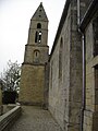 The Bell Tower
 -
 The Baptismal Font
 -
 Altar and Retable


Activities and events edit
The Romanes d'Anguerny is held every two years in spring.
See also edit
References edit
- ^ Populations légales 2013: Téléchargement du fichier d'ensemble, INSEE
- ^ Arrêté préfectoral 30 September 2015 (in French)
- ^ a b Google Maps
- ^ List of Mayors of France
- ^ National Commission for Decentralised cooperation (in French)
- ^ Le nom des habitants du 14 - Calvados, habitants.fr
- ^ Des villages de Cassini aux communes d'aujourd'hui: Commune data sheet Anguerny, EHESS (in French).
- ^ Populations légales 2012, INSEE
- ^ Ministry of Culture, Mérimée PA00111012 Church of Saint Martin (in French)

- ^ Ministry of Culture, Palissy PM14001088 Tabernacle and Seating (in French)
- ^ Ministry of Culture, Palissy PM14001087 Painting: Calvary (in French)
- ^ Ministry of Culture, Palissy PM14001086 Retable (in French)
- ^ Ministry of Culture, Palissy PM14000005 Main Altar: The Crucifixion (in French)
External links edit
- Anguerny official website (in French)
- Anguerny on Géoportail, National Geographic Institute (IGN) website (in French)
- Aguerny on the 1750 Cassini Map