The World Portal


The world is the totality of entities, the whole of reality, or everything that exists. The nature of the world has been conceptualized differently in different fields. Some conceptions see the world as unique while others talk of a "plurality of worlds". Some treat the world as one simple object while others analyze the world as a complex made up of parts.
In scientific cosmology, the world or universe is commonly defined as "[t]he totality of all space and time; all that is, has been, and will be". Theories of modality talk of possible worlds as complete and consistent ways how things could have been. Phenomenology, starting from the horizon of co-given objects present in the periphery of every experience, defines the world as the biggest horizon or the "horizon of all horizons". In philosophy of mind, the world is contrasted with the mind as that which is represented by the mind. Theology conceptualizes the world in relation to God, for example, as God's creation, as identical to God or as the two being interdependent. In religions, there is a tendency to downgrade the material or sensory world in favor of a spiritual world to be sought through religious practice. A comprehensive representation of the world and our place in it, as is found in religions, is known as a worldview. Cosmogony is the field that studies the origin or creation of the world while eschatology refers to the science or doctrine of the last things or of the end of the world.
In various contexts, the term "world" takes a more restricted meaning associated, for example, with the Earth and all life on it, with humanity as a whole or with an international or intercontinental scope. In this sense, world history refers to the history of humanity as a whole and world politics is the discipline of political science studying issues that transcend nations and continents. Other examples include terms such as "world religion", "world language", "world government", "world war", "world population", "world economy", or "world championship". (Full article...)
Selected articles -
-

The Cricket World Cup (officially known as ICC Men's Cricket World Cup) is the international championship of One Day International (ODI) cricket. The event is organised by the sport's governing body, the International Cricket Council (ICC), every four years, with preliminary qualification rounds leading up to a finals tournament. The tournament is one of the world's most viewed sporting events and considered as the "flagship event of the international cricket calendar" by the ICC. It is widely considered the pinnacle championship of the sport of cricket.
The first World Cup was organised in England in June 1975, with the first ODI cricket match having been played only four years earlier. However, a separate Women's Cricket World Cup had been held two years before the first men's tournament, and a tournament involving multiple international teams had been held as early as 1912, when a triangular tournament of Test matches was played between Australia, England and South Africa. The first three World Cups were held in England. From the 1987 tournament onwards, hosting has been shared between countries under an unofficial rotation system, with fourteen ICC members having hosted at least one match in the tournament. (Full article...) -
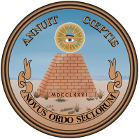
The reverse side of the Great Seal of the United States (1776). The Latin phrase novus ordo seclorum, appearing on the reverse side of the Great Seal since 1782 and on the back of the U.S. one-dollar bill since 1935, translates to "New Order of the Ages", and alludes to the beginning of an era where the United States of America is an independent nation-state; conspiracy theorists claim this is an allusion to the "New World Order".
The New World Order (NWO) is a term used in several conspiracy theories which hypothesize a secretly emerging totalitarian world government. The common theme in conspiracy theories about a New World Order is that a secretive power elite with a globalist agenda is conspiring to eventually achieve world domination and rule the world through an authoritarian one-world government—which will replace sovereign nation-states—and an all-encompassing propaganda whose ideology hails the establishment of the New World Order as the culmination of history's progress. Many influential historical and contemporary figures have therefore been alleged to be part of a cabal that operates through many front organizations to orchestrate significant political and financial events, ranging from causing systemic crises to pushing through controversial policies, at both national and international levels, as steps in an ongoing plot to achieve world domination.
Before the early 1990s, New World Order conspiracism was limited to two American countercultures, primarily the militantly anti-government right, and secondarily the part of fundamentalist Christianity concerned with the eschatological end-time emergence of the Antichrist. Academics who study conspiracy theories and religious extremism, such as Michael Barkun and Chip Berlet, observed that right-wing populist conspiracy theories about a New World Order not only had been embraced by many seekers of stigmatized knowledge but also had seeped into popular culture, thereby fueling a surge of interest and participation in survivalism and paramilitarism as many people actively prepare for apocalyptic and millenarian scenarios. These political scientists warn that mass hysteria over New World Order conspiracy theories could eventually have devastating effects on American political life, ranging from escalating lone-wolf terrorism to the rise to power of authoritarian ultranationalist demagogues. (Full article...) -
The term "new world order" refers to a new period of history evidencing dramatic change in world political thought and the balance of power in international relations. Despite varied interpretations of this term, it is commonly associated with the notion of world governance.
The phrase "new world order" or similar language was used in the period toward the end of the First World War in relation to Woodrow Wilson's vision for international peace; Wilson called for a League of Nations to prevent aggression and conflict. In some instances when Franklin D. Roosevelt used the phrase "new world order", or "new order in the world" it was to refer to Axis powers plans for world domination. Although Roosevelt and Harry S. Truman may have been hesitant to use the phrase, commentators have applied the term retroactively to the order put in place by the World War II victors including the United Nations and the Bretton Woods system as a "new world order." (Full article...) -

Unemployed people lined up outside a soup kitchen in Chicago.
The Great Depression (1929–1939) was a severe global economic downturn that affected many countries across the world. It became evident after a sharp decline in stock prices in the United States, leading to a period of economic depression. The economic contagion began around September 1929 and led to the Wall Street stock market crash of 24 October (Black Thursday). This crisis marked the start of a prolonged period of economic hardship characterized by high unemployment rates and widespread business failures.
Between 1929 and 1932, worldwide gross domestic product (GDP) fell by an estimated 15%. By comparison, worldwide GDP fell by less than 1% from 2008 to 2009 during the Great Recession. Some economies started to recover by the mid-1930s. However, in many countries,[specify] the negative effects of the Great Depression lasted until the beginning of World War II. Devastating effects were seen in both rich and poor countries with falling personal income, prices, tax revenues, and profits. International trade fell by more than 50%, unemployment in the U.S. rose to 23% and in some countries rose as high as 33%. Cities around the world were hit hard, especially those dependent on heavy industry. Construction was virtually halted in many countries. Farming communities and rural areas suffered as crop prices fell by about 60%. Faced with plummeting demand and few job alternatives, areas dependent on primary sector industries suffered the most. (Full article...) -
This article lists the world's busiest container ports (ports with container terminals that specialize in handling goods transported in intermodal shipping containers), by total number of twenty-foot equivalent units (TEUs) transported through the port. The table lists volume in thousands of TEU per year. The vast majority of containers moved by large, ocean-faring container ships are 20-foot (1 TEU) and 40-foot (2 TEU) ISO-standard shipping containers, with 40-foot units outnumbering 20-foot units to such an extent that the actual number of containers moved is between 55%–60% of the number of TEUs counted. (Full article...)
-
The BWF World Tour is a Grade 2 badminton tournament series, sanctioned by Badminton World Federation (BWF). It is a competition open to the top world ranked players in singles (men's and women's) and doubles (men's, women's and mixed). The competition was announced on 19 March 2017 and came into effect starting from 2018, replacing the BWF Super Series, which was held from 2007 to 2017.
The BWF World Tour are divided into six levels, namely World Tour Finals, Super 1000, Super 750, Super 500, and Super 300 in order (part of the HSBC World Tour). One other category of tournament, the BWF Tour Super 100 level, also offers ranking points. (Full article...) -
The United Nations uses three definitions for what constitutes a city, as not all cities in all jurisdictions are classified using the same criteria. Cities may be defined as the cities proper, the extent of their urban area, or their metropolitan regions. (Full article...)


.svg)

General images -
-
 Geologic map of North America, color-coded by age. From most recent to oldest, age is indicated by yellow, green, blue, and red. The reds and pinks indicate rock from the Archean.
 -
 A composite image of Earth, with its different types of surface discernible: Earth's surface dominating Ocean (blue), Africa with lush (green) to dry (brown) land and Earth's polar ice in the form of Antarctic sea ice (grey) covering the Antarctic or Southern Ocean and the Antarctic ice sheet (white) covering Antarctica. (from Earth)
 -
 Earth's western hemisphere showing topography relative to Earth's center instead of to mean sea level, as in common topographic maps (from Earth)
 -
 A reconstruction of human history based on fossil data. (from History of Earth)
 -
 An artist's impression of ice age Earth at glacial maximum. (from History of Earth)
 -
 Earth's history with time-spans of the eons to scale (from History of Earth)
 -

-
 Olmec colossal head, now at the Museo de Antropología de Xalapa
 -
 A schematic view of Earth's magnetosphere with solar wind flowing from left to right (from Earth)
 -
 Angkor Wat temple complex, Cambodia, early 12th century
 -

-

-
 The pale orange dot, an artist's impression of the early Earth which might have appeared orange through its hazy methane rich prebiotic second atmosphere. Earth's atmosphere at this stage was somewhat comparable to today's atmosphere of Titan. (from History of Earth)
 -
 A composite image of artificial light emissions at night on a map of Earth (from Earth)
 -
 Graph showing range of estimated partial pressure of atmospheric oxygen through geologic time (from History of Earth)
 -

-

-

-
Pale orange dot, an artist's impression of Early Earth, featuring its tinted orange methane-rich early atmosphere (from Earth)
-
 Artist's impression of a Hadean landscape with the relatively newly formed Moon still looming closely over Earth and both bodies sustaining strong volcanism. (from History of Earth)
 -

-
 View of Earth from the Moon by the Lunar Reconnaissance Orbiter (from Earth)
 -
 Image of the physical world, captured by the Hubble Space Telescope (from World)
 -
 An artist's rendering of a protoplanetary disk (from History of Earth)
 -
 A view of Earth with different layers of its atmosphere visible: the troposphere with its clouds casting shadows, a band of stratospheric blue sky at the horizon, and a line of green airglow of the lower thermosphere around an altitude of 100 km, at the edge of space (from Earth)
 -
 Fall of the Berlin Wall, 1989
 -
 A computer-generated image mapping the prevalence of artificial satellites and space debris around Earth in geosynchronous and low Earth orbit (from Earth)
 -
 Tiktaalik, a fish with limb-like fins and a predecessor of tetrapods. Reconstruction from fossils about 375 million years old. (from History of Earth)
 -
 Great Mosque of Kairouan, Tunisia, founded 670 CE
 -
 Vitruvian Man by Leonardo da Vinci epitomizes the advances in art and science seen during the Renaissance. (from History of Earth)
 -
 Florence, birthplace of the Italian Renaissance
 -
 Standing Buddha from Gandhara, 2nd century CE
 -
 Artist's conception of Hadean Eon Earth, when it was much hotter and inhospitable to all forms of life. (from History of Earth)
 -
 Ming dynasty section, Great Wall of China
 -
 Dinosaurs were the dominant terrestrial vertebrates throughout most of the Mesozoic (from History of Earth)
 -
 Earth's axial tilt causing different angles of seasonal illumination at different orbital positions around the Sun (from Earth)
 -
 Japanese depiction of a Portuguese carrack. European maritime innovations led to proto-globalization.
 -
 Artist's rendition of an oxinated fully-frozen Snowball Earth with no remaining liquid surface water. (from History of Earth)
 -
 Obelisk of Axum, Ethiopia
 -
 Last Moon landing: Apollo 17 (1972)
 -
 A Benin Bronze head from Nigeria
 -

-
 Chennakesava Temple, Belur, India
 -

-
 Artist's conception of Devonian flora (from History of Earth)
 -
 A pillar at Göbekli Tepe
 -

-
 An artist's impression of the Archean, the eon after Earth's formation, featuring round stromatolites, which are early oxygen-producing forms of life from billions of years ago. After the Late Heavy Bombardment, Earth's crust had cooled, its water-rich barren surface is marked by continents and volcanoes, with the Moon still orbiting Earth half as far as it is today, appearing 2.8 times larger and producing strong tides. (from Earth)
 -
 Ajloun Castle, Jordan
 -
 A map of heat flow from Earth's interior to the surface of Earth's crust, mostly along the oceanic ridges (from Earth)
 -
 Notre-Dame de Paris, France
 -

-
 Great Pyramids of Giza, Egypt
 -
 Tracy Caldwell Dyson, a NASA astronaut, observing Earth from the Cupola module at the International Space Station on 11 September 2010 (from Earth)
 -
 The Pantheon, originally a Roman temple, now a Catholic church
 -

-
Artist's impression of Earth during the later Archean, the largely cooled planetary crust and water-rich barren surface, marked by volcanoes and continents, features already round microbialites. The Moon, still orbiting Earth much closer than today and still dominating Earth's sky, produced strong tides. (from History of Earth)
-

-
 A banded iron formation from the 3.15 Ga Moodies Group, Barberton Greenstone Belt, South Africa. Red layers represent the times when oxygen was available; gray layers were formed in anoxic circumstances. (from History of Earth)
 -
 First airplane, the Wright Flyer, flew on 17 December 1903.
 -
 Cross-section through a liposome (from History of Earth)
 -
 Yggdrasil, an attempt to reconstruct the Norse world tree which connects the heavens, the world, and the underworld. (from World)
 -
 Machu Picchu, Inca Empire, Peru
 -

-

-
 Lithified stromatolites on the shores of Lake Thetis, Western Australia. Archean stromatolites are the first direct fossil traces of life on Earth. (from History of Earth)
 -
 Taj Mahal, Mughal Empire, India
 -
 Earth's night-side upper atmosphere appearing from the bottom as bands of afterglow illuminating the troposphere in orange with silhouettes of clouds, and the stratosphere in white and blue. Next the mesosphere (pink area) extends to the orange and faintly green line of the lowest airglow, at about one hundred kilometers at the edge of space and the lower edge of the thermosphere (invisible). Continuing with green and red bands of aurorae stretching over several hundred kilometers. (from Earth)
 -
 Change in average surface air temperature and drivers for that change. Human activity has caused increased temperatures, with natural forces adding some variability. (from Earth)
 -
 A view of Earth with its global ocean and cloud cover, which dominate Earth's surface and hydrosphere; at Earth's polar regions, its hydrosphere forms larger areas of ice cover. (from Earth)
 -
 The replicator in virtually all known life is deoxyribonucleic acid. DNA is far more complex than the original replicator and its replication systems are highly elaborate. (from History of Earth)
 -

-
 Chloroplasts in the cells of a moss (from History of Earth)
 -

-
 Persepolis, Achaemenid Empire, 6th century BCE
 -
 "Lucy", the first Australopithecus afarensis skeleton found. Lucy was only 1.06 m (3 ft 6 in) tall.
 -
 Shanghai. China urbanized rapidly in the 21st century.
 -
 A 2012 artistic impression of the early Solar System's protoplanetary disk from which Earth and other Solar System bodies were formed (from Earth)
 -
 Trilobites first appeared during the Cambrian period and were among the most widespread and diverse groups of Paleozoic organisms. (from History of Earth)
 -
 Artist's impression of the enormous collision that probably formed the Moon (from History of Earth)
 -

-

-
 A reconstruction of Pannotia (550 Ma). (from History of Earth)
 -
 A 580 million year old fossil of Spriggina floundensi, an animal from the Ediacaran period. Such life forms could have been ancestors to the many new forms that originated in the Cambrian Explosion. (from History of Earth)
 -
 An animation of the changing density of productive vegetation on land (low in brown; heavy in dark green) and phytoplankton at the ocean surface (low in purple; high in yellow) (from Earth)
 -
 Earth's land use for human agriculture in 2019 (from Earth)
 -
 Battle during 1281 Mongol invasion of Japan
 -
 Empires of the world in 1898
 -
 Map of peopling of the world (Southern Dispersal paradigm), in thousands of years ago.
 -
 Satellite time lapse imagery of Earth's rotation showing axis tilt (from Earth)
 -

-
 Pangaea was a supercontinent that existed from about 300 to 180 Ma. The outlines of the modern continents and other landmasses are indicated on this map. (from History of Earth)


.jpg)


.jpg)

.jpeg)


.svg)

.jpg)


Megacities of the world -
.jpg)
Beijing, alternatively romanized as Peking, is the capital of China. With more than 22 million residents, Beijing is the world's most populous national capital city as well as China's second largest city after Shanghai. It is located in Northern China, and is governed as a municipality under the direct administration of the State Council with 16 urban, suburban, and rural districts. Beijing is mostly surrounded by Hebei Province with the exception of neighboring Tianjin to the southeast; together, the three divisions form the Jingjinji megalopolis and the national capital region of China.
Beijing is a global city and one of the world's leading centres for culture, diplomacy, politics, finance, business and economics, education, research, language, tourism, media, sport, science and technology and transportation and art. It is home to the headquarters of most of China's largest state-owned companies and houses the largest number of Fortune Global 500 companies in the world, as well as the world's four biggest financial institutions by total assets. It is also a major hub for the national highway, expressway, railway, and high-speed rail networks. For a decade before the COVID-19 pandemic, the Beijing Capital International Airport was Asia's busiest airport (2009–2019) and the second busiest airport in the world (2010–2019). In 2020, the Beijing subway was the fourth busiest and second longest in the world. The Beijing Daxing International Airport, Beijing's second international airport, is the largest single-structure airport terminal in the world. (Full article...)Did you know -

- ... that a Stone Age Siberian village is the oldest known fortification in the world?
- ... that a Florida TV station operated from an abandoned amusement park?
- ... that The New York Times described China Chalet "as if New York's art world had been transported to a Holiday Inn in the Midwest"?
- ... that there are only about 30 Ancient Egyptian obelisks left standing worldwide—and Italy has more than Egypt?
- ... that Oakwood Cemetery contains the graves of Confederate soldiers and officers, English, Canadian, and French World War II pilots, and Hank Williams?
- ... that despite losing his left arm in World War II, Austrian tennis player Hans Redl reached the fourth round at Wimbledon in 1947?
- ... that Willi Brokmeier, who participated in the world premiere of Die Soldaten at the Cologne Opera, appeared as Beethoven's Jaquino on a tour to Japan?
- ... that the chicken turtle is one of the shortest-lived turtle species in the world?
Countries of the world -

Madagascar, officially the Republic of Madagascar, is an island country comprising the island of Madagascar and numerous smaller peripheral islands. Lying off the southeastern coast of Africa, it is the world's fourth largest island, the second-largest island country and the 46th largest country in the world. Its capital and largest city is Antananarivo.
Following the prehistoric breakup of the supercontinent Gondwana, Madagascar split from Africa during the Early Jurassic, around 180 million years ago, and split from the Indian subcontinent around 90 million years ago, allowing native plants and animals to evolve in relative isolation; consequently, it is a biodiversity hotspot and one of the world's 17 megadiverse countries, with over 90% of wildlife being endemic. The island has a subtropical to tropical maritime climate. Madagascar was first settled during or before the mid-first millennium AD by Austronesian peoples, presumably arriving on outrigger canoes from present-day Indonesia. These were joined around the ninth century AD by Bantu migrants crossing the Mozambique Channel from East Africa. Other groups continued to settle on Madagascar over time, each one making lasting contributions to Malagasy cultural life. Consequently, there are 18 or more classified peoples of Madagascar, the most numerous being the Merina of the central highlands. (Full article...)
The Seven Wonders of Wales (Welsh: Saith Rhyfeddod Cymru) is a traditional list of notable landmarks in north Wales, commemorated in an anonymously written rhyme:
The rhyme is usually supposed to have been written sometime in the late 18th or early 19th century by an English visitor to North Wales. The specific number of wonders may have varied over the years: the antiquary Daines Barrington, in a letter written in 1770, refers to Llangollen Bridge as one of the "five wonders of Wales, though like the seven wonders of Dauphiny, they turn out to be no wonders at all out of the Principality". (Full article...)Related portals
Protected areas of the world -
-

Overview of IUCN Protected area - WAP (W, Arli, Pendjari) area - Niger, Burkina Faso, and Benin
The following is a list of protected areas of Burkina Faso. (Full article...) -

There are numerous parks throughout the sovereign island country of Singapore. This is a list of parks in Singapore that are currently existing and have articles on Wikipedia. Most parks in Singapore are managed by the National Parks Board, although smaller neighbourhood parks are managed by the Housing Development Board. Most of these parks are connected via the Park Connector Network (PCN). (Full article...) -
Protected areas of Tasmania consist of protected areas located within Tasmania and its immediate onshore waters, including Macquarie Island. It includes areas of crown land (withheld land) managed by Tasmanian Government agencies as well as private reserves. As of 2016, 52% of Tasmania's land area has some form of reservation classification, the majority is managed by the Tasmania Parks & Wildlife Service (about 42% of total Tasmanian land area). Marine protected areas cover about 7.9% of state waters.
Within each classification of reserve there may be a variation of IUCN categories Australia is a signatory to the Convention of Biological Diversity and as such has obligations to report the status of its National Reserve System.IUCN provides on its website a prescription for activities consistent with the categorisation system. Changes made to the Nature Conservation Act 2002 in 2014 permit timber harvesting. These changes made in addition to the already established right to access minerals means that many of the IUCN categorisations assigned to individual reserves in Tasmania are no longer fit for purpose. In addition many reserves have had their reserve status downgraded from a class excluding timber harvesting and mineral extraction to ones where these activities are now permitted. This mis-application of the IUCN protected area categories needs to be remedied or the reserves protected land class under the Nature Conservation Act 2002 should be adjusted to reflect its currently assigned IUCN category. (Full article...) -

A view of Kaptai National Park
This is a list of protected areas of Bangladesh. Bangladesh is a country in South Asia. It is the eighth-most populous country in the world, with a population exceeding 163 million people in an area of either 148,460 square kilometres (57,320 sq mi) or 147,570 square kilometres (56,980 sq mi), making it one of the most densely populated countries in the world. (Full article...) -
-

Cranes at Sevan National Park
This is a list of protected areas in Armenia that are categorized as follows: 4 national parks, 3 state reserves, 27 state sanctuaries and 5 botanical gardens. (Full article...) -
Protected areas of Ukraine (Ukrainian: охоронні території) are special areas of Ukraine established with the goal of protecting the natural and cultural heritage of the country from excessive changes as a result of human activity. The protection of the areas is the responsibility of the government of Ukraine, specifically the Cabinet of Ministers of Ukraine.
Ukraine has several categories of protected areas of Ukraine and the protected areas include: (Full article...) -
Protected areas of the European Union are areas which need and/or receive special protection because of their environmental, cultural or historical value to the member states of the European Union.
(Full article...) -
The Australian Capital Territory as of 2014 contains 46 separate protected areas with a total land area of 1,302 km2 (503 sq mi) or 55.5% of the territory's area, and which managed by Territory and Municipal Services of the ACT government: (Full article...)
-
Protected areas in the U.S. State of Ohio include national forest lands, Army Corps of Engineers areas, state parks, state forests, state nature preserves, state wildlife management areas, and other areas. (Full article...)
-
Greece is characterized by an extremely fragmented, rugged landscape hosting a great diversity of ecosystems and an outstanding biodiversity. Almost 5% of its extensive coastline consists of ecologically sensitive wetlands. Two thirds of the total population live no further than 2 km from the coast and most of the important urban centers are coastal, while almost all of the tourist infrastructure is divided among islands and the coastal mainland. (Full article...)
-
Protected areas of Canada consist of approximately 12.1 percent of the nation's landmass and freshwater are considered conservation areas, including 11.4 percent designated as protected areas. Approximately 13.8 percent of Canada's territorial waters are conserved, including 8.9 percent designated as protected areas. Terrestrial areas conserved have increased by 65 percent in the 21st century, while marine areas conserved have increased by more than 3,800 percent.
Conservation and protected areas have different mandates depending on the organization which manages them, with some areas having a greater focus on ecological integrity, historical preservation, public usage, scientific research, or a combination of usages. Some areas such as the Polar Bear Pass, are co-managed and overseen by government and local indigenous agencies. (Full article...) -

Ludaš Lake is a shallow lake in the province of Vojvodina in northern Serbia, near the city of Subotica. It is a special natural preserve and, since 1977, designated as a swamp area of international significance by the Ramsar Convention.
Protected areas cover around 5% of the territory of Serbia. The Law on the Protection of the Nature defines these categories of protected areas:- Strict nature reserve — Area of unmodified natural features with representative ecosystems set aside for the preservation of its biodiversity and for scientific research and monitoring.
- Special nature reserve — Area of unmodified or slightly modified natural features of great importance due to uniqueness and rarity which includes the habitats of endangered species set aside for the preservation of its unique features, education, limited tourism and for scientific research and monitoring.
- National park — Area with large number of diverse ecosystems of national value, with outstanding natural features and/or cultural heritage set aside for the preservation of its natural resources and for educational, scientific and tourist use.
- Natural monument — Small unmodified or slightly modified natural feature, object or phenomenon, easily detectable and unique, with unique natural attributes.
- Protected habitat — Area which includes habitats of one or more wildlife species.
- Landscape of outstanding features — Area of remarkable appearance with important natural and cultural value.
- Nature park — Area of well-preserved natural values with preserved natural ecosystems and picturesque landscape set aside for the preservation of biodiversity and for educational, tourist, recreational and scientific use.
-
Protected areas of West Bengal cover 4% of the state area. Forests make up 14% of the geographical area of West Bengal, which is lower than the national average of 33%. West Bengal has a wide variety of fauna, including Bengal tigers, Indian leopards, sloth and Himalayan black bears, chital and sambar (deer), Indian boars, pygmy hogs, Indian elephants, Indian peafowl, great Indian hornbills, Eurasian spoonbills, brahminy ducks, king and Indian cobras, white-lipped pit viper, Indian and reticulated pythons, mugger crocodiles, saltwater crocodiles, gharials, and many more. A huge montane forest, Dooars, is situated in the Northern West Bengal districts of Alipur Duar, Darjeeling, and Kalimpong. Part of the world's largest mangrove forest, Sundarbans, is located in southern West Bengal.
There are 6 national parks and 15 wildlife sanctuaries in West Bengal. (Full article...) -
The Protected areas of Kyrgyzstan are regulated by the law on specially protected natural areas of 2 May 2011, last modified on 2 June 2018. In total, they cover 14,761.216 km2 (5,699.337 sq mi) and account for 7.38% of the country's total area (as of 2017). The first protected area in Kyrgyzstan (Issyk-Kul) was established in 1948. According to the Government Decree on Priorities of Conservation of Biological Diversity and the relevant Action Plan for 2014-2024 the target area for the protected areas in Kyrgyzstan is 10 percent of the country’s area by 2024.
The protected areas are subdivided into seven categories: (Full article...)


Selected world maps
-
 United Nations Human Development Index map by country (2016)
 -
 The world map by Gerardus Mercator (1569), the first map in the well-known Mercator projection
 -
 Only a few of the largest large igneous provinces appear (coloured dark purple) on this geological map, which depicts crustal geologic provinces as seen in seismic refraction data
 -
 The Goode homolosine projection is a pseudocylindrical, equal-area, composite map projection used for world maps.
 -
 1516 map of the world by Martin Waldseemüller
 -
 Time zones of the world
 -
 A plate tectonics map with volcano locations indicated with red circles
 -
 Index map from the International Map of the World (1:1,000,000 scale)
 -
 Mollweide projection of the world


World records
- List of Olympic records in athletics
- List of world records in athletics
- List of junior world records in athletics
- List of world records in masters athletics
- List of world youth bests in athletics
- List of IPC world records in athletics
- List of world records in canoeing
- List of world records in chess
- List of cycling records
- List of world records in track cycling
- List of world records in finswimming
- List of world records in juggling
- List of world records in rowing
- List of world records in speed skating
- List of world records in swimming
- List of IPC world records in swimming
- List of world records in Olympic weightlifting
Topics

Continents of Earth | ||||||||
|---|---|---|---|---|---|---|---|---|
| ||||||||
| ||||||||
| ||||||||


| Cenozoic Era (present–66.0 Ma) |
| ||||||||||||
|---|---|---|---|---|---|---|---|---|---|---|---|---|---|
| Mesozoic Era (66.0–252 Ma) |
| ||||||||||||
| Paleozoic Era (252–539 Ma) |
| ||||||||||||
| Proterozoic Eon (539 Ma–2.5 Ga) |
| ||||||||||||
| Archean Eon (2.5–4 Ga) | |||||||||||||
| Hadean Eon (4–4.6 Ga) | |||||||||||||
ka = kiloannum (thousands years ago); Ma = megaannum (millions years ago); Ga = gigaannum (billions years ago). See also: Geologic time scale • | |||||||||||||
| Locations | ||
|---|---|---|
| Related | ||

| |||||||||||||||||||
| |||||||||||||||||||
| |||||||||||||||||||

Economic classification of countries | |||||
|---|---|---|---|---|---|
| Three-World Model | |||||
| Gross domestic product (GDP) |
| ||||
| Gross national income (GNI) | |||||
| Wages | |||||
| Wealth | |||||
| Other national accounts | |||||
| Human development | |||||
| Digital divide | |||||
| Net international investment position (NIIP) | |||||
| Technological |
| ||||
|---|---|---|---|---|---|
| Sociological | |||||
| Ecological |
| ||||
| Biological |
| ||||
| Astronomical | |||||
| Eschatological |
| ||||
| Others |
| ||||
| Fictional | |||||
| Organizations | |||||
Categories

Wikimedia
The following Wikimedia Foundation sister projects provide more on this subject:
-
 Commons
Free media repository -
 Wikibooks
Free textbooks and manuals -
 Wikidata
Free knowledge base -
 Wikinews
Free-content news -
 Wikiquote
Collection of quotations -
 Wikisource
Free-content library -
 Wikispecies
Directory of species -
 Wikiversity
Free learning tools -
 Wikivoyage
Free travel guide -
 Wiktionary
Dictionary and thesaurus


