ကြိုဆိုပါတယ်။ / Welcome to the Myanmar Portal 

Myanmar, officially the Republic of the Union of Myanmar and also known as Burma (the official name until 1989), is a country in Southeast Asia. It is the largest country by area in Mainland Southeast Asia and has a population of about 55 million. It is bordered by Bangladesh and India to its northwest, China to its northeast, Laos and Thailand to its east and southeast, and the Andaman Sea and the Bay of Bengal to its south and southwest. The country's capital city is Naypyidaw, and its largest city is Yangon (formerly Rangoon).
Myanmar is a member of the East Asia Summit, Non-Aligned Movement, ASEAN, and BIMSTEC, but it is not a member of the Commonwealth of Nations despite once being part of the British Empire. Myanmar is a Dialogue Partner of the Shanghai Cooperation Organization. The country is very rich in natural resources, such as jade, gems, oil, natural gas, teak and other minerals, as well as also endowed with renewable energy, having the highest solar power potential compared to other countries of the Great Mekong Subregion. However, Myanmar has long suffered from instability, factional violence, corruption, poor infrastructure, as well as a long history of colonial exploitation with little regard to human development. In 2013, its GDP (nominal) stood at US$56.7 billion and its GDP (PPP) at US$221.5 billion. The income gap in Myanmar is among the widest in the world, as a large proportion of the economy is controlled by cronies of the military junta. Myanmar is one of the least developed countries; as of 2020, according to the Human Development Index, it ranks 147 out of 189 countries in terms of human development, the lowest in Southeast Asia. Since 2021, more than 600,000 people were displaced across Myanmar due to the surge in violence post-coup, with more than 3 million people in dire need of humanitarian assistance. (Full article...)
Selected articles -
-
![Image 1 The royal chronicles of Myanmar (Burmese: မြန်မာ ရာဇဝင် ကျမ်းများ [mjəmà jàzəwɪ̀ɰ̃ tɕáɰ̃ mjá]; also known as Burmese chronicles) are detailed and continuous chronicles of the monarchy of Myanmar (Burma). The chronicles were written on different media such as parabaik paper, palm leaf, and stone; they were composed in different literary styles such as prose, verse, and chronograms. Palm-leaf manuscripts written in prose are those that are commonly referred to as the chronicles. Other royal records include administrative treatises and precedents, legal treatises and precedents, and censuses. The chronicle tradition was maintained in the country's four historical polities: Upper Burma, Lower Burma, Arakan and the Shan states. The majority of the chronicles did not survive the country's numerous wars as well as the test of time. The most complete extant chronicles are those of Upper Burma-based dynasties, with the earliest extant chronicle dating from the 1280s and the first standard national chronicle from the 1720s. (Full article...)](//upload.wikimedia.org/wikipedia/en/d/d2/Blank.png) The royal chronicles of Myanmar (Burmese: မြန်မာ ရာဇဝင် ကျမ်းများ [mjəmà jàzəwɪ̀ɰ̃ tɕáɰ̃ mjá]; also known as Burmese chronicles) are detailed and continuous chronicles of the monarchy of Myanmar (Burma). The chronicles were written on different media such as parabaik paper, palm leaf, and stone; they were composed in different literary styles such as prose, verse, and chronograms. Palm-leaf manuscripts written in prose are those that are commonly referred to as the chronicles. Other royal records include administrative treatises and precedents, legal treatises and precedents, and censuses.
The royal chronicles of Myanmar (Burmese: မြန်မာ ရာဇဝင် ကျမ်းများ [mjəmà jàzəwɪ̀ɰ̃ tɕáɰ̃ mjá]; also known as Burmese chronicles) are detailed and continuous chronicles of the monarchy of Myanmar (Burma). The chronicles were written on different media such as parabaik paper, palm leaf, and stone; they were composed in different literary styles such as prose, verse, and chronograms. Palm-leaf manuscripts written in prose are those that are commonly referred to as the chronicles. Other royal records include administrative treatises and precedents, legal treatises and precedents, and censuses.
The chronicle tradition was maintained in the country's four historical polities: Upper Burma, Lower Burma, Arakan and the Shan states. The majority of the chronicles did not survive the country's numerous wars as well as the test of time. The most complete extant chronicles are those of Upper Burma-based dynasties, with the earliest extant chronicle dating from the 1280s and the first standard national chronicle from the 1720s. (Full article...) -
Zigrasimecia is an extinct genus of ants which existed in the Cretaceous period approximately 98 million years ago. The first specimens were collected from Burmese amber in Kachin State, 100 kilometres (62 mi) west of Myitkyina town in Myanmar. In 2013, palaeoentomologists Phillip Barden and David Grimaldi published a paper describing and naming Zigrasimecia tonsora. They described a dealate female with unusual features, notably the highly specialized mandibles. Other features include large ocelli, short scapes, 12 antennomeres, small eyes, and a clypeal margin that has a row of peg-like denticles. The genus Zigrasimecia was originally incertae sedis (uncertain placement) within Formicidae until a second species, Zigrasimecia ferox, was described in 2014, leading to its placement in the subfamily Sphecomyrminae. Later, it was considered to belong to the distinct subfamily Zigrasimeciinae.
Due to the highly specialized mandibles, scientists believe that the ants exhibited habits no longer seen in extant ants. The highly movable head suggests that mobility was an important factor for them (probably for feeding behavior), and the rugose projections may have played a major role in nest excavation because the mandibles would have prevented such activity. Zigrasimecia most likely interacted with the extinct ant genus Gerontoformica through conflict and probably shared some of their ecological niches. The mandibles of these ants were probably used for mechanical interactions with food, and they may also have served as traps for potential arthropod prey such as mites and small flies. Zigrasimecia was possibly a generalist predator. (Full article...) -
The prehistory of Burma (Myanmar) spanned hundreds of millennia to about 200 BCE. Archaeological evidence shows that the Homo erectus had lived in the region now known as Burma as early as 750,000 years ago, and the Homo sapiens about 11,000 BCE, in a Stone Age culture called the Anyathian. Named after the central dry zone sites where most of the early settlement finds are located, the Anyathian period was when plants and animals were first domesticated and polished stone tools appeared in Burma. Though these sites are situated in fertile areas, evidence shows these early people were not yet familiar with agricultural methods.
The Bronze Age arrived c. 1500 BCE when people in the region were turning copper into bronze, growing rice, and domesticating chickens and pigs. The Iron Age arrived around 500 BCE when iron-working settlements emerged in an area south of present-day Mandalay. Evidence also shows rice growing settlements of large villages and small cities that traded with their surroundings and as far as China between 500 BCE and 200 CE. Bronze-decorated coffins and burial sites filled with the earthenware remains of feasting and drinking provide a glimpse of the lifestyle of their affluent society. (Full article...) -
Indawgyi Lake Wildlife Sanctuary is a biosphere reserve in Myanmar, covering 814.99 km2 (314.67 sq mi). It ranges in elevation from 105–1,400 m (344–4,593 ft) encompassing the surroundings of Indawgyi Lake in Mohnyin Township, Kachin State. It was gazetted in 2004, is recognized as an Important Bird Area and as one of the ASEAN Heritage Parks.
An area of 478.84 km2 (184.88 sq mi) comprising the lake and the surrounding lowland is a Ramsar site since February 2016.
During a survey in the winter of 2004, both resident and migratory birds were sighted on the lake and along Indawgyi River, including white-rumped vulture (Gyps bengalensis), slender-billed vulture (G. tenuirostris), Himalayan vulture (G. himalayensis), lesser whistling duck (Dendrocygna javanica), tufted duck (Aythya fuligula), ferruginous pochard (A. nyroca), gadwall (Mareca strepera), ruddy shelduck (Tadorna ferruginea), Eurasian teal (Anas crecca), northern pintail (A. acuta), greylag goose (Anser anser), Eurasian coot (Fulica atra), little grebe (Tachybaptus ruficollis), great crested grebe (Podiceps cristatus), little cormorant (Microcarbo niger), purple heron (Ardea purpurea), brown-headed gull (Chroicocephalus brunnicephalus), black-headed gull (C. ridibundus), wood sandpiper (Tringa glareola), Temminck's stint (Calidris temminckii), black-winged stilt (Himantopus himantopus), grey-headed lapwing (Vanellus cinereus) and glossy ibis (Plegadis falcinellus). (Full article...) -
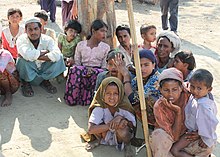
The Rohingya people (/roʊˈhɪndʒə, -ɪŋjə/; Rohingya: 𐴌𐴗𐴥𐴝𐴙𐴚𐴒𐴙𐴝, IPA: [rʊˈɜi̯ɲ.ɟə]) are a stateless Indo-Aryan ethnic group who predominantly follow Islam and reside in Rakhine State, Myanmar. Before the Rohingya genocide in 2017, when over 740,000 fled to Bangladesh, an estimated 1.4 million Rohingya lived in Myanmar. Described by journalists and news outlets as one of the most persecuted minorities in the world, the Rohingya are denied citizenship under the 1982 Myanmar nationality law. There are also restrictions on their freedom of movement, access to state education and civil service jobs. The legal conditions faced by the Rohingya in Myanmar have been compared to apartheid by some academics, analysts and political figures, including Nobel laureate Bishop Desmond Tutu, a South African anti-apartheid activist. The most recent mass displacement of Rohingya in 2017 led the International Criminal Court to investigate crimes against humanity, and the International Court of Justice to investigate genocide.
The Rohingya maintain they are indigenous to western Myanmar with a heritage of over a millennium and influence from the Arabs, Mughals, and Portuguese. The community claims it is descended from people in precolonial Arakan and colonial Arakan; historically, the region was an independent kingdom between Southeast Asia and the Indian subcontinent. The Myanmar government considers the Rohingya as British colonial and postcolonial migrants from Chittagong in Bangladesh. It argues that a distinct precolonial Muslim population is recognized as Kaman, and that the Rohingya conflate their history with the history of Arakan Muslims in general to advance a separatist agenda. In addition, Myanmar's government does not recognise the term "Rohingya" and prefers to refer to the community as "Bengali". Rohingya campaign groups and human rights organizations demand the right to "self-determination within Myanmar". (Full article...) -

The State Peace and Development Council (Burmese: နိုင်ငံတော် အေးချမ်းသာယာရေး နှင့် ဖွံ့ဖြိုးရေး ကောင်စီ [nàɪɰ̃ŋàɰ̃dɔ̀ ʔédʑáɰ̃θàjajé n̥ḭɰ̃ pʰʊ̰ɰ̃bjó jé kaʊ̀ɰ̃sì]; abbreviated SPDC or နအဖ, [na̰ʔa̰pʰa̰]) was the official name of the military government of Burma (Myanmar) which, in 1997, succeeded the State Law and Order Restoration Council (Burmese: နိုင်ငံတော် ငြိမ်ဝပ်ပိပြားမှု တည်ဆောက်ရေးအဖွဲ့; abbreviated SLORC or နဝတ) that had seized power under the rule of Saw Maung in 1988. On 30 March 2011, Senior General and Council Chairman Than Shwe signed a decree that officially dissolved the council.
SLORC succeeded the Pyithu Hluttaw as a legislature and the Council of State as a ruling council, after dissolving the state organs of the Socialist Republic of the Union of Burma. In 1997, SLORC was abolished and reconstituted as the State Peace and Development Council (SPDC). The powerful regional military commanders, who were members of SLORC, were promoted to new positions and transferred to the capital of Rangoon (now Yangon). The new regional military commanders were not included in the membership of the SPDC. (Full article...) -
Ne Win (Burmese: နေဝင်း; IPA: [nè wɪ́ɰ̃]; 24 May 1911 – 5 December 2002), born Shu Maung (Burmese: ရှူမောင်; IPA: [/ʃù màʊ̃̀/]), was a Burmese army general, politician and military commander who served as Prime Minister of Burma from 1958 to 1960 and 1962 to 1974, and also President of Burma from 1962 to 1981. Ne Win was Burma's military dictator during the Socialist Burma period of 1962 to 1988.
Ne Win founded the Burma Socialist Programme Party (BSPP) and overthrew the democratic Union Parliament of U Nu in the 1962 Burmese coup d'état, establishing Burma as a one-party socialist state under the Burmese Way to Socialism ideology. Ne Win was Burma's de facto leader as chairman of the BSPP, serving in various official titles as part of his military government, and was known by his supporters as U Ne Win. His rule was characterized by a non-aligned foreign policy, isolationism, one-party rule, economic stagnation, and superstition. Ne Win resigned in July 1988 in response to the 8888 Uprising that overthrew the Burma Socialist Programme Party (BSPP), and was replaced by the military junta of the State Law and Order Restoration Council (SLORC). He held minor influence in the 1990s but was eventually placed under house arrest, under which he died in 2002. (Full article...) -
The sun bear (Helarctos malayanus) is a species in the family Ursidae (the only species in the genus Helarctos) occurring in the tropical forests of Southeast Asia. It is the smallest bear species, standing nearly 70 cm (28 in) at the shoulder and weighing 25–65 kg (55–143 lb). It is stockily built, with large paws, strongly curved claws, small, rounded ears and a short snout. The fur is generally short and jet black, but can vary from grey to red. The sun bear gets its name from its characteristic orange to cream-coloured chest patch. Its unique morphology—inward-turned front feet, flattened chest, powerful forelimbs with large claws—suggests adaptations for climbing.
The most arboreal (tree-living) of all bears, the sun bear is an excellent climber and sunbathes or sleeps in trees 2 to 7 m (7 to 23 ft) above the ground. It is mainly active during the day, though nocturnality might be more common in areas frequented by humans. Sun bears tend to remain solitary, but sometimes occur in twos (such as a mother and her cub). They do not seem to hibernate, possibly because food resources are available the whole year throughout the range. Being omnivores, sun bears' diet includes ants, bees, beetles, honey, termites, and plant material such as seeds and several kinds of fruits; vertebrates such as birds and deer are also eaten occasionally. They breed throughout the year; individuals become sexually mature at two to four years of age. Litters comprise one or two cubs that remain with their mother for around three years. (Full article...) -
The Tenasserim Hills or Tenasserim Range (Burmese: တနင်္သာရီ တောင်တန်း, [tənɪ̀ɰ̃θàjì tàʊɰ̃dáɰ̃]; Thai: ทิวเขาตะนาวศรี, RTGS: Thio Khao Tanao Si, pronounced [tʰīw kʰǎw tā.nāːw sǐː]; Malay: Banjaran Tanah Seri/Banjaran Tenang Sari) is the geographical name of a roughly 1,700 km long mountain chain, part of the Indo-Malayan mountain system in Southeast Asia.
Despite their relatively scant altitude these mountains form an effective barrier between Thailand and Myanmar in their northern and central region. There are only two main transnational roads and cross-border points between Kanchanaburi and Tak, at the Three Pagodas Pass and at Mae Sot. The latter is located beyond the northern end of the range, where the Tenasserim Hills meet the Dawna Range. Minor cross-border points are Sing Khon, near Prachuap Khiri Khan, as well as Bong Ti and Phu Nam Ron west of Kanchanaburi. The latter is expected to gain in importance if the planned Dawei Port Project goes ahead, along with a highway and a railway line between Bangkok and that harbor. (Full article...) -

Magway Region (Burmese: မကွေးတိုင်းဒေသကြီး, pronounced [məɡwé táiɰ̃ dèθa̰ dʑí]; formerly Magway Division) is an administrative division in central Myanmar. It is the second largest of Myanmar's seven divisions, with an area of 44,820 km2 (17,306 square miles). Pa Del Dam (ပဒဲဆည်) is one of the dams in Aunglan Township, Magway Division. The capital and second largest city of the Magway Division is Magway. The largest city is Pakokku. The major cities of Magway Division are Magway, Pakokku, Aunglan, Yenangyaung, Taungdwingyi, Chauk, Minbu, Thayet and Gangaw. (Full article...)
![Image 1 The royal chronicles of Myanmar (Burmese: မြန်မာ ရာဇဝင် ကျမ်းများ [mjəmà jàzəwɪ̀ɰ̃ tɕáɰ̃ mjá]; also known as Burmese chronicles) are detailed and continuous chronicles of the monarchy of Myanmar (Burma). The chronicles were written on different media such as parabaik paper, palm leaf, and stone; they were composed in different literary styles such as prose, verse, and chronograms. Palm-leaf manuscripts written in prose are those that are commonly referred to as the chronicles. Other royal records include administrative treatises and precedents, legal treatises and precedents, and censuses. The chronicle tradition was maintained in the country's four historical polities: Upper Burma, Lower Burma, Arakan and the Shan states. The majority of the chronicles did not survive the country's numerous wars as well as the test of time. The most complete extant chronicles are those of Upper Burma-based dynasties, with the earliest extant chronicle dating from the 1280s and the first standard national chronicle from the 1720s. (Full article...)](/wiki/File:Blank.png)


_(cropped).jpg)
.svg)
.jpg)


Did you know (auto-generated) -

- ... that Maw Htun Aung, a Shan Nationalities League for Democracy candidate in the 2020 Myanmar general election, is Kachin, not Shan?
- ... that the talabaw soup, which consists primarily of bamboo shoots, is the essential dish of Myanmar's Karen people, who use it to supplement rice?
- ... that one academic described the introduction of femboys to Myanmar as a tactic to achieve an "ideological revolution"?
- ... that while defending Zaw Myint Maung following his arrest by the Myanmar junta, lawyer Ywet Nu Aung was herself arrested and charged?
- ... that the Myanmar Coast Guard was initially proposed as a civilian law enforcement agency before being established as a branch of the military three years later?
- ... that as part of the coronation of Mindon Min, the square yuzana around the capital was designated a sanctuary?
- ... that Aung Myo Min, Union Minister of Human Rights for the National Unity Government of Myanmar, is the country's first openly LGBT minister?
- ... that former Burmese actress Honey Nway Oo turned rebel and took up arms against the military junta following the 2021 Myanmar coup d'état?
Related portals and projects
General images -
-
 British soldiers on patrol in the ruins of the Burmese town of Bahe during the advance on Mandalay, January 1945. (from History of Myanmar)
 -
 Two female musicians play the saung at a performance in Mandalay. (from Culture of Myanmar)
 -
 Political Map of Burma (Myanmar) c. 1450 CE. (from History of Myanmar)
 -

-
 Mountains near Pindaya on the Shan Plateau (from Geography of Myanmar)
 -
 Temples at Mrauk U, was the capital of the Mrauk U Kingdom, which ruled over what is now Rakhine State. (from History of Myanmar)
 -
 Protesters in Yangon carrying signs reading "Free Daw Aung San Suu Kyi" on 8 February 2021. (from History of Myanmar)
 -
 Mount Popa, a dormant volcano in the Central Lowlands (from Geography of Myanmar)
 -
 A wedding procession, with the groom and bride dressed in traditional Burmese wedding clothes, reminiscent of royal attire (from Culture of Myanmar)
 -
 Aung San Suu Kyi addresses crowds at the NLD headquarters shortly after her release. (from History of Myanmar)
 -

-
 A bull fight, 19th-century watercolour (from Culture of Myanmar)
 -
 Myinhkin thabin - equestrian sport (from Culture of Myanmar)
 -
 British soldiers remove their shoes at the entrance of Shwedagon Pagoda. To the left, a sign reads "Foot wearing is strictly prohibited" in Burmese, English, Tamil, and Urdu. (from Culture of Myanmar)
 -
 Aerial view of a burned Rohingya village in Rakhine state, Myanmar, September 2017 (from History of Myanmar)
 -
 Sculpture of Myanmar mythical lion (from Culture of Myanmar)
 -
 A large fracture on the Mingun Pahtodawgyi caused by the 1839 Ava earthquake. (from Geography of Myanmar)
 -
 Boxing match, 19th-century watercolour (from Culture of Myanmar)
 -
 Pagan Kingdom during Narapatisithu's reign. Burmese chronicles also claim Kengtung and Chiang Mai. Core areas shown in darker yellow. Peripheral areas in light yellow. Pagan incorporated key ports of Lower Burma into its core administration by the 13th century. (from History of Myanmar)
 -
 19th-century funeral cart and spire, which would form part of the procession from the home to the place of cremation (from Culture of Myanmar)
 -
 Jade Mine in Hpakant (from Geography of Myanmar)
 -

-

-
 Salween river at Mae Sam Laep on the Thai-Myanmar border (from Geography of Myanmar)
 -
 British soldiers dismantling cannons belonging to King Thibaw's forces, Third Anglo-Burmese War, Ava, 27 November 1885. Photographer: Hooper, Willoughby Wallace (1837–1912). (from History of Myanmar)
 -
 Protesters in Yangon with a banner that reads non-violence: national movement in Burmese, in the background is Shwedagon Pagoda. (from History of Myanmar)
 -
 Myanmar (Burma) map of Köppen climate classification (from Geography of Myanmar)
 -
 A theatrical performance of the Mon dance (from Culture of Myanmar)
 -
 Vegetable stall on the roadside at the Madras Lancer Lines, Mandalay, January 1886. Photographer: Hooper, Willoughby Wallace (1837–1912). (from History of Myanmar)
 -
 Hlei pyaingbwè - a Burmese regatta (from Culture of Myanmar)
 -
 Portuguese ruler and soldiers mounting an Elephant. Philips, Jan Caspar (draughtsman and engraver) (from History of Myanmar)
 -
 The restored Taungoo or Nyaungyan dynasty c. 1650 CE. (from History of Myanmar)
 -
 Saint Mary's Cathedral in Downtown Yangon is the largest Roman Catholic cathedral in Burma. (from Culture of Myanmar)
 -
 The shores of Irrawaddy River at Nyaung-U, Bagan (from Geography of Myanmar)
 -
 A wide range of Burmese lacquerware from Bagan (from Culture of Myanmar)
 -
 Recorder's Court on Sule Pagoda Road, with the Sule Pagoda at the far end, Rangoon, 1868. Photographer: J. Jackson. (from History of Myanmar)
 -
 A group of Buddhist worshipers at Shwedagon Pagoda, an important religious site for Burmese Buddhists (from Culture of Myanmar)
 -
 The paddle steamer Ramapoora (right) of the British India Steam Navigation Company on the Rangoon river having just arrived from Moulmein. 1895. Photographers: Watts and Skeen (from History of Myanmar)
 -
 Former US President Barack Obama poses barefoot on the grounds of Shwedagon Pagoda, one of Myanmar's major Buddhist pilgrimage sites. (from Culture of Myanmar)
 -
 Grandfather Island, Dawei (from Geography of Myanmar)


_headquarter.jpg)


Major topics
Categories

More topics

Associated Wikimedia
The following Wikimedia Foundation sister projects provide more on this subject:
-
 Commons
Free media repository -
 Wikibooks
Free textbooks and manuals -
 Wikidata
Free knowledge base -
 Wikinews
Free-content news -
 Wikiquote
Collection of quotations -
 Wikisource
Free-content library -
 Wikiversity
Free learning tools -
 Wikivoyage
Free travel guide -
 Wiktionary
Dictionary and thesaurus


