The World Portal


The world is the totality of entities, the whole of reality, or everything that exists. The nature of the world has been conceptualized differently in different fields. Some conceptions see the world as unique while others talk of a "plurality of worlds". Some treat the world as one simple object while others analyze the world as a complex made up of parts.
In scientific cosmology, the world or universe is commonly defined as "[t]he totality of all space and time; all that is, has been, and will be". Theories of modality talk of possible worlds as complete and consistent ways how things could have been. Phenomenology, starting from the horizon of co-given objects present in the periphery of every experience, defines the world as the biggest horizon or the "horizon of all horizons". In philosophy of mind, the world is contrasted with the mind as that which is represented by the mind. Theology conceptualizes the world in relation to God, for example, as God's creation, as identical to God or as the two being interdependent. In religions, there is a tendency to downgrade the material or sensory world in favor of a spiritual world to be sought through religious practice. A comprehensive representation of the world and our place in it, as is found in religions, is known as a worldview. Cosmogony is the field that studies the origin or creation of the world while eschatology refers to the science or doctrine of the last things or of the end of the world.
In various contexts, the term "world" takes a more restricted meaning associated, for example, with the Earth and all life on it, with humanity as a whole or with an international or intercontinental scope. In this sense, world history refers to the history of humanity as a whole and world politics is the discipline of political science studying issues that transcend nations and continents. Other examples include terms such as "world religion", "world language", "world government", "world war", "world population", "world economy", or "world championship". (Full article...)
Selected articles -
-
 The 2030 Agenda for Sustainable Development, adopted by all United Nations members in 2015, created 17 world Sustainable Development Goals (SDGs). They were created with the aim of "peace and prosperity for people and the planet..." – while tackling climate change and working to preserve oceans and forests. The SDGs highlight the connections between the environmental, social and economic aspects of sustainable development. Sustainability is at the center of the SDGs.
A research published in 2024 predicted SDG (Sustainable Development Goals) scores of global regions until 2040 using machine learning models . The forecast results for 2030 show that “OECD countries” (80) (with a 2.8% change) and “Eastern Europe and Central Asia” (74) (with a 2.37% change) are expected to achieve the highest SDG scores. “Latin America and the Caribbean” (73) (with a 4.17% change), “East and South Asia” (69) (with a 2.64% change), “Middle East and North Africa” (68) (with a 2.32% change), and “Sub-Saharan Africa” (56) (with a 7.2% change) will display lower levels of SDG achievement, respectively . (Full article...) -
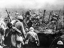
World War I or the First World War (28 July 1914 – 11 November 1918) was a global conflict between two coalitions: the Allies and the Central Powers. Fighting took place throughout Europe, the Middle East, Africa, the Pacific, and parts of Asia. One of the deadliest wars in history, it resulted in an estimated 9 million soldiers dead and 23 million wounded, plus up to 8 million civilian deaths from numerous causes including genocide. The movement of large numbers of troops and civilians during the war was a major factor in spreading the 1918 Spanish flu pandemic.
Increasing diplomatic tensions between the European great powers reached a breaking point on 28 June 1914, when a Bosnian Serb named Gavrilo Princip assassinated Archduke Franz Ferdinand, heir to the Austro-Hungarian throne. Austria-Hungary held Serbia responsible, and declared war on 28 July. Russia came to Serbia's defence, and by 4 August, Germany, France, and Britain were drawn into the war, with the Ottoman Empire joining in November of the same year. Germany's strategy in 1914 was to first defeat France, then transfer forces to the Russian front. However, this failed, and by the end of 1914, the Western Front consisted of a continuous line of trenches stretching from the English Channel to Switzerland. The Eastern Front was more dynamic, but neither side could gain a decisive advantage, despite costly offensives. As the war expanded to more fronts, Bulgaria, Italy, Romania, Greece and others joined in from 1915 onward. (Full article...) -
The "World Scientists' Warning to Humanity" was a document written in 1992 by Henry W. Kendall and signed by about 1,700 leading scientists. Twenty-five years later, in November 2017, 15,364 scientists signed "World Scientists' Warning to Humanity: A Second Notice" written by William J. Ripple and seven co-authors calling for, among other things, human population planning, and drastically diminishing per capita consumption of fossil fuels, meat, and other resources. The second notice has more scientist cosigners and formal supporters than any other journal article ever published. (Full article...)
-
The United Nations Educational, Scientific and Cultural Organization (UNESCO) is a specialized agency of the United Nations (UN) with the aim of promoting world peace and security through international cooperation in education, arts, sciences and culture. It has 194 member states and 12 associate members, as well as partners in the non-governmental, intergovernmental and private sector. Headquartered in Paris, France, UNESCO has 53 regional field offices and 199 national commissions.
UNESCO was founded in 1945 as the successor to the League of Nations' International Committee on Intellectual Cooperation. Its constitution establishes the agency's goals, governing structure, and operating framework. UNESCO's founding mission, which was shaped by the events of World War II, is to advance peace, sustainable development and human rights by facilitating collaboration and dialogue among nations. It pursues this objective through five major programme areas: education, natural sciences, social/human sciences, culture and communication/information. UNESCO sponsors projects that improve literacy, provide technical training and education, advance science, protect independent media and press freedom, preserve regional and cultural history, and promote cultural diversity. (Full article...) -
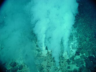
Evidence of possibly the oldest forms of life on Earth has been found in hydrothermal vent precipitates.
The earliest known life forms on Earth may be as old as 4.1 billion years old (or Ga) according to biologically fractionated graphite inside a single zircon grain in the Jack Hills range of Australia. The earliest evidence of life found in a stratigraphic unit, not just a single mineral grain, is the 3.7 Ga metasedimentary rocks containing graphite from the Isua Supracrustal Belt in Greenland. The earliest direct known life on land may be stromatolites which have been found in 3.480-billion-year-old geyserite uncovered in the Dresser Formation of the Pilbara Craton of Western Australia. Various microfossils of microorganisms have been found in 3.4 Ga rocks, including 3.465-billion-year-old Apex chert rocks from the same Australian craton region, and in 3.42 Ga hydrothermal vent precipitates from Barberton, South Africa. Much later in the geologic record, likely starting in 1.73 Ga, preserved molecular compounds of biologic origin are indicative of aerobic life. Therefore, the earliest time for the origin of life on Earth is at least 3.5 billion years ago, possibly as early as 4.1 billion years ago — not long after the oceans formed 4.5 billion years ago and after the formation of the Earth 4.54 billion years ago. (Full article...) -

The World Trade Organization (WTO) is an intergovernmental organization headquartered in Geneva, Switzerland that regulates and facilitates international trade. Governments use the organization to establish, revise, and enforce the rules that govern international trade in cooperation
with the United Nations System. The WTO is the world's largest international economic organization, with 164 member states representing over 98% of global trade and global GDP.
The WTO facilitates trade in goods, services and intellectual property among participating countries by providing a framework for negotiating trade agreements, which usually aim to reduce or eliminate tariffs, quotas, and other restrictions; these agreements are signed by representatives of member governments and ratified by their legislatures. It also administers independent dispute resolution for enforcing participants' adherence to trade agreements and resolving trade-related disputes. The organization prohibits discrimination between trading partners, but provides exceptions for environmental protection, national security, and other important goals. (Full article...) -
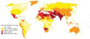
Map of global water stress (a symptom of water scarcity) in 2019. Water stress is the ratio of water use relative to water availability and is therefore a demand-driven scarcity.
Water scarcity (closely related to water stress or water crisis) is the lack of fresh water resources to meet the standard water demand. There are two type of water scarcity. One is physical. The other is economic water scarcity. Physical water scarcity is where there is not enough water to meet all demands. This includes water needed for ecosystems to function. Regions with a desert climate often face physical water scarcity. Central Asia, West Asia, and North Africa are examples of arid areas. Economic water scarcity results from a lack of investment in infrastructure or technology to draw water from rivers, aquifers, or other water sources. It also results from weak human capacity to meet water demand. Many people in Sub-Saharan Africa are living with economic water scarcity.
There is enough freshwater available globally and averaged over the year to meet demand. As such, water scarcity is caused by a mismatch between when and where people need water, and when and where it is available. One of the main causes of the increase in global water demand is the increase in the number of people. Others are the rise in living conditions, changing diets (to more animal products), and expansion of irrigated agriculture. Climate change (including droughts or floods), deforestation, water pollution and wasteful use of water can also mean there is not enough water. These variations in scarcity may also be a function of prevailing economic policy and planning approaches. (Full article...)


.svg)

General images -
-
 Earth's night-side upper atmosphere appearing from the bottom as bands of afterglow illuminating the troposphere in orange with silhouettes of clouds, and the stratosphere in white and blue. Next the mesosphere (pink area) extends to the orange and faintly green line of the lowest airglow, at about one hundred kilometers at the edge of space and the lower edge of the thermosphere (invisible). Continuing with green and red bands of aurorae stretching over several hundred kilometers. (from Earth)
 -
 An artist's impression of the Archean, the eon after Earth's formation, featuring round stromatolites, which are early oxygen-producing forms of life from billions of years ago. After the Late Heavy Bombardment, Earth's crust had cooled, its water-rich barren surface is marked by continents and volcanoes, with the Moon still orbiting Earth half as far as it is today, appearing 2.8 times larger and producing strong tides. (from Earth)
 -
 A composite image of artificial light emissions at night on a map of Earth (from Earth)
 -
Artist's impression of Earth during the later Archean, the largely cooled planetary crust and water-rich barren surface, marked by volcanoes and continents, features already round microbialites. The Moon, still orbiting Earth much closer than today and still dominating Earth's sky, produced strong tides. (from History of Earth)
-
 Artist's conception of Devonian flora (from History of Earth)
 -
 Vitruvian Man by Leonardo da Vinci epitomizes the advances in art and science seen during the Renaissance. (from History of Earth)
 -
 Tiktaalik, a fish with limb-like fins and a predecessor of tetrapods. Reconstruction from fossils about 375 million years old. (from History of Earth)
 -
 Benin Bronze head from Nigeria
 -
 Image of the physical world, captured by the Hubble Space Telescope (from World)
 -

-
 Great Pyramids of Giza, Egypt
 -
 An animation of the changing density of productive vegetation on land (low in brown; heavy in dark green) and phytoplankton at the ocean surface (low in purple; high in yellow) (from Earth)
 -

-

-

-
 Fall of the Berlin Wall, 1989
 -
 Graph showing range of estimated partial pressure of atmospheric oxygen through geologic time (from History of Earth)
 -

-
 Earth's land use for human agriculture in 2019 (from Earth)
 -
 Florence, birthplace of the Italian Renaissance
 -
 The pale orange dot, an artist's impression of the early Earth which might have appeared orange through its hazy methane rich prebiotic second atmosphere. Earth's atmosphere at this stage was somewhat comparable to today's atmosphere of Titan. (from History of Earth)
 -
 The replicator in virtually all known life is deoxyribonucleic acid. DNA is far more complex than the original replicator and its replication systems are highly elaborate. (from History of Earth)
 -
 Earth's axial tilt causing different angles of seasonal illumination at different orbital positions around the Sun (from Earth)
 -
 Ming dynasty section, Great Wall of China
 -
 Satellite time lapse imagery of Earth's rotation showing axis tilt (from Earth)
 -
 "Lucy", the first Australopithecus afarensis skeleton found, was only 1.06 m (3 ft 6 in) tall.
 -
 A 580 million year old fossil of Spriggina floundensi, an animal from the Ediacaran period. Such life forms could have been ancestors to the many new forms that originated in the Cambrian Explosion. (from History of Earth)
 -
 Standing Buddha from Gandhara, 2nd century CE
 -
 A map of heat flow from Earth's interior to the surface of Earth's crust, mostly along the oceanic ridges (from Earth)
 -
 Angkor Wat temple complex, Cambodia, early 12th century
 -
 A view of Earth with different layers of its atmosphere visible: the troposphere with its clouds casting shadows, a band of stratospheric blue sky at the horizon, and a line of green airglow of the lower thermosphere around an altitude of 100 km, at the edge of space (from Earth)
 -
 View of Earth from the Moon by the Lunar Reconnaissance Orbiter (from Earth)
 -
 Earth's western hemisphere showing topography relative to Earth's center instead of to mean sea level, as in common topographic maps (from Earth)
 -
 Chloroplasts in the cells of a moss (from History of Earth)
 -
 A reconstruction of Pannotia (550 Ma). (from History of Earth)
 -
 Ajloun Castle, Jordan
 -
 Peopling of the world, the Southern Dispersal scenario
 -
 A composite image of Earth, with its different types of surface discernible: Earth's surface dominating Ocean (blue), Africa with lush (green) to dry (brown) land and Earth's polar ice in the form of Antarctic sea ice (grey) covering the Antarctic or Southern Ocean and the Antarctic ice sheet (white) covering Antarctica. (from Earth)
 -

-
 An artist's rendering of a protoplanetary disk (from History of Earth)
 -
 Chennakesava Temple, Belur, India
 -
 Shanghai. China urbanized rapidly in the 21st century.
 -
 Artist's rendition of an oxinated fully-frozen Snowball Earth with no remaining liquid surface water. (from History of Earth)
 -
 Earth's history with time-spans of the eons to scale (from History of Earth)
 -
 Last Moon landing: Apollo 17 (1972)
 -

-
 Machu Picchu, Inca Empire, Peru
 -

-
 Artist's conception of Hadean Eon Earth, when it was much hotter and inhospitable to all forms of life. (from History of Earth)
 -
 Great Mosque of Kairouan, Tunisia, founded 670 CE
 -
 Tracy Caldwell Dyson, a NASA astronaut, observing Earth from the Cupola module at the International Space Station on 11 September 2010 (from Earth)
 -

-
Pale orange dot, an artist's impression of Early Earth, featuring its tinted orange methane-rich early atmosphere (from Earth)
-
 Change in average surface air temperature and drivers for that change. Human activity has caused increased temperatures, with natural forces adding some variability. (from Earth)
 -
 Cross-section through a liposome (from History of Earth)
 -

-
 A reconstruction of human history based on fossil data. (from History of Earth)
 -

-
 Notre-Dame de Paris, France
 -
 Japanese depiction of a Portuguese carrack. European maritime innovations led to proto-globalization.
 -
 Pangaea was a supercontinent that existed from about 300 to 180 Ma. The outlines of the modern continents and other landmasses are indicated on this map. (from History of Earth)
 -

-
 Artist's impression of a Hadean landscape with the relatively newly formed Moon still looming closely over Earth and both bodies sustaining strong volcanism. (from History of Earth)
 -
 A pillar at Göbekli Tepe
 -
 A computer-generated image mapping the prevalence of artificial satellites and space debris around Earth in geosynchronous and low Earth orbit (from Earth)
 -
 A 2012 artistic impression of the early Solar System's protoplanetary disk from which Earth and other Solar System bodies were formed (from Earth)
 -

-
 Persepolis, Achaemenid Empire, 6th century BCE
 -
 Olmec colossal head, now at the Museo de Antropología de Xalapa
 -

-
 Dinosaurs were the dominant terrestrial vertebrates throughout most of the Mesozoic (from History of Earth)
 -

-
 Geologic map of North America, color-coded by age. From most recent to oldest, age is indicated by yellow, green, blue, and red. The reds and pinks indicate rock from the Archean.
 -
 Artist's impression of the enormous collision that probably formed the Moon (from History of Earth)
 -
 A schematic view of Earth's magnetosphere with solar wind flowing from left to right (from Earth)
 -
 Obelisk of Axum, Ethiopia
 -

-
 Yggdrasil, an attempt to reconstruct the Norse world tree which connects the heavens, the world, and the underworld. (from World)
 -
 Lithified stromatolites on the shores of Lake Thetis, Western Australia. Archean stromatolites are the first direct fossil traces of life on Earth. (from History of Earth)
 -
 Empires of the world in 1898
 -

-
 Battle during the 1281 Mongol invasion of Japan
 -
 First airplane, the Wright Flyer, flew on 17 December 1903.
 -
 Taj Mahal, Mughal Empire, India
 -
 Trilobites first appeared during the Cambrian period and were among the most widespread and diverse groups of Paleozoic organisms. (from History of Earth)
 -
 A banded iron formation from the 3.15 Ga Moodies Group, Barberton Greenstone Belt, South Africa. Red layers represent the times when oxygen was available; gray layers were formed in anoxic circumstances. (from History of Earth)
 -
 A view of Earth with its global ocean and cloud cover, which dominate Earth's surface and hydrosphere; at Earth's polar regions, its hydrosphere forms larger areas of ice cover. (from Earth)
 -
 An artist's impression of ice age Earth at glacial maximum. (from History of Earth)


.jpg)

.jpg)


.jpeg)


.svg)


.jpg)


Megacities of the world -

Moscow is the capital and largest city of Russia. The city stands on the Moskva River in Central Russia, with a population estimated at over 13 million residents within the city limits, over 18.8 million residents in the urban area, and over 21.5 million residents in its metropolitan area. The city covers an area of 2,511 square kilometers (970 sq mi), while the urban area covers 5,891 square kilometers (2,275 sq mi), and the metropolitan area covers over 26,000 square kilometers (10,000 sq mi). Moscow is among the world's largest cities, being the most populous city in its entirety in Europe, the largest urban and metropolitan area in Europe, and the largest city by land area on the European continent.
First documented in 1147, Moscow grew to serve as the capital of the Grand Duchy of Moscow. When the Tsardom of Russia was proclaimed, Moscow remained the political and economic center for most of its history. Under the reign of Peter the Great, the Russian capital was moved to the newly founded city of Saint Petersburg in 1712, decreasing Moscow's influence. Following the Russian Revolution and the establishment of the Russian SFSR, the capital was moved back to Moscow in 1918, where it later became the political center of the Soviet Union. In the aftermath of the dissolution of the Soviet Union, Moscow remained the capital city of the newly established Russian Federation. (Full article...)Did you know -

- ... that a large basin on Neptune's moon Triton may have once been filled with liquid water cryolava, similar to how liquid silicates fill lava lakes on Earth?
- ... that Earth 300 has designed a climate research vessel that would include a molten salt reactor and a quantum computer?
- ... that the heritage-registered Weston House, designed by architect Cecil Wood for George Weston, was damaged in a series of earthquakes in Christchurch and later demolished?
- ... that Venla Luukkonen is the first Finnish person to win the World IBJJF Jiu-Jitsu Championship at black belt level?
- ... that the freshwater leech Haemopis sanguisuga sometimes emerges from the water to hunt for earthworms?
- ... that William J. Murphy's presidency of Boston College began 16 days before the start of World War II and concluded five days after hostilities ended?
- ... that the global coalition to save Abu Simbel, Philae and many other temples led to the creation of the modern list of World Heritage Sites?
- ... that Russian-Jewish medical student Leo Osnas won the first Cross of St. George of the First World War by saving his regiment's colours from capture?
Countries of the world -

Bulgaria, officially the Republic of Bulgaria, is a country in Southeast Europe. Located west of the Black Sea and south of the Danube river, Bulgaria is bordered by Greece and Turkey to the south, Serbia and North Macedonia to the west, and Romania to the north. It covers a territory of 110,994 square kilometres (42,855 sq mi) and is the 16th largest country in Europe. Sofia is the nation's capital and largest city; other major cities include Burgas, Plovdiv, and Varna.
One of the earliest societies in the lands of modern-day Bulgaria was the Neolithic Karanovo culture, which dates back to 6,500 BC. In the 6th to 3rd century BC, the region was a battleground for ancient Thracians, Persians, Celts and Macedonians; stability came when the Roman Empire conquered the region in AD 45. After the Roman state splintered, tribal invasions in the region resumed. Around the 6th century, these territories were settled by the early Slavs. The Bulgars, led by Asparuh, attacked from the lands of Old Great Bulgaria and permanently invaded the Balkans in the late 7th century. They established the First Bulgarian Empire, victoriously recognised by treaty in 681 AD by the Byzantine Empire. It dominated most of the Balkans and significantly influenced Slavic cultures by developing the Cyrillic script. The First Bulgarian Empire lasted until the early 11th century, when Byzantine emperor Basil II conquered and dismantled it. A successful Bulgarian revolt in 1185 established a Second Bulgarian Empire, which reached its apex under Ivan Asen II (1218–1241). After numerous exhausting wars and feudal strife, the empire disintegrated and in 1396 fell under Ottoman rule for nearly five centuries. (Full article...)
The New 7 Wonders of the World was a campaign started in 2001 to choose Wonders of the World from a selection of 200 existing monuments. The popularity poll via free Web-based voting and small amounts of telephone voting was led by Canadian-Swiss Bernard Weber and organized by the New 7 Wonders Foundation (N7W) based in Zurich, Switzerland, with winners announced on 7 July 2007 in Lisbon, at Estádio da Luz. The poll was considered unscientific partly because it was possible for people to cast multiple votes. According to John Zogby, founder and current President/CEO of the Utica, New York–based polling organization Zogby International, New 7 Wonders Foundation drove "the largest poll on record".
The program drew a wide range of official reactions. Some countries touted their finalist and tried to get more votes cast for it, while others downplayed or criticized the contest. After supporting the New 7 Wonders Foundation at the beginning of the campaign by providing advice on nominee selection, the United Nations Educational, Scientific, and Cultural Organization (UNESCO), bound by its bylaws to record and give equal status to all World Heritage Sites, distanced itself from the undertaking in 2001 and again in 2007. (Full article...)Related portals
Protected areas of the world -
-

Centre for Nature Education at the Białowieża National Park, Poland
Protected areas of Poland include the following categories, as defined by the Act on Protection of Nature (Polish: Ustawa o ochronie przyrody) of 16 April 2004, by the Polish Parliament: (Full article...) -
Protected areas of Slovenia include one national park (Slovene: narodni park), three regional parks (regijski park), several natural parks (krajinski park), and hundreds of natural monuments (naravni spomenik) and monuments of designed nature (spomenik oblikovane narave). They cover about 12.5% of the Slovenian territory. Under the Wild Birds Directive, 26 sites totalling roughly 25% of the nation's land are "Special Protected Areas"; the Natura 2000 proposal would increase the totals to 260 sites and 32% of national territory. (Full article...)
-
Bihar is a state in East India. It is bounded by Uttar Pradesh to the west, Nepal to the north, West Bengal to the east and Jharkhand to the south. About 7% of the state is protected forest area. (Full article...)
-
The following list of protected areas of British Columbia includes all federally and provincially protected areas within the Canadian province of British Columbia. As of 2015, approximately 15.46% of the province's land area and 3.17% of the province's waters are protected. (Full article...)
-
-

Map of Georgia
The protected areas of Georgia cover almost one million acres (4,000 km2) of the state. These areas are managed by different federal and state level authorities and receive varying levels of protection. Some areas are managed as wilderness while others are operated with acceptable commercial exploitation. On the Federal level, Georgia contains 1 Biosphere Reserve, 15 National Park Service Managed Sites, 1 National Forest and 8 Wildlife Refuges. Georgia is home to 63 state parks, 48 of which are state parks and 15 that are National Historic Sites, and many state wildlife preserves, under the supervision of the Georgia Department of Parks and Recreation, a division of the Georgia Department of Natural Resources. (Full article...) -
-

Cranes at Sevan National Park
This is a list of protected areas in Armenia that are categorized as follows: 4 national parks, 3 state reserves, 27 state sanctuaries and 5 botanical gardens. (Full article...) -
Papua New Guinea is home to several protected areas, which receive protection because of their environmental, cultural or similar value.
The total area of Papua New Guinea protected territories is 14,330 km2 (5,530 sq mi), which amounts to approximately 3.07% of the country's territory. The total number of protected areas as 2018 is 71. (Full article...) -
The protected areas of Nepal cover mainly forested land and are located at various altitudes in the Terai, in the foothills of the Himalayas and in the mountains, thus encompassing a multitude of landscapes and preserving a vast biodiversity in the Palearctic and Indomalayan realms.
Nepal covers 147,181 km2 (56,827 sq mi) in the central part of the Himalayas. Altitudes range from 67 m (220 ft) in the south-eastern Terai to 8,848 m (29,029 ft) at Mount Everest within a short horizontal span. This extreme altitudinal gradient has resulted in 11 bio-climatic zones ranging from lower tropical below 500 m (1,600 ft) to nival above 5,000 m (16,000 ft) in the High Himalayas, encompassing nine terrestrial ecoregions with 36 vegetation types.
Additionally, nine Ramsar sites were declared between 1988 and 2008. Two wildlife reserves were declared as national parks in 2017. (Full article...) -
Protected areas of Tasmania consist of protected areas located within Tasmania and its immediate onshore waters, including Macquarie Island. It includes areas of crown land (withheld land) managed by Tasmanian Government agencies as well as private reserves. As of 2016, 52% of Tasmania's land area has some form of reservation classification, the majority is managed by the Tasmania Parks & Wildlife Service (about 42% of total Tasmanian land area). Marine protected areas cover about 7.9% of state waters.
Within each classification of reserve there may be a variation of IUCN categories Australia is a signatory to the Convention of Biological Diversity and as such has obligations to report the status of its National Reserve System.IUCN provides on its website a prescription for activities consistent with the categorisation system. Changes made to the Nature Conservation Act 2002 in 2014 permit timber harvesting. These changes made in addition to the already established right to access minerals means that many of the IUCN categorisations assigned to individual reserves in Tasmania are no longer fit for purpose. In addition many reserves have had their reserve status downgraded from a class excluding timber harvesting and mineral extraction to ones where these activities are now permitted. This mis-application of the IUCN protected area categories needs to be remedied or the reserves protected land class under the Nature Conservation Act 2002 should be adjusted to reflect its currently assigned IUCN category. (Full article...) -
The Protected areas of Portugal (Portuguese: Áreas protegidas de Portugal) are classified under a legal protection statute that allows for the adequate protection and maintenance of biodiversity, while providing services for ecosystem that maintains the natural and geological patrimony. (Full article...)
-
Illinois has a variety of protected areas, including over 123 state-protected areas, dozens of federally protected areas, hundreds of county-level and municipal park areas. Illinois also contains sites designated as internationally important protected areas. These multiple levels of protection contribute to a statewide network of numerous recreation opportunities and conservation schemes, sometimes in a small area. For example, DeKalb County contains a 1,000-acre (4.0 km2) forest preserve system and a 1,500-acre (6.1 km2) state park (Shabbona Lake State Park); within DeKalb County, the DeKalb Park District in the City of DeKalb has a 700-acre (2.8 km2) park system. (Full article...)
-

Grand Canyon of Yellowstone
The protected areas of the United States are managed by an array of different federal, state, tribal and local level authorities and receive widely varying levels of protection. Some areas are managed as wilderness, while others are operated with acceptable commercial exploitation. , the 42,826 protected areas covered 1,235,486 km2 (477,024 sq mi), or 13 percent of the land area of the United States. This is also one-tenth of the protected land area of the world. The U.S. also had a total of 871 National Marine Protected Areas, covering an additional 1,240,000 sq mi (3,200,000 km2), or 26 percent of the total marine area of the United States. (Full article...) -
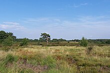
Heathland at the Hoge Kempen National Park
There are numerous protected areas in Belgium with a wide variety of types, protection levels and sizes. The below list gives an overview of the most important protected areas. (Full article...)


Selected world maps
-
 Mollweide projection of the world
 -
 The world map by Gerardus Mercator (1569), the first map in the well-known Mercator projection
 -
 A plate tectonics map with volcano locations indicated with red circles
 -
 The Goode homolosine projection is a pseudocylindrical, equal-area, composite map projection used for world maps.
 -
 Index map from the International Map of the World (1:1,000,000 scale)
 -
 Time zones of the world
 -
 Only a few of the largest large igneous provinces appear (coloured dark purple) on this geological map, which depicts crustal geologic provinces as seen in seismic refraction data
 -
 United Nations Human Development Index map by country (2016)
 -
 1516 map of the world by Martin Waldseemüller


World records
- List of Olympic records in athletics
- List of world records in athletics
- List of junior world records in athletics
- List of world records in masters athletics
- List of world youth bests in athletics
- List of IPC world records in athletics
- List of world records in canoeing
- List of world records in chess
- List of cycling records
- List of world records in track cycling
- List of world records in finswimming
- List of world records in juggling
- List of world records in rowing
- List of world records in speed skating
- List of world records in swimming
- List of IPC world records in swimming
- List of world records in Olympic weightlifting
Topics

Continents of Earth | ||||||||
|---|---|---|---|---|---|---|---|---|
| ||||||||
| ||||||||
| ||||||||


| Cenozoic Era (present–66.0 Ma) |
| ||||||||||||
|---|---|---|---|---|---|---|---|---|---|---|---|---|---|
| Mesozoic Era (66.0–252 Ma) |
| ||||||||||||
| Paleozoic Era (252–539 Ma) |
| ||||||||||||
| Proterozoic Eon (539 Ma–2.5 Ga) |
| ||||||||||||
| Archean Eon (2.5–4 Ga) | |||||||||||||
| Hadean Eon (4–4.6 Ga) | |||||||||||||
ka = kiloannum (thousands years ago); Ma = megaannum (millions years ago); Ga = gigaannum (billions years ago). See also: Geologic time scale • | |||||||||||||
| Locations | ||
|---|---|---|
| Related | ||

| |||||||||||||||||||
| |||||||||||||||||||
| |||||||||||||||||||

Economic classification of countries | |||||
|---|---|---|---|---|---|
| Three-World Model | |||||
| Gross domestic product (GDP) |
| ||||
| Gross national income (GNI) | |||||
| Wages | |||||
| Wealth | |||||
| Other national accounts | |||||
| Human development | |||||
| Digital divide | |||||
| Net international investment position (NIIP) | |||||
| Technological |
| ||||
|---|---|---|---|---|---|
| Sociological | |||||
| Ecological |
| ||||
| Biological |
| ||||
| Astronomical | |||||
| Eschatological |
| ||||
| Others |
| ||||
| Fictional | |||||
| Organizations | |||||
Categories

Wikimedia
The following Wikimedia Foundation sister projects provide more on this subject:
-
 Commons
Free media repository -
 Wikibooks
Free textbooks and manuals -
 Wikidata
Free knowledge base -
 Wikinews
Free-content news -
 Wikiquote
Collection of quotations -
 Wikisource
Free-content library -
 Wikispecies
Directory of species -
 Wikiversity
Free learning tools -
 Wikivoyage
Free travel guide -
 Wiktionary
Dictionary and thesaurus


