ကြိုဆိုပါတယ်။ / Welcome to the Myanmar Portal 

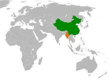
Myanmar, officially the Republic of the Union of Myanmar and also known as Burma (the official name until 1989), is a country in Southeast Asia. It is the largest country by area in Mainland Southeast Asia and has a population of about 55 million. It is bordered by Bangladesh and India to its northwest, China to its northeast, Laos and Thailand to its east and southeast, and the Andaman Sea and the Bay of Bengal to its south and southwest. The country's capital city is Naypyidaw, and its largest city is Yangon (formerly Rangoon).
Myanmar is a member of the East Asia Summit, Non-Aligned Movement, ASEAN, and BIMSTEC, but it is not a member of the Commonwealth of Nations despite once being part of the British Empire. Myanmar is a Dialogue Partner of the Shanghai Cooperation Organization. The country is very rich in natural resources, such as jade, gems, oil, natural gas, teak and other minerals, as well as also endowed with renewable energy, having the highest solar power potential compared to other countries of the Great Mekong Subregion. However, Myanmar has long suffered from instability, factional violence, corruption, poor infrastructure, as well as a long history of colonial exploitation with little regard to human development. In 2013, its GDP (nominal) stood at US$56.7 billion and its GDP (PPP) at US$221.5 billion. The income gap in Myanmar is among the widest in the world, as a large proportion of the economy is controlled by cronies of the military junta. Myanmar is one of the least developed countries; as of 2020, according to the Human Development Index, it ranks 147 out of 189 countries in terms of human development, the lowest in Southeast Asia. Since 2021, more than 600,000 people were displaced across Myanmar due to the surge in violence post-coup, with more than 3 million people in dire need of humanitarian assistance. (Full article...)
Selected articles -
-


The Provisional Government of the Republic of the Union of Myanmar (Burmese: ပြည်ထောင်စုသမ္မတမြန်မာနိုင်ငံတော် အာဏာသိမ်းခေါင်းဆောင်), is the executive body of Myanmar under the current military junta, the State Administration Council. On 1 August 2021, it replaced the Management Committee of the State Administration Council, which had been in place since 19 February 2021, following the 2021 Myanmar coup d'état. Some ministers were appointed by Min Aung Hlaing immediately following the coup on 1 February, in his capacity as Commander-in-Chief of Defence Services exercising emergency powers.
Due to the state of emergency, the cabinet is led by Prime Minister Min Aung Hlaing rather than Acting President Myint Swe, despite the president being the constitutional head of government. (Full article...) -
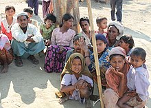
The Rohingya people (/roʊˈhɪndʒə, -ɪŋjə/; Rohingya: 𐴌𐴗𐴥𐴝𐴙𐴚𐴒𐴙𐴝, IPA: [rʊˈɜi̯ɲ.ɟə]) are a stateless Indo-Aryan ethnic group who predominantly follow Islam and reside in Rakhine State, Myanmar. Before the Rohingya genocide in 2017, when over 740,000 fled to Bangladesh, an estimated 1.4 million Rohingya lived in Myanmar. Described by journalists and news outlets as one of the most persecuted minorities in the world, the Rohingya are denied citizenship under the 1982 Myanmar nationality law. There are also restrictions on their freedom of movement, access to state education and civil service jobs. The legal conditions faced by the Rohingya in Myanmar have been compared to apartheid by some academics, analysts and political figures, including Nobel laureate Bishop Desmond Tutu, a South African anti-apartheid activist. The most recent mass displacement of Rohingya in 2017 led the International Criminal Court to investigate crimes against humanity, and the International Court of Justice to investigate genocide.
The Rohingya maintain they are indigenous to western Myanmar with a heritage of over a millennium and influence from the Arabs, Mughals, and Portuguese. The community claims it is descended from people in precolonial Arakan and colonial Arakan; historically, the region was an independent kingdom between Southeast Asia and the Indian subcontinent. The Myanmar government considers the Rohingya as British colonial and postcolonial migrants from Chittagong in Bangladesh. It argues that a distinct precolonial Muslim population is recognized as Kaman, and that the Rohingya conflate their history with the history of Arakan Muslims in general to advance a separatist agenda. In addition, Myanmar's government does not recognise the term "Rohingya" and prefers to refer to the community as "Bengali". Rohingya campaign groups and human rights organizations demand the right to "self-determination within Myanmar". (Full article...) -
Yenangyaung (Burmese: ရေနံချောင်း; literally "stream of oil") is a city in the Magway Region of central Myanmar, located on the Irrawaddy River and 363 miles from Yangon. Until 1974, it remained the capital city of both Minbu Division (now Magway Division) and Yenangyaung District. The population of Yenanchaung was 45,120 according to the 2014 census, but it reached 49,938 in September 2020. This makes it the fourth-largest city in the Magway Region, after Pakokku, Magway and Aunglan. General Aung San received his secondary education in this city. (Full article...) -

Inle Lake (Burmese: အင်းလေးကန်; MLCTS: ang: le: kan, [ʔɪ́ɰ̃lé kàɰ̃]), a freshwater lake located in the Nyaungshwe Township of Shan State, part of Shan Hills in Myanmar (Burma). It is the second largest lake in Myanmar, with an estimated surface area of 44.9 square miles (116 km2), and one of the highest at an elevation of 2,900 feet (880 m). During the dry season, the average water depth is 7 feet (2.1 m), with the deepest point being 12 feet (3.7 m). During the rainy season, this can increase by 5 feet (1.5 m).
The watershed area for the lake lies to a large extent to the north and west of the lake. The lake drains through the Nam Pilu or Balu Chaung on its southern end. There is also a hot spring on its northwestern shore. (Full article...) -
Censorship in Myanmar (also called Burma) results from government policies in controlling and regulating certain information, particularly on religious, ethnic, political, and moral grounds.
Freedom of speech and the press are not guaranteed by law. Many colonial-era laws regulating the press and information continue to be used. Until August 2012, every publication (including newspaper articles, cartoons, advertisements, and illustrations) required pre-approval by the Press Scrutiny and Registration Division (PSRB) of the Ministry of Information. However, the 2011–2012 Burmese political reforms signalled significant relaxations of the country's censorship policies and in August 2012 the Ministry of Information lifted the requirement that print media organisations submit materials to the government prior to publication. (Full article...) -
China–Myanmar relations (Chinese: 中缅关系; Burmese: တရုတ်မြန်မာဆက်ဆံရေး) are the international relations between the People's Republic of China and Myanmar. China and Myanmar have active bilateral relations with each other. The relation is often described as a pauk-phaw relationship (Burmese: ပေါက်ဖော်), based a Burmese term for kinsfolk that implicates special asymmetric obligations between the two countries.
Generally, China has maintained positive relationships with both military and elected governments in Myanmar. Bilateral relations between China and Myanmar have also faced difficulties due to alleged Chinese backing of rebels in Myanmar's territories. In recent years, the relations between China and Myanmar have faced some problems due to ongoing clashes between ethnic Chinese rebels and the Myanmar military near the China–Myanmar border. (Full article...) -
General elections were held in Myanmar on 8 November 2015, with the National League for Democracy winning a supermajority of seats in the combined national parliament. Voting occurred in all constituencies, excluding seats appointed by the military, to select Members of Assembly to seats in both the upper house (the House of Nationalities) and the lower house (the House of Representatives) of the Assembly of the Union, and State and Region Hluttaws. Ethnic Affairs Ministers were also elected by their designated electorates on the same day, although only select ethnic minorities in particular states and regions were entitled to vote for them.
These polls were the first openly contested election held in the country since 1990, which was annulled by the military government after the National League for Democracy's (NLD) victory. The poll was preceded by the 2010 general election, which was marred by a boycott and widespread allegations of systematic fraud by the victorious Union Solidarity and Development Party (USDP). (Full article...) -

The picture shows the location of Myanmar in Southeast Asia.
The geology of Myanmar is shaped by dramatic, ongoing tectonic processes controlled by shifting tectonic components as the Indian plate slides northwards and towards Southeast Asia. Myanmar spans across parts of three tectonic plates (the Indian Plate, Burma microplate and Shan Thai Block) separated by north-trending faults. To the west, a highly oblique subduction zone separates the offshore Indian plate from the Burma microplate, which underlies most of the country. In the center-east of Myanmar, a right lateral strike slip fault extends from south to north across more than 1,000 km (620 mi). These tectonic zones are responsible for large earthquakes in the region. The India-Eurasia plate collision which initiated in the Eocene provides the last geological pieces of Myanmar, and thus Myanmar preserves a more extensive Cenozoic geological record as compared to records of the Mesozoic and Paleozoic eras. Myanmar is physiographically divided into three regions: the Indo-Burman Range, Myanmar Central Belt and the Shan Plateau; these all display an arcuate shape bulging westwards. The varying regional tectonic settings of Myanmar not only give rise to disparate regional features, but they also foster the formation of petroleum basins and a diverse mix of mineral resources. (Full article...) -
Buddhism (Burmese: ဗုဒ္ဓဘာသာ), specifically Theravāda Buddhism (Burmese: ထေရဝါဒဗုဒ္ဓဘာသာ), is the official and state religion of Myanmar since 1961, and practiced by nearly 90% of the population. It is the most religious Buddhist country in terms of the proportion of monks in the population and proportion of income spent on religion. Adherents are most likely found among the dominant Bamar people, Shan, Rakhine, Mon, Karen, and Chinese who are well integrated into Burmese society. Monks, collectively known as the sangha (community), are venerated members of Burmese society. Among many ethnic groups in Myanmar, including the Bamar and Shan, Theravada Buddhism is practiced in conjunction with the worship of nats, which are spirits who can intercede in worldly affairs.
Regarding the practice of Buddhism, two popular practices stand out: merit-making and vipassanā meditation. There is also the less popular weizza path. Merit-making is the most common path undertaken by Burmese Buddhists. This path involves the observance of the Five precepts and accumulation of good merit through charity (dana, often to monks) and good deeds to obtain a favorable rebirth. The meditation path, which has gained ground since the early 1900s, is a form of Buddhist meditation which is seen as leading to awakening and can involve intense meditation retreats. The weizza path is an esoteric system of occult practices (such as recitation of spells, samatha and alchemy) believed to lead to life as a weizza (Burmese: ဝိဇ္ဇာ Pali: vijjā), a semi-immortal and supernatural being who awaits the appearance of the future Buddha, Maitreya (Arimeitaya). (Full article...) -
Hkakaborazi National Park is a national park in northern Myanmar with an area of 1,472 sq mi (3,810 km2). It was established in 1998.
It surrounds Hkakabo Razi, the highest mountain in the country.
It ranges in elevation from 2,950 to 18,730 ft (900 to 5,710 m) comprising evergreen forest and mixed deciduous forests in Nogmung Township, Kachin State. It is managed by the Nature and Wildlife Conservation Division.
It is contiguous with Bumhpa Bum Wildlife Sanctuary and Hukaung Valley Wildlife Sanctuary. These protected areas together with Hponkanrazi Wildlife Sanctuary comprise the largest continuous expanse of natural forest called the Northern Forest Complex stretching over an area of 11,624 sq mi (30,110 km2). Its objective is to conserve the biodiversity of the Ayeyarwady and Chindwin river basins. (Full article...)


_(cropped).jpg)

.jpg)


Did you know (auto-generated) -

- ... that the Burmese Buddhist monk Sagyo Thu-Myat successfully lobbied for the recalibration of the Burmese calendar?
- ... that squatters in Myanmar were punished for protesting against the 2021 coup d'état by being evicted?
- ... that Rolling Stone named Mission of Burma's "Academy Fight Song" as one of the 100 greatest debut singles of all time?
- ... that the Myanmar Coast Guard was initially proposed as a civilian law enforcement agency before being established as a branch of the military three years later?
- ... that the Myanmar Photo Archive (example photograph shown) revealed "a side of modern Myanmar that, until very recently, remained hidden in dusty attics"?
- ... that Aung Myo Min, Union Minister of Human Rights for the National Unity Government of Myanmar, is the country's first openly LGBT minister?
- ... that the Burmese and South Korean first ladies held their first informal conversation 44 years after the establishment of bilateral relations between the two countries?
- ... that former Burmese actress Honey Nway Oo turned rebel and took up arms against the military junta following the 2021 Myanmar coup d'état?
Related portals and projects
General images -
-
 Grandfather Island, Dawei (from Geography of Myanmar)
 -
 Boxing match, 19th-century watercolour (from Culture of Myanmar)
 -
 Mount Popa, a dormant volcano in the Central Lowlands (from Geography of Myanmar)
 -
 A theatrical performance of the Mon dance (from Culture of Myanmar)
 -

-
 A large fracture on the Mingun Pahtodawgyi caused by the 1839 Ava earthquake. (from Geography of Myanmar)
 -
 Myinhkin thabin - equestrian sport (from Culture of Myanmar)
 -
 British soldiers remove their shoes at the entrance of Shwedagon Pagoda. To the left, a sign reads "Foot wearing is strictly prohibited" in Burmese, English, Tamil, and Urdu. (from Culture of Myanmar)
 -
 British soldiers dismantling cannons belonging to King Thibaw's forces, Third Anglo-Burmese War, Ava, 27 November 1885. Photographer: Hooper, Willoughby Wallace (1837–1912). (from History of Myanmar)
 -
 The restored Taungoo or Nyaungyan dynasty c. 1650 CE. (from History of Myanmar)
 -
 Mountains near Pindaya on the Shan Plateau (from Geography of Myanmar)
 -
 Pagan Kingdom during Narapatisithu's reign. Burmese chronicles also claim Kengtung and Chiang Mai. Core areas shown in darker yellow. Peripheral areas in light yellow. Pagan incorporated key ports of Lower Burma into its core administration by the 13th century. (from History of Myanmar)
 -
 Jade Mine in Hpakant (from Geography of Myanmar)
 -
 Vegetable stall on the roadside at the Madras Lancer Lines, Mandalay, January 1886. Photographer: Hooper, Willoughby Wallace (1837–1912). (from History of Myanmar)
 -
 Political Map of Burma (Myanmar) c. 1450 CE. (from History of Myanmar)
 -
 A group of Buddhist worshipers at Shwedagon Pagoda, an important religious site for Burmese Buddhists (from Culture of Myanmar)
 -
 Former US President Barack Obama poses barefoot on the grounds of Shwedagon Pagoda, one of Myanmar's major Buddhist pilgrimage sites. (from Culture of Myanmar)
 -
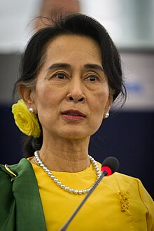
 Protesters in Yangon carrying signs reading "Free Daw Aung San Suu Kyi" on 8 February 2021. (from History of Myanmar)
 -
 A wide range of Burmese lacquerware from Bagan (from Culture of Myanmar)
 -

-
 A bull fight, 19th-century watercolour (from Culture of Myanmar)
 -
 The shores of Irrawaddy River at Nyaung-U, Bagan (from Geography of Myanmar)
 -
 The paddle steamer Ramapoora (right) of the British India Steam Navigation Company on the Rangoon river having just arrived from Moulmein. 1895. Photographers: Watts and Skeen (from History of Myanmar)
 -
 19th-century funeral cart and spire, which would form part of the procession from the home to the place of cremation (from Culture of Myanmar)
 -
 Aung San Suu Kyi addresses crowds at the NLD headquarters shortly after her release. (from History of Myanmar)
 -
 Salween river at Mae Sam Laep on the Thai-Myanmar border (from Geography of Myanmar)
 -
 Hlei pyaingbwè - a Burmese regatta (from Culture of Myanmar)
 -
 Myanmar (Burma) map of Köppen climate classification (from Geography of Myanmar)
 -
 Aerial view of a burned Rohingya village in Rakhine state, Myanmar, September 2017 (from History of Myanmar)
 -

-
 A wedding procession, with the groom and bride dressed in traditional Burmese wedding clothes, reminiscent of royal attire (from Culture of Myanmar)
 -
 British soldiers on patrol in the ruins of the Burmese town of Bahe during the advance on Mandalay, January 1945. (from History of Myanmar)
 -

-
 Sculpture of Myanmar mythical lion (from Culture of Myanmar)
 -
 Temples at Mrauk U, was the capital of the Mrauk U Kingdom, which ruled over what is now Rakhine State. (from History of Myanmar)
 -
 Protesters in Yangon with a banner that reads non-violence: national movement in Burmese, in the background is Shwedagon Pagoda. (from History of Myanmar)
 -
 Two female musicians play the saung at a performance in Mandalay. (from Culture of Myanmar)
 -
 Portuguese ruler and soldiers mounting an Elephant. Philips, Jan Caspar (draughtsman and engraver) (from History of Myanmar)
 -
 Saint Mary's Cathedral in Downtown Yangon is the largest Roman Catholic cathedral in Burma. (from Culture of Myanmar)
 -
 Recorder's Court on Sule Pagoda Road, with the Sule Pagoda at the far end, Rangoon, 1868. Photographer: J. Jackson. (from History of Myanmar)


_headquarter.jpg)


Major topics
Categories

More topics

Associated Wikimedia
The following Wikimedia Foundation sister projects provide more on this subject:
-
 Commons
Free media repository -
 Wikibooks
Free textbooks and manuals -
 Wikidata
Free knowledge base -
 Wikinews
Free-content news -
 Wikiquote
Collection of quotations -
 Wikisource
Free-content library -
 Wikiversity
Free learning tools -
 Wikivoyage
Free travel guide -
 Wiktionary
Dictionary and thesaurus


