The Hampshire Portal


Hampshire (/ˈhæmpʃər/, /-ʃɪər/ ; abbreviated to Hants.) is a ceremonial county in South East England. It is bordered by Berkshire to the north, Surrey and West Sussex to the east, the Isle of Wight across the Solent to the south, Dorset to the west, and Wiltshire to the north-west. The cities of Portsmouth and Southampton are the largest settlements and the county town is the city of Winchester.
The county has an area of 3,769 km2 (1,455 sq mi) and a population of 1,844,245, making it the 5th-most populous in England. The South Hampshire built-up area in the south-east of the county has a population of 855,569 and contains the cities of Southampton (269,781) and Portsmouth (208,100). In the north-east, the Farnborough/Aldershot conurbation extends into Berkshire and Surrey and has a population of 252,937. The next-largest settlements are Basingstoke (113,776), Andover (50,887), and Winchester (45,184). The centre and south-west of the county are rural. For local government purposes Hampshire comprises a non-metropolitan county, with eleven districts, and two unitary authority areas: Portsmouth and Southampton. The county historically contained the towns of Bournemouth and Christchurch, which are now part of Dorset, and the Isle of Wight.
Undulating hills characterise much of the county. A belt of chalk crosses the county from north-west, where it forms the Hampshire Downs, to south-east, where it is part of the South Downs. The county's major rivers rise in these hills; the Loddon and Wey drain north, into the Thames, and the Itchen and Test flow south into Southampton Water, a large estuary. In the south-east are Portsmouth Harbour, Langstone Harbour, and the western edge of Chichester Harbour, three large rias. The south-west contains the New Forest, which includes pasture, heath, and forest and is of the largest expanses of ancient woodland remaining in England.
Settled about 14,000 years ago, Hampshire's recorded history dates to Roman Britain, when its chief town was Venta Belgarum (now Winchester). The county was recorded in Domesday Book as divided into 44 hundreds. From the 12th century, the ports settlements grew due to increasing trade with the European mainland resulting from the wool and cloth, fishing, and shipbuilding industries. This meant by the 16th century, Southampton had become more populous than Winchester. In 20th century conflicts, including World War One and Two, Hampshire played a crucial military role due to its ports. (Full article...)
Selected article

The River Rother flows from Empshott in Hampshire, England, to Stopham in West Sussex, where it joins the River Arun. At 52 kilometres (32 mi) long, most of the river lies within West Sussex except for the first 10 kilometres (6.2 mi) which lie in Hampshire. The upper river, from its source to Midhurst, has been used to power watermills, with the earliest recorded use being in 1086, when the Domesday survey was conducted. Although none are still operational, many of the buildings which housed the mills still exist, and in some cases, still retain their milling machinery. This upper section is also noted for a number of early bridges, which have survived since their construction in the fifteenth, sixteenth and seventeenth centuries.
The lower river, from Midhurst to its junction with the River Arun, has been used for navigation. Boats used the section from the Arun to Fittleworth following improvements made to the Arun in 1615, and after the Arun Navigation was completed in 1790, the Earl of Egremont made the river navigable up to Midhurst by constructing eight locks and some small cuts. The work was completed in 1794, and many of the bridges built at that time still survive. With the opening of the Mid-Sussex Railway branch to Midhurst in 1859, traffic declined, and commercial use of the river had ceased by the 1880s. Pleasure boats continued to be used on the river for many years, and published accounts of journeys along the decaying navigation appeared in 1914 and 1920. The navigation was officially abandoned in 1936, after an undergraduate pointed out that it was still a public right of way.
The river flows through the South Downs National Park, and is a designated Site of Nature Conservation Importance, in recognition of its value for wildlife. It supports a wide range of fish, and its upper reaches are the only location in Sussex where native white clawed crayfish can be found. The quality of the water is generally good, and the river is measured at four gauging stations, three on the main channel, and one of the River Lod, just before its junction with the Rother. Water from the underlying Lower Greensand aquifer and the adjacent chalk aquifer helps to maintain the flows during the summer months, despite the fact that large volumes are abstracted from both the aquifers and the river for the public water supply. (Full article...)
Selected images
-
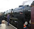 A train on the Watercress Line (from Portal:Hampshire/Selected pictures)
 -

-

-
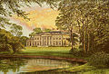
 Breamore House in the west of the county, north of the New Forest (from Portal:Hampshire/Selected pictures)
 -

-

-
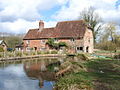 The mill at Greywell in the north-east of Hampshire (from Portal:Hampshire/Selected pictures)
 -
 The seafront and beach at Lee-on-the-Solent (from Portal:Hampshire/Selected pictures)
 -
-
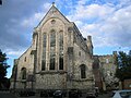 The West window of Romsey Abbey (from Portal:Hampshire/Selected pictures)
 -

-
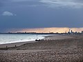
 Winter sunshine at Keyhaven (from Portal:Hampshire/Selected pictures)
 -
The seafront and beach at Lee-on-the-Solent (from Portal:Hampshire/Selected pictures)
-
 A boat on the Basingstoke Canal (from Portal:Hampshire/Selected pictures)
 -

-
-

-
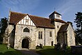 The church at Breamore in the west of the county, north of the New Forest (from Portal:Hampshire/Selected pictures)
 -
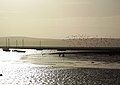
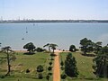
 Hayling Island's mainly shingle beach with Portsmouth's Spinnaker Tower beyond (from Portal:Hampshire/Selected pictures)
 -
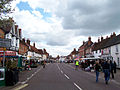
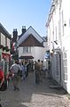
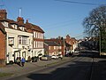 View looking east along West Street, New Alresford (from Portal:Hampshire/Selected pictures)
 -
 The Rose Bowl, near Southampton, home to Hampshire County Cricket Club (from Portal:Hampshire/Selected pictures)
 -
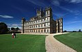 Highclere Castle in the far north of Hampshire, a large country house in the Jacobethan style by the architect Charles Barry, with a large park designed by Capability Brown, used as the set for Downton Abbey. (from Portal:Hampshire/Selected pictures)
 -
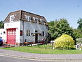 West End Fire Station, near Southampton, designed by Herbert Collins (from Portal:Hampshire/Selected pictures)
 -
 Fawley Oil Refinery from the remains of Netley Hospital in the Royal Victoria Country Park (from Portal:Hampshire/Selected pictures)
 -
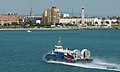 Hovercraft passing the mixed architecture, public gardens and shingle beach at Southsea, Portsmouth (from Portal:Hampshire/Selected pictures)
 -
 Trees on Southampton Common in winter (from Portal:Hampshire/Selected pictures)
 -
 Heathland in the New Forest (from Portal:Hampshire/Selected pictures)
 -
 Odiham High Street in the north-east of Hampshire (from Portal:Hampshire/Selected pictures)
 -
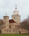
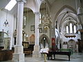 The interior of Portsmouth Cathedral (from Portal:Hampshire/Selected pictures)
 -
 Twyford Post Office and stores, between Winchester and Southampton (from Portal:Hampshire/Selected pictures)
 -
-
-


Apr2006.jpg)


Selected biography

Plegmund (or Plegemund; died 2 August either 914 or 923) was a medieval English Archbishop of Canterbury. He may have been a hermit before he became archbishop in 890. As archbishop, he reorganised the Diocese of Winchester, creating four new sees, and worked with other scholars in translating religious works. He was canonised after his death. (Full article...)
Did you know
- ... that Walkelin, Bishop of Winchester, began the construction of the modern Winchester Cathedral in 1079?
- ... that James Tissot is thought to have transgressed many Victorian sexual boundaries in his work, even setting a painting aboard the HMS Calcutta as a pun on a female subject's behind?
- ... that Winchester United Church, a place of worship in the City of Winchester District, Hampshire, was built into the walls of the former county jail?
- ... that Commander Samuel Sparshott, who testified at Lord Gambier's court-martial, and Admiral Edward Sparshott, who commanded the 52-gun HMS Winchester, were brothers who served in the Napoleonic Wars?
- ... that Winchester College football used to be played on top of a hill, with a line of boys on each side to keep the ball from rolling away?
- ... that the Theatre Royal, Southampton, which Jane Austen visited in 1807, was described in 2013 as having "morphed into a hideous high-rise"?
Related portals
Subcategories
Topics
More articles: Business in Hampshire | Geology of Hampshire | History of Hampshire | Portsmouth | Recreational walks in Hampshire | Southampton | Winchester
Lists: List of churches in Hampshire | List of further education colleges in Hampshire | List of Parliamentary constituencies in Hampshire | List of places in Hampshire
Recognised content
| This is a list of recognized content, updated weekly by JL-Bot (talk · contribs) (typically on Saturdays). There is no need to edit the list yourself. If an article is missing from the list, make sure it is tagged (e.g. {{WikiProject Hampshire}}) or categorized correctly and wait for the next update. See WP:RECOG for configuration options. |
Featured articles
 Ælfheah of Canterbury
- Bramshill House
- Southampton Cenotaph
- Chandler's Ford shooting
- Droxford railway station
- Ecgberht, King of Wessex
- Frank Jenner
- John Leak
- Mary Rose
- Netley Abbey
- New Forest pony
- Portsmouth War Memorial
- Robert Roberts (writer)
- Tichborne case
- HMS Warrior (1860)
- The World Before the Flood
- Murder of Joanna Yeates
Featured lists
Good articles
 A303 road
- All Saints' Church, Southampton
- Battle of Alton
- Andover F.C.
- Architecture of Winchester College
- Jane Austen
- Bentworth
- Henry Biard
- Binsted
- Bournemouth
- Bradley, Hampshire
- Calshot Castle
- Christchurch, Dorset
- Danebury
- Murder of Teresa De Simone
- Tom Denning, Baron Denning
- East Worldham
- 1900 FA Cup final
- 1902 FA Cup final
- 1952 Farnborough Airshow crash
- Murder of Céline Figard
- Charles Fryatt
- Germanus of Winchester
- Jack Hobbs (footballer)
- Hurst Castle
- Itchen Navigation
- Medieval Merchant's House
- Medstead
- Netley Castle
- Notions (Winchester College)
- Oakhanger, Hampshire
- Plegmund
- Portsmouth
- Queen Mary 2
- River Rother, West Sussex
- SeaCity Museum
- Shalden
- South Stoneham House
- Southampton Castle
- Southampton town walls
- St Andrew's Castle, Hamble
- St Catherine's Hill, Hampshire
- Steep, Hampshire
- Twyford Down
- Peter Vincenti
- West Worldham
- Winchester College
- Winchester College football
- Winslade
WikiProjects
Things you can do
Nominate for selection:
Expand: Abbots Worthy | Cadnam | Chartwell Green | List of churches in Hampshire | Deane, Hampshire | East Hampshire | Farnborough Airfield | Geography of Gosport | Micheldever | Monks Brook | More...
Create: Baddesley Manor | Chilworth Manor (currently a redirect) | Gosport and Fareham Omnibus Company
Find references for: Accord of Winchester | Aldershot | Alton, Hampshire | Alverstoke | Andover, Hampshire | Arthur Wellesley, 1st Duke of Wellington | Bedales School | Bitterne Park School | Boyatt Wood | Brenda Rawnsley | Brian Murphy (actor) | Brockenhurst | C. B. Fry | Calleva Atrebatum | Cantell Secondary School
Associated Wikimedia
The following Wikimedia Foundation sister projects provide more on this subject:
-
 Commons
Free media repository -
 Wikibooks
Free textbooks and manuals -
 Wikidata
Free knowledge base -
 Wikinews
Free-content news -
 Wikiquote
Collection of quotations -
 Wikisource
Free-content library -
 Wikiversity
Free learning tools -
 Wikivoyage
Free travel guide -
 Wiktionary
Dictionary and thesaurus


