L'Échelle-Saint-Aurin is a commune in the Somme department in Hauts-de-France in northern France.
L'Échelle-Saint-Aurin | |
|---|---|
_France_(2).JPG) Town hall | |
Location of L'Échelle-Saint-Aurin  | |
 L'Échelle-Saint-Aurin  L'Échelle-Saint-Aurin | |
| Coordinates: 49°41′44″N 2°42′43″E / 49.6956°N 2.7119°E | |
| Country | France |
| Region | Hauts-de-France |
| Department | Somme |
| Arrondissement | Montdidier |
| Canton | Roye |
| Intercommunality | Grand Roye |
| Government | |
| • Mayor (2020–2026) | Jean-Marie Carré[1] |
| Area 1 | 5.1 km2 (2.0 sq mi) |
| Population (2021)[2] | 47 |
| • Density | 9.2/km2 (24/sq mi) |
| Time zone | UTC+01:00 (CET) |
| • Summer (DST) | UTC+02:00 (CEST) |
| INSEE/Postal code | 80263 /80700 |
| Elevation | 61–97 m (200–318 ft) (avg. 64 m or 210 ft) |
| 1 French Land Register data, which excludes lakes, ponds, glaciers > 1 km2 (0.386 sq mi or 247 acres) and river estuaries. | |
Geography edit
The commune is situated 32 kilometres (20 mi) southeast of Amiens on the D54, and on the banks of the Avre, 3 kilometres (2 mi) from the A1 autoroute.
Population edit
| Year | Pop. | ±% p.a. |
|---|---|---|
| 1968 | 71 | — |
| 1975 | 72 | +0.20% |
| 1982 | 74 | +0.39% |
| 1990 | 62 | −2.19% |
| 1999 | 50 | −2.36% |
| 2007 | 55 | +1.20% |
| 2012 | 56 | +0.36% |
| 2017 | 53 | −1.10% |
| Source: INSEE[3] | ||
-
 St Peter church
 -
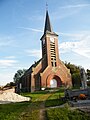
 St Aurin church
_France_(3).JPG)
_France_(2).JPG)
See also edit
References edit
- ^ "Répertoire national des élus: les maires". data.gouv.fr, Plateforme ouverte des données publiques françaises (in French). 2 December 2020.
- ^ "Populations légales 2021". The National Institute of Statistics and Economic Studies. 28 December 2023.
- ^ Population en historique depuis 1968, INSEE
Wikimedia Commons has media related to L'Échelle-Saint-Aurin.