The World Portal


The world is the totality of entities, the whole of reality, or everything that exists. The nature of the world has been conceptualized differently in different fields. Some conceptions see the world as unique while others talk of a "plurality of worlds". Some treat the world as one simple object while others analyze the world as a complex made up of parts.
In scientific cosmology, the world or universe is commonly defined as "[t]he totality of all space and time; all that is, has been, and will be". Theories of modality talk of possible worlds as complete and consistent ways how things could have been. Phenomenology, starting from the horizon of co-given objects present in the periphery of every experience, defines the world as the biggest horizon or the "horizon of all horizons". In philosophy of mind, the world is contrasted with the mind as that which is represented by the mind. Theology conceptualizes the world in relation to God, for example, as God's creation, as identical to God or as the two being interdependent. In religions, there is a tendency to downgrade the material or sensory world in favor of a spiritual world to be sought through religious practice. A comprehensive representation of the world and our place in it, as is found in religions, is known as a worldview. Cosmogony is the field that studies the origin or creation of the world while eschatology refers to the science or doctrine of the last things or of the end of the world.
In various contexts, the term "world" takes a more restricted meaning associated, for example, with the Earth and all life on it, with humanity as a whole or with an international or intercontinental scope. In this sense, world history refers to the history of humanity as a whole and world politics is the discipline of political science studying issues that transcend nations and continents. Other examples include terms such as "world religion", "world language", "world government", "world war", "world population", "world economy", or "world championship". (Full article...)
Selected articles -
-


Temperature record of the last 2,000 years (Chart showing the so-called Medieval Warm Period and Little Ice Age were not planet-wide phenomena)
The global temperature record shows the fluctuations of the temperature of the atmosphere and the oceans through various spans of time. There are numerous estimates of temperatures since the end of the Pleistocene glaciation, particularly during the current Holocene epoch. Some temperature information is available through geologic evidence, going back millions of years. More recently, information from ice cores covers the period from 800,000 years before the present time until now. A study of the paleoclimate covers the time period from 12,000 years ago to the present. Tree rings and measurements from ice cores can give evidence about the global temperature from 1,000-2,000 years before the present until now. The most detailed information exists since 1850, when methodical thermometer-based records began. Modifications on the Stevenson-type screen were made for uniform instrument measurements around 1880. (Full article...) -

The Space Race was a 20th-century competition between two Cold War rivals, the United States and the Soviet Union, to achieve superior spaceflight capability. It had its origins in the ballistic missile-based nuclear arms race between the two nations following World War II and had its peak with the more particular Moon Race to land on the Moon between the US moonshot and Soviet moonshot programs. The technological advantage demonstrated by spaceflight achievement was seen as necessary for national security and became part of the symbolism and ideology of the time. The Space Race brought pioneering launches of artificial satellites, robotic space probes to the Moon, Venus, and Mars, and human spaceflight in low Earth orbit and ultimately to the Moon.
Public interest in space travel originated in the 1951 publication of a Soviet youth magazine and was promptly picked up by US magazines. The competition began on July 30, 1955, when the United States announced its intent to launch artificial satellites for the International Geophysical Year. Four days later, the Soviet Union responded by declaring they would also launch a satellite "in the near future". The launching of satellites was enabled by developments in ballistic missile capabilities since the end of World War II. The competition gained Western public attention with the "Sputnik crisis", when the USSR achieved the first successful satellite launch, Sputnik 1, on October 4, 1957. It gained momentum when the USSR sent the first human, Yuri Gagarin, into space with the orbital flight of Vostok 1 on April 12, 1961. These were followed by a string of other early firsts achieved by the Soviets over the next few years. (Full article...) -

The Egyptian–Hittite peace treaty, on display at the Istanbul Archaeology Museum, is believed to be the earliest example of any written international agreement of any kind.
A treaty is a formal, legally binding written contract between actors in international law. It is usually made by and between sovereign states, but can include international organizations, individuals, business entities, and other legal persons.
A treaty may also be known as an international agreement, protocol, covenant, convention, pact, or exchange of letters, among other terms. However, only documents that are legally binding on the parties are considered treaties under international law. Treaties vary in their obligations (the extent to which states are bound to the rules), precision (the extent to which the rules are unambiguous), and delegation (the extent to which third parties have authority to interpret, apply and make rules). (Full article...) -

Second preliminary session of the World Summit Information Society, plenary meeting, 18–25 February 2005, UN building, Geneva, Switzerland.
The World Summit on the Information Society (WSIS) was a two-phase United Nations-sponsored summit on information, communication and, in broad terms, the information society that took place in 2003 in Geneva and in 2005 in Tunis. WSIS Forums have taken place periodically since then. One of the Summit's chief aims is to bridge the global digital divide separating rich countries from poor countries by increasing internet accessibility in the developing world. The conferences established 17 May as World Information Society Day.
The WSIS+10 Process marked the ten-year milestone since the 2005 Summit. In 2015, the stocktaking process culminated with a High-Level meeting of the UN General Assembly on 15 and 16 December in New York. (Full article...) -
Three European Union schemes of geographical indications and traditional specialties, known as protected designation of origin (PDO), protected geographical indication (PGI), and traditional speciality guaranteed (TSG), promote and protect names of agricultural products and foodstuffs. Products registered under one of the three schemes may be marked with the logo for that scheme to help identify those products. The schemes are based on the legal framework provided by the EU Regulation No 1151/2012 of the European Parliament and of the Council of 21 November 2012 on quality schemes for agricultural products and foodstuffs. This regulation applies within the EU as well as in Northern Ireland. Protection of the registered products is gradually expanded internationally via bilateral agreements between the EU and non-EU countries. It ensures that only products genuinely originating in that region are allowed to be identified as such in commerce. The legislation first came into force in 1992. The purpose of the law is to protect the reputation of the regional foods, promote rural and agricultural activity, help producers obtain a premium price for their authentic products, and eliminate the unfair competition and misleading of consumers by non-genuine products, which may be of inferior quality or of different flavour. Critics argue that many of the names, sought for protection by the EU, have become commonplace in trade and should not be protected.
These regulations protect the names of wines, cheeses, hams, sausages, seafood, olives, olive oils, beers, balsamic vinegar, regional breads, fruits, raw meats and vegetables. (Full article...) -

The primary causes and the wide-ranging impacts of climate change. Some effects act as positive feedbacks that amplify climate change.
Effects of climate change are well documented and growing for Earth's natural environment and human societies. Changes to the climate system include an overall warming trend, changes to precipitation patterns, and more extreme weather. As the climate changes it impacts the natural environment with effects such as more intense forest fires, thawing permafrost, and desertification. These changes impact ecosystems and societies, and can become irreversible once tipping points are crossed.
The effects of climate change vary in timing and location. Up until now the Arctic has warmed faster than most other regions due to climate change feedbacks. Surface air temperatures over land have also increased at about twice the rate they do over the ocean, causing intense heat waves. These temperatures would stabilize if greenhouse gas emissions were brought under control. Ice sheets and oceans absorb the vast majority of excess heat in the atmosphere, delaying effects there but causing them to accelerate and then continue after surface temperatures stabilize. Sea level rise is a particular long term concern as a result. The effects of ocean warming also include marine heatwaves, ocean stratification, deoxygenation, and changes to ocean currents. The ocean is also acidifying as it absorbs carbon dioxide from the atmosphere. (Full article...) -
A megacity is a very large city, typically with a population of more than 10 million people. The United Nations Department of Economic and Social Affairs in its 2018 "World Urbanization Prospects" report defines megacities as urban agglomerations with over 10 million inhabitants. A University of Bonn report holds that they are "usually defined as metropolitan areas with a total population of 10 million or more people". Elsewhere in other sources, from five to eight million is considered the minimum threshold, alongside a population density of at least 2,000 per square kilometre. The terms conurbation, metropolis, and metroplex are also applied to the latter.
The total number of megacities in the world varies between different sources: The world had 33 according to the UN (in 2018), 45 according to CityPopulation.de (in 2023), and 44 according to Demographia (in 2023). About half of these urban agglomerations are in China and India. The other four countries with more than one megacity are Brazil, Japan, Pakistan, and the United States. African megacities are present in Nigeria, Egypt, South Africa, and the DRC; European megacities are present in Russia, France, the United Kingdom, and Turkey (also in Asia); megacities can be found in Latin America in the countries of Brazil, Mexico, Colombia, Peru, and Argentina. Some sources identify Tokyo's Greater Tokyo Area as the largest megacity in the world, while some others give the title to the Pearl River Delta in China. (Full article...)


General images -
-
 A pillar at Göbekli Tepe
 -
 The pale orange dot, an artist's impression of the early Earth which might have appeared orange through its hazy methane rich prebiotic second atmosphere. Earth's atmosphere at this stage was somewhat comparable to today's atmosphere of Titan. (from History of Earth)
 -
 Obelisk of Axum, Ethiopia
 -
 Change in average surface air temperature and drivers for that change. Human activity has caused increased temperatures, with natural forces adding some variability. (from Earth)
 -
 Ajloun Castle, Jordan
 -
 Yggdrasil, an attempt to reconstruct the Norse world tree which connects the heavens, the world, and the underworld. (from World)
 -
 Cross-section through a liposome (from History of Earth)
 -

-
 Vitruvian Man by Leonardo da Vinci epitomizes the advances in art and science seen during the Renaissance. (from History of Earth)
 -
 Great Pyramids of Giza, Egypt
 -
 "Lucy", the first Australopithecus afarensis skeleton found. Lucy was only 1.06 m (3 ft 6 in) tall.
 -
 Earth's history with time-spans of the eons to scale (from History of Earth)
 -

-
 Geologic map of North America, color-coded by age. From most recent to oldest, age is indicated by yellow, green, blue, and red. The reds and pinks indicate rock from the Archean.
 -
 Earth's land use for human agriculture in 2019 (from Earth)
 -
 Olmec colossal head, now at the Museo de Antropología de Xalapa
 -
 Earth's night-side upper atmosphere appearing from the bottom as bands of afterglow illuminating the troposphere in orange with silhouettes of clouds, and the stratosphere in white and blue. Next the mesosphere (pink area) extends to the orange and faintly green line of the lowest airglow, at about one hundred kilometers at the edge of space and the lower edge of the thermosphere (invisible). Continuing with green and red bands of aurorae stretching over several hundred kilometers. (from Earth)
 -
 A schematic view of Earth's magnetosphere with solar wind flowing from left to right (from Earth)
 -
 Artist's impression of the enormous collision that probably formed the Moon (from History of Earth)
 -
 A banded iron formation from the 3.15 Ga Moodies Group, Barberton Greenstone Belt, South Africa. Red layers represent the times when oxygen was available; gray layers were formed in anoxic circumstances. (from History of Earth)
 -
 View of Earth from the Moon by the Lunar Reconnaissance Orbiter (from Earth)
 -

-
Pale orange dot, an artist's impression of Early Earth, featuring its tinted orange methane-rich early atmosphere (from Earth)
-
 Angkor Wat temple complex, Cambodia, early 12th century
 -

-

-
 An artist's impression of the Archean, the eon after Earth's formation, featuring round stromatolites, which are early oxygen-producing forms of life from billions of years ago. After the Late Heavy Bombardment, Earth's crust had cooled, its water-rich barren surface is marked by continents and volcanoes, with the Moon still orbiting Earth half as far as it is today, appearing 2.8 times larger and producing strong tides. (from Earth)
 -
 A reconstruction of Pannotia (550 Ma). (from History of Earth)
 -
 Tracy Caldwell Dyson, a NASA astronaut, observing Earth from the Cupola module at the International Space Station on 11 September 2010 (from Earth)
 -

-
 The replicator in virtually all known life is deoxyribonucleic acid. DNA is far more complex than the original replicator and its replication systems are highly elaborate. (from History of Earth)
 -

-
 Taj Mahal, Mughal Empire, India
 -
 First airplane, the Wright Flyer, flew on 17 December 1903.
 -
 An artist's impression of ice age Earth at glacial maximum. (from History of Earth)
 -
 Battle during 1281 Mongol invasion of Japan
 -

-

-

-
 A view of Earth with different layers of its atmosphere visible: the troposphere with its clouds casting shadows, a band of stratospheric blue sky at the horizon, and a line of green airglow of the lower thermosphere around an altitude of 100 km, at the edge of space (from Earth)
 -
 An animation of the changing density of productive vegetation on land (low in brown; heavy in dark green) and phytoplankton at the ocean surface (low in purple; high in yellow) (from Earth)
 -
 Chloroplasts in the cells of a moss (from History of Earth)
 -
 An artist's rendering of a protoplanetary disk (from History of Earth)
 -

-
 A reconstruction of human history based on fossil data. (from History of Earth)
 -
 Great Mosque of Kairouan, Tunisia, founded 670 CE
 -
 A 580 million year old fossil of Spriggina floundensi, an animal from the Ediacaran period. Such life forms could have been ancestors to the many new forms that originated in the Cambrian Explosion. (from History of Earth)
 -
 Persepolis, Achaemenid Empire, 6th century BCE
 -

-
 Earth's axial tilt causing different angles of seasonal illumination at different orbital positions around the Sun (from Earth)
 -

-
 A computer-generated image mapping the prevalence of artificial satellites and space debris around Earth in geosynchronous and low Earth orbit (from Earth)
 -
 Japanese depiction of a Portuguese carrack. European maritime innovations led to proto-globalization.
 -
 Trilobites first appeared during the Cambrian period and were among the most widespread and diverse groups of Paleozoic organisms. (from History of Earth)
 -
 Artist's conception of Devonian flora (from History of Earth)
 -
 Image of the physical world, captured by the Hubble Space Telescope (from World)
 -
 Earth's western hemisphere showing topography relative to Earth's center instead of to mean sea level, as in common topographic maps (from Earth)
 -
 Map of peopling of the world (Southern Dispersal paradigm), in thousands of years ago.
 -
 Ming dynasty section, Great Wall of China
 -

-
 Standing Buddha from Gandhara, 2nd century CE
 -
 Empires of the world in 1898
 -
 Artist's conception of Hadean Eon Earth, when it was much hotter and inhospitable to all forms of life. (from History of Earth)
 -
 A composite image of artificial light emissions at night on a map of Earth (from Earth)
 -
 The Pantheon, originally a Roman temple, now a Catholic church
 -

-
 Artist's rendition of an oxinated fully-frozen Snowball Earth with no remaining liquid surface water. (from History of Earth)
 -
 A 2012 artistic impression of the early Solar System's protoplanetary disk from which Earth and other Solar System bodies were formed (from Earth)
 -
 A Benin Bronze head from Nigeria
 -
 Shanghai. China urbanized rapidly in the 21st century.
 -

-
 Satellite time lapse imagery of Earth's rotation showing axis tilt (from Earth)
 -
 A composite image of Earth, with its different types of surface discernible: Earth's surface dominating Ocean (blue), Africa with lush (green) to dry (brown) land and Earth's polar ice in the form of Antarctic sea ice (grey) covering the Antarctic or Southern Ocean and the Antarctic ice sheet (white) covering Antarctica. (from Earth)
 -

-
 Notre-Dame de Paris, France
 -
 Dinosaurs were the dominant terrestrial vertebrates throughout most of the Mesozoic (from History of Earth)
 -
 Artist's impression of a Hadean landscape with the relatively newly formed Moon still looming closely over Earth and both bodies sustaining strong volcanism. (from History of Earth)
 -
 Graph showing range of estimated partial pressure of atmospheric oxygen through geologic time (from History of Earth)
 -
 Pangaea was a supercontinent that existed from about 300 to 180 Ma. The outlines of the modern continents and other landmasses are indicated on this map. (from History of Earth)
 -

-
 Machu Picchu, Inca Empire, Peru
 -
 Tiktaalik, a fish with limb-like fins and a predecessor of tetrapods. Reconstruction from fossils about 375 million years old. (from History of Earth)
 -
 A view of Earth with its global ocean and cloud cover, which dominate Earth's surface and hydrosphere; at Earth's polar regions, its hydrosphere forms larger areas of ice cover. (from Earth)
 -
 Last Moon landing: Apollo 17 (1972)
 -
 Fall of the Berlin Wall, 1989
 -
 Lithified stromatolites on the shores of Lake Thetis, Western Australia. Archean stromatolites are the first direct fossil traces of life on Earth. (from History of Earth)
 -
 Florence, birthplace of the Italian Renaissance
 -
Artist's impression of Earth during the later Archean, the largely cooled planetary crust and water-rich barren surface, marked by volcanoes and continents, features already round microbialites. The Moon, still orbiting Earth much closer than today and still dominating Earth's sky, produced strong tides. (from History of Earth)
-

-

-
 A map of heat flow from Earth's interior to the surface of Earth's crust, mostly along the oceanic ridges (from Earth)
 -
 Chennakesava Temple, Belur, India


.jpg)


.svg)


.jpg)


.jpeg)

.jpg)


Megacities of the world -
.jpeg)
London is the capital and largest city of both England and the United Kingdom, with a population of around 8.8 million, and its metropolitan area is the largest in Western Europe, with a population of 14.9 million. It stands on the River Thames in south-east England at the head of a 50-mile (80 km) estuary down to the North Sea and has been a major settlement for nearly two millennia. The City of London, its ancient core and financial centre, was founded by the Romans as Londinium and retains its medieval boundaries. The City of Westminster, to the west of the City of London, has for centuries hosted the national government and parliament. In the 19th century, London grew rapidly, becoming the world's largest city at the time, as it expanded and absorbed the surrounding county of Middlesex, and parts of Surrey and Kent. In 1965 it was combined with parts of Essex and Hertfordshire to create the administrative area of Greater London, which is governed by 33 local authorities and the Greater London Authority.
As one of the world's major global cities, London exerts a strong influence on world art, entertainment, fashion, commerce and finance, education, health care, media, science and technology, tourism, transport, and communications. Despite a post-Brexit exodus of stock listings from the London Stock Exchange, London is still Europe's most economically powerful city, and it remains one of the major financial centres in the world. With Europe's largest concentration of higher education institutions, it is home to some of the highest-ranked academic institutions in the world—Imperial College London in natural and applied sciences, the London School of Economics in social sciences, and the comprehensive University College London. London is the most visited city in Europe and has the busiest city airport system in the world. The London Underground is the oldest rapid transit system in the world. (Full article...)Did you know -

- ... that chef Lata Tondon once set a Guinness World Record with a cooking marathon lasting 87 hours 45 minutes?
- ... that before Emine Arslan became a world kickboxing champion she smoked two packets of cigarettes a day?
- ... that in the 1916 Declaration of Sainte-Adresse Britain, France and Russia committed to securing the political and economic independence of Belgium after the First World War?
- ... that Christian Krohg's painting Leiv Eirikson Discovering America was shown at the 1893 World's Columbian Exposition together with a replica of a Viking ship?
- ... that William D. Leahy was the highest-ranking American military officer in World War II?
- ... that 120 years after the founding of the world's first homosexual organization in 1897, a monument near its former headquarters was unveiled in Berlin?
- ... that the exhibition Heaven on Earth: Art from Islamic Lands included art from the 8th to 19th centuries?
- ... that the Brazilian cruiser Almirante Barroso was on a voyage to circumnavigate Earth with Prince August Leopold on board when the republic was proclaimed in Brazil?
Countries of the world -

Andorra, officially the Principality of Andorra, is a sovereign landlocked country on the Iberian Peninsula, in the eastern Pyrenees, bordered by France to the north and Spain to the south. Believed to have been created by Charlemagne, Andorra was ruled by the count of Urgell until 988, when it was transferred to the Roman Catholic Diocese of Urgell. The present principality was formed by a charter in 1278. It is currently headed by two co-princes: the bishop of Urgell in Spain and the president of France. Its capital and largest city is Andorra la Vella.
Andorra is the sixth-smallest state in Europe, with an area of 468 square kilometres (181 sq mi) and a population of approximately 79,034.0 The Andorran people are a Romance ethnic group closely related to Catalans. Andorra is the world's 16th-smallest country by land and 11th-smallest by population. Its capital, Andorra la Vella, is the highest capital city in Europe, at an elevation of 1,023 metres (3,356 feet) above sea level. The official language is Catalan, but Spanish, Portuguese, and French are also commonly spoken. (Full article...)
Various lists of the Wonders of the World have been compiled from antiquity to the present day, in order to catalogue the world's most spectacular natural features and human-built structures.The Seven Wonders of the Ancient World is the oldest known list of this type, documenting the most remarkable human-made creations of classical antiquity; it was based on guidebooks popular among Hellenic sightseers and as such only includes works located around the Mediterranean rim and in the ancient Near East. The number seven was chosen because the Greeks believed it represented perfection and plenty, and because it reflected the number of planets known in ancient times (five) plus the Sun and Moon. (Full article...)
Related portals
Protected areas of the world -
-
-

In the Philippines, Protected Areas are administered by the Department of Environment and Natural Resources (DENR)'s Biodiversity Management Bureau under the National Integrated Protected Areas System (NIPAS) Act of 1992. As of 2020, there are 244 Protected Areas in the Philippines covering a total area of about 7,760,000 hectares (19,200,000 acres) – 15.4% of the Philippines' total area. (Full article...) -
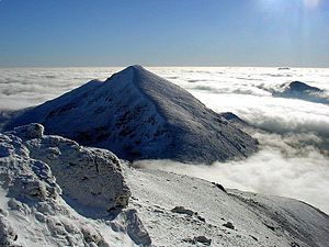
The mountain of Stob Binnein lies in the Loch Lomond and The Trossachs National Park.
Many parts of Scotland are protected in accordance with a number of national and international designations because of their environmental, historical or cultural value. Protected areas can be divided according to the type of resource which each seeks to protect. NatureScot has various roles in the delivery of many environmental designations in Scotland, i.e. those aimed at protecting flora and fauna, scenic qualities and geological features. Historic Environment Scotland is responsible for designations that protect sites of historic and cultural importance. Some international designations, such as World Heritage Sites, can cover both categories of site.
The various designations overlap considerably with many protected areas being covered by multiple designations with different boundaries. (Full article...) -
-
Protected areas of Norway include:
About 17 percent of the mainland of Norway is protected. Of this, ca. 8.3 percent is national parks, 1.3 percent is nature reserves and 4.7 percent otherwise protected. (Full article...) -

Mombacho Volcano Natural Reserve
The protected areas of Nicaragua are areas that have natural beauty or significance and are protected by Nicaragua. Nicaragua has 78 protected areas that cover 22,422 km2, about 17.3% of the nations landmass. The National System of Protected Areas (SINAP) is administered by the Ministry of the Environment and Natural Resources (MARENA). (Full article...) -
The Protected areas of New South Wales include both terrestrial and marine protected areas. there are 225 national parks in New South Wales. A number established since the late 1970s followed campaigns by local residents and environmentalists.
Based on the Collaborative Australian Protected Area Database (CAPAD) 2020 data there are 2136 separate terrestrial protected areas with a total land area of 7,696,641 hectares (19,018,810 acres) (9.61% of the state's area). CAPAD data also shows 18 marine protected areas with a total area of 348,849 hectares (862,020 acres), covering 39.63% of NSW waters. (Full article...) -
Protected areas of Ukraine (Ukrainian: охоронні території) are special areas of Ukraine established with the goal of protecting the natural and cultural heritage of the country from excessive changes as a result of human activity. The protection of the areas is the responsibility of the government of Ukraine, specifically the Cabinet of Ministers of Ukraine.
Ukraine has several categories of protected areas of Ukraine and the protected areas include: (Full article...) -
Bihar is a state in East India. It is bounded by Uttar Pradesh to the west, Nepal to the north, West Bengal to the east and Jharkhand to the south. About 7% of the state is protected forest area. (Full article...)
-
This is a list of protected areas of Saudi Arabia, some of which are managed by the Saudi Wildlife Authority.:
- At-Taysiyah Protected Area
- Jabal Shada Nature Reserve
- Majami'al-Hadb Protected Area
- Nafud al-'Urayq
- Raydah Natural Reserve
- 'Uruq Bani Ma'arid
- Saja Umm Ar-Rimth Natural Reserve
- Harrat al-Harrah Protected Area
- Al-Khunfah Natural Reserve
- Ibex Reserve Protected Area
- Mahazat as-Sayd Protected Area
- Umm al-Qamari Islands
- Al-Tubayq Natural Reserve
- Farasan Islands Protected Area
- Jubail Marine Wildlife Sanctuary
- Jabal Aja Protected Area
- Wadi Turabah Nature Reserve
-
Desert landscape in Qatar
Protected areas of Qatar include:- Al Reem Biosphere Preserve (designated in 2007) is part of the World Network of Biosphere Reserves in the Arab States
- Al Shahaniyah Park in Al-Shahaniya
- Al Thakira Nature Reserve in Al Thakhira
- Al Wabra Wildlife Preservation
- Dahl Al Hammam Park, a sinkhole in Doha (entrance to the hole is now closed to the public)
- Khor Al Adaid Natural Reserve in Khor Al Adaid
- Khor Al Udeid Fish Sanctuary
- Mudhlem Cave in Mukaynis
- Musfer Sinkhole in Salwa
- Ras Abrouq Nature Reserve (also known as Bir Zekreet (Zekreet Beach)) in Ras Abrouq
- Ras Ushairij Gazelle Conservation Park
- Umm Tais National Park
-
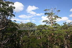
The Valley of the Giants skywalk at Walpole-Nornalup National Park
Western Australia is the second largest country subdivision in the world.
As of 2022, based on the latest Collaborative Australian Protected Areas Database report, it contains 1857 separate land-based protected areas with a total area of 76,142,710 hectares (188,152,700 acres), accounting for just over 30 percent of the state's land mass. By area, Indigenous Protected Areas account for the largest part of this, almost 67 percent while, by number, nature reserves hold the majority with two-third of all land-based protected areas being nature reserves. (Full article...) -
The state of Johor in Malaysia is noted for its national parks and forest reserves which preserve virgin rainforests known for its biodiversity and endangered species of animals.
Mangrove swamps and coral reefs are also protected within these parks. (Full article...) -
Greece is characterized by an extremely fragmented, rugged landscape hosting a great diversity of ecosystems and an outstanding biodiversity. Almost 5% of its extensive coastline consists of ecologically sensitive wetlands. Two thirds of the total population live no further than 2 km from the coast and most of the important urban centers are coastal, while almost all of the tourist infrastructure is divided among islands and the coastal mainland. (Full article...)
-
Protected areas of Libya include any geographical area protected for a specific use.
Most protected areas are intended for the conservation of flora and fauna. Libya's national parks and nature reserves are maintained by the "Technical Committee of Wildlife and National Parks" which was created in 1990, as part of the General Secretariat of Agricultural Reclamation and Land Reform. (Full article...)


.jpg)

Selected world maps
-
 The world map by Gerardus Mercator (1569), the first map in the well-known Mercator projection
 -
 Mollweide projection of the world
 -
 The Goode homolosine projection is a pseudocylindrical, equal-area, composite map projection used for world maps.
 -
 Time zones of the world
 -
 Index map from the International Map of the World (1:1,000,000 scale)
 -
 United Nations Human Development Index map by country (2016)
 -
 1516 map of the world by Martin Waldseemüller
 -
 A plate tectonics map with volcano locations indicated with red circles
 -
 Only a few of the largest large igneous provinces appear (coloured dark purple) on this geological map, which depicts crustal geologic provinces as seen in seismic refraction data


World records
- List of Olympic records in athletics
- List of world records in athletics
- List of junior world records in athletics
- List of world records in masters athletics
- List of world youth bests in athletics
- List of IPC world records in athletics
- List of world records in canoeing
- List of world records in chess
- List of cycling records
- List of world records in track cycling
- List of world records in finswimming
- List of world records in juggling
- List of world records in rowing
- List of world records in speed skating
- List of world records in swimming
- List of IPC world records in swimming
- List of world records in Olympic weightlifting
Topics

Continents of Earth | ||||||||
|---|---|---|---|---|---|---|---|---|
| ||||||||
| ||||||||
| ||||||||


| Cenozoic Era (present–66.0 Ma) |
| ||||||||||||
|---|---|---|---|---|---|---|---|---|---|---|---|---|---|
| Mesozoic Era (66.0–252 Ma) |
| ||||||||||||
| Paleozoic Era (252–539 Ma) |
| ||||||||||||
| Proterozoic Eon (539 Ma–2.5 Ga) |
| ||||||||||||
| Archean Eon (2.5–4 Ga) | |||||||||||||
| Hadean Eon (4–4.6 Ga) | |||||||||||||
ka = kiloannum (thousands years ago); Ma = megaannum (millions years ago); Ga = gigaannum (billions years ago). See also: Geologic time scale • | |||||||||||||
| Locations | ||
|---|---|---|
| Related | ||

| |||||||||||||||||||
| |||||||||||||||||||
| |||||||||||||||||||

Economic classification of countries | |||||
|---|---|---|---|---|---|
| Three-World Model | |||||
| Gross domestic product (GDP) |
| ||||
| Gross national income (GNI) | |||||
| Wages | |||||
| Wealth | |||||
| Other national accounts | |||||
| Human development | |||||
| Digital divide | |||||
| Net international investment position (NIIP) | |||||
| Technological |
| ||||
|---|---|---|---|---|---|
| Sociological | |||||
| Ecological |
| ||||
| Biological |
| ||||
| Astronomical | |||||
| Eschatological |
| ||||
| Others |
| ||||
| Fictional | |||||
| Organizations | |||||
Categories

Wikimedia
The following Wikimedia Foundation sister projects provide more on this subject:
-
 Commons
Free media repository -
 Wikibooks
Free textbooks and manuals -
 Wikidata
Free knowledge base -
 Wikinews
Free-content news -
 Wikiquote
Collection of quotations -
 Wikisource
Free-content library -
 Wikispecies
Directory of species -
 Wikiversity
Free learning tools -
 Wikivoyage
Free travel guide -
 Wiktionary
Dictionary and thesaurus


