The Huadong Valley or Hualien–Taitung Valley (Chinese: 花東縱谷; pinyin: Huādōng Zònggǔ; Wade–Giles: Hua1-tung1 Tsung4-ku3), also known as East Rift Valley, the Longitudinal Valley or as the Nakasendō Plain (中仙道平野, Nakasendō Heiya) during the era of Japanese rule, is a long and narrow valley located between the Central Mountain Range and the Coastal Mountain Range of eastern Taiwan, stretching about 180 km (110 mi) from Hualien City at the north to Taitung City at the south..[1]
| Huadong Valley | |
|---|---|
 The Huadong Valley (in green) between the Central Mountain Range and the Coastal Mountain Range | |
| Length | 180 km (110 mi) |
| Geology | |
| Type | Valley |
| Geography | |
| Location | Taiwan |
| Coordinates | 23°26′24″N 121°21′43″E / 23.439959°N 121.362076°E |
The valley is believed to be part of the northern terminus of the Philippine Mobile Belt, a complex collection of tectonic plate fragments and volcanic intrusions. The valley is formed by the alluvial plains of three large river systems, namely the Hualien River, Xiuguluan River and Beinan River, all of which flow into the Pacific Ocean.
The Huadong Highway, a section of Provincial Highway No. 9, runs the entire length of the valley from north to south.
Gallery edit
-
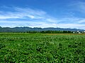 Huadong Valley, the Coastal Mountain Range can be seen in the distance
 -
 Rice paddy in Fengli, Shoufeng Township
 -
 Bicyclists on Highway 23 in Fuli Township
 -
 Decommissioned railway tracks by the Huadong Highway in Ruisui Township


See also edit
References edit
- ^ "East Rift Valley". RoundTAIWANRound. Retrieved 10 August 2018.
External links edit
This article about a location in Taiwan is a stub. You can help Wikipedia by expanding it. |