No higher resolution available.
Shebaafarms.png (288 × 344 pixels, file size: 236 KB, MIME type: image/png)
Summary edit
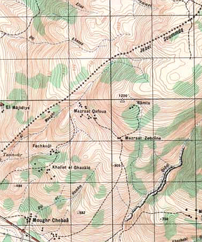
| Description | Detailed topographic map of the disputed Shebaa farms area. |
|---|---|
| Author or copyright owner |
|
| Source (WP:NFCC#4) | NI_36_XII_2c (Marjayoûn) sheet, provisional edition. Service Geographique de l'Armee du Liban, 1966. |
| Date of publication | 1966 |
| Use in article (WP:NFCC#7) | Shebaa farms |
| Purpose of use in article (WP:NFCC#8) | Refers to a dispute about the Syrian-Lebanese border (that is described in the article above), and to how it is reflected in maps. This map is one example of several Lebanese maps that reflect a view of the border's location that differs from the current official position of Lebanon. |
| Not replaceable with free media because (WP:NFCC#1) |
No free edition of this map or any other similar Lebanese maps is known to exist. |
| Minimal use (WP:NFCC#3) | Represents a small portion of the map (about 4.5%). Low resolution |
| Respect for commercial opportunities (WP:NFCC#2) |
|
| Fair useFair use of copyrighted material in the context of Shebaa farms//en.wikipedia.org/wiki/File:Shebaafarms.pngtrue | |
Licensing edit
 | This work is copyrighted (or assumed to be copyrighted) and unlicensed. It does not fall into one of the blanket acceptable non-free content categories listed at Wikipedia:Non-free content § Images or Wikipedia:Non-free content § Audio clips, and it is not covered by a more specific non-free content license listed at Category:Wikipedia non-free file copyright templates. However, it is believed that the use of this work:
qualifies as fair use under United States copyright law. Any other uses of this image, on Wikipedia or elsewhere, may be copyright infringement. See Wikipedia:Non-free content and Wikipedia:Copyrights. |
File history
Click on a date/time to view the file as it appeared at that time.
| Date/Time | Thumbnail | Dimensions | User | Comment | |
|---|---|---|---|---|---|
| current | 11:49, 11 October 2017 | | 288 × 344 (236 KB) | DatBot (talk | contribs) | Reduce size of non-free image (BOT - disable) |
| 09:09, 26 June 2005 | No thumbnail | 379 × 454 (404 KB) | Doron (talk | contribs) | Detailed topographic map of the disputed Shebaa Farms area. Service Geographique de l'Armee du Liban, 1966. {{Fairuseunsure}} |
You cannot overwrite this file.
File usage
The following pages on the English Wikipedia use this file (pages on other projects are not listed):