This article needs additional citations for verification. (July 2011) |
Waterloo is a settlement in South Australia, located just off the Barrier Highway between Manoora and Black Springs, approximately 121 kilometres (75 mi) north-east of the state capital of Adelaide.[5]
| Waterloo South Australia | |||||||||||||||
|---|---|---|---|---|---|---|---|---|---|---|---|---|---|---|---|
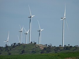
 The Waterloo windfarm looking southwest along the Tothill Range | |||||||||||||||
| Coordinates | 33°59′31″S 138°52′45″E / 33.992050°S 138.879240°E | ||||||||||||||
| Population | 82 (SAL 2016)[1][2] | ||||||||||||||
| Established | 1865 | ||||||||||||||
| Postcode(s) | 5413[3] | ||||||||||||||
| Location |
| ||||||||||||||
| LGA(s) | District Council of Clare and Gilbert Valleys | ||||||||||||||
| State electorate(s) | Frome, Goyder | ||||||||||||||
| Federal division(s) | Grey | ||||||||||||||
| |||||||||||||||
| Footnotes | Coordinates[4] | ||||||||||||||
History edit
The township of Waterloo was surveyed and established in 1865 in the Hundred of Waterloo, County of Light.[6] It derives its name from the famous battle of the Napoleonic Wars. Waterloo is situated in a valley on the head of the Light River. Located about midway between Kapunda and Burra, it is not to be confused with Waterloo Corner on the Adelaide Plains. In 1866 a petition was signed by 233 of the inhabitants and settlers for the establishment of a police station and courthouse.[7] The government rejected this, as the township then comprised not more than six houses, a flourmill, and a hotel.[8]
The locality is the birthplace of Tom Kruse, the Australian outback mailman who worked on the Birdsville Track in the border area between South Australia and Queensland.[9]
Land Use edit
Although the township of Waterloo never thrived, it became the service centre for a large rural community, providing such facilities as a school, churches, and shopping. Today it is in the midst of a productive agricultural district, which it continues to service. Windfarms have been established on nearby ranges.
Kunden (Carlsruhe) edit
Approximately two and half kilometres (1.5 miles) south of Waterloo is the locality of Kunden. Originally named Carlsruhe, it was established in the nineteenth century by German immigrants who built the Carlsruhe Lutheran church and an adjoining cemetery. In 1918 as part of the Act of Parliament to change German place names, Carlsruhe was renamed Kunden. Carlsruhe school had 44 students when it was closed in 1917 as a consequence of law changes that required students to be taught in English rather than German.[10] Today, the locality is now part of the greater Waterloo postcode area and all that remains of its original namesake is the church, cemetery and Carlsruhe Road.
References edit
- ^ Australian Bureau of Statistics (27 June 2017). "Waterloo (suburb and locality)". Australian Census 2016.
- ^ Australian Bureau of Statistics (27 June 2017). "Waterloo (SA) (suburb and locality)". Australian Census 2016 QuickStats. Retrieved 28 June 2022.
- ^ "Waterloo Postcode". Australian Postcode Search. Retrieved 5 November 2015.
- ^ "Search result for "Waterloo (Locality Bounded)" (Record no SA0018595)". Department of Planning, Transport and Infrastructure. Retrieved 5 November 2015.
- ^ "2905.0 – Statistical Geography: Volume 2 -- Census Geographic Areas, Australia, 2006". Australian Bureau of Statistics. 17 July 2007. Retrieved 1 July 2011.
- ^ Southern Australian Weekly Chronicle, 10 June 1865, p. 8.
- ^ Southern Australian Weekly Chronicle, 15 September 1866, p. 2.
- ^ Southern Australian Weekly Chronicle, 27 July 1867, p. 6.
- ^ "The end for an outback Australian legend". Leigh Radford and Ian Doyle. Australia: ABC. 30 June 2011. Retrieved 1 July 2011.
- ^ "CLOSING GERMAN SCHOOLS". The Express and Telegraph. Vol. LIV, no. 16, 152. South Australia. 12 June 1917. p. 3 (SPECIAL WAR EDITION). Retrieved 28 November 2016 – via National Library of Australia.
