Villa Alta District is located in the center of the Sierra Norte Region of the State of Oaxaca, Mexico. It has an area of 1,156 km2 of mountainous country, divided into 25 municipalities.
Villa Alta District | |
|---|---|
District | |
 Oaxaca regions and districts: Sierra Norte to Northeast | |
| Coordinates: 17°20′N 96°9′W / 17.333°N 96.150°W | |
| Country | |
| State | Oaxaca |
As of 2007 there were 99 settlements of which 72 had electricity and 38 had a supply of potable water in 2007. As of 2005 the total population was 29,009. The main food crops are maize and beans. Coffee is the most important cash crop, and there is some sugar cane production.[1]
-
-
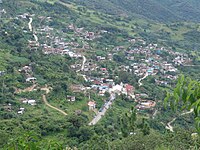
 From left to right: Tanetze de Zaragoza, San Isidro Reforma, Juquila Vijanos, Santo Domingo Cacalotepec


Municipalities edit

The district includes the following municipalities:[2]
| Municipality | Area km2 | 2005 Population |
Indigenous language speakers |
|---|---|---|---|
| San Andrés Solaga | 38 | 1,699 | |
| San Andrés Yaá | 37 | 378 | |
| San Baltazar Yatzachi el Bajo | 48 | 690 | |
| San Bartolomé Zoogocho | 23 | 381 | |
| San Cristóbal Lachirioag | 24 | 1130 | |
| San Francisco Cajonos | 26 | 371 | |
| San Ildefonso Villa Alta | 137 | 3,100 | |
| San Juan Juquila Vijanos | 37 | 1,908 | |
| San Juan Tabaá | 27 | 1,091 | |
| San Juan Yaeé | 93 | 1,344 | |
| San Juan Yatzona | 38 | 561 | |
| San Mateo Cajonos | 26 | 574 | |
| San Melchor Betaza | 37 | 919 | |
| San Pablo Yaganiza | |||
| San Pedro Cajonos | |||
| Santa María Temaxcalapa | |||
| Santa María Yalina | |||
| Santiago Camotlán | 333 | 3,089 | 2,461 |
| Santiago Lalopa | |||
| Santiago Zoochila | |||
| Santo Domingo Roayaga | |||
| Santo Domingo Xagacía | |||
| Tanetze de Zaragoza | 59 | 1,581 of | 1,327 |
| Villa Hidalgo | |||
| Villa Talea de Castro |
References edit
- ^ "Distrito 13 Villa Alta" (PDF). oeidrus. Retrieved 2010-08-22.
- ^ "Enciclopedia de los Municipios de México: Estado de Oaxaca". Retrieved 2010-07-08.
This article about a location in the Mexican state of Oaxaca is a stub. You can help Wikipedia by expanding it. |