Talessman
 | This user may have left Wikipedia. Talessman has not edited Wikipedia since 6 August 2014. As a result, any requests made here may not receive a response. If you are seeking assistance, you may need to approach someone else. |
Welcome!
Hello, Talessman, and welcome to Wikipedia! Thank you for your contributions. I hope you like the place and decide to stay. Here are some pages that you might find helpful:
- The five pillars of Wikipedia
- How to edit a page
- Help pages
- Tutorial
- How to write a great article
- Manual of Style
I hope you enjoy editing here and being a Wikipedian! Please sign your name on talk pages using four tildes (~~~~); this will automatically produce your name and the date. If you need help, check out Wikipedia:Questions, ask me on my talk page, or place {{helpme}} on your talk page and someone will show up shortly to answer your questions. Again, welcome! HighInBC (Need help? Ask me) 17:44, 19 November 2006 (UTC)
Maps edit
My compliments for the historic world maps. Keep up the good work! Sijo Ripa 21:31, 13 September 2007 (UTC)
Thank You For Putting that map of the Byzantine Empire, way much better than mine. Excellent Job
Your recent edits edit
Hi, there. In case you didn't know, when you add content to talk pages and Wikipedia pages that have open discussion, you should sign your posts by typing four tildes ( ~~~~ ) at the end of your comment. On many keyboards, the tilde is entered by holding the Shift key, and pressing the key with the tilde pictured. You may also click on the signature button ![]() located above the edit window. This will automatically insert a signature with your name and the time you posted the comment. This information is useful because other editors will be able to tell who said what, and when. Thank you! --SineBot 14:46, 24 September 2007 (UTC)
located above the edit window. This will automatically insert a signature with your name and the time you posted the comment. This information is useful because other editors will be able to tell who said what, and when. Thank you! --SineBot 14:46, 24 September 2007 (UTC)
- I have reverted your addition of the "500 AD" map to seemingly random pages. It may have a place, say on 6th century or History of Eurasia, but not on any article on any entity that somehow concerns the time period of 500 AD. In terms of design, well, you may want to reduce hue on the background map and use coloured layers, so the entities you indicate are visible in the thumbnail. --dab (𒁳) 20:31, 6 October 2007 (UTC)
Talessman, I must ask you again to stop adding your useless maps to all possible and impossible articles. Why don't you sit down and improve one of your maps until we can find some use for it? I am sure you can find something useful to do on Wikipedia. --dab (𒁳) 15:51, 19 October 2007 (UTC)
- you are revert-warring. review Wikipedia:Vandalism for your allegation that my and others' edits were "vandalism", and see Wikipedia:Dispute resolution for your options of proceeding with this (besides sitting down and actually improving your maps, that is). I can assure you that the time you will invest in forcing your maps onto articles regardless of opposition could be spent much more productively in creating a quality map that everybody will thank you for. --dab (𒁳) 16:45, 19 October 2007 (UTC)
When you take it upon yourself to arbitrarily go to every page the maps are on and delete them from those pages, that's vandalism. If you have a legitimate problem with the maps, you should explain what that problem is and provide information for how the map can be fixed. Just calling the maps "worthless", or saying they provide "too much information", doesn't cut it.
You took it upon yourself to delete these maps off of every page they were on, even articles you had never contributed to. You even deleted them off of articles that had no maps. Do these maps really intimidate you that much? They are simple maps, it's not like they are calling you names or threatening your otherwise "perfect" article. There's no reason to delete these maps off of the pages they are on. If you'd like to compromise, we can discuss that. But if you continue to just delete them off of every page they are on, I will continue to revert your vandalism. It's that simple. Thomas Lessman 17:38, 19 October 2007 (UTC)
Maps edit
Thanks for your praise! I enjoy making maps and it's nice to have the work complemented. If you haven't seen it, I've posted a complete gallery of my maps at User:Briangotts/maps. I very much enjoy your eastern hemisphere maps (I believe one of them is in the Khazars article, which I largely wrote). One thing I've noticed is that if I save maps in .png format rather than .jpg, there is significantly less distortion. I don't know enough about the different formats to tell you why that is, but it may come in handy to you in the future. Briangotts (Talk) (Contrib) 21:08, 15 October 2007 (UTC)
The article .png may shed some light on the difference between the two formats. I used to do maps in .jpg but now do .png exclusively. Some folks have adapted my maps to .svg format which uses a non-bitmap system and those maps look much better, but I don't have the technical know-how or the program to do that. Briangotts (Talk) (Contrib) 21:11, 15 October 2007 (UTC)
Byzantine Empire edit
Let me just take some time to thank you for your contributions. I know this is old but I may have appeared offensive to you at the Byzantine Empire talk page. I admire your dedication and knowledge. So I apologize if I said anything - and good work!Tourskin 03:46, 24 October 2007 (UTC)
- great map - u have my vote for it if we can replace one of the older maps currently up there. Just one point about the wording - 565 was the empire at its greatest territorial extent, not at its height since it was large but weak and overstrecthd - once again thank you for your work and your kind offer for using one of your maps as a template!!! Tourskin 18:32, 24 October 2007 (UTC)
- Hello! I really like your work with the hemisphere maps and the new Byzantine Empire map of 565. A few small comments on the latter: In 565, the Gepids were still around, and the Avars had not expanded up to the middle Danube. The Lakhmids (not Lakimids) were not that far in the interior of Arabia (which was pretty much no-man's land), and their state actually was centred along the southern shore of the Euphrates (their capital Hira was south of Ctesiphon). Also, in 562 Lazica was officially recognized as part of the Roman Empire. Furthermore, it is very doubtful whether the Nubian kingdoms actually extended to the Red Sea. They were most likely confined to the lands around the Nile valley (at least, most atlases I've seen show them that way). BTW, I have just finished a map of the Roman Empire in 400 AD (and one for 565 AD is under way). If you have any comments or suggestions, they are welcome! Cheers, Cplakidas 22:02, 31 October 2007 (UTC)
- Thanks for the compliments! I too had to piece the map together, from here. In full resolution, it's pretty big. If you really intend to do a world map on this scale, you've got my sincere respect and admiration. Now, for the sources on the above: I have access to a very good Greek source, with maps and all, the "History of the Hellenic Nation" from the national Academy of Greece. Obviously, since this is not available to you, I'll try to provide some extra sources. The Gepids were not conquered until 567-568, see e.g. this, so they were still in modern Romania and Hungary. On the Lakhmids and their capital at Hira, I don't have a singe source in mind. There can be little talk of actual "control" of the desert interior, where nomad tribes roamed, in a situation parallel to that of the Romans in Africa. Good and fairly accurate maps of pre-Islamic Arabia are [1], [2] and [3]. On the treaty ceding Lazica, see [4]. As for the Nubian kingdoms, the Historical Atlas of Islam, Harvard Un. Press, is the one source that comes to my mind (because I have it), but I've seen it elsewhere too. Most of the stuff in Wikipedia is pretty good and accurate, at least if it is pre-1000 AD, when various "national" considerations start to come into play. BTW, an excellent web atlas (in case you don't already know it) is Euratlas. Cplakidas 23:03, 31 October 2007 (UTC)
- Well, there was no big difference between 540 and 565, largely the same states were around, with much the same territory. I think the Ghassanids are OK, and the Lakhmids just need to have their northern border moved right on the Euphrates, and their southern border a bit more to the north (with Bahrain and the area of modern UAE shown as being under Persian control). BTW, for the 600 map, I think it was only in 602 that the Lakhmids were fully incorporated in the Persian state. As for the other Arab tribes, there is really no way to say exactly where the border should be. That's the problem with using a line to designate a border in areas where borders were as static as sand dunes... Kindah, I think, had declined and dissolved by 565, and the exact extent of Persian rule over Yemen is unknown, but even if the Sassanids occupied only Sana'a, most of it was a Sassanid vassal (BTW, Hadramaut, not Hadramaur). Oman was under the Julanda tribe (Sassanid vassals) and the Hanifah tribe were also Sassanid vassals. I hope it helped. Cplakidas 21:31, 1 November 2007 (UTC)
- I think it's OK now. I am waiting forward to see the one about 600. BTW, my name is Constantine. Cheers, Cplakidas 17:21, 2 November 2007 (UTC)
images edit
Please dont add maps as you did to Rashtrakuta Empire, because the article already has two maps drawn in a style that has been accepted as "standard" by the India History group.Dineshkannambadi 21:49, 31 October 2007 (UTC)
More mistakes edit
I found a mistake of the map in Image:East-Hem 1025ad.jpg, that is the mis-speling of Champa, in the map it is written "Champa Kngdom" Mimihitam 14:00, 10 November 2007 (UTC)
- Thank you for pointing that out. Actually I abbreviate Kingdom to King. or Kngdm in quite a few of the maps, to make the words fit together better. I also had to abbreviate the names of some countries, like Pomerania, which I had to shorten to "Pom". It's unfortunate, but it was necessary due to space restrictions. Thomas Lessman 15:06, 10 November 2007 (UTC)
Another one, on Image:East-Hem 1200ad.jpg - Wales has a typo "Whales" ;-) Nice maps, though! - MPF 15:30, 14 November 2007 (UTC)
- Haha, that's actually kind of funny! Thanks for pointing it out; I'll correct it and upload an updated version when I get a chance. Thomas Lessman 15:56, 14 November 2007 (UTC)
Conflict of interest edit
Hi. You're not really supposed to create or edit articles about yourself or your organization; take a look at the Conflict of Interest Guideline:
Thanks for your understanding and we very much appreciate the other work you're doing for Wikipedia. --A. B. (talk) 07:05, 18 November 2007 (UTC)
- Hi AB. I didn't create either of the articles you mentioned and I don't know who did. But I understand your point about possible conflict of interest. That's why the only edits I performed on those articles was to correct minor errors (like on the original article about me, which erroneously stated that I was a candidate for Congress from Kansas City; I'm actually from Topeka.) I would have liked to add that I'm King of the Nerds, good looking, and I have good parents, but I didn't do so because I was only fixing some real inaccuracies, not embellishing. I also made sure to sign my name to my edits so that readers could that I did do some edits to the pages, and could look back in the page archives if they have any questions about CoI.
- As for the MDM article, same thing applies. I'm not trying to advertise or embellish anything. I saw it had been tagged due to someone else's concerns. I read the concerns and did what the tag asked - provided the requested references and more information to show the MDM Network wasn't "just a website", as one of the tag's concerns. If it really reads like an advert, perhaps my writing style wasn't up to par at the time. So if its style can be improved, then let's do that instead of deleting it. Respectfully, Thomas Lessman (talk) 16:28, 18 November 2007 (UTC)
Welcome to WikiProject Former countries edit

Welcome, Talessman, to the Former countries WikiProject! Please direct any questions about the project to its talk page. If you create new articles on a former territory, please tag their talk page with our project template {{WPFC}}. A few features that you might find helpful:
- The project's Navigation box points to most of the pages in the project that might be of use to you.
- Most of the important discussions related to the project take place on the project's main talk page; you may find it useful to watchlist it.
- If you wish to use the template {{Infobox Former Country}}, please read the instructions before you get started
- Within the project there are also several subprojects. Here are some that you may be interested in:
If you have any questions, please feel free to ask me or any of the more experienced members of the project, and we'll be very happy to help you. Again, welcome, and thank you for joining this project! Domino theory (talk) 17:24, 18 November 2007 (UTC)
Problem with Image:East-Hem 200 BC map edit
I've been asked to comment on the said image. In my opinion, labeling Nanyue/Nam Viet "Vietnam" is misleading and inaccurate, as it was a state that could not conclusively be said to correspond ethnically to either modern Vietnam or China. --Nlu (talk) 02:48, 22 November 2007 (UTC)
- Sorry, as has been pointed out, I had mixed up this image with Image:East-Hem_200bc_web-sm.jpg, which is what my comment above refers to. --Nlu (talk) 18:21, 22 November 2007 (UTC)
Maps edit
No problem, I think it's totally appropriate to demonstrate the spread of the German people in an article about the German people, as well as the political changes they made to European territory...just, as I say, it would probably help if they zoomed in a bit more, since they show parts of the world that aren't relevant to the eras of German history they depict. Michael Sanders 22:37, 24 November 2007 (UTC)
1025 edit
Thank you for editing this map according to my request. Gantuya eng (talk) 14:39, 12 December 2007 (UTC)
- Not a problem, Gantuya, and thank YOU for sending me the information to help correct the map! Any time you see a possible error on a map I've created, please either post a message on the map's talk page or send me an email, letting me know how the map is wrong, how I can correct it, and include any source information you have to back up your claim. It REALLY helps when you copy the map to your computer and redraw the information so I can see exactly what needs to be changed. That's exactly what you did, and it really helps! Respectfully, Thomas Lessman (talk) 16:21, 12 December 2007 (UTC)
Zhukaiguo edit
Hey Thomas, Zhukaiguo Culture covers a broad period from the Longshan to Erligang. Longshan is the large, pre-Xia archaeological Culture, while Erlitou/Erligang is either late archaeological or early historical, depending on your view of Xia Culture / Xia Dynasty. This makes them contemporary to the Xia and Pre-Shang cultures to the southeast and to the various Longshanoid and Erlitou cultures that existed to the west and south (The pre-Dynastic Zhou not appearing in the southern Loess/Wei River Valley for another 500 years after the end of Zhukaiguo). I'm not sure what would be contemporary to the north, but I believe Lijia Culture would be the late contemporary to the direct east. Hope that was helpful. Elijahmeeks (talk) 23:44, 21 December 2007 (UTC)
! edit
Your maps are realy cool. and i'm impressed at the effort you must have dedicated to them... I'd like to help a bit with Korea and China, as they look a bit out of line. But by far, those are the best I've seen of asia. o.d.s.t. : feet first into hell (talk) 09:03, 23 December 2007 (UTC)
- Thank you Odst, I appreciate any info I can get! I noticed this morning that I had Goguryeo's borders wrong, and I fixed it on the Image:East-Hem_500ad.jpg and some other edits for other years. If you can show me what to correct, I'm happy to fix it! Thomas Lessman (talk) 16:36, 23 December 2007 (UTC)
- Well, Goguryeo's terrotory was almost always indefinite, but this is generally accepted by many to be: http://content.answers.com/main/content/wp/en-commons/thumb/8/84/250px-Three_Kingdoms_of_Korea_Map.png some Korean and Chinese records describe that Goguryeo moved up its borders to easily defendable rivers. I am also sure that liaodong was under Goguryeo control from at least around 312. I have detailed maps of the Korean peninsula, and I'll send em over as soon as my scanner is fixed. There's also a mixed claim by a number of researchers saying that Baekje owned a part part of the chinese mainland for quite a short time. I'm looking into this, but I've only found 2 actual historical records that proves this. o.d.s.t. : feet first into hell (talk) 20:46, 23 December 2007 (UTC)
Korean kingdom's territory edit
Hi, I'm Historiographer. I'm editing a many your maps (BC 500, BC 200, AD 475, AD 476, AD 500, AD 565, AD 600, AD 800, AD 900, AD 1025, AD 1100). Of course, all my editing map is limited to Korean kingdom's territory. If you be interested in my editing map, you would like to hear from me. --Historiographer (talk) 02:43, 25 December 2007 (UTC)
Taiwan edit
Hi,
First of all, your maps are awesome =D
Regarding Taiwan, I'm not sure why you labeled Taiwan as "Tapanga" on all of the maps. As far as I know, there were no organized states in Taiwan until Dutch and Spanish colonization in the 17th century. Shouldn't Taiwan be labeled then as "Taiwanese aborigines" much as Australia, Papua, Siberia etc. are labeled on your maps? Also I think the border of the Song Dynasty is too far south in Shanxi. As far as I'm aware, Liao controlled only the area around Datong and not further south. -- ran (talk) 21:15, 7 January 2008 (UTC)
- Hi Ran, the reason I labeled it "Tapanga" is because one of my sources states that the Chinese used that name for the island. Granted, it was probably too much to call it Tapanga on ALL of the maps, and you are correct that there were no organized states on the island until colonization from Europe. I thought once of replacing "Tapanga" with the name of the most prominent tribes of the island, but there's not enough historical info available for me to do that at this time.
- Regarding the Song Dynasty south border, could you show me where the correct border should be, and include your source info? If so, I'll be happy to fix it. Thomas Lessman (talk) 21:37, 7 January 2008 (UTC)
The Chinese didn't call it "Tapanga". Chinese historical records tend to be pretty vague about islands in the East China Sea; names that most likely (but not 100% certainly) refer to Taiwan include "Yizhou" and "Little Liuchiu".
If "Australian Aborigines", "Papuans", etc. work, then surely "Taiwanese Aborigines" would work as well? -- ran (talk) 23:05, 7 January 2008 (UTC)
Does wikipedia work as a source? =)
If you want something better I'd be happy to look for it for you. -- ran (talk) 23:08, 7 January 2008 (UTC)
- That map on Wikipedia will work as a source. I actually hesitate to use Wikipedia very often, because of some of the editors on here (those whose egos are more important to them than article accuracy...). However, I've seen some well founded facts on Wikipedia, so I have to play it by ear. In the case you presented, the creator of those maps has done a lot of work that I'm generally impressed with, so I'm happy to accept him as reference. My ONLY problem with it is that I'm not sure if these borders are accurate for the specific year in question. For example, those borders may be good for 950 AD, but what about 1000 AD?
- As for Taiwan or Tapanga or Yizhou, which one has more use in historical references? I don't want to use "Taiwanese Aboriginis" because honestly the island is too small and historically non-important for such a large amount of text. Sorry to say it that way, but it's the truth. Now, I'd be happy to use "Yizhou" to replace "Tapanga", but I'd be happIER if there was a prominent tribe known to the Chinese during various eras. If you have info like that, I'd be happy to include it also. Thank you in advance, Thomas Lessman (talk) 23:51, 7 January 2008 (UTC)
I'm sorry, forgot to mention regarding the map. Remember that the map template I use is different than some other maps in terms of geographical shape. Thus China looks more "squished" on his map than it looks on my map, where it appears more spread out. It's not an error on either of our parts, just a difference in the way the geography is portrayed. One user, Bogomolov.Lp, has done a great job showing me how my map was off compared to the Euratlas sourcemap I used. Sometimes it's not easy figuring out the difference in borders when the geography is more spread out... Thomas Lessman (talk) 23:54, 7 January 2008 (UTC)
- I think the Northern Song / Liao border was reasonably stable. The Song-Liao Shanyuan Treaty was signed in 1005 and held for a hundred years. This border should hold until the 1120's when Liao was partitioned by Jin and Song.
- For Taiwan, I think it is factually wrong to label it with a single tribe, and misleading to label it "Yizhou" (just as misleading as "Tapanga"). -- ran (talk) 06:06, 11 January 2008 (UTC)
Tibet history enhancements edit
Hi Thomas! Thank you for your kind note. I am travelling at the moment and staying with friends who only have a very slow dial-up internet connection (which has taken most of the day to link up to on my machine) so I probably won't be doing much work on the Wikipedia until I get home in 3 weeks or so (also, of course, most of my reference material is there not here but at home). However, if I can be of any help in the meantime do drop me a note and I will get back to you as quickly as I can. I, too, would love to get Tibetan articles up to speed as much as possible. Unfortunately, I know lttle about Korean history - my own interests focus mainly on South and Central Asian, Tibetan, West Indian, Chinese, Silk Road and Australian Aboriginal history and culture. Please let me know if I may be of help in any of those areas. Cheers and all best wishes, John Hill (talk) 07:41, 14 January 2008 (UTC)
3RR edit
Reported for 3RR violation here. One Night In Hackney303 21:39, 23 January 2008 (UTC)
- Uh, I only reverted your edit once. Not 3 times. The only other 3 Reverts I've had to do was to prevent needless deletions of maps, or to stop vandalism. If you don't like me reverting your edits, then don't make edits or deletions where they don't need to be made. Thomas Lessman (talk) 21:45, 23 January 2008 (UTC)
- Who said you were being reported for the edit to your article? Please read the report before putting your foot in your mouth, it is helpful. Thanks! One Night In Hackney303 22:18, 23 January 2008 (UTC)
3RR (2) edit
Please watch out for 3RR on Thomas Lessman. Nakon 03:42, 24 January 2008 (UTC)
Where? Watch out for 3RR on Nakon too? I haven't been "revert warring", just adding legitimate info to articles and restoring work when it is unfairly deleted by biased editors with grudges. Thomas Lessman (talk) 03:47, 24 January 2008 (UTC)
![]() If you have a close connection to some of the people, places or things you have written about on Wikipedia, you may have a conflict of interest. In keeping with Wikipedia's neutral point of view policy, edits where there is a conflict of interest, or where such a conflict might reasonably be inferred from the tone of the edit and the proximity of the editor to the subject, are strongly discouraged. If you have a conflict of interest, you should avoid or exercise great caution when:
If you have a close connection to some of the people, places or things you have written about on Wikipedia, you may have a conflict of interest. In keeping with Wikipedia's neutral point of view policy, edits where there is a conflict of interest, or where such a conflict might reasonably be inferred from the tone of the edit and the proximity of the editor to the subject, are strongly discouraged. If you have a conflict of interest, you should avoid or exercise great caution when:
- editing articles related to you, your organization, or its competitors, as well as projects and products they are involved with;
- participating in deletion discussions about articles related to your organization or its competitors;
- linking to the Wikipedia article or website of your organization in other articles (see Wikipedia:Spam);
- and you must always:
- avoid breaching relevant policies and guidelines, especially neutral point of view, verifiability, and autobiography.
For information on how to contribute to Wikipedia when you have conflict of interest, please see Wikipedia:Business' FAQ. For more details about what constitutes a conflict of interest, please see Wikipedia:Conflict of Interest. Thank you. --Hu12 (talk) 03:55, 24 January 2008 (UTC)
- Again, I didn't create the article on Thomas Lessman, someone else did. I corrected minor inaccuracies. Someone said the article needed more information so I added it. Someone else said the article needed references, so I added them. He then keeps deleting them, saying they aren't good enough for him. Others have reviewed my edits and said they were fine and did not fall under conflict of interest.
- All of my edits are easily seen by using the page history feature. I state what the edits I made and why I made them. I have nothing to hide and I'm not embellishing or trying to sneak anything by anyone. All I did was what was asked, to make it a better article. Thomas Lessman (talk) 04:02, 24 January 2008 (UTC)
Help with diffs diffs edit
If you want to provide a "diff", select the history tab on some page, e.g., this one, check radial circles next to the two revisions you want to compare, and push the "compare selected versions". TableMannersC·U·T 06:51, 24 January 2008 (UTC)
Speedy deletion of Image:Bullock the Hutt 01-2004.jpg edit

Please do not make personal attacks. Wikipedia has a strict policy against personal attacks. Attack pages and images are not tolerated by Wikipedia and are speedily deleted. Users who continue to create or repost such pages and images in violation of our biographies of living persons policy will be blocked from editing Wikipedia. Thank you.
If you think that this notice was placed here in error, you may contest the deletion by adding {{hangon}} to the top of the page (just below the existing speedy deletion or "db" tag), coupled with adding a note on [[Talk:Image:Bullock the Hutt 01-2004.jpg|the article's talk page]] explaining your position, but be aware that once tagged for speedy deletion, if the article meets the criterion it may be deleted without delay. Please do not remove the speedy deletion tag yourself, but don't hesitate to add information to the article that would would render it more in conformance with Wikipedia's policies and guidelines. nancy (talk) 14:01, 24 January 2008 (UTC)
Not cool to remove speedy delete templates on articles or images you created/uploaded edit
![]() Please do not remove speedy deletion notices from pages you have created yourself, as you did with Image:Bullock the Hutt 01-2004.jpg. Please use the {{hangon}} template on the page instead if you disagree with the deletion. Thank you. TableMannersC·U·T 14:18, 24 January 2008 (UTC)
Please do not remove speedy deletion notices from pages you have created yourself, as you did with Image:Bullock the Hutt 01-2004.jpg. Please use the {{hangon}} template on the page instead if you disagree with the deletion. Thank you. TableMannersC·U·T 14:18, 24 January 2008 (UTC)
Sorry TableManners, I hadn't realized I broke a wiki-rule. I saw that it had been set for deletion, I was writing the challenge to it, and then saw that it was deleted before I had the chance to object. I'm trying to find out how to set the {{hangon}} on an image that was deleted too quickly for me to put the template on. Thomas Lessman (talk) 14:33, 24 January 2008 (UTC)
Off topic conversation continued from AfD edit
I was going to reply there, but this line of the conversation also doesn't really belong on that discussion page.
Your edit warring over the inclusion of your maps wound up bringing a whole lot of attention to your account yesterday. That isn't wiki-stalking. That isn't wiki-bullying. That was your edit warring bringing attention to yourself. If you can provide reliable sources (nothing published by yourself or any organization that you are involved with) that establish notability, the article may still be kept. The "wiki-bullies" are giving you 5 days to prove or fix your article. Maybe you should start focusing on that instead of looking for cabals where there are none.
Please explain to me how the following comment relates to your article, your notability, and whether sources can be found that verify information for the article...
- Pure wiki-bully bull. Thomas, the more the wiki-bullies do, the more they prove their critics to be right. Their favorite slur is the sockpuppet, but of course, they lack the technical ability to distinguish one user from another when they are on the same computer. Instead of deleting the Thomas Lessman and MDM article, I suggest deleting wikipedia.
You'll have to excuse me if I didn't see it. --Onorem♠Dil 17:27, 24 January 2008 (UTC)
Message for Tallessman edit
I left a message on the AFD for you. Spartaz Humbug! 17:33, 24 January 2008 (UTC)
You deserve one of these edit

|
The Graphic Designer's Barnstar | |
| Thanks for continuing to participate and upload your maps. Maps such as Image:Persia 600ad.jpg and Image:Asia 800ad.jpg are a real plus for wikipedia. TableMannersC·U·T 06:42, 30 January 2008 (UTC) |
400 Asia map edit
I think that there are two Xia-related problems with it:
- Xia didn't exist yet. (It didn't start until 407).
- The placement of its territory is wrong. The territory that it occupied was the region directly south of the Yellow River in the "hump" area, which you currently have assigned to Later Qin. (After Xia broke away, Later Qin was reduced to the Guanzhong region, pretty much.)
Thanks for the work on it. --Nlu (talk) 16:04, 31 January 2008 (UTC)
- I'll look into it Nlu. Thanks for bringing it to my attention! Respectfully, Thomas Lessman (talk) 18:04, 31 January 2008 (UTC)
Sure enough Nlu, I double checked one of my source maps, the huhai.net map of China,304-420 AD. The China borders are off just a little. I'll add it to the list and fix it next time I update that map. Thank you again, Thomas Lessman (talk) 18:20, 31 January 2008 (UTC)
Thanks + SVG ! edit
Many thanks for your maps : I dreamed of this since I'm 8 years old ! So do them slowly... one by month, no rush...
After what : please take contact with commons:user:Sting, commons:user:Sémhur, or commons:user:MapMaster. Sting made and make AMAZING SVG maps, and in your case, SVG may be easier to edit (but will have to be more protect (?)). Sémhur followed Sting, but have now a bigger experience in SVG Historical maps. Mapmaster also have pretty good experience in historical maps. Anyway, Sting (, Sémhur, and MapMaster) can probably help you [give advices for sure ! help you to edit your maps : maybe] if you fell that the SVG transition is need, especially if you request their advices ;).
Other thing : your maps are currently only available on the English Wikipedia only. This can be more convenient to raise support and corrections. But it will soon or late be need to upload your maps on Wikimedia_Commons, this allowing ALL the Wikipedia to use your maps (jpg, png [better that jpg!] or SVG as well).
Pic up the assistance that you need :
-
 Sting
Sting -
 Sémhur
 -
 MapMaster


![[1]](http://www.mideastweb.org/sau-map500.jpg)
![[5]](https://upload.wikimedia.org/wikipedia/commons/2/29/China_11a.jpg)
All this to say : THANKS ! 210.203.61.15 (talk) 18:52, 31 January 2008 (UTC)
- Ask feed back about these issues
- Hello, can you notice me (on this section) if you have noticed my proposals : 1/ PNG and SVG can be better than jpeg/jpg, it's an issue to think ; 2/ your maps will be soon or late need on Wikimedia_commons ; 3/ you can find SVG map assistance (Sting, MapMaster, Sémhur)
- Thanks to answer just here, allowing me to know that you are aware of these 3 issues (the final answers are not need : that's your business). 210.203.61.15 (talk) 10:56, 10 February 2008 (UTC)
Hello Thomas edit
Hi Thomas, i m very impressed by your maps, thats a lot of work for a single person. I am using your maps to create other maps for the turkish Wikipedia, to show the common history of the turkic speaking peoples with blue colored areas: tr:Kullanıcı:Erdall/Türk Tarihi/Kronoloji. I'm waiting strained for the remainder. I've made the map of AD 1300 without your help: tr:Resim:Türk_Tarihi_1300.jpg, because of the giant mongol empire it was more simple as other centuries. When do you continue? Greetings ---Erdal (talk) 02:27, 5 February 2008 (UTC)
- Excellent Erdal, I'm glad to see someone else taking this on also. I get some help from various people who are interested in helping this project. The blank map I use is available here, (http://www.thomaslessman.com/History/images/blank-East-Hem.jpg). Feel free to use it if you like the size and look. So far I've finished 30 of them, from 1300 BC to 1200 AD, and I'm also working on another 4 (including 1300 AD). Good luck and feel free to use my maps for references; I'm sure your maps will help me finish more modern times. Respectfully, Thomas Lessman (talk) 02:38, 5 February 2008 (UTC)
Because... edit
Hi Talessman. I'm Historiographer.
I will illustrate the why should I remove your history map. because some error in your maps.
- Mahan confederacy were annexed in the 369 by King Geunchogo of Baekje. therefore in present-day Jeolla province was mahan territory. (According to Territory History of Korea.)
- The map you removed was in 200 AD; your point above takes place 369, during the actual 3-kingdoms period (not the proto-3 Kingdoms). That's 169 years after the my map -> my map is good, but have not to be use for the year 300 to 400. Thomas Lessman (talk) 03:50, 5 February 2008 (UTC)
- Okjeo, Dongye's territory too extensive. King Taejo of Goguryeo reduced Okjeo and Dongye's territory.
- I used Javierfv1212's map of the world in 200 AD for reference in Korea, along with various Wikipedia articles. If those maps are wrong for this exact year (200 AD), please send me a map that covers this area during this year.
- Sometimes ago I'm send my editing map to you. showing my editing map? This maps information from a reliable source that high school Korean history textbook, Territory History of Korea and Historical Atlas of Korea etc. Thanks... --Historiographer (talk) 03:31, 5 February 2008 (UTC)
- The map you sent me was (I believe) the one that currently exists for the Korea articles, Image:Three_Kingdoms_of_Korea_Map.png. That's a good map but it is for a later period. If you have info to show my map for 200 AD (or any other map) may be inaccurate, please send me source info and a map to show me the correct borders, and I'll happily correct them! Respectfully, Thomas Lessman (talk) 03:50, 5 February 2008 (UTC)
- PS: I'm sorry to say that, but take "high school Korean history textbook" cautionously. I explain why... I'm a big fan of the Tang raise (~580 -> ~670), accordingly, I had read many pages about Sui-Goguryeo wars and Tang-Goruryeo wars : I look this opposition really interesting, and I sincerely don't care which of the both eventually win, lost, or keep the statu-quo. Recently, looking in the NTNU library, I was astonished to read a book "An History of Korea", translate from korean. The book was talking about all the major campaigns (598, 612, 613, 614, 645, 661, 667) which were successful for proto-koreanese troops... and conclude by noticing the force and courage of Goguryeo. No words about the 668 defeat and the following 10-years difficult but victorious struggle against Tang attempt to fully control the Korean peninsula. Also, I now take historical books from Korea, about Korea, or from France, about France as well really cautionously. They are helpful, but we can't completely trust them and their POV [point of view].
- 210.203.61.15 (talk) 10:41, 10 February 2008 (UTC)
Maps edit
Thanks for your critique, Thomas.
Actually it reminded me of something I tried to tell you via your site's email but failed (the email was bounced or something - check that link). It was about the extension of the Seleucid Empire c. 200 BCE: you basically give them all Pakistan west of the Indus but that's not what at least the Wikipedia article says: it says that Seleucus ceded vast territories from the Indus to present-day Afghanistan to Chandragupta in 305 BCE. The maps illustrating that article seem to show Seleucus kingdom's extension before that treaty actually.
As mentioned the email bounced and I gave away but I believe you would like to take notice of this apparent error.
Another possible issue in that 200 BCE map could be the extension of Seleucids and Ptolemaics in southern Anatolia. I believe you are reflecting the situation after the 2nd Punic War, when Seleucids lost some west Anatolian territory to Pergamum (even if the war ended several years after 200 BCE, it's still "circa") but, anyhow, apparently Ptolemaic Egypt had territory in coastal southern Anatolia that is not reflected in that map (check this map for instance). I don't know for sure but I suspect there's no reason for Ptolemaic Egyppt to have lost territory in that period. Check that yourself.
I think that your maps are very ambitious and have a great potential. The main problem they could have is to miss some details here and there, like the ones mentioned above, because of that huge global vision. I also think they would look better if instead of using physical maps for the background, you used plain ones instead, using colors for the states. After all they are political maps, aren't they?
In any case, you have my applause and support. Enjoy. --Sugaar (talk) 12:49, 12 February 2008 (UTC)
Hi edit
WOuld you mind reminding me where you got the map template for your maps please ? I know it s some site on the web, but i forgot the address. Hxseek (talk) 08:02, 15 February 2008 (UTC)
Dear American editor
Theatre is spelled this way by most English speaking people in the world. In America it is spelled theater. That is the difference between Commonwealth English and American English and before reverting a proper edit you should read the guidelines that say explicitly that if an article is CE or AE it should stay that way. It really gets annoying because we second language speakers seem the only ones capable of knowing both English orthographies. Wandalstouring (talk) —Preceding comment was added at 09:47, 15 February 2008 (UTC)
Historical maps of Korea edit
Hi, Thomas. I recently make a maps about historical maps of Korea. And I send you info to practically correct maps. I request you should looking for my maps.
Look here! →User:Historiographer/My history maps Thanks!!! --Historiographer (talk) 14:59, 10 March 2008 (UTC)
- Excellent work, Historiographer! I hope you put some of those up on the various Korean History articles. I see that I have some work to do now making corrections to my maps. But again, nice maps Historiographer! Thomas Lessman (talk) 18:12, 10 March 2008 (UTC)
Image:East-Hem 700ad.jpg edit

The map depicting boundary of the Tibetan Empire (700AD) including the present North East India more specifically the Assam region is not a historical fact and it is absurd. The location and boundary of Gauda region is also wrong. Assam and adjoining areas from Tista river in the west to Sadiya and Patkai range in the east and Sylhet / Dhaka in the south was then part of the powerful Kamarupa kingdom of Assam and lower, down there was Tripura....Gauda was further west mostly in the west bank of the present Brahmaputra river in Bangladesh. The powerful Mlechchha dynasty was ruling Kamarupa kingdom in 700 AD.Porikolpok Oxom (talk) 19:44, 12 March 2008 (UTC)
- Hi Porikolpok Oxom. I got those borders from a map of Asia in 800 AD that showed Tibet's borders, as well as from the History of Tibet article, which described Tibet ruling those lands in 700 AD. If you could show me some better sources, and could send me a map with the correct borders, I'd be happy to correct them. Respectfully, Thomas Lessman (talk) 22:58, 12 March 2008 (UTC)
- Hi!, No Indian and Assam history sources confirms that. Not even have mentioned it for a single time anywhere....Unfortunately, our online-historical data base is very less...however, there are hundreds of books and research documents available on Assam history. You can refer history section of the further reading part in Assam...here i mention two of these books.
1. Gait, Edward Albert 1863-1950 (1926), A History of Assam, Calcutta: Thacker, Spink & Co. 2. Barpujari, H. K. (ed.) (1990), The Comprehensive History of Assam, 1st edition (ancient-early middle age), Guwahati, India: Assam Publication Board
I donno how will you be able to refer these books. Sites like amazon may help you...or you can contact researchers in India and in Assam.I will also dfntly try to provide you with resources and probably with a correct map in next few days. Thnx.Porikolpok Oxom (talk) 06:32, 13 March 2008 (UTC)
- The Image:Tibet 800ad.jpg is also imperfect showing Tibet inside Kamarupa kingdom in Assam. I am preparing corrected maps and will upload these in wikimedia commons. Thnx.Porikolpok Oxom (talk) 08:05, 13 March 2008 (UTC)
- Kindly refer two maps in the images 1. Kamarupa 7th-8th Century AD.jpg and 2. Kamarupa 7th-8th Century Cities.jpg on Wikimedia Commons. These are created by me. Hope you will change the boundaries of the maps showing Tibetan Empire.Porikolpok Oxom (talk) 11:47, 14 March 2008 (UTC)
The Edward Gait book is available online (google books), but I doubt it will have a lot of information on the Kamarupa kingdom, which contains some information which you might find of interest. The map given there is also indicative of the boundaries of the Kamarupa kingdom. Chaipau (talk) 17:22, 14 March 2008 (UTC)
Plz incorporate one more revision yourself to show that the areas close to the joint boundaries between Kamarupa, Gauda and Tripura down south constituted with low-lying land and with the large (probably then little larger) Mouth of Brahmaputra and Ganga. I am sorry for not showing it properly. I will revise these maps. Porikolpok Oxom (talk) 23:23, 14 March 2008 (UTC)
One more with the 7th-8th century cities inside:

- Hi, I have seen all your world maps. Nice creations. However, firstly in one, I have found a wrong position of Manipur. Secondly, till 8th-9th century it is evident that the western border of Kamarupa formed the Tista in the northern parts and Brahmaputra in the southern parts. That means places like North Bengal in present India and Dhaka and the district of Sylhet in present Bangladesh were parts of Kamarupa. This is supported by the copper plat inscriptions of Kamarupa kings found in these areas, early Muslim records and also by the similarities between the local languages. However, it seems Kamarupa lost these areas around 10th-11th centuries and later these areas became parts of Muslim-Bengal (leaving some parts under Tripura). Therefore, I believe that this part of the maps require some amount of revision. Thanx.Porikolpok Oxom (talk) 23:12, 14 March 2008 (UTC)
- Hi I request that these discission be taken to Talk:Kamarupa (History). Also, the coastal boundary was further north around that time, and Kamarupa had access to the sea. Chaipau (talk) 13:17, 17 March 2008 (UTC)
Maps edit
Dude, ur maps are awesome. Don't get us wrong. I think we just need something a little more specific and less redundant. Respectfully, Tourskin (talk) 05:41, 21 March 2008 (UTC)
- Thanks Tourskin, I appreciate your note. What I don't understand is, why remove the map that shows more detail and valuable information? Too many times I've read articles, looked at their maps, and left with no real idea of what the subject's world was like. It's very helpful to see info like the physical geography of a nation's lands, whom the nation interacted with (like neighbors, enemies and allies, trade partners, etc.)
- I respect your opinions, so how can we compromise with editors so that the articles keep a version of the East-Hem maps (or a zoomed-in version)? It's a shame if we remove relevant and valuable information from articles, leaving readers with less understanding of the subject. Respectfully, Thomas Lessman (talk) 16:24, 21 March 2008 (UTC)
Lead edit
Hey, I have added in my own suggestion for the Byzantine Empire's lead, please take a look at the talk page. I know you haven't participated much in discussion for this, but I think it would be a good idea to alert all notable editors. Also, lets not forget your maps, we should talk about them too. Tourskin (talk) 21:11, 24 March 2008 (UTC)
Maps edit
Ok I will put forward your case, because for the work you have put in you deserve a lot of credit and you seemed to be under fire for making bold constructive edits. Don't worry about not participating in the other discussion about the Lead if you're busy, its totally cool.
Respectfully (and very respectful and grateful for your contributions)
I like the map Image:NE 600ad.jpg : but in 600 there were several kingdoms in Armorica, not ONE kingdom of Armorica. Regards. Shelley Konk (talk) 17:19, 3 April 2008 (UTC)
- Thank you Shelley. You are correct; though I believe it's safe to call it the "Kingdom of Amorica" in a large-scale map such as the east-hem maps. The only reason I can't show the smaller kingdoms of "Amorica" is because of the scale. A more zoomed-in map could depict the borders of those kingdoms, along with cities, battles, etc.
- I pieced the East-Hem base map (background, geography, etc.) from this topographic map <http://en.wikipedia.org/wiki/Topographic_map#Global_1-kilometer_map>. There are other maps out there too, some with no geography features, etc.) You can use different programs to edit them (I use PhotoShop, but GIMP is a good program and it's free). Respectfully, Thomas Lessman (talk) 17:49, 3 April 2008 (UTC)
You could name them Breton kingdoms (of Armorica), or something similar, using a plural, or ... just Brittany, which is shorter, and as accurate: people who will search Brittany will find more information. Shelley Konk (talk) 21:56, 3 April 2008 (UTC)
- Good point, Shelley. I'll make a note of that and make the changes when I update those particular maps. Thank you for the suggestion! Thomas Lessman (talk) 21:58, 3 April 2008 (UTC)
Speedy deletion of Image:NE 1200ad.jpg edit
A tag has been placed on Image:NE 1200ad.jpg requesting that it be speedily deleted from Wikipedia. This has been done under section I8 of the criteria for speedy deletion, because it is available as a bit-for-bit identical copy on the Wikimedia Commons under the same name, or all references to the image on Wikipedia have been updated to point to the title used at Commons.
If you think that this notice was placed here in error, you may contest the deletion by adding {{hangon}} to the top of the page (just below the existing speedy deletion or "db" tag), coupled with adding a note on [[ Talk:Image:NE 1200ad.jpg|the talk page]] explaining your position, but be aware that once tagged for speedy deletion, if the article meets the criterion it may be deleted without delay. Please do not remove the speedy deletion tag yourself, but don't hesitate to add information to the article that would would render it more in conformance with Wikipedia's policies and guidelines. Lastly, please note that if the article does get deleted, you can contact one of these admins to request that a copy be emailed to you. Sdrtirs (talk) 01:24, 10 April 2008 (UTC)
- It's fine to move the NE and Asia maps over to WikiMEDIA now. Please leave the primary East-Hem maps here on Wikipedia, at least until someone figures out a way to transfer the entire file (including previous versions of the file). The reason is because these maps on Wikipedia show a unique progression of the maps, from their first drafts, corrections, and current versions. Those file histories are important when making the point that these maps have changed over time as knowledge of certain areas becomes more available. ALSO it is important in case changes have been made and are later found to be incorrect. Thomas Lessman (talk) 02:32, 10 April 2008 (UTC)
Your link to worldhistorymaps.com edit
Just tried the above link and it appears to be dead. -- RND T C 20:07, 13 April 2008 (UTC)
- Sorry RND, are you referring to my own www.WorldHistoryMaps.INFO site, or do you mean the www.worldhistorymaps.COM site, which I do not own? Thomas Lessman (talk) 15:41, 14 April 2008 (UTC)
Kangly/Kangar map edit
hello, Talessman, I want to express my gratitude for adding a long-sought by me good map of Kangar to the article. If you could, would you send me an e-mail with a (very) brief explanation of your technique and program(s) you use for map-making. Thank you, Barefact (talk) 06:45, 20 April 2008 (UTC)
- Hello Barefact. The program I use Adobe PhotoShop, but I've tested GIMP and it works just as well. There's not really much of a "technique" per-se. I try to use existing maps whenever possible (for example, the Euratlas maps are my base for most European borders). Then I manually draw the borders onto the new map. I also cross-check those borders with other sources, such as Wikipedia, other maps, etc. It's not perfect (Bogomolov. PL showed me that, compared to the different geography layout of the Euratlas maps, my borders in Russia are sometimes pretty far off). But whenever someone is able to show me a mistake on my maps, I am able to edit the original file, make the fixes, and upload a corrected version. Does this answer you question? Thomas Lessman (talk) 14:39, 20 April 2008 (UTC)
- Appreciate your answer. Looking at the quality of the map you've made, I thought that you know a better way then my tedious and labor-intensive (what I feel is a damb) method. But I guess the reality still rules, to get good results you need to sweat your pants Barefact (talk) 19:24, 20 April 2008 (UTC)
- Another interesting question, I never saw a map of Yuezhi, though there is a fairly definite verbal summary of Yuezhi territory before Huns took over and displaced/absorbed them. It reads:
- "Prior to the end of the 3rd century BC, the dominating force in the eastern part of Eurasia was the "state" confederation of nomadic and semi-nomadic tribes dominated by Uechji (Pinyin Yuezhi) tribe . The borders of this confederation can be outlined only conditionally. From the vague records of the later time, its southeast limits were at the left bank of the river Huang He from the headwaters before the northern bend to the south. The border further went to the north, covering western and eastern slopes of the Great Khingan. At the northern extremity it turned to the west, from Northern Mongolia and Southern Baikal area to the Sayano-Altai mountains. It included tribes of different origin, various languages and anthropological shape, and a non-uniform cultural and economic condition. The native territories of the Uechji were lands from the Nan Shans mountains in the south to the Altai in the north." (from Zuev 2000, introduction to Uechji/Yuezhi chapter)
- Would you be interested to look into this subject? Barefact (talk) 19:41, 20 April 2008 (UTC)
Parthian Empire edit
Hi Talessman, I just made a quick cleanup edit, nothing of substance. I'll stay to the side until you're done as you've done some outstanding work with this article this week. Great work! Hiberniantears (talk) 18:46, 23 April 2008 (UTC)
Khitan Empire edit
Hi Talessman, Remember, months ago you asked me to provide a source to justify the change of the boundaries of the Khitan Empire at my request. At last I got a source in my hands. The source I have is "Atlas of the History of Mongolia" for the 4th grade of secondary school. The authors are Otgony Purev (PhD of History), Sambuugiin Sodnom, Sanjaajavyn Damba. Printed in Ulaanbaatar in 1994. Gantuya eng (talk) 10:57, 25 April 2008 (UTC)
Korea maps edit
Hi, Thomas. I apologize for my tardy response to your question.
According to the many Korean history books, Korea's borders in 200 BC is similar that of Korea 108 BC. And the Liaodong peninsula had been taked by Gojoseon until 3rd century BC.
And some errors in your maps:
- Gojoseon was clearly exist. Some errors like [Gojoseon(?)] should removing in your maps.
- Ancient Korea borders should be changed or updated. (If you want to show the Korean History Textbook of National History Compilation Committee of Korea's many maps, I will send it to you.)
- Goguryeo's territory is too small. Goguryeo have ruled the Liaodong peninsula in 385-668, and also ruled the today's Jiandao in 2 Century-668. (refer to the my maps).
- In 1025, Goryeo's territory included part of northern korean peninsula. (See ''Image:History of Korea-1020.PNG''.)
- Why doesn's existence name of the Korea in your maps that 1300 AD, 1400 AD and 1500 AD? Goryeo had not direct colony of Yuan, just became the tributary of Yuan until 1350s. And Joseon Dynasty (1392-1910) also doesn's existence in 1400 AD and 1500 AD.
I request that you correcting some errors in your maps. Please!!!--Historiographer (talk) 12:36, 8 May 2008 (UTC)
- I´d like to express my heartfelt thanks to Thomas. Korea in 001 AD's unlabeled areas is a political vacuum areas. nobody ruled this areas. And you don't forget it's correction to Goguryeo, Goryeo, Joseon's borders. Balhae and Silla territory in 800 also have some errors. Silla didn't have north of the Taedong River.
Thanks... --Historiographer (talk) 12:36, 9 May 2008 (UTC)
- Thank you very much. I will making a map of Korea in 200 BC, agreeably to your proposal.
- Once more, your maps have some errors, such as "Gojoseon(?)" (why your map including this "(?)"), Goguryeo's borders, Balhae and Silla's borders and Goryeo and Joseon doesn's existence name in your maps. I request you correcting a some errors. Thanks!--Historiographer (talk) 14:11, 20 May 2008 (UTC)
- One more thing, Sushen (your maps depict "Shoshen") was the same Yilou tribes.--Historiographer (talk) 14:19, 20 May 2008 (UTC)
- After 996 AD, Goryeo taken the today's North Pyongan area. (See ''Image:History of Korea-1020.PNG'' and Goryeo-Khitan Wars.)
Help transferring Maps to Wikimedia edit
I uploaded a series of world history maps to Wikipedia, starting in August of 2007. Some of the maps have been updated several times, and previous versions can be found on each map's homepage (conveniently allowing readers to see previous revisions of the maps, helpful for showing that the maps evolve as errors are corrected).
Several users have requested that I transfer those maps to commons.Wikimedia.org so they are available for other language Wikis. I'd be happy to do so, but I want to make sure the previous versions of the files are still available, like they are on Wikipedia now.
Is there any way I can transfer the maps to Wikimedia ALONG WITH their previous file versions? Thank you in advance, Thomas Lessman (talk) 05:41, 6 May 2008 (UTC)
- You could use CommonsHelper, but I'm not sure that would move the old versions as well. You could perform the move manually: upload the oldest revision, then upload all of the previous versions as new versions of the same file in chronological order, followed by the current version. That would preserve the old versions, but might be a little more time-consuming. Have a look at Wikipedia:Moving images to the Commons for more information on the procedure. Hope that helps. haz (talk) 18:32, 9 May 2008 (UTC)
- The best place to ask is probably on the Village pump of Commons. 220.135.4.212 (talk) 17:10, 10 May 2008 (UTC)
 Done : I asked, need to wait 3 days to see answers : There. Otherwise, you will need to do it manually or to request the assistance of a bot (to code).220.135.4.212 (talk) 17:15, 10 May 2008 (UTC)
- The best place to ask is probably on the Village pump of Commons. 220.135.4.212 (talk) 17:10, 10 May 2008 (UTC)
Hasmos edit
Thanks for your small but welcome contribs to Hasmoneans. Keep up the good work, Kaisershatner (talk) 13:46, 15 May 2008 (UTC)
Category:World history maps edit
Hi,
My apologies for forgetting to notify you of my request to have Category:World History Maps renamed to Category:World history maps; I made numerous category renaming requests on that day, and it seems that this one slipped through the cracks. I'm sorry if my lapse caused any confusion.
Also, I've responded to the question you posted at Category talk:World history maps.
Cheers, –Black Falcon (Talk) 17:35, 21 May 2008 (UTC)
Thank you for your kind note edit
Hello The only problem with the category was improper capitalization - i.e. Category:World History Maps vs. Category:World history maps. It's a pretty minor issue and one easily solved. -Justin (koavf)❤T☮C☺M☯ 19:17, 21 May 2008 (UTC)
Kangju Update edit
Dear Thomas, thank you for the link to your East-Hem_200bc.jpg East-Hem_200bc.jpg. I appreciate your work, though I think it has some clear inaccuracies. Are you interested?
On another subject, "Wusuns" is a modern phonetic pronunciation of the ancient Chinese charachter, used in modern translations of the Chinese annals, and it is not a name of the people. Outside of the quotations of the Chinese annals, the name can't be extended without distorting the picture or explaining that the modern Usuns were called in ancient Chinese sources Wusuns in the Han vernacular of the modern Chinese language. Analogies to that situation are everywhere, including WP: Angles/English, for example, in the article about English people you would not change Angles to English, and vice versa. They are not the same. Regards, Barefact (talk) 20:49, 28 May 2008 (UTC)
- I just finished a major update to the Image:East-Hem_200bc.jpg, basically I redrew the entire map. The sources I used for the map's information are listed on it's description page (or click here for my Source References for East-Hem_200bc.jpg).
- However, if you have better references, or have information I'm missing, or see any mistakes, please let me know! I put them online for free to help people learn about history, and it doesn't do that if the information is wrong. Please and thank you in advance, Thomas Lessman (talk) 02:00, 29 May 2008 (UTC)
- Dear Thomas, I was not rushing with my comments, expecting that things would work out mostly by themselves, and voila, the discussion about Celts/Gauls/Weneds brought the attention to the eastern spread of the Celts, which in conjunction with the Ptolemy map shows that middle belt of Eastern Europe was a Celtic forest-steppe wedge in between forest Ugro-Finnish populace and Scythian steppe population, with no trace and no place for Slavic people, who at the time may have been under control of the Celts well west of Eastern Europe and known under their master's Celtic name of Weneds/Venets/Wends etc. No records of Slavic people before the invasion of Atilla in the 4th c. AD. Also, the first archeological Slavic trace is Praha Culture, centuries later than 2nd c. BC, and much to the west from the Eastern Europe.
- And to help locate Kangar state, I have added coordinates to the Kangly article, following Zuev's translation of the Chinese sources. Because the western border was identified by a north-south Sary-su river ("Yellow River" in Turkic), I marked coordinates of the western bend of the river. I hope this would help. Barefact (talk) 01:17, 10 June 2008 (UTC)
Hallstatt edit
Thanks for your praise and constructive ciriticism. I have replied on my talkpage. dab (𒁳) 11:45, 30 May 2008 (UTC)
Roman-Parthian-Seleucid map edit
Hi! I saw your one of the great map of yours Image:Seleucid-Empire 200bc.jpg during my ongoing rewriting of Roman-Persian Wars. I really wanted to add such a map in my "Historical Background" section, but my problem with this map is that only one of the three states is colored. Could we have the same map with three different colours for Parthia, Seleucid Empire and Roman Republic? Thanks in advance for any help! Cheers!--Yannismarou (talk) 10:39, 3 June 2008 (UTC)

- Hi Yannismarou, yes it should be possible. The only problem I can see is that the base map already has a lot of color on it, but User:Porikolpok Oxom has done a great job of showing me how to add more colored nations with his corrections on my map of Tibet.
- I may need a few days to do this, but I will do my best and upload it when finished. Respectfully, Thomas Lessman (talk) 17:22, 3 June 2008 (UTC)
- Thanks a lot! I understand the problem with the mixture of colors, but I believe that the final result could be great!--Yannismarou (talk) 17:37, 3 June 2008 (UTC)
- No, I think the existing map is ok as it is. Let's not enlarge it. The part of the Roman Republic shown is enough, in order to have an idea of one state next to the other. I am not sure that a map on a larger scale will be helpful for the reader. As far as the year is concerned, I think 200 BC is ok; it is just before the collapse of the Seleucid Empire and exactly in the beginning of the rise of Rome and Parthia. We could, of course, have this map next to an around 100 BC when the Seleucid empire was already collapsing, and the other two empires advancing, in order the reader to make the comparison, and realize the change in the balance of power, but, I am afraid, this may be tiring for you, and this was not my intention the first place! Let's stick on 200 BC!--Yannismarou (talk) 18:30, 3 June 2008 (UTC)
- It looks great, except for the missing "Roman" as you said. A minor note for the map's title (not so important for me, but maybe for the accuracy of a map you created and uploaded): It was not yet a Roman "empire". But maybe you noticed it and chose this caption-title to keep it short. Thanks again!--Yannismarou (talk) 06:58, 5 June 2008 (UTC)
- I see you did quite a changes! And IMO they are in the right direction! You do indeed a great job for wiki with these maps. And I am sure I am not the only user who is grateful to you! I have already thanked you more than once, so I do not want to repeat myself! Continue the great job you do for the english wiki!--Yannismarou (talk) 17:23, 6 June 2008 (UTC)
- It looks great, except for the missing "Roman" as you said. A minor note for the map's title (not so important for me, but maybe for the accuracy of a map you created and uploaded): It was not yet a Roman "empire". But maybe you noticed it and chose this caption-title to keep it short. Thanks again!--Yannismarou (talk) 06:58, 5 June 2008 (UTC)
- No, I think the existing map is ok as it is. Let's not enlarge it. The part of the Roman Republic shown is enough, in order to have an idea of one state next to the other. I am not sure that a map on a larger scale will be helpful for the reader. As far as the year is concerned, I think 200 BC is ok; it is just before the collapse of the Seleucid Empire and exactly in the beginning of the rise of Rome and Parthia. We could, of course, have this map next to an around 100 BC when the Seleucid empire was already collapsing, and the other two empires advancing, in order the reader to make the comparison, and realize the change in the balance of power, but, I am afraid, this may be tiring for you, and this was not my intention the first place! Let's stick on 200 BC!--Yannismarou (talk) 18:30, 3 June 2008 (UTC)
- Thanks a lot! I understand the problem with the mixture of colors, but I believe that the final result could be great!--Yannismarou (talk) 17:37, 3 June 2008 (UTC)
Moves to Commons edit
Hello. I've deleted the ones which were tagged and added the file history information from here. I'll go through the other ones tomorrow and upload them if not uploaded, but I think a few are on Commons and were just not tagged. Can you check what I've done and make sure there are no errors? Easier to catch them now than try to figure them out three months down the road! All the best, Angus McLellan (Talk) 21:23, 5 June 2008 (UTC)
Naimans qnd Khitans in 1200 edit
Map: +1200
Area: current Mongolia
Possible mistake: Khitan, Kara-Khitan, Kara-Khitan Khanate, or Western Liao are missing.
Reason: According to Khitans, Kara-Khitan Khanate, the naimans overthrow the Khitans in 1211. If I understand well (See Kara-Khitan Khanate#History), in 1200, an area was under the Khitan leadership, by 1208, the Naimans came and assisted Khitans. By 1211, the Naimans took the full control of the state. Just to notice that this point may need attention. (Naiman's artickle is less clear on these points).
--62.147.248.245 (talk) 10:22, 6 June 2008 (UTC)
- If you have money to do so, It can be interesting for you to get the 1982's Historical Atlas of China. But I fear that this is expensive (8 vol.), and in Chinese only. 62.147.248.245 (talk) 10:39, 6 June 2008 (UTC)
Question about Image:Hephthalite.png edit
Unfortunately my books are all packed as we're moving in a few days, and I won't have access to them for some time. I believe that the source I used was: Haywood, John, et al. The Cassell Atlas of World History. Andromeda Oxford Ltd., 1997 But alas, I can't be sure. Briangotts (Talk) (Contrib) 02:11, 9 June 2008 (UTC)
My Maps edit
are you kidding... your maps are Amazing, i admire them alot, you saying that means alot... your like a God to me... cheers.. keep it up, the maps are Great...
--Arab League User (talk) 22:50, 22 June 2008 (UTC)
Western Roman Empire edit
Answer on your question from 23 December 2007.
In Western Roman Empire we are having fall of central government. In 1 of peace agreements between Vandals and Western Roman Empire territory of today Morocco and parts of Algiers is returned to W.R.E. After fall of Romulus Augustulus and Julius Nepos this territory has become independent. Example of this is Julijan from 711 which is helping Arabs to enter Hispania.
When you looking Morocco and Algiers I am sure that you are forgeting Wales. Roman forces has withdrawn from Britannia in 410 but Wales is taken by "barbarians" only few centuries latter--Rjecina (talk) 16:37, 19 July 2008 (UTC)
Indo Greek Maps edit
Hello Thomas,
Thank you for reaching out to discuss the topic. As you may have gathered, I do have many concerns with the representation of Indo Greek territory on many maps. With respect to your sources, I do have a few questions. You mentioned this as one of your sources on the page: http://upload.wikimedia.org/wikipedia/commons/9/94/World_in_100_BCE.PNG
Though, minor, please also note in the case of that map, the indo greek are erroneously referred to as "Yadavas". This is also why I am concerned about it serving as a base map.
It appears that the territorial lines you have drawn for the indo greeks roughly align with the ones from the map on the commons (which does not appear to originate from a published source). Please let me know if this is not the case. As for the DK Atlas you mentioned, what specifically are you relying on from it?
A source based on an Oxford University Compilation which I recommend and is located here:
http://www215.pair.com/sacoins/images/maps/indo_greek.gif
This is what user PHG cites, but misrepresents in the previous map that he posted.
As I have noted in my last post, there are serious ambiguities concerning the indo greeks, and all archaeologically verifiable evidence points to their possession of primarily the the kabul valley and the western punjab. Likely extensions include sindh (indus delta) and eastern punjab (but this has not been confirmed by the archaeological record).
Concerns:
- Gujarat (there is no evidence to date pointing to its inclusion in indo greek realms)
- Yamuna-Ganga Doab (there is no evidence to date pointing to its inclusion. The oft-cited reh inscription is credited by numerous scholars as being of kushan origin)
- Rajasthan (again, this desert region, as with other regions, has nothing in the historical record that confirms its inclusion in the indo greek realm)
- Advocates for these regions have relied on the semi-mythological texts i have alluded to or small collections of coins.
The key concern with the map as you present it is that there are a number of smaller kingdoms that constituted the political map of india at the time (including the arjuneyas, the surasenas, and panchalas). Rather than include all these kingdoms, many of which are rather insignificant, perhaps it may be best if we provide the necessary room for them on the political scene instead. The eastern punjab and n.gangetic were at varying times part of the sungas or independent; however, you represent them as part of the indo greeks here.
Also, since we are still in the discussion stage, would you be fine with not including your aesthetically pleasing and well-intentioned map until we all have some degree of alignment? I will refrain from edit warring given your congenial efforts, but i am unsure if we should post a final product at this stage since our discussions are in the preliminary segment. Per Sponsianus' suggestion, for the purposes of your world map, your efforts may just be best served by writing the name of the Indo greeks in the Kabul and Indus Valleys.
Please let me know what you think about this and my discussion points in general. Thanks again for your time and effort. I look forward to hearing from you.
Best,
Devanampriya (talk) 21:35, 30 July 2008 (UTC)
Hello Thomas,
My apologies for only posting on the talk page. As I note there, I think you did a splendid job of recreating the political map of the entire subcontinent at the time. I think your treatment of the indo greeks was not only fair (including the confirmed expansion under menander), but you aligned it with the archaelogical evidence rather than speculation, which I think is appropriate. My only concerns are minor quibbles, which as I note on the discussion page, I am more than willing to retire if you have more pressing matters (and if in line with your listed sources), in the greater interest of the indo greek article. Here they are for your convenience:
Sungas
- At this time, the Sungas have been confirmed as ruling through Avanti on account of the Heliodorus pillar (which correspondingly confirms indo greek rule at taxila) located at Vidisha.
- My understanding is that the regions of Koshala, Dakshina Koshala (I believe, but don't quote me) which you have under unknown, Dasarna, Avanti and Kaushambi were all under Sunga rule at roughly 100BCE.
- I am not sure how you would want to represent Sunga holdings, given that it is a map about the indo greeks and naturally, prominence should be given to them here. I will defer to your better judgment in the matter
Satavahanas
- As Satavahanas and Andhras are somewhat interrelated, since Andhras referred to the people/region and Satavahana referred to the dynasty, would it be possible to somehow distinguish the Satavahanas (either through larger more prominent font or actual territorial lines)? My concern is that their sovereignty over those regions (surastra, vanvasi, bhoja, andhra, rstika, asika, and vidarbha) are not conveyed.
Questions: Just out of curiosity, do your sources list 10)Uddayana in northern afghanistan and the 16) Rajariya as such? My understanding is that Uddayana referred to modern day Jammu in Indian administered Kashmir (as per Narain) and that the Rajanyas were the name of polity 16. In any event, I will defer to you and your sources on that one, but please do confirm for my own knowledge of the subject matter.
Ultimately, these are all minor points, and as such, I will align with the course you think is best with respect to treating these polities. Regardless, I really appreciate your timely intervention in this matter. I think you just may have spared the rest of us several hundred additional hours of futile debate. Thank you and please let me know if you need anything else here or on any other subcontinental map. Good luck with completing the overall project :) .
Best Wishes,
Devanampriya (talk) 18:19, 2 August 2008 (UTC)
Hello Thomas,
With respect to the 150 BCE map you are working on for the indo greeks, I did want to clarify the depiction and the sources. At the core of the issue with the indo greeks, as you may have noticed is that there are number of theories (many in the case of tarn bordering on virtually baseless speculation). In light of that, I was wondering what your strategy was with respect to treating Menander since my understanding was that your current depiction of the indo greeks on the current map (100 BCE) consisted of the verifiable territory that actual archaeological findings have produced. Please let me know when you get the chance. Thank you for your time.
Just to add from last time, if you ever make a sunga map for the period, the hathigumpa inscription verifies the possession of territory through avanti. Either way, thanks again for your time and assistance.
Best,
Devanampriya
You have modified this stub in the past. I have submitted this stub to Wikipedia:WikiProject Stub sorting/Discoveries/Log/2008/August. If you wish, you may defend this stub there. Adimovk5 (talk) 21:47, 25 August 2008 (UTC)
I submitted the stub for discussion. Grutness sent it from there to stubs for deletion WP:SFD. Both actions happenned because the stub is built wrong. Stubs must have a parent and must be used by large amounts of pages. Otherwise who will see them to work on expanding the pages? This particular stub was only used by one article Orobazus. I put good stub markers on them from two well-used stubs. Hopefully that will get it some attention. There is a specific path you must take to have new stubs created. If you want to see how to make a good stub and view good stubs: Wikipedia:WikiProject Stub sorting and Wikipedia:WikiProject Stub sorting/Stub types. Adimovk5 (talk) 20:50, 27 August 2008 (UTC)
Kangju edit
Hi Thomas: Thank you for your note on the Kangju. I agree with you this article badly needs some work done on it. The Kangju were an important group in the history of the region and the development of the early Silk Routes and deserve much more attention in the Wikipedia. I was really just trying to fix the immediate problem today. I will try to get back to it soon - I do have quite a large number of references to hand which should help me flesh it out. The problem is that I am a bit sick at the moment - so I may be a few days. If you don't see anything done in a week or so - please don't hesitate to give me a reminder and a nudge on my Talk Page. Cheers and best wishes, John Hill (talk) 12:48, 5 September 2008 (UTC)
Image:MDM_Logo_2004.jpg listed for deletion edit
An image or media file that you uploaded or altered, Image:MDM_Logo_2004.jpg, has been listed at Wikipedia:Images and media for deletion. Please see the discussion to see why this is (you may have to search for the title of the image to find its entry), if you are interested in it not being deleted. Thank you. Nv8200p talk 02:10, 21 September 2008 (UTC)
Hi Talessman,
There is a revival in the WikiProject Historical Atlas. So, if you are interested, you are welcome to join.
Norway 900 A.D. edit
Hey Talessman. I'd just like to come with some constructive criticism on a map I saw. In your map for 900 A.D.; You put Norway at the southern tip, while I think that it should stretch much further north. Furthermore, you put the "Jarl of Hladir", which I assume is the same as "Ladejarlen", as we know him in Norway today, in the west of Norway. Hladir/Lade is located in the middle, near where the city Trondheim is. I think you should also change it to Earldom of Hladir, domain of the Earl/Jarl of Hladir or something more fitting. Thanks for the maps by the way. And I'd like to add, I noticed a tribe called "Getai" in Sweden some time ago when I first saw one of your maps. This is what drew my attention to it. That must be a mistake, as they lived near the Danube a thousand years before the date of the map! I couldn't find the map anymore, though. Perhaps you fixed it? —Preceding unsigned comment added by Antonbr (talk • contribs) 09:19, 30 September 2008 (UTC)
- Hi Antonbr. I believe you are referring to the "Getae" I used to display in some of my earliest versions of 900 AD and earlier, in reference to parts of modern Sweden. That was probably my (incorrect) rendition of the "Gotar" tribes that are in my sourcemap for that time, the Euratlas map of "Europe in 900 AD". The updated version, available here and at Wikipedia's map of the East Hem in 900 AD should be showing the corrected version I uploaded last month. Respectfully, Thomas Lessman (talk) 19:56, 30 September 2008 (UTC)
chinese tang dynasty under taizong edit
.png)
Yugs' map above is sourced, but the problem is unsurity about the borders, i think if you just add the standard tang dynasty map + gokturk khanate it would be accurate. —Preceding unsigned comment added by 162.83.158.111 (talk) 23:33, 31 December 2008 (UTC)
565 AD edit
I appreciate your work on the maps greatly, although I just noticed an error as to the Asia 565 AD map. The problem is that it shows Northern Qi as possessing all of northern China, which is wrong; at that time, northern China was divided between Northern Qi (to the east, east of the Yellow River, basically) and Northern Zhou. Can you look into correcting it? Thanks. --Nlu (talk) 08:57, 28 February 2009 (UTC)
- O.O! Yeap, big mistake. The Norther Zhou are there since 557, in the west of Northern Qi. Yug 14:30, 19 April 2009 (UTC)
- From 534 to 581, the north of current china is divided in 2 kingdoms. See : fr:Dynasties_du_Nord_et_du_Sud#Dans le Nord de la Chine Actuelle Yug 14:30, 19 April 2009 (UTC)
... as visible there : Up to date East-Hem_565ad.jpg. Thanks for the great work !o__O Yug 14:39, 19 April 2009 (UTC) —Preceding unsigned comment added by 78.231.120.5 (talk)
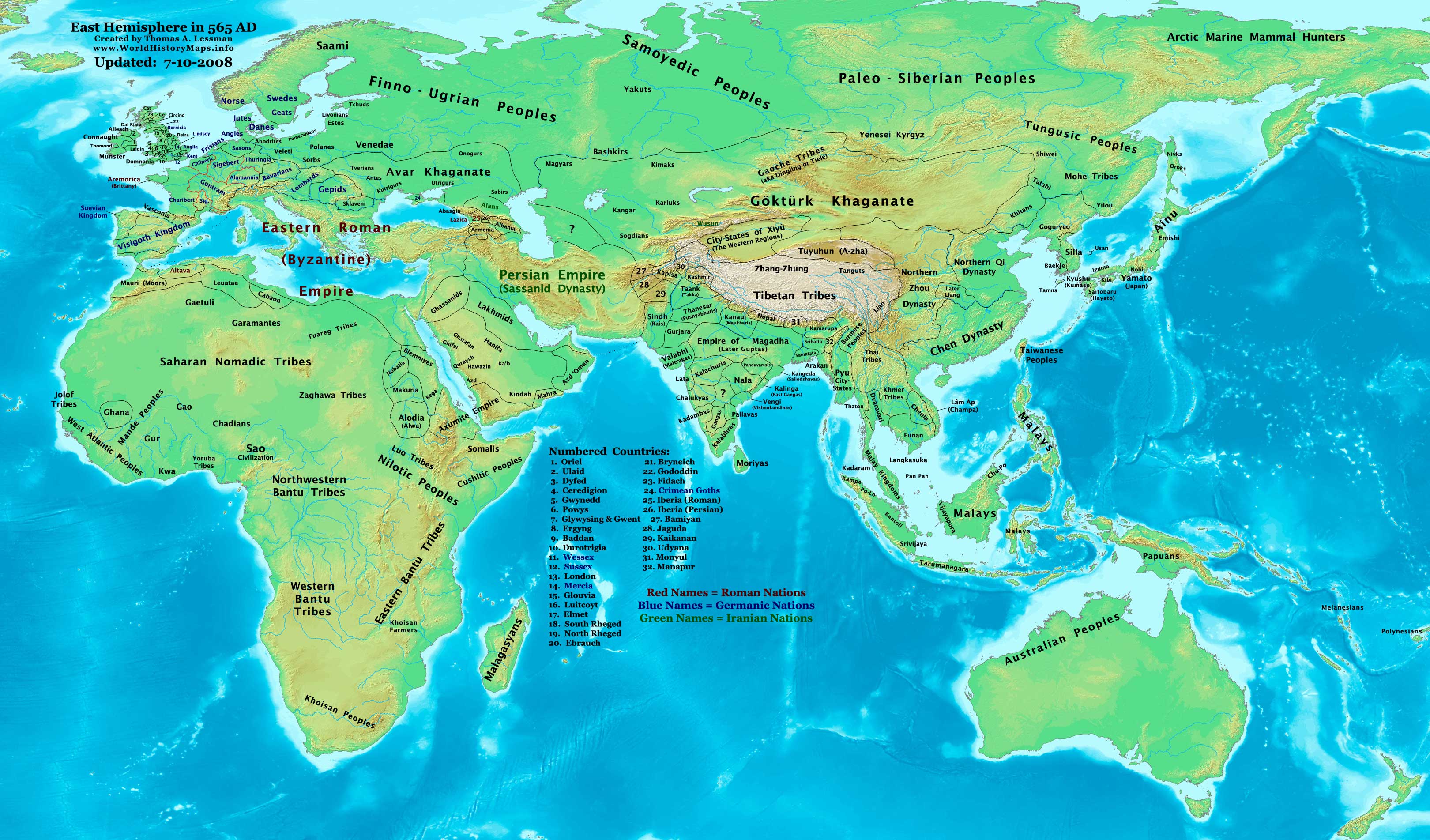
001 AD edit
Hello again. In this map File:Asia 001ad.jpg Shiwei ethnic group is shown along with Xianbei.
Shiwei descended from Xianbei so they cannot be shown at the same time. :) Gantuya eng (talk) 09:01, 1 September 2009 (UTC)
Byzantine Map edit
Hello. There's an ongoing discussion on Talk:Byzantine Empire about changing the map in the infobox, and since you were involved last time there was a major discussion about the map, I thought you might be interested.--Michael X the White (talk) 12:55, 23 September 2009 (UTC)
Your Maps edit
I have to say I love reading/looking at historic world maps and creating my own but I especially love yours. Keep up the maps because they're brilliant. Look forward to seeing more. Karlstar (talk) 20:44, 12 October 2009 (UTC)
HEY! edit
I know this is a very very late response (several years at least) but better late than never right? It's good to see another feverish map maker like myself. Keep up the good work! Since you had most of the world maps already done, i've moved on to making more detailed maps of specific regions. Anyways, good to see you are still at it. (Javierfv1212 (talk) 23:29, 21 March 2010 (UTC))
Map discussion edit
Hello!
I'd like to ask you the references of you "NE 200bc.jpg" map. there are 0 and so it is a violation of WP:V and is possibly WP:OR. Can you please reference it? Or maybe change in accordance to references. Regards Aregakn (talk) 06:36, 29 May 2010 (UTC)
Maps are gone... NOOOO! edit
I am a fan of your maps but your website is down, is it going back up? Do you have all you maps on wikipedia?--Ollyoxenfree (talk) 03:58, 3 January 2012 (UTC)
Please revise 200BC Map edit
I wanted to draw your attention to comments on the 200BC map over here. Thanks and keep up the good work. You may also be interested in similar concerns regarding the widely disseminated animated map of Chinese history linked from my user page... currently out of time but hoping to get some sort of team of people together to make a citation-capable Wiki-style GIS interface somehow possible. prat (talk) 02:23, 14 March 2012 (UTC)
Please revise 600BC Map edit
The correct spelling is Halstatt. Possibly misspelled on other maps (I didn't check further). Jllatimer (talk) —Preceding undated comment added 21:51, 26 August 2012 (UTC)
Upcoming Wikimedia events in Missouri and Kansas! edit
You're invited to 3 exciting events Wikipedians are planning in your region this June—a tour and meetup at the National Archives in Kansas City, and Wiknics in Wichita and St. Louis:
|
 |
|
And two local editions of the Great American Wiknic, the "picnic anyone can edit." Come meet (and geek out with, if you want) your local Wikipedians in a laid-back atmosphere:
|
|
Come to the First Topeka Meetup, January 15! edit

Come celebrate Wikipedia Day with other Kansas Wikipedians sponsored by Wikimedians Active in Local Regions in the United States (WALRUS) and hosted by the Topeka and Shawnee Public Library. Come chat, hang out and enjoy good company while find out more about Wikipedia in our regional community! RSVP at Wikipedia:Meetup/Topeka/Wikipedia_Day.
If you can't come, but still want to find out about events in the greater Topeka region (which may include KC, Manhattan, Lawrence, Salina, or other places where volunteers are interested) sign up for future notifications at Wikipedia:Meetup/Topeka/Invite list.
Hope to see you there Sadads (talk) 20:21, 18 December 2012 (UTC)
Links problem edit
Hi, I was looking over your user page, and saw a couple of problems: your first map link to "this blank map template" results in a 404 Not Found error, and the following map link, "this topographical map", links to the Wikipedia article on topographic maps, not to any map in particular. I am trying to get a handle on your map making resources, but links like these are not helping me. Do you think you could fix them/ make them more specific? Thanks! KDS4444Talk 03:26, 20 October 2014 (UTC)
Website www.WorldHistoryMaps.info edit
the website www.WorldHistoryMaps.info is no longer active. When trying to go to that site, either by using the link on the User:Talessman/Maps page or by typing it into a search engine, all you get is Go Daddy webpage saying "NOTICE: This domain name expired on 23/12/2014 and is pending renewal or deletion." Also saying "Welcome to: worldhistorymaps.info This Web page is parked for FREE, courtesy of GoDaddy.com." Scotius (talk) 12:53, 27 December 2014 (UTC)
Hi,
You appear to be eligible to vote in the current Arbitration Committee election. The Arbitration Committee is the panel of editors responsible for conducting the Wikipedia arbitration process. It has the authority to enact binding solutions for disputes between editors, primarily related to serious behavioural issues that the community has been unable to resolve. This includes the ability to impose site bans, topic bans, editing restrictions, and other measures needed to maintain our editing environment. The arbitration policy describes the Committee's roles and responsibilities in greater detail. If you wish to participate, you are welcome to review the candidates' statements and submit your choices on the voting page. For the Election committee, MediaWiki message delivery (talk) 13:00, 23 November 2015 (UTC)
Roman And Byzantine Military History edit
Hello I currently have a project known as the Roman and Byzantine military history page Wikipedia:WikiProject Military history/Incubator/Roman and Byzantine Military History, I was wondering if you would like to join, as you have shown interest in roman history. Iazyges (talk) 18:56, 15 August 2016 (UTC)

The file File:Roman-Empire 200bc sm.jpg has been proposed for deletion because of the following concern:
Orphaned map.
While all constructive contributions to Wikipedia are appreciated, pages may be deleted for any of several reasons.
You may prevent the proposed deletion by removing the {{proposed deletion/dated files}} notice, but please explain why in your edit summary or on the file's talk page.
Please consider addressing the issues raised. Removing {{proposed deletion/dated files}} will stop the proposed deletion process, but other deletion processes exist. In particular, the speedy deletion process can result in deletion without discussion, and files for discussion allows discussion to reach consensus for deletion. ~ Rob13Talk 17:55, 20 October 2018 (UTC)
Speedy deletion nomination of American Coalition for Fathers and Children edit

If this is the first article that you have created, you may want to read the guide to writing your first article.
You may want to consider using the Article Wizard to help you create articles.
A tag has been placed on American Coalition for Fathers and Children requesting that it be speedily deleted from Wikipedia. This has been done under section A7 of the criteria for speedy deletion, because the article appears to be about a company, corporation or organization that does not credibly indicate how or why the subject is important or significant: that is, why an article about that subject should be included in an encyclopedia. Under the criteria for speedy deletion, such articles may be deleted at any time. Please read more about what is generally accepted as notable.
If you think this page should not be deleted for this reason, you may contest the nomination by visiting the page and clicking the button labelled "Contest this speedy deletion". This will give you the opportunity to explain why you believe the page should not be deleted. However, be aware that once a page is tagged for speedy deletion, it may be deleted without delay. Please do not remove the speedy deletion tag from the page yourself, but do not hesitate to add information in line with Wikipedia's policies and guidelines. If the page is deleted, and you wish to retrieve the deleted material for future reference or improvement, then please contact the deleting administrator. DGG ( talk ) 18:33, 25 July 2019 (UTC)