Urmond is a village in the Dutch province of Limburg. It is located in the municipality of Stein.
Urmond | |
|---|---|
Village | |
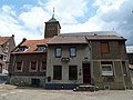
 Centre of Urmond | |
 Flag | |
 Urmond Location in the Netherlands  Urmond Location in the province of Limburg in the Netherlands | |
| Coordinates: 50°59′26″N 5°46′16″E / 50.99056°N 5.77111°E | |
| Country | Netherlands |
| Province | Limburg |
| Municipality | Stein |
| Area | |
| • Total | 2.87 km2 (1.11 sq mi) |
| Elevation | 46 m (151 ft) |
| Population (2021)[1] | |
| • Total | 3,555 |
| • Density | 1,200/km2 (3,200/sq mi) |
| Time zone | UTC+1 (CET) |
| • Summer (DST) | UTC+2 (CEST) |
| Postal code | 6129[1] |
| Dialing code | 046 |
The village was first mentioned in 1153 as Ouermunte. The current name means "mouth of the Ur", however the Ur has later moved to village.[3] Urmond developed on the higher bank of the Maas. In 1400, it became part of the Duchy of Jülich.[4]
The Old St Martinus Church was built between 1791 and 1793. The medieval tower was placed in 1841. The cemetery is artificially heightened.[4] In 1695, a Dutch Reformed church was built in Urmond which is exceptional in Limburg.[5]
Urmond was home to 600 people in 1840.[5] Urmond was a separate municipality until 1982, when it was merged with Stein.[6]
Gallery edit
-
 Apartment buildings
 -
 Former town hall
 -
 Street view
 -
 Terp Church
.jpg)


.JPG)
References edit
- ^ a b c "Kerncijfers wijken en buurten 2021". Central Bureau of Statistics. Retrieved 26 April 2022.
two entries
- ^ "Postcodetool for 6129AA". Actueel Hoogtebestand Nederland (in Dutch). Het Waterschapshuis. Retrieved 26 April 2022.
- ^ "Urmond - (geografische naam)". Etymologiebank (in Dutch). Retrieved 26 April 2022.
- ^ a b Sabine Broekhoven, & Ronald Stenvert (2003). Urmond (in Dutch). Zwolle: Waanders. ISBN 90 400 9623 6. Retrieved 26 April 2022.
- ^ a b "Urmond". Plaatsengids (in Dutch). Retrieved 26 April 2022.
- ^ Ad van der Meer and Onno Boonstra, Repertorium van Nederlandse gemeenten, KNAW, 2011.
This Dutch Limburg location article is a stub. You can help Wikipedia by expanding it. |