Trump Street is a street in the City of London that was originally known as Trumpadere Street, probably after the trumpet or horn makers who once worked there or in the adjacent Trump Alley (now demolished). It was built after the Great Fire of London (1666) but completely destroyed by bombing during the Second World War and has since been entirely rebuilt.

Location edit

Trump Street runs between Russia Row and King Street.[1] The pedestrianised Honey Lane runs from the south side to join it to Cheapside. It is crossed only by Lawrence Lane.[2]

Freeman's Court, originally known as Trump Alley, once ran between Lawrence Lane and Honey Lane immediately to the south of and parallel with Trump Street.[3]
Origins edit
Trump Street, originally known as Trumpadere Street,[4] was built after the Great Fire of London in 1666. John Strype called it Duke Street in 1720.[5]
The street may be named after Trump Alley[6] or named because its occupants had the same occupation as those that lived in the alley. Henry Riley writes in his Memorials of the inscription on the coffin of Godefrey le Trompour and of trumpeters generally that:
The persons who followed this trade mostly lived, in all probability, in Trump Street, formerly Trump Alley (a much longer street then than it now is), near the Guildhall; their principal customers not improbably being the City waits, or watchmen; each of whom was provided with a trumpet, also known as a "wait," for sounding the hours of the watch, and giving the alarm. In reference to this trade it deserves remark, that the only memorial that has come down to us of the Chapel of St. Mary the Virgin, and of St. Mary Magdalen and All Saints, formerly adjoining the Guildhall, is a massive stone coffin (now in the Library at Guildhall), with its lid, whereon is sculptured a cross between two trumpets, and around its margin the following inscription:-Godefrey le Trompour : gist : ci : Deu : del : ealme : eit : merci. "Godefrey the Trompour lies here, God on the soul have mercy." In Trump Alley, close adjoining, he probably lived, sold trumpets, and died;—if we may judge from the character of the writing, in the latter half of the 14th century.[7]
Henry Harben considered that Riley was wrong to believe that Trump Alley and Trump Street were synonymous.[6]
Trump Street was recorded by the cartographer John Rocque in 1746,[6] and The London Encyclopaedia write that it "probably derived from a nearby Tavern, the Trumpeter Inn".[8] It appears on Richard Horwood's original (1799) and revised (1813) map of London with Honey Lane Market at its western end where Russia Row is now.[9]
Buildings edit
A tavern known as Blossom's Inn once stood on the north side of the street on a large site on the corner with Lawrence Lane from the fourteenth century until 1855. In the 1750s it became the London base for James Pickford, founder of the Pickfords removal firm. Archaeological excavations on the site in 2001 recovered Roman remains.[10] The site became a parcels depot for the Great Eastern Railway in the nineteenth century before being renamed Blossom's Inn again in the twentieth century.[2]
The street was completely destroyed by German bombing on 29 December 1940 during the Second World War and has since been rebuilt.[4]
.jpg)
Today it is completely made up of office buildings with some retail premises at street level. The City Tavern, a post-Second World War pub which once stood on the south side on the corner with Lawrence Lane has been replaced with offices. Opposite, still on the south side, is King's House (36–37 King Street). The north side, east of Lawrence Lane, is 35 King Street.[2] The north side west of Lawrence Lane is an office building of 386,000 square feet (35,900 m2)[11] known as 30 Gresham Street that was developed by Land Securities in 2002–2003 and was described at the time as "the biggest speculative office development in the capital".[12]
Gallery edit
-
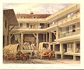 Blossom's Inn, Thomas H. Shepherd, 1850
 -
![Trump Street on a 1916 Ordnance Survey map[13]](//upload.wikimedia.org/wikipedia/commons/thumb/d/d9/Russia_Row_and_Trump_Street_1910s_Ordnance_Survey_map.jpg/120px-Russia_Row_and_Trump_Street_1910s_Ordnance_Survey_map.jpg) Trump Street on a 1916 Ordnance Survey map[13]
Trump Street on a 1916 Ordnance Survey map[13] -
![London Blitz bomb damage map, c. 1945. Purple = damaged beyond repair. Scarlet = seriously damaged, doubtful if repairable. Other colours = lower levels of damage.[14]](//upload.wikimedia.org/wikipedia/commons/thumb/c/c6/City_of_London_Bomb_Damage_Map_Trump_Street_%26_Russia_Row.jpg/120px-City_of_London_Bomb_Damage_Map_Trump_Street_%26_Russia_Row.jpg) London Blitz bomb damage map, c. 1945. Purple = damaged beyond repair. Scarlet = seriously damaged, doubtful if repairable. Other colours = lower levels of damage.[14]
London Blitz bomb damage map, c. 1945. Purple = damaged beyond repair. Scarlet = seriously damaged, doubtful if repairable. Other colours = lower levels of damage.[14]

![Trump Street on a 1916 Ordnance Survey map[13]](/wiki/File:Russia_Row_and_Trump_Street_1910s_Ordnance_Survey_map.jpg)
![London Blitz bomb damage map, c. 1945. Purple = damaged beyond repair. Scarlet = seriously damaged, doubtful if repairable. Other colours = lower levels of damage.[14]](/wiki/File:City_of_London_Bomb_Damage_Map_Trump_Street_%26_Russia_Row.jpg)
References edit
- ^ Philip's Street Atlas London, Philips, London, 2003. p. 242. ISBN 0540084654
- ^ a b c Multiple Ordnance Survey maps, Digimap. Retrieved 6 January 2018. (subscription required)
- ^ Foxton Inn – Fresh Wharf Gateway. British History Online. Retrieved 7 January 2018.
- ^ a b Smith, Al. (1970) Dictionary of City of London Street Names. Newton Abbot: David & Charles. p. 203. ISBN 0715348809
- ^ Besant, Walter. (1910) London City. (The Survey of London) London: Adam & Charles Black. p. 37.
- ^ a b c "Trump Alley – Turners' Alley – British History Online". www.british-history.ac.uk. Retrieved 6 January 2018.
- ^ Riley, Henry Thomas. (1868) Memorials of London and London Life, in the XIIIth, XIVth, and XVth Centuries. London: Longmans, Green, & Co. pp. xxi–xxii.
- ^ "Trump Street" in Christopher Hibbert; Ben Weinreb; John Keay; Julia Keay (2008). The London Encyclopaedia (3rd ed.). London: Pan Macmillan. p. 948. ISBN 978-0-230-73878-2.
- ^ Laxton, Paul & Joseph Wisdom. (1985) The A to Z of Regency London. London: London Topographical Society. p. 31. ISBN 0902087193
- ^ "Lawrence Lane", The London Encyclopaedia, p. 476.
- ^ "Buildings going up despite City glut", Jenny Davey, The Times, 20 October 2003, p. 25.
- ^ "Gamble on Gresham St." The Times, 22 May 2003, p. 35.
- ^ Ordnance Survey map of London, 1916, 2nd revision. Digimap. Retrieved 10 January 2018. (subscription required)
- ^ The meticulously hand-coloured bomb damage maps of London – in pictures. The Guardian, 2 September 2015. Retrieved 2 February 2018.
External links edit
 Media related to Trump Street, London at Wikimedia Commons