Tropical Storm Barijat, known in the Philippines as Tropical Storm Neneng, was a weak tropical storm that caused flooding in the far northern regions of the Philippines and Southern China. Barijat, a replacement name for Utor which is a Marshallese word for coastal areas impacted by waves or winds, the thirty-third tropical depression and twenty-third tropical storm of the 2018 Pacific typhoon season, it was first noted as an area of convection in the South China Sea on September 6. On September 8, it was upgraded to a tropical depression, and by September 11, it intensified into a tropical storm, with the Japan Meteorological Agency (JMA) giving it the name Barijat. Barijat peaked in intensity 6 hours later, with 10-min winds of 40 knots (75 km/h; 45 mph) and 1-min winds of 45 knots (85 km/h; 50 mph). Barijat continued westward, and on November 12 at 00:30 UTC, it made landfall over Zhanjiang, quickly dissipating afterwards.
 Barijat at peak intensity in the South China Sea on September 11 | |
| Meteorological history | |
|---|---|
| Formed | September 8, 2018 |
| Dissipated | September 13, 2018 |
| Tropical storm | |
| 10-minute sustained (JMA) | |
| Highest winds | 75 km/h (45 mph) |
| Lowest pressure | 998 hPa (mbar); 29.47 inHg |
| Tropical storm | |
| 1-minute sustained (SSHWS/JTWC) | |
| Highest winds | 85 km/h (50 mph) |
| Lowest pressure | 996 hPa (mbar); 29.41 inHg |
| Overall effects | |
| Fatalities | None |
| Damage | $7.3 million |
| Areas affected | Philippines, Taiwan, South China, Vietnam |
| IBTrACS | |
Part of the 2018 Pacific typhoon season | |
Meteorological history edit

Tropical storm (39–73 mph, 63–118 km/h)
Category 1 (74–95 mph, 119–153 km/h)
Category 2 (96–110 mph, 154–177 km/h)
Category 3 (111–129 mph, 178–208 km/h)
Category 4 (130–156 mph, 209–251 km/h)
Category 5 (≥157 mph, ≥252 km/h)
Unknown
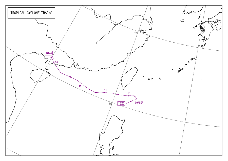
On September 6 at 06:00 UTC, the Joint Typhoon Warning Center (JTWC) began monitoring an area of convection approximately 140 nautical miles (260 km; 160 mi) southwest of Manila, assessing its development potential as low.[1] The next day at 20:00 UTC, its development potential was upgraded to medium as it continued northeastward, with satellite imagery depicting a partially exposed low-level circulation.[2] The system continued northeastwards, and on September 8 at 06:00 UTC, both the JMA and the PAGASA assessed that the system had developed into a tropical depression,[3] with the PAGASA assigning it the local name Neneng as the system was located inside the agency's area of responsibility.[4] Later that day at 19:30 UTC, the JTWC issued a Tropical Cyclone Formation Alert for the system,[5] and on September 9 at 06:00 UTC, the JTWC upgraded the system to a tropical depression, giving it the designation 27W,[6] after which the system abruptly turned westward over the Bashi Channel.[4] Infrared satellite imagery at 21:00 UTC showed a partially-exposed circulation center with deep convection over the southern portion of the storm.[7]
The depression continued westward, being steered by a low to mid-level subtropical ridge, and on September 10 at 06:00 UTC, the JTWC upgraded 27W to a tropical storm as it was located approximately 80 nautical miles (150 km; 90 mi) south-southeast of Kaohsiung.[6][8] 27W was located in a favorable environment with high sea surface temperatures,[9] with infrared satellite imagery showing a small storm and flaring convection obscuring its circulation.[10] 27W left the PAGASA's area of responsibility at 14:00 UTC,[4] and on September 11 at 00:00 UTC, the JMA upgraded the depression to a tropical storm, assigning it the name Barijat.[3] Hours later at 06:00 UTC, both the JMA and the JTWC assessed Barijat to have peaked, with the JMA estimating 10-minute sustained winds of 75 km/h (45 mph)[3] and the JTWC estimating 1-minute sustained winds of 85 km/h (50 mph).[6] Barijat continued westward under marginally favorable conditions,[11] before weakening slightly the next day.[6] Enhanced infrared satellite imagery showed that Barijat's circulation became partially exposed,[12] and on September 12 at 00:30 UTC, Barijat made landfall over Zhanjiang,[13] with satellite imagery showing weak convection being sheared, completely exposing the circulation center.[14] On the next day at 06:00 UTC, both the JMA and the JTWC downgraded Barijat to a tropical depression, with the JTWC downgrading Barijat to a tropical disturbance and the JMA assessing Barijat to have dissipated 6 hours later.[3][6]
Preparations and impact edit
Philippines edit
Barijat's precursor brought rains over northern Luzon, enhancing the southwest monsoon in the process.[15] It also brought gusty winds and heavy rains to the province of Batanes and to the Babuyan Islands, with the PAGASA raising Tropical Cyclone Wind Signal No. #1 over Batanes. The PAGASA advised residents living in the affected areas to take precautions against flooding and landslides,[16] with fishermen and other people with small vessels being advised against sailing in the area.[17] Barijat caused several landslides in Batanes, with floods entering schools and creeks overflowing.[18] Barijat brought increased risk of flooding and landslides in the provinces of Batanes, Cagayan, and Isabela, with the soil saturation worsening the effects of Typhoon Mangkhut.[19]
China edit
The weather bureau of Hainan issued an alert against strong gales and downpours.[20] 40 thousand residents were evacuated in the cities of Zhanjiang and Maoming,[21] with passenger and train services being halted due to safety concerns.[22] 11 thousand fishermen, 32 thousand offshore workers, and 36 thousand boats were brought back to land.[23] In Macau, there was no significant disruption to the city's activities.[24] Damages in China were estimated at ¥50 million (US$7.3 million).[25]
Vietnam edit
The northern parts of Vietnam were warned of possible flash flooding.[26]
See also edit
References edit
- ^ "Significant Tropical Weather Advisory for the Western and South Pacific Oceans from 060600Z-070600Z September 2018". Joint Typhoon Warning Center. September 6, 2018. Archived from the original on July 10, 2018. Retrieved March 20, 2021.
- ^ "Significant Tropical Weather Advisory for the Western and South Pacific Oceans Reissued from 072000Z-080600Z September 2018". Joint Typhoon Warning Center. September 7, 2018. Archived from the original on July 10, 2018. Retrieved March 20, 2021.
- ^ a b c d Annual Report on the Activities of the RSMC Tokyo - Typhoon Center 2018 (PDF) (Report). December 26, 2019. p. 48. Retrieved March 23, 2021.
- ^ a b c Duran, Samuel F.; Galang, Juanito S.; Gile, Robb P.; Reyes, Sheilla Mae R.; Tolentino, Jerome T. (June 2021). DOST-PAGASA Annual Report on Philippine Tropical Cyclones (Report). Quezon City, Philippines: PAGASA. pp. 91–94. ISSN 2672-3190. Retrieved July 7, 2021.
- ^ "WTPN21 PGTW 081930". Joint Typhoon Warning Center. September 8, 2018. Archived from the original on July 10, 2018. Retrieved March 20, 2021.
- ^ a b c d e "2018 Western North Pacific Ocean Best Track Data". Joint Typhoon Warning Center. Retrieved March 23, 2021.
- ^ "Prognostic Reasoning for Tropical Depression 27W (Twentyseven) Warning NR 01". Joint Typhoon Warning Center. September 9, 2018. Archived from the original on September 9, 2018. Retrieved March 20, 2021.
- ^ "Prognostic Reasoning for Tropical Storm 27W (Twentyseven) Warning NR 03". Joint Typhoon Warning Center. September 10, 2018. Archived from the original on September 10, 2018. Retrieved March 21, 2021.
- ^ "RSMC Tropical Cyclone Prognostic Reasoning No. 4 for TD Located at 21.1N 119.5E". Japan Meteorological Agency. September 10, 2018. Archived from the original on August 19, 2018. Retrieved March 31, 2021.
- ^ "Prognostic Reasoning for Tropical Storm 27W (Twentyseven) Warning NR 05". Joint Typhoon Warning Center. September 10, 2018. Archived from the original on September 10, 2018. Retrieved March 21, 2021.
- ^ "Prognostic Reasoning for Tropical Storm 27W (Barijat) Warning NR 07". Joint Typhoon Warning Center. September 11, 2018. Archived from the original on July 9, 2018. Retrieved March 23, 2021.
- ^ "Prognostic Reasoning for Tropical Storm 27W (Barijat) Warning NR 13". Joint Typhoon Warning Center. September 12, 2018. Archived from the original on July 9, 2018. Retrieved March 31, 2021.
- ^ "The 23th typhoon Barijat made landfall along coast of Zhanjiang City, Guangdong Province". China Meteorological Administration. September 13, 2018. Retrieved March 23, 2021.
- ^ "Prognostic Reasoning for Tropical Depression 27W (Barijat) Warning NR 15". Joint Typhoon Warning Center. September 13, 2018. Archived from the original on July 9, 2018. Retrieved March 31, 2021.
- ^ "LPA, southwest monsoon affecting Northern Luzon". Rappler. September 8, 2018. Retrieved March 23, 2021.
- ^ "'Neneng' threatens northern Luzon; another typhoon nears PH". ABS-CBN News and Current Affairs. September 10, 2018. Retrieved March 21, 2021.
- ^ "Batanes still under Signal No. 1 due to Neneng". Rappler. September 10, 2018. Retrieved March 23, 2021.
- ^ "Neneng, nagdulot ng pinsala sa Batanes". ABS-CBN News and Current Affairs (in Tagalog). September 11, 2018. Retrieved March 21, 2021.
- ^ "Philippines: Action Against Hunger Prepared for Typhoon Mangkhut". Action Against Hunger. September 13, 2018. Retrieved March 21, 2021.
- ^ "South China braces for Typhoon Barijat". China News Service. September 11, 2018. Retrieved March 28, 2021.
- ^ "Typhoon Barijat makes landfall in Guangdong". The Standard. September 13, 2018. Retrieved March 28, 2021.
- ^ "Typhoon Barijat disrupts traffic in Hainan". China News Service. September 12, 2018. Retrieved March 28, 2021.
- ^ "12,000 residents evacuated as typhoon Barijat approaches Guangdong". Xinhua News Agency. September 13, 2018. Archived from the original on September 13, 2018. Retrieved January 14, 2022.
- ^ Marques, Renato (September 13, 2018). "Typhoon Barijat passes with whimper, Mangkhut expected to thunder". Macau Daily Times. Retrieved March 23, 2021.
- ^ Member Report: China (PDF). ESCAP/WMO Typhoon Committee. December 4, 2018. pp. 1–2. Archived from the original (PDF) on December 4, 2018. Retrieved December 4, 2018.
- ^ "Tropical storm Barijat and Typhoon Mangkhut to affect Thailand next week". National News Bureau of Thailand. September 13, 2018. Retrieved January 14, 2022 – via ReliefWeb.
External links edit
- 27W.BARIJAT from the U.S. Naval Research Laboratory
- General Information of Tropical Storm Barijat (1823) from Digital Typhoon
- JMA Best Track Data of Tropical Storm Barijat (1823) (in Japanese)
- JMA Best Track (Graphics) of Tropical Storm Barijat (1823)