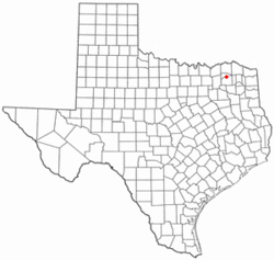
Tira is a town in Hopkins County, Texas, United States. The population was 297 at the 2010 census.[5]
Tira, Texas | |
|---|---|
 Location of Tira, Texas | |
 | |
| Coordinates: 33°19′36″N 95°34′11″W / 33.32667°N 95.56972°W | |
| Country | United States |
| State | Texas |
| County | Hopkins |
| Area | |
| • Total | 1.44 sq mi (3.73 km2) |
| • Land | 1.42 sq mi (3.67 km2) |
| • Water | 0.02 sq mi (0.06 km2) |
| Elevation | 469 ft (143 m) |
| Population (2010) | |
| • Total | 297 |
| • Estimate (2019)[3] | 313 |
| • Density | 220.73/sq mi (85.23/km2) |
| Time zone | UTC-6 (Central (CST)) |
| • Summer (DST) | UTC-5 (CDT) |
| ZIP code | 75482 |
| FIPS code | 48-73124[4] |
| GNIS feature ID | 1380666[2] |
Geography edit
Tira is located in northern Hopkins County at 33°19′36″N 95°34′11″W / 33.32667°N 95.56972°W (33.326629, –95.569853).[6] Texas State Highway 19 runs through the western part of the town, leading north 25 miles (40 km) to Paris and south 13 miles (21 km) to Sulphur Springs, the Hopkins county seat. Tira is 1 mile (1.6 km) east of the dam at the outlet of Jim Chapman Lake (formerly known as Cooper Lake) and is 9 miles (14 km) by road northeast of the South Sulphur Unit of Cooper Lake State Park.
According to the United States Census Bureau, the town has a total area of 1.4 square miles (3.7 km2), of which 0.02 square miles (0.06 km2), or 1.65%, are water.[5]
Demographics edit
| Census | Pop. | Note | %± |
|---|---|---|---|
| 1980 | 249 | — | |
| 1990 | 237 | −4.8% | |
| 2000 | 248 | 4.6% | |
| 2010 | 297 | 19.8% | |
| 2019 (est.) | 313 | [3] | 5.4% |
| U.S. Decennial Census[7] | |||
| Race | Number | Percentage |
|---|---|---|
| White (NH) | 274 | 85.89% |
| Black or African American (NH) | 9 | 2.82% |
| Native American or Alaska Native (NH) | 2 | 0.63% |
| Asian (NH) | 1 | 0.31% |
| Mixed/Multi-Racial (NH) | 10 | 3.13% |
| Hispanic or Latino | 23 | 7.21% |
| Total | 319 |
As of the 2020 United States census, there were 319 people, 115 households, and 80 families residing in the town.
Education edit
Tira is served by the North Hopkins Independent School District.
References edit
- ^ "2019 U.S. Gazetteer Files". United States Census Bureau. Retrieved August 7, 2020.
- ^ a b U.S. Geological Survey Geographic Names Information System: Tira, Texas
- ^ a b "Population and Housing Unit Estimates". United States Census Bureau. May 24, 2020. Retrieved May 27, 2020.
- ^ "U.S. Census website". United States Census Bureau. Retrieved January 31, 2008.
- ^ a b "Geographic Identifiers: 2010 Census Summary File 1 (G001): Tira town, Texas". American Factfinder. U.S. Census Bureau. Archived from the original on February 13, 2020. Retrieved March 15, 2018.
- ^ "US Gazetteer files: 2010, 2000, and 1990". United States Census Bureau. February 12, 2011. Retrieved April 23, 2011.
- ^ "Census of Population and Housing". Census.gov. Retrieved June 4, 2015.
- ^ "Explore Census Data". data.census.gov. Retrieved May 22, 2022.
- ^ https://www.census.gov/ [not specific enough to verify]
- ^ "About the Hispanic Population and its Origin". www.census.gov. Retrieved May 18, 2022.