List of state highway loops in Texas (500–9999)
State highway loops in Texas are owned and maintained by the Texas Department of Transportation (TxDOT).
Texas State Highway Loop marker | |
| Highway names | |
|---|---|
| Interstates | Interstate Highway X (IH-X, I-X) |
| US Highways | U.S. Highway X (US X) |
| State | State Highway X (SH X) |
| Loops: | Loop X |
| Spurs: | Spur X |
| Farm or Ranch to Market Roads: | Farm to Market Road X (FM X) Ranch-to-Market Road X (RM X) |
| Park Roads: | Park Road X (PR X) |
| System links | |
Loop 500 edit
State Highway Loop 500 | |
|---|---|
| Location | Shelby County |
| Length | 1.021 mi[1] (1.643 km) |
| Existed | April 29, 1971–present |
Loop 500 is located in Shelby County. It runs from US 96 northwest of Center to SH 7 southwest of Center.
Loop 500 was designated on April 29, 1971, as a loop off SH 7 in Center. On August 26, 2010, the northern section was extended west 2.9 miles (4.7 km) to US 96 northwest of Center.
Loop 505 edit
State Highway Loop 505 | |
|---|---|
| Location | Newton County |
| Length | 3.654 mi[2] (5.881 km) |
| Existed | August 31, 1972–present |
Loop 505 is located in Newton County. It runs from SH 87 northeast of Newton to SH 87 southwest of Newton.
Loop 505 was designated on August 31, 1972, on the current route along an old routing of SH 87; the route was signed as SH 87 Business rather than Loop 505.
Loop 506 edit
State Highway Loop 506 | |
|---|---|
| Location | Wise County |
| Existed | May 31, 1972[3]–June 21, 1990 |
Loop 506 was located in Wise County. It is now Bus. US 81.
Loop 507 edit
State Highway Loop 507 | |
|---|---|
| Location | Brazos County |
| Existed | August 31, 1972[4]–June 21, 1990 |
Loop 507 was designated on August 31, 1972, as a loop off SH 6 in Bryan-College Station. The route was signed as SH 6 Business rather than Loop 507. On June 21, 1990, Loop 507 was cancelled and transferred to Bus. SH 6.
Loop 508 edit
State Highway Loop 508 | |
|---|---|
| Location | Grimes County |
| Existed | August 31, 1972[5]–June 21, 1990 |
Loop 508 was designated on August 31, 1972, as a loop off SH 6 in Navasota. The route was signed as SH 6 Business rather than Loop 508. On June 21, 1990, Loop 508 was cancelled and transferred to Bus. SH 6.
Loop 509 edit
State Highway Loop 509 | |
|---|---|
| Location | Collin County |
| Existed | July 31, 1972[6]–June 21, 1990 |
Loop 509 was designated on July 31, 1972, as a loop off SH 78 in Copeville along an old routing of SH 78. on June 21, 1990, Loop 509 was cancelled and transferred to Bus. SH 78.
Loop 512 edit
State Highway Loop 512 | |
|---|---|
| Location | Montgomery County |
| Existed | November 3, 1972[7]–June 21, 1990 |
Loop 512 was designated on November 3, 1972, as a loop off US 59 in Splendora along an old routing of US 59. The route was signed as US 59 Business rather than Loop 512. On June 21, 1990, Loop 512 was cancelled and transferred to Bus. US 59.
Loop 513 edit
State Highway Loop 513 | |
|---|---|
| Location | Guadalupe County |
| Existed | September 4, 1973[8]–June 21, 1990 |
Loop 513 was designated on September 4, 1973, as a loop off SH 123 in Seguin along an old routing of SH 123. The route was signed as SH 123 Business rather than Loop 513. On June 21, 1990, Loop 513 was cancelled and transferred to Bus. SH 123.
Loop 516 edit
State Highway Loop 516 | |
|---|---|
| Location | Bee County |
| Existed | May 31, 1973[9]–June 21, 1990 |
Loop 516 was designated on May 31, 1973, as a loop off US 181 in Beeville along an old routing of US 181. The route was signed as US 181 Business rather than Loop 516. On June 21, 1990, Loop 516 was cancelled and transferred to Bus. US 181.
Loop 517 edit
State Highway Loop 517 | |
|---|---|
| Location | Dimmit County |
| Length | 2.694 mi[10] (4.336 km) |
| Existed | June 20, 1975–present |
Loop 517 is located in Dimmit County. It runs from US 83 northeast of Carrizo Springs to US 277 northwest of Carrizo Springs.
Loop 517 was designated on June 20, 1975, on the current route.
Loop 518 edit
State Highway Loop 518 | |
|---|---|
| Location | Bell County |
| Existed | November 25, 1975–June 21, 1990[11] |
Loop 518 was designated on November 25, 1975, as a loop off US 190 in Killeen along an old routing of US 190. The route was signed as US 190 Business instead of Loop 518. On June 21, 1990, Loop 518 was cancelled and transferred to Bus. US 190.
Loop 519 edit
State Highway Loop 519 | |
|---|---|
| Location | Culberson County |
| Existed | November 25, 1975–June 21, 1990[12] |
Loop 519 was located in Culberson County. It was the former alignment of US 80 through Van Horn. It is now Business I-10.
Loop 520 edit
State Highway Loop 520 | |
|---|---|
| Location | Hill County |
| Existed | November 25, 1975–June 21, 1990[13] |
Loop 520 was designated on November 25, 1975, as a loop off SH 171 in Covington along an old routing of SH 171. On June 21, 1990, Loop 520 was cancelled and transferred to Bus. SH 171.
Loop 521 edit
State Highway Loop 521 | |
|---|---|
| Location | Jackson County |
| Length | 3.442 mi[14] (5.539 km) |
| Existed | June 30, 1976–present |
Loop 521 is located in Jackson County. It runs from US 59 east of Edna to US 59 west of Edna.
Loop 521 was designated on June 30, 1976, on the current route along an old routing of US 59.
Loop 522 edit
State Highway Loop 522 | |
|---|---|
| Location | Jackson County |
| Length | 2.571 mi[15] (4.138 km) |
| Existed | June 30, 1976–present |
Loop 522 is located in Jackson County. It runs from US 59 east of Ganado to US 59 west of Ganado.
Loop 522 was designated on June 30, 1976, on the current route along an old routing of US 59; the route was signed as US 59 Business rather than Loop 522.
Loop 523 edit
State Highway Loop 523 | |
|---|---|
| Location | Wharton County |
| Length | 3.006 mi[16] (4.838 km) |
| Existed | June 21, 1979–present |
Loop 523 is located in Wharton County. It runs from US 59, 1.3 miles (2.1 km) west of Louise to US 59, 1.8 miles (2.9 km) east of Louise.
Loop 523 was designated on June 21, 1979, on the current route.
Loop 524 edit
State Highway Loop 524 | |
|---|---|
| Location | Wharton County |
| Length | 1.372 mi[17] (2.208 km) |
| Existed | June 30, 1976–present |
Loop 524 is located in Wharton County. It runs from US 59 east of Hillje to US 59 west of Hillje.
Loop 524 was designated on June 30, 1976, on the current route along an old routing of US 59; the route was signed as US 59 Business rather than Loop 524.
Loop 525 edit
State Highway Loop 525 | |
|---|---|
| Location | Wharton County |
| Existed | June 30, 1976–April 23, 1997[18] |
Loop 525 was designated on August 23, 1976, as a loop off US 59 in El Campo along an old routing of US 59. The route was signed as US 59 Business rather than Loop 525. On April 23, 1997, Spur 525 was cancelled and transferred to Bus. US 59.
Loop 526 edit
State Highway Loop 526 | |
|---|---|
| Location | Wharton County |
| Length | 1.439 mi[19] (2.316 km) |
| Existed | June 30, 1976–present |
Loop 526 is located in Wharton County. It runs from US 59 east of Pierce to US 59 west of Pierce.
Loop 526 was designated on June 30, 1976, on the current route along an old routing of US 59.
Loop 528 edit
State Highway Loop 528 | |
|---|---|
| Location | Ellis County |
| Existed | August 23, 1976–June 21, 1990[20] |
Loop 528 was designated on August 23, 1976, as a loop off US 287 in Waxahachie along an old routing of US 287. The route was signed as US 287 Business rather than Loop 528. On June 21, 1990, Loop 528 was cancelled and transferred to Bus. US 287.
Loop 530 edit
State Highway Loop 530 | |
|---|---|
| Location | Bell County |
| Existed | November 23, 1976–October 26, 2000[21] |
Loop 530 was designated on November 23, 1976, as a loop off US 190 in Belton along an old routing of US 190. On October 26, 2000, by district request, Loop 530 was cancelled and removed from the highway system due to the city of Belton planning utility improvements along the route.
Loop 531 edit
State Highway Loop 531 | |
|---|---|
| Location | Houston County |
| Existed | January 20, 1977–July 31, 2003[22] |
Loop 531 was located in Grapeland. It is now Bus. US 287.
Loop 532 edit
State Highway Loop 532 | |
|---|---|
| Location | La Salle and Webb counties |
| Existed | January 20, 1977[23]–June 21, 1990 |
Loop 532 was located in Encinal. It is now Business I-35.
Loop 533 edit
State Highway Loop 533 | |
|---|---|
| Location | Palo Pinto County |
| Length | 1.045 mi[24] (1.682 km) |
| Existed | May 27, 1977–present |
Loop 533 is located in Palo Pinto County. Both of its termini are at SH 16.
Loop 533 was designated on May 27, 1977, on the current route along an old routing of SH 16.
Loop 534 edit
State Highway Loop 534 | |
|---|---|
| Location | Kerr County |
| Length | 4.968 mi[25] (7.995 km) |
| Existed | May 2, 1977–present |
Loop 534, also known as Veterans Highway, is located in Kerr County. It runs 4.968 miles (7.995 km) from SH 173 south of Kerrville north to I-10.[25]
Loop 534 was designated on May 2, 1977, from FM 689 (now SH 173) southeast of Kerrville north to I-10. On October 23, 1978, the road was extended southeast 2.1 miles (3.4 km) to SH 16, replacing a section of FM 689 (although this section was signed as SH 173). On October 2, 1990, a 2-mile (3.2 km) section from SH 16 to the southern terminus was transferred to SH 173.[25]
- Junction list
The entire highway is in Kerrville, Kerr County.
| mi[26] | km | Destinations | Notes | ||
|---|---|---|---|---|---|
| 0.0 | 0.0 | Southern terminus | |||
| 0.2 | 0.32 | Bridge over the Guadalupe River | |||
| 0.4 | 0.64 | Access to Kerrville Municipal Airport | |||
| 3.2 | 5.1 | ||||
| 4.3 | 6.9 | ||||
| 4.9 | 7.9 | Leslie Drive | Northern terminus | ||
| 1.000 mi = 1.609 km; 1.000 km = 0.621 mi | |||||
Loop 538 edit
State Highway Loop 538 | |
|---|---|
| Location | Bexar and Guadalupe counties |
| Existed | January 24, 1978[27]–June 18, 1996 |
Loop 538 was designated on January 24, 1978, from FM 78, 0.5 miles (0.80 km) east of SH 218, east and northeast to FM 78 near Live Oak Road (now Schertz Parkway) in Schertz. The route was never built, and was cancelled on June 18, 1996.
Loop 539 edit
State Highway Loop 539 | |
|---|---|
| Location | Guadalupe County |
| Existed | January 24, 1978[28]–November 20, 2014 |
Loop 539 was designated on January 24, 1978, from FM 78, 0.3 miles (0.48 km) west of FM 1103, east and northeast to FM 78 near Haeckerville Road in Cibolo. On September 26, 1996, the road was rerouted along old FM 78 through Cibolo after FM 78 was rerouted south of town. On November 20, 2014, Loop 539 was cancelled and returned to the city of Cibolo.
Loop 540 edit
State Highway Loop 540 | |
|---|---|
| Location | Fort Bend County |
| Length | 3.354 mi[29] (5.398 km) |
| Existed | April 14, 1980–present |
Loop 540 is located in Fort Bend County. It begins northeast of Beasley at an exit ramp off southbound Future I-69/US 59, about 0.3 miles (0.5 km) past the intersection with Daily Road.[30] Initially one-way, it runs southwest alongside the Union Pacific Railroad tracks. Two-way traffic begins after 0.2 miles (0.3 km). The route passes through Beasley before intersecting FM 1875 southwest of the city. Loop 540 then intersects FM 360, beyond which the road again becomes one-way before transitioning into an entrance ramp for southbound Future I-69/US 59.[31]
Loop 540 was designated on April 14, 1980, on the current route.
-
 Beasley Post Office at 1st Street and Loop 540
 -
 Grain storage buildings on Loop 540 in Beasley
 -
 Looking northwest from Loop 540 and FM 1875
 -
 View northeast toward Beasley near Future I-69/US 59


Loop 541 edit
State Highway Loop 541 | |
|---|---|
| Location | Fort Bend County |
| Length | 2.526 mi[32] (4.065 km) |
| Existed | April 14, 1980–present |
Loop 541 is located in Fort Bend County. It begins northeast of Kendleton at an exit ramp off southbound Future I-69/US 59. It runs southwest along the Union Pacific Railroad tracks, intersecting FM 2919. Loop 541 continues to the southwest for another 0.6 miles (1.0 km); while the designation has the route connecting to the freeway here, it instead ends at a turnaround. A paved road goes a short distance past the turnaround before turning sharply to the northwest, connecting with Ben Williams Drive after crossing the railroad tracks.[31]
Loop 541 was designated on April 14, 1980, on the current route.
-
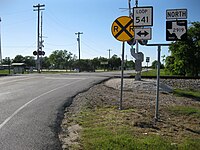
 Loop 541 sign a short way southwest of the Future I-69/US 59 exit
 -
 Marker on Loop 541 gives the history of Kendleton
 -
 Union Pacific railroad crossing at Loop 541 and FM 2919


Loop 543 edit
State Highway Loop 543 | |
|---|---|
| Location | Fayette County |
| Length | 1.665 mi[33] (2.680 km) |
| Existed | February 7, 1983–present |
Loop 543 is located in Fayette County. It runs from SH 71 west of West Point to SH 71 east of West Point.
Loop 543 was designated on February 7, 1983, on the current route along an old routing of SH 71.
Loop 544 edit
State Highway Loop 544 | |
|---|---|
| Location | Nolan County |
| Existed | February 23, 1983[34]–June 21, 1990 |
Loop 544 was designated on February 23, 1983, as a loop off US 84 in Roscoe. On June 21, 1990, Loop 544 was cancelled and transferred to Bus. US 84.
Loop 545 edit
State Highway Loop 545 | |
|---|---|
| Location | Tom Green County |
| Existed | April 20, 1984[35]–November 21, 1996 |
Loop 545 was designated on April 20, 1984, from US 67 northeast 5.1 miles (8.2 km) to Main Street, then north along Main Street 0.5 mile to US 67 along an old routing of US 67. On March 29, 1988, a 1.1-mile (1.8 km) section from US 87 to FM 380 was removed and returned to the city of San Angelo. The remainder of Loop 545 was cancelled on November 21, 1996, and transferred to Bus. US 67.
Loop 546 edit
State Highway Loop 546 | |
|---|---|
| Location | Midland County |
| Existed | April 9, 1984[36]–June 21, 1990 |
Loop 546 was designated on April 9, 1984, from Loop 250 east and south 3.5 miles (5.6 km) to Wall Avenue, then east 1.3 miles (2.1 km) along Wall Avenue to SH 349 (now Bus. SH 349), then south along SH 349 to Florida Avenue, then southeast 2.5 miles (4.0 km) along Florida Avenue and Garden City Highway to I-20/SH 158 along an old routing of SH 158. On June 21, 1990, Loop 546 was cancelled and transferred to Bus. SH 158.
Loop 547 edit
State Highway Loop 547 | |
|---|---|
| Location | San Augustine County |
| Length | 1.222 mi[37] (1.967 km) |
| Existed | July 24, 1984–present |
Loop 547 is located in San Augustine County. Both of its termini are at SH 21 within the San Augustine city limits.
Loop 547 was designated on July 24, 1984, on its current route. It is a former routing of SH 21.
Loop 549 edit
State Highway Loop 549 | |
|---|---|
| Location | Nolan County |
| Existed | September 27, 1985[38]–June 21, 1990 |
Loop 549 was designated on September 27, 1985, from SH 70, 2 miles (3.2 km) west of Sweetwater, south 2 miles (3.2 km) to Loop 432 (now Business I-20). The route was signed, but not designated, as SH 70. Loop 549 was cancelled on June 21, 1990, as the SH 70 designation became official.
Loop 550 edit
State Highway Loop 550 | |
|---|---|
| Location | Oldham County |
| Existed | April 18, 1985[39]–June 21, 1990 |
Loop 550 was designated on April 18, 1985, as a loop off I-40 in Adrian along an old routing of US 66. On June 21, 1990, Loop 550 was cancelled and transferred to Business I-40-B.
Loop 551 edit
State Highway Loop 551 | |
|---|---|
| Location | Oldham County |
| Existed | April 18, 1985[40]–June 21, 1990 |
Loop 551 was designated on April 18, 1985, as a loop off I-40 in Vega along an old routing of US 66. On June 21, 1990, Loop 551 was cancelled and transferred to Business I-40-C.
Loop 552 edit
State Highway Loop 552 | |
|---|---|
| Location | Potter and Carson counties |
| Existed | April 18, 1985[41]–October 25, 1990 |
Loop 552 was designated on April 18, 1985, from I-40 west of Amarillo east, north, and east 9 miles (14 km) to US 60/US 87, then east and northeast 10.8 miles (17.4 km) along US 60 to its intersection with Loop 552, then southeast 4.6 miles (7.4 km) to I-40 along an old routing of US 66. On October 25, 1990, Loop 552 was cancelled and transferred to Business I-40-D.
Loop 554 edit
State Highway Loop 554 | |
|---|---|
| Location | Carson and Gray counties |
| Existed | April 18, 1985[42]–June 21, 1990 |
Loop 554 was designated on April 18, 1985, as a loop off I-40 in Groom along an old routing of US 66. On June 21, 1990, Loop 554 was cancelled and transferred to Business I-40-F.
Loop 555 edit
State Highway Loop 555 | |
|---|---|
| Location | Gray County |
| Existed | April 18, 1985[43]–June 21, 1990 |
Loop 555 was designated on April 18, 1985, as a loop off I-40 in McLean along an old routing of US 66. On June 21, 1990, Loop 555 was cancelled and transferred to Business I-40-H.
Loop 556 edit
State Highway Loop 556 | |
|---|---|
| Location | Wheeler County |
| Existed | April 18, 1985[44]–March 24, 1993 |
Loop 556 was designated on April 18, 1985, as a loop off I-40 in Shamrock along an old routing of US 66. On March 24, 1993, Loop 556 was cancelled and transferred to Business I-40-J.
Loop 558 edit
State Highway Loop 558 | |
|---|---|
| Location | Brazoria County |
| Existed | January 15, 1986[45]–September 29, 1992 |
Loop 558 was designated on January 15, 1986, from SH 35 southwest and west 4.9 miles (7.9 km) to the intersection of SH 35 and SH 288. On February 25, 1987, the route was transferred to SH 35 and Loop 558 was reassigned to an old routing of SH 35 from SH 288 east 3.7 miles (6.0 km) to SH 35. Loop 558 was cancelled on September 29, 1992, and transferred to FM 523.
Loop 560 edit
State Highway Loop 560 | |
|---|---|
| Location | Ellis and Dallas counties |
| Existed | January 28, 1987[46]–June 21, 1990 |
Loop 560 was located in Ellis and Dallas counties. It was the former alignment of US 75 through Ferris. It is now Business I-45.
Loop 561 edit
State Highway Loop 561 | |
|---|---|
| Location | Ellis County |
| Length | 0.936 mi[47] (1,506 m) |
| Existed | January 28, 1987–present |
Loop 561 is located in Ellis County. It is the former alignment of US 75 through Trumbull. Both of its termini are at I-45.
Loop 561 was designated on January 28, 1987, on the current route.
Loop 562 edit
State Highway Loop 562 | |
|---|---|
| Location | Ellis County |
| Existed | January 28, 1987[48]–June 21, 1990 |
Loop 562 was located in Ellis County. It was the former alignment of US 75 through Palmer. It is now Business I-45.
Loop 564 edit
State Highway Loop 564 | |
|---|---|
| Location | Wood County |
| Length | 9.800 mi[49] (15.772 km) |
| Existed | March 25, 2010–present |
Loop 564 encircles Mineola.
Loop 564 was designated on March 25, 2010, on the current route as a replacement of FM 564.
Loop 564 (1987) edit
State Highway Loop 564 | |
|---|---|
| Location | Navarro County |
| Existed | January 28, 1987[49]–June 21, 1990 |
A previous route designated Loop 564 was located in Navarro County. It was the former alignment of US 75 through Corsicana. It is now Business I-45.[49]
Loop 566 edit
State Highway Loop 566 | |
|---|---|
| Location | Haskell and Jones counties |
| Existed | May 2, 1988[50]–June 21, 1990 |
Loop 566 was designated on May 2, 1988, from US 287/SH 283, south along SH 6, then west to US 277 along an old routing of US 277. On June 21, 1990, Loop 566 was cancelled and transferred to Bus. US 277.
Loop 567 edit
State Highway Loop 567 | |
|---|---|
| Location | Hood County |
| Length | 4.035 mi[51] (6.494 km) |
| Existed | November 25, 1986–present |
Loop 567 is located in Hood County. It runs from US 377 west of Granbury to Bus. US 377 east of Granbury.
Loop 567 was designated on November 25, 1986, from US 377 west of Granbury northeast to FM 51 north of town. On May 25, 2000, by district request, the road was extended 2.25 miles (3.62 km) east and south to Bus. US 377.
Loop 569 edit
State Highway Loop 569 | |
|---|---|
| Location | Wise County |
| Existed | April 23, 1987[52]–June 21, 1990 |
Loop 569 was designated on April 23, 1987, as a loop off US 380 in Decatur along an old routing of US 380. On June 21, 1990, Loop 569 was cancelled and transferred to Bus. US 380.
Loop 570 edit
State Highway Loop 570 | |
|---|---|
| Location | Tom Green County |
| Length | 1.903 mi[53] (3.063 km) |
| Existed | March 19, 1990–present |
Loop 570 is located in Tom Green County. It is the former route of US 87 through Wall.
Loop 571 edit
State Highway Loop 571 | |
|---|---|
| Location | Rusk County |
| Length | 5.902 mi[54] (9.498 km) |
| Existed | September 29, 1987–present |
Loop 571 is located in Rusk County. It runs from US 259 north of Henderson to US 259 south of Henderson.
Loop 571 was designated on September 29, 1987, on the current route as a replacement of FM 454.
Loop 573 edit
State Highway Loop 573 | |
|---|---|
| Location | Liberty County |
| Length | 3.159 mi[55] (5.084 km) |
| Existed | December 31, 1987–present |
Loop 573 is located in Liberty County. It runs from I-69/US 59 north of Cleveland to I-69/US 59 south of Cleveland.
Loop 573 was designated on December 31, 1987, on the current route along an old routing of US 59.
Loop 574 edit
State Highway Loop 574 | |
|---|---|
| Location | McLennan County |
| Length | 1.500 mi[56] (2.414 km) |
| Existed | December 21, 1987–present |
Loop 574 is located in McLennan County. It runs from I-35 to Loop 484.
Loop 574 was designated on December 21, 1987, on the current route.
Loop 577 edit
State Highway Loop 577 | |
|---|---|
| Location | Concho County |
| Length | 1.063 mi[57] (1.711 km) |
| Existed | October 6, 1991–present |
Loop 577 is located in Concho County. It is the former route of US 87 through Vick.
Loop 590 edit
State Highway Loop 590 | |
|---|---|
| Location | Cameron County |
| Existed | April 26, 1989[58]–December 21, 1994 |
Loop 590 was designated on April 26, 1989, from US 77 south and southwest 13.9 miles (22.4 km) along Helen Moore Road (now Paso Real Highway) to US 77/US 83 (now I-69E). On December 21, 1994, Loop 590 was cancelled and redesignated as FM 509 to provide a continuous route for FM 509.
Loop 592 edit
State Highway Loop 592 | |
|---|---|
| Location | Bell County |
| Length | 0.700 mi[59] (1,127 m) |
| Existed | May 24, 1990–present |
Loop 592 is located in Bell County. It runs from US 190/I-14 east of Nolanville to US 190/I-14 at Paddy Hamilton Road. The route is unsigned.
Loop 592 was designated on May 24, 1990, on the current route.
Loop 593 edit
State Highway Loop 593 | |
|---|---|
| Location | Hunt County |
| Existed | January 29, 1991[60]–July 15, 1992 |
Loop 593 was a proposed route in Hunt County. It was designated on January 29, 1991, from US 69 in Greenville south and east 5.2 miles (8.4 km) to SH 34. However, the city of Greenville rejected construction of the route, and the designation was cancelled on July 15, 1992.
Loop 635 edit
State Highway Loop 635 | |
|---|---|
| Location | Dallas and Tarrant counties |
| Existed | April 1, 1968[61]–July 31, 1974 |
Loop 635 was located in Dallas and Tarrant counties. It was the temporary designation for the northwestern segment of I-635 from 1968 to 1974.
Loop 820 edit
State Highway Loop 820 | |
|---|---|
| Location | Tarrant County |
| Existed | April 18, 1963[62]–July 13, 1977 |
Loop 820 was located in Tarrant County. It was the temporary designation for segments of I-820 from 1963 to 1977.
Loop 1604 edit
State Highway Loop 1604 | |
|---|---|
| Location | Bexar County |
| Length | 94.387 mi[63] (151.901 km) |
| Existed | June 30, 1977–present |
Loop 1604 serves as the outer highway loop of San Antonio. At nearly 95 miles (153 km) in length, Loop 1604 is the longest state highway loop in Texas.
Loop 1853 edit
State Highway Loop 1853 | |
|---|---|
| Location | Madison County |
| Length | 7.3 mi[72] (11.7 km) |
| Existed | April 30, 2020–present |
Loop 1853 is a proposed loop around the south side of Madisonville as a relief route for SH 21, which is routed through the city. It is proposed to run from US 190/SH 21, 0.7 miles (1.1 km) east of FM 1452, to another point on SH 21, 0.4 miles (0.6 km) west of FM 2346.
Loop 1853 is expected to have two lanes in each direction with four overpasses, at SH 90, SH 75, I-45, and a city-owned road.[citation needed] TxDOT projects construction to begin in 2026.[citation needed]
The number was chosen to commemorate the year that Madison County was established.[73]
References edit
- ^ Transportation Planning and Programming Division (n.d.). "State Highway Loop No. 500". Highway Designation Files. Texas Department of Transportation. Retrieved August 5, 2020.
- ^ Transportation Planning and Programming Division (n.d.). "State Highway Loop No. 505". Highway Designation Files. Texas Department of Transportation. Retrieved August 5, 2020.
- ^ Transportation Planning and Programming Division (n.d.). "State Highway Loop No. 506". Highway Designation Files. Texas Department of Transportation. Retrieved August 5, 2020.
- ^ Transportation Planning and Programming Division (n.d.). "State Highway Loop No. 507". Highway Designation Files. Texas Department of Transportation. Retrieved August 5, 2020.
- ^ Transportation Planning and Programming Division (n.d.). "State Highway Loop No. 508". Highway Designation Files. Texas Department of Transportation. Retrieved August 5, 2020.
- ^ Transportation Planning and Programming Division (n.d.). "State Highway Loop No. 509". Highway Designation Files. Texas Department of Transportation. Retrieved August 5, 2020.
- ^ Transportation Planning and Programming Division (n.d.). "State Highway Loop No. 512". Highway Designation Files. Texas Department of Transportation. Retrieved August 5, 2020.
- ^ Transportation Planning and Programming Division (n.d.). "State Highway Loop No. 513". Highway Designation Files. Texas Department of Transportation. Retrieved August 5, 2020.
- ^ Transportation Planning and Programming Division (n.d.). "State Highway Loop No. 516". Highway Designation Files. Texas Department of Transportation. Retrieved August 5, 2020.
- ^ Transportation Planning and Programming Division (n.d.). "State Highway Loop No. 517". Highway Designation Files. Texas Department of Transportation. Retrieved August 5, 2020.
- ^ Transportation Planning and Programming Division (n.d.). "State Highway Loop No. 518". Highway Designation Files. Texas Department of Transportation. Retrieved August 10, 2020.
- ^ Transportation Planning and Programming Division (n.d.). "State Highway Loop No. 519". Highway Designation Files. Texas Department of Transportation. Retrieved August 10, 2020.
- ^ Transportation Planning and Programming Division (n.d.). "State Highway Loop No. 520". Highway Designation Files. Texas Department of Transportation. Retrieved August 10, 2020.
- ^ Transportation Planning and Programming Division (n.d.). "State Highway Loop No. 521". Highway Designation Files. Texas Department of Transportation. Retrieved August 10, 2020.
- ^ Transportation Planning and Programming Division (n.d.). "State Highway Loop No. 522". Highway Designation Files. Texas Department of Transportation. Retrieved August 10, 2020.
- ^ Transportation Planning and Programming Division (n.d.). "State Highway Loop No. 523". Highway Designation Files. Texas Department of Transportation. Retrieved August 10, 2020.
- ^ Transportation Planning and Programming Division (n.d.). "State Highway Loop No. 524". Highway Designation Files. Texas Department of Transportation. Retrieved August 10, 2020.
- ^ Transportation Planning and Programming Division (n.d.). "State Highway Loop No. 525". Highway Designation Files. Texas Department of Transportation. Retrieved August 10, 2020.
- ^ Transportation Planning and Programming Division (n.d.). "State Highway Loop No. 526". Highway Designation Files. Texas Department of Transportation. Retrieved August 10, 2020.
- ^ Transportation Planning and Programming Division (n.d.). "State Highway Loop No. 528". Highway Designation Files. Texas Department of Transportation. Retrieved August 10, 2020.
- ^ Transportation Planning and Programming Division (n.d.). "State Highway Loop No. 530". Highway Designation Files. Texas Department of Transportation. Retrieved August 10, 2020.
- ^ Transportation Planning and Programming Division (n.d.). "State Highway Loop No. 531". Highway Designation Files. Texas Department of Transportation. Retrieved August 10, 2020.
- ^ Transportation Planning and Programming Division (n.d.). "State Highway Loop No. 532". Highway Designation Files. Texas Department of Transportation. Retrieved August 10, 2020.
- ^ Transportation Planning and Programming Division (n.d.). "State Highway Loop No. 533". Highway Designation Files. Texas Department of Transportation. Retrieved August 10, 2020.
- ^ a b c Transportation Planning and Programming Division (n.d.). "State Highway Loop No. 534". Highway Designation Files. Texas Department of Transportation. Retrieved August 6, 2020.
- ^ "Official MapQuest - Maps, Driving Directions, Live Traffic".
- ^ Transportation Planning and Programming Division (n.d.). "State Highway Loop No. 538". Highway Designation Files. Texas Department of Transportation. Retrieved August 5, 2020.
- ^ Transportation Planning and Programming Division (n.d.). "State Highway Loop No. 539". Highway Designation Files. Texas Department of Transportation. Retrieved August 5, 2020.
- ^ Transportation Planning and Programming Division (n.d.). "State Highway Loop No. 540". Highway Designation Files. Texas Department of Transportation. Retrieved August 6, 2020.
- ^ Transportation Planning and Programming Division (2018). Texas County Mapbook (PDF) (Map) (2018 ed.). 1:72,224. Texas Department of Transportation. p. 1841. Retrieved December 24, 2022.
- ^ a b Transportation Planning and Programming Division (2018). Texas County Mapbook (PDF) (Map) (2018 ed.). 1:72,224. Texas Department of Transportation. p. 1880. Retrieved December 24, 2022.
- ^ Transportation Planning and Programming Division (n.d.). "State Highway Loop No. 541". Highway Designation Files. Texas Department of Transportation. Retrieved August 6, 2020.
- ^ Transportation Planning and Programming Division (n.d.). "State Highway Loop No. 543". Highway Designation Files. Texas Department of Transportation. Retrieved August 6, 2020.
- ^ Transportation Planning and Programming Division (n.d.). "State Highway Loop No. 544". Highway Designation Files. Texas Department of Transportation. Retrieved August 6, 2020.
- ^ Transportation Planning and Programming Division (n.d.). "State Highway Loop No. 545". Highway Designation Files. Texas Department of Transportation. Retrieved August 6, 2020.
- ^ Transportation Planning and Programming Division (n.d.). "State Highway Loop No. 546". Highway Designation Files. Texas Department of Transportation. Retrieved August 6, 2020.
- ^ Transportation Planning and Programming Division (n.d.). "State Highway Loop No. 547". Highway Designation Files. Texas Department of Transportation. Retrieved August 6, 2020.
- ^ Transportation Planning and Programming Division (n.d.). "State Highway Loop No. 549". Highway Designation Files. Texas Department of Transportation. Retrieved August 6, 2020.
- ^ Transportation Planning and Programming Division (n.d.). "State Highway Loop No. 550". Highway Designation Files. Texas Department of Transportation. Retrieved August 6, 2020.
- ^ Transportation Planning and Programming Division (n.d.). "State Highway Loop No. 551". Highway Designation Files. Texas Department of Transportation. Retrieved August 6, 2020.
- ^ Transportation Planning and Programming Division (n.d.). "State Highway Loop No. 552". Highway Designation Files. Texas Department of Transportation. Retrieved August 6, 2020.
- ^ Transportation Planning and Programming Division (n.d.). "State Highway Loop No. 554". Highway Designation Files. Texas Department of Transportation. Retrieved August 6, 2020.
- ^ Transportation Planning and Programming Division (n.d.). "State Highway Loop No. 555". Highway Designation Files. Texas Department of Transportation. Retrieved August 6, 2020.
- ^ Transportation Planning and Programming Division (n.d.). "State Highway Loop No. 556". Highway Designation Files. Texas Department of Transportation. Retrieved August 6, 2020.
- ^ Transportation Planning and Programming Division (n.d.). "State Highway Loop No. 558". Highway Designation Files. Texas Department of Transportation. Retrieved August 6, 2020.
- ^ Transportation Planning and Programming Division (n.d.). "State Highway Loop No. 560". Highway Designation Files. Texas Department of Transportation. Retrieved August 6, 2020.
- ^ Transportation Planning and Programming Division (n.d.). "State Highway Loop No. 561". Highway Designation Files. Texas Department of Transportation. Retrieved August 6, 2020.
- ^ Transportation Planning and Programming Division (n.d.). "State Highway Loop No. 562". Highway Designation Files. Texas Department of Transportation. Retrieved August 6, 2020.
- ^ a b c Transportation Planning and Programming Division (n.d.). "State Highway Loop No. 564". Highway Designation Files. Texas Department of Transportation. Retrieved August 6, 2020.
- ^ Transportation Planning and Programming Division (n.d.). "State Highway Loop No. 566". Highway Designation Files. Texas Department of Transportation. Retrieved August 5, 2020.
- ^ Transportation Planning and Programming Division (n.d.). "State Highway Loop No. 567". Highway Designation Files. Texas Department of Transportation. Retrieved August 5, 2020.
- ^ Transportation Planning and Programming Division (n.d.). "State Highway Loop No. 569". Highway Designation Files. Texas Department of Transportation. Retrieved August 5, 2020.
- ^ Transportation Planning and Programming Division (n.d.). "State Highway Loop No. 570". Highway Designation Files. Texas Department of Transportation. Retrieved August 6, 2020.
- ^ Transportation Planning and Programming Division (n.d.). "State Highway Loop No. 571". Highway Designation Files. Texas Department of Transportation. Retrieved August 6, 2020.
- ^ Transportation Planning and Programming Division (n.d.). "State Highway Loop No. 573". Highway Designation Files. Texas Department of Transportation. Retrieved August 6, 2020.
- ^ Transportation Planning and Programming Division (n.d.). "State Highway Loop No. 574". Highway Designation Files. Texas Department of Transportation. Retrieved August 6, 2020.
- ^ Transportation Planning and Programming Division (n.d.). "State Highway Loop No. 577". Highway Designation Files. Texas Department of Transportation. Retrieved August 6, 2020.
- ^ Transportation Planning and Programming Division (n.d.). "State Highway Loop No. 590". Highway Designation Files. Texas Department of Transportation. Retrieved August 6, 2020.
- ^ Transportation Planning and Programming Division (n.d.). "State Highway Loop No. 592". Highway Designation Files. Texas Department of Transportation. Retrieved August 6, 2020.
- ^ Transportation Planning and Programming Division (n.d.). "State Highway Loop No. 593". Highway Designation Files. Texas Department of Transportation. Retrieved August 6, 2020.
- ^ Transportation Planning and Programming Division (n.d.). "State Highway Loop No. 635". Highway Designation Files. Texas Department of Transportation. Retrieved August 5, 2020.
- ^ Transportation Planning and Programming Division (n.d.). "State Highway Loop No. 820". Highway Designation Files. Texas Department of Transportation. Retrieved November 15, 2022.
- ^ Transportation Planning and Programming Division (n.d.). "State Highway Loop No. 1604". Highway Designation Files. Texas Department of Transportation. Retrieved August 5, 2020.
- ^ Transportation Planning and Programming Division (n.d.). "State Highway Loop No. 1604". Highway Designation Files. Texas Department of Transportation. Retrieved February 25, 2008.
- ^ Transportation Planning and Programming Division (n.d.). "Farm to Market Road No. 1604". Highway Designation Files. Texas Department of Transportation. Retrieved February 25, 2008.
- ^ Transportation Planning and Programming Division (n.d.). "State Highway Loop No. 334". Highway Designation Files. Texas Department of Transportation. Retrieved February 25, 2008.
- ^ Transportation Planning and Programming Division (n.d.). "Farm to Market Road No. 1518". Highway Designation Files. Texas Department of Transportation. Retrieved February 25, 2008.
- ^ Transportation Planning and Programming Division (n.d.). "Farm to Market Road No. 3465". Highway Designation Files. Texas Department of Transportation. Retrieved February 25, 2008.
- ^ Transportation Planning and Programming Division (n.d.). "Farm to Market Road No. 327". Highway Designation Files. Texas Department of Transportation. Retrieved February 25, 2008.
- ^ Transportation Planning and Programming Division (n.d.). "Farm to Market Road No. 1937". Highway Designation Files. Texas Department of Transportation. Retrieved February 25, 2008.
- ^ Transportation Planning and Programming Division (n.d.). "Farm to Market Road No. 3499". Highway Designation Files. Texas Department of Transportation. Retrieved February 25, 2008.
- ^ "Minute Order 115735" (PDF). Texas Transportation Commission. April 30, 2020. Retrieved August 11, 2020.
- ^ Reynolds, Roy R. (November 27, 2019). "Madison County taps history to name planned loop" (PDF). The Madisonville Meteor. Retrieved December 23, 2022.