This article needs additional citations for verification. (October 2009) |
Tejgaon (Bengali: তেজগাঁও) is a thana of Dhaka District in the Division of Dhaka, Bangladesh. It is in the centre of Dhaka, the capital. In 2006, the boundaries of the thana were redrawn when Tejgaon Industrial Area Thana was created out of the former larger area[4] and again in 2009 when Sher-e-Bangla Nagar Thana was created.[5]
Tejgaon Thana
তেজগাঁও থানা | |
|---|---|
 Tejgaon Thana (Police Station) | |
 Expandable map of vicinity of Tejgaon Thana | |
 Tejgaon Thana Location of Tejgaon Thana within Dhaka  Tejgaon Thana Location of Tejgaon Thana within Dhaka Division  Tejgaon Thana Location of Tejgaon Thana within Bangladesh | |
| Coordinates: 23°45′50″N 90°23′30″E / 23.76395°N 90.39172°E | |
| Country | |
| Division | Dhaka Division |
| District | Dhaka District |
| Established as a thana | 2006 |
| Area | |
| • Total | 2.74 km2 (1.06 sq mi) |
| Elevation | 23 m (75 ft) |
| Population (2011)[2] | |
| • Total | 148,255 |
| • Density | 54,108/km2 (140,140/sq mi) |
| Time zone | UTC+6 (BST) |
| Area code | 1208[3] |
This is an important area of Dhaka city as the prime minister's office is here. It is bounded by Mohakhali to the north, Old Airport Road to the east and Moghbazar-Malibagh to the south and Dhanmondi to the west. It consists of several localities, including Tejgaon Industrial Area, Kawran Bazar, Nakhalpara, Shaheen Bag, Arjat para, East Raja Bazar, West Raja Bazar, Tejturi Bazar, Monipuripara and Tejkunipara.

Geography edit
Tejgaon Thana is bounded by Kafrul Thana, Cantonment Thana and Tejgaon Industrial Area Thana on the north, Kalabagan Thana and Ramna Thana on the south, Tejgaon Industrial Area Thana on the east and Sher-e-Bangla Nagar Thana and Kafrul Thana on the west.. The total area is 2.74 square kilometres (1.06 sq mi).[4]
Demographics edit
According to the 2011 Bangladesh census, Tejgaon Thana had 29,622 households and a population of 148,255, 100% of whom lived in urban areas. 6.3% of the population was under the age of 5. The literacy rate (age 7 and over) was 77.6%, compared to the national average of 51.8%.[6][7]
Urban layout edit
Historically, the area has been a centre of industrial activity in the city. Numerous plants and factories are in Tejgaon, in such diverse industries as garments, food processing, metal works, pharmaceuticals, etc. Indeed, the names of places in Tejgaon indicate as much:
- Nabisco junction (named after the Nabisco biscuit factory)
- Tibet bus stop (named after a famous cosmetics manufacturer)
- Rahim Metal Mosque
- MP Hostel
- Technical Teachers Training College (TTTC)
- Bashundhara City
- Bangladesh Water Development Board (পানি ভবন)
Economy edit

Tejgaon has emerged as an important business district of Dhaka. The first five-star hotel of Bangladesh, Pan Pacific Hotel Sonargaon, is in Kawran Bazar, Tejgaon. The main offices of the Daily Prothom Alo, the Daily Star (Bangladesh), The Independent, and several other newspapers are here. Also, the office and studio of television channels Ekushey Television, NTV, ATN Bangla, Boishakhi TV, Channel i and Channel 1 are at Tejgaon. The main campus of Ahsanullah University of Science and Technology is here as well.
Tejgaon has the headquarters for the Trading Corporation of Bangladesh.
Banks edit
Almost every bank operating in Bangladesh has an outlet in Tejgaon. Foreign banks such as Citi, HSBC and Standard Chartered have branches here, with HSBC and Standard Chartered having multiple ATM booths in the area. Local banks like BRAC Bank, United Commercial Bank Limited, AB Bank, Dutch Bangla Bank, Jamuna Bank have branches. ICICI Bank Ltd., second largest bank of India, has a representative office in UTC building next to Bashundhara city.
Restaurants edit
There are many well-known restaurants in Tejgaon: Star Hotel and Restaurant, Marine Restaurant, Park Town, Yan-Ji Chinese Restaurant, Hiramon Kabab Ghar, Ciao Bistro and Aromaz at Hotel Pan Pacific Shonargaon, Dominous Pizza and Salt Grill Restaurant in Bashundhara City and others.
There are bars in Tejgaon: Hotel Red Button and Balcony Bar at Hotel Pan Pacific Shonargaon, etc.
Points of interest edit
-
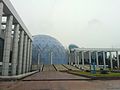 Novo Theatre (Planetarium)
 -
 Ratna Dip
 -
 SAARC Foara
 -
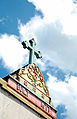 Holy Rosary Church
.jpg)
.JPG)


- Prime Minister's Office
- Jatiyo Sangshad Bhaban
- Bangabandhu Sheikh Mujibur Rahman Novo Theatre (Planetarium)
- Holy Rosary Church (Dhaka)
- Bashundhara City
- Bijoy Shoroni Fountain
- SAARC Fountain
- Island of Pearl-Ratna dip in front of Prime Minister Office
- Pan Pacific Sonargaon
- Bangladesh Air Force Museum
Parks edit
Chandrima Uddan (sometimes called Zia Uddan) is a park beside the Jatiyo Sangshad Bhaban. The name means "Moonlight Park" in Bengali.
The park is where the former Bangladeshi President Ziaur Rahman was buried. It is connected to the road with a bridge which runs over the Crescent Lake. The park is a very common place to spend leisure time. It is very popular for morning and evening walks.
There is Farmgate Park, which is a very popular destination for young people.
Airport edit
Tejgaon Airport (ICAO: VGTJ) at Tejgaon, was the country's sole international airport before the construction of the new Hazrat Shahjalal International Airport (IATA: DAC, ICAO: VGHS) which was named Zia International airport (ICAO: VGZR).
The first Royal Indian Air Force light fighter landed on the under-construction runway of Tejgaon at the beginning of 1943.
Following the transfer of civilian flights to the new Hazrat Shahjalal International Airport in 1981, Tejgaon was taken under the control of the Bangladesh Air Force & Bangladesh Army.
Education edit
Over the last 50 years many schools, colleges and private universities have developed around the area — Bangladesh University of Textiles, Dhaka Polytechnic Institute, Hamdard Public College, Government Science College, Holy Cross College, Tejgaon College, Tejgaon Govt High School, Tejgaon Government Girls' High School, Green University of Bangladesh, B.A.F Shaheen College, and BAF Shaheen English Medium School are the most well known. The National Institute of Ear, Nose and Throat (ENT) is also in Tejgaon.
Gallery edit


See also edit
References edit
- ^ "Geographic coordinates of Dhaka, Bangladesh". DATEANDTIME.INFO. Retrieved 7 July 2016.
- ^ Bangladesh Bureau of Statistics (2011). "Population & Housing Census" (PDF). Bangladesh Government. Archived from the original (PDF) on 3 September 2017. Retrieved 17 April 2015.
- ^ "ঢাকা পোস্টকোড". ডাক অধিদপ্তর. Retrieved 2024-01-17.
- ^ a b Ahmed, Syed Shabbir (2012). "Tejgaon Thana". In Islam, Sirajul; Jamal, Ahmed A. (eds.). Banglapedia: National Encyclopedia of Bangladesh (Second ed.). Asiatic Society of Bangladesh.
- ^ Nahar, Shamsun (2012). "Sher-E-Bangla Nagar Thana". In Islam, Sirajul; Jamal, Ahmed A. (eds.). Banglapedia: National Encyclopedia of Bangladesh (Second ed.). Asiatic Society of Bangladesh.
- ^ "Community Report: Dhaka" (PDF). Population & Housing Census 2011. Bangladesh Bureau of Statistics. Retrieved 2018-08-15.
- ^ "Population and Housing Census 2011: Bangladesh at a Glance" (PDF). Bangladesh Bureau of Statistics. Archived from the original (PDF) on July 28, 2014. Retrieved July 21, 2014.