Tanjungbalai[fn 1], also colloquially written as Tanjung Balai, is a city in North Sumatra province, Indonesia, on the estuary of the Asahan River. It has an area of 60.52 square kilometers (23.37 sq mi) and the sixth largest kota (urban) population in North Sumatra with 154,445 inhabitants in the 2010 census[2] and 176,027 at the 2020 Census;[3] the official estimate as at mid 2023 was 183,170 - comprising 92,715 males and 90,455 females.[1] The town has a ferry terminal with services to Port Klang, Malaysia, and the city-island of Singapore.
Tanjungbalai | |
|---|---|
| City of Tanjungbalai Kota Tanjungbalai | |
| Other transcription(s) | |
| • Jawi | تنجوڠ بالاي |
| • Chinese | 丹戎巴萊 |
| • Hokkien | tan jiông pa lâi |
 Tanjungbalai city, 2008 | |
 Coat of arms | |
| Nickname: Kota Kerang (Scallops City) | |
 Location within North Sumatra | |
| Coordinates: 2°58′12″N 99°48′0″E / 2.97000°N 99.80000°E | |
| Country | |
| Province | |
| Government | |
| • Acting Mayor | Waris Thalib |
| • Chairman of City's Council of Representatives | Tengku Eswin (Golkar) |
| • Vice Chairmen of City's Council of Representatives | Surya Darma (PDI-P) and Syahrial Bakti (National Awakening Party) |
| Area | |
| • Total | 60.52 km2 (23.37 sq mi) |
| Population (mid 2023 estimate[1]) | |
| • Total | 183,170 |
| • Density | 3,000/km2 (7,800/sq mi) |
| Time zone | UTC+7 (Indonesia Western Time) |
| Area code | (+62) 623 |
| Website | www |


Formerly known as Tanjungbalai-Asahan, this area was once a district within Asahan Regency until it was granted city status in 1984. However, the identifier "Asahan" is still used to distinguish it from the port of the same name on Great Karimun island. After the separation of Tanjungbalai from Asahan Regency, it technically became an enclave within the regency.
Administrative divisions edit
The city is divided administratively into six districts (kecamatan), tabulated below with their areas and their populations at the 2010 Census [2] and 2020 Census,[3] together with the official estimates as at mid 2023.[1] The table also includes the number of administrative villages in each district (all classed as urban kelurahan) and its post codes.
| Kode Wilayah |
Name of District (kecamatan) |
Area in km2 |
Pop'n Census 2010 |
Pop'n Census 2020 |
Pop'n Census mid 2023 |
No. of kelurahan |
Post codes |
|---|---|---|---|---|---|---|---|
| 12.74.05 | Datuk Bandar | 22.49 | 33,797 | 41,544 | 44,121 | 5 | 21361, 21362, 21368, 21369 |
| 12.74.06 | Datuk Bandar Timur (East Datuk Bandar) |
14.57 | 26,942 | 30,492 | 31,631 | 5 | 21364 - 21367 |
| 12.74.01 | Tanjungbalai Selatan (South Tanjungbalai) |
1.98 | 19,330 | 19,277 | 19,320 | 6 | 21311 - 21316 |
| 12.74.02 | Tanjungbalai Utara (North Tanjungbalai) |
0.84 | 15,862 | 16,173 | 16,277 | 5 | 21321 - 21325 |
| 12.74.03 | Sei Tualang Raso | 8.09 | 22,712 | 27,283 | 28,796 | 5 | 21341 - 21345 |
| 12.74.04 | Teluk Nibung (Nibung Bay) |
12.55 | 35,802 | 41,258 | 43,025 | 5 | 21331 - 21335 |
| Totals | 60.52 | 154,445 | 176,027 | 183,170 | 31 |
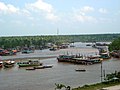
Tanjungbalai Asahan Port (Teluk Nibung Port) edit
The Port (which actually lies in Tanjungbalai District of Asahan Regency, between the city and the coast) has warehouse facilities and stacking fields. This port also carries out cargo and passenger services with activities mainly in exporting vegetables and fish to Malaysia. The port has passenger services to Port Klang and Port of Melintang Forest, Perak. Teluk Nibung passenger terminal currently has an area of about 2,500 square metres, consisting of two floors with a capacity of around 800 people. 1st floor for check-in, customs, immigration for arrivals, VIP rooms, quarantine rooms and 2nd floor for immigration rooms for departures, passenger waiting rooms, food court and coffee shops.[4][5]
Climate edit
Tanjungbalai has a tropical rainforest climate (Af) with moderate rainfall from January to July and heavy rainfall from August to December.
| Climate data for Tanjungbalai | |||||||||||||
|---|---|---|---|---|---|---|---|---|---|---|---|---|---|
| Month | Jan | Feb | Mar | Apr | May | Jun | Jul | Aug | Sep | Oct | Nov | Dec | Year |
| Mean daily maximum °C (°F) | 31.2 (88.2) |
31.6 (88.9) |
32.0 (89.6) |
31.9 (89.4) |
32.2 (90.0) |
32.1 (89.8) |
31.8 (89.2) |
31.6 (88.9) |
31.2 (88.2) |
31.0 (87.8) |
30.6 (87.1) |
30.8 (87.4) |
31.5 (88.7) |
| Daily mean °C (°F) | 26.4 (79.5) |
26.6 (79.9) |
27.0 (80.6) |
27.1 (80.8) |
27.5 (81.5) |
27.3 (81.1) |
26.9 (80.4) |
26.9 (80.4) |
26.7 (80.1) |
26.7 (80.1) |
26.3 (79.3) |
26.4 (79.5) |
26.8 (80.3) |
| Mean daily minimum °C (°F) | 21.6 (70.9) |
21.7 (71.1) |
22.0 (71.6) |
22.4 (72.3) |
22.8 (73.0) |
22.5 (72.5) |
22.1 (71.8) |
22.2 (72.0) |
22.3 (72.1) |
22.4 (72.3) |
22.1 (71.8) |
22.0 (71.6) |
22.2 (71.9) |
| Average rainfall mm (inches) | 129 (5.1) |
89 (3.5) |
102 (4.0) |
120 (4.7) |
128 (5.0) |
120 (4.7) |
121 (4.8) |
168 (6.6) |
213 (8.4) |
271 (10.7) |
219 (8.6) |
183 (7.2) |
1,863 (73.3) |
| Source: Climate-Data.org[6] | |||||||||||||
Gallery edit
-
 Tanjungbalai in 1895
 -
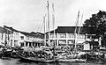 Fishing port in Tanjungbalai, 1900s
 -
 Welcome to Tanjungbalai signboard
 -
 Sei Asahan Bridge


References edit
- ^ a b c Badan Pusat Statistik, Jakarta, 28 February 2024, Kota Tanjungbalai Dalam Angka 2024 (Katalog-BPS 1102001.1274)
- ^ a b Biro Pusat Statistik, Jakarta, 2011.
- ^ a b Badan Pusat Statistik, Jakarta, 2021.
- ^ "Terminal Internasional Teluk Nibung Dioperasikan Jelang Tahun Baru". Medan Business Daily. Retrieved 11 January 2019.
- ^ "Pelindo 1 Lakukan Modernisasi Pelabuhan Tanjungbalai Asahan". Tribun News. Retrieved 11 January 2019.
- ^ "Climate: Tanjungbalai". Climate-Data.org. Retrieved 6 November 2020.
Notes edit
- ^ The city's name is correctly and officially spelled as Tanjungbalai