Talk:Malaysia Airlines Flight 370/Archive 10
| This is an archive of past discussions. Do not edit the contents of this page. If you wish to start a new discussion or revive an old one, please do so on the current talk page. |
| Archive 5 | ← | Archive 8 | Archive 9 | Archive 10 | Archive 11 | Archive 12 |
Compiling a search assets list
By using this Marinetraffic.com website's AIS+GPS info about the ships whereabouts - in addition to additional reliable sources, I have now succeeded to compile a complete list of all the employed ships in the search areas. Danish Expert (talk) 12:18, 10 April 2014 (UTC) -- updated 23 April --
Extended content
|
|---|
Perhaps we should compile a small wikitable listing all the above ship names sourced by each ship link, to get a nice overview of all the ships currently taking part in the Australian-led search operation? Please note, I do not suggest we create/upload a day by day table to the article - just an overall factual table with name and nationality of all ships + aircraft + submarines that were employed to help with the search in the Australian-led search area (from 18 March and onwards). The name of aircraft+submarines can be added to the list by using the direct AMSA+JACC media briefings as reference. Danish Expert (talk) 12:18, 10 April 2014 (UTC) My objective is still only to create an overall wikitable rather than a daily count, but for that purpose I had to do a daily count to be sure not making any mistakes. Below is a copy of my daily count of assets being active in the search area. Danish Expert (talk) 17:30, 15 April 2014 (UTC)
Aircraft active in the search area:
Note: The AMSA chartered civilian aircraft acting as a communications relay during the days 28 March - 2 April, was most likely one of the already noted Bombardier Global Express jets.
Observation: For all searching days at 15 April onwards, JACC counted all official searching ships exceeding [92-106]E / -[18-30]S for being outside the "search area", and during the same days only 1 merchant ship (on 18 April) was tasked/deployed to search. In average, each day 3 merchant ships transited through the search area, but as none of those additional merchant ships had been tasked by JACC to search, then none of them were included in the JACC communicated count of searching ships.
Additional general search status for the Chinese search operations:
Corrections to the above search asset lists
References
|
Proposal to create an overall search assets wikitable
Perhaps we should compile a small wikitable listing all the above ship names sourced by each ship link, to get a nice overview of all the ships currently taking part in the Australian-led search operation? Please note, I do not suggest we create/upload a day by day table to the article - just an overall factual table with name and nationality of all ships + aircraft + submarines that were employed to help with the search in the Australian-led search area (from 18 March and onwards). The name of aircraft+submarines can be added to the list by using the direct AMSA+JACC media briefings as reference. Danish Expert (talk) 12:18, 10 April 2014 (UTC)
- I think adding such a table would be WP:RECENTISM, as well as not being particularly useful, and almost impossible to keep entirely accurate or up to date. Ships are moving in and out of the search area, and ships are joining and leaving the search operation all the time. In a few months time, this aspect will be reduced to something like At it's peak, the search involved over xx ships and YY aircraft from ZZ countries. Regards, Lynbarn (talk) 08:00, 11 April 2014 (UTC)
- To me it seems reasonable enough only to list those ships who permanently search in the area, and not those who are only transiting through. In that way we would also avoid WP:Recentism, but still provide a fair picture of the stationary assets employed during the search, which tells us the story about how intense the search was by numbers. At the same time I will propose we add an extra column in the suggested table, showing the day periods each ships + aircraft were searching. The table could either be limited to the period 4 April onwards (the last northerly search area) or include the entire period from 18 March (including all search efforts under the auspice of the Aussies). I tend to prefer the latter (the entire period since 18 March). Basically the table will not be out-of-the-order huge, so far, I guess it will entail a total of 13 ships + 14 aircraft + 1 submarine (as far as I know none of the originally employed stationary assets so far have been removed). Most readers will find it interesting to get such an overview presented by table, partly as it show the amount of employed assets (with references linking to further details) and partly as it show how many assets the various nations has invested in the Australian-led search operation. Danish Expert (talk) 08:21, 11 April 2014 (UTC)
- Still dont support the sort of detail that Danish Expert wants clearly far to in depth for this article, which is why it was suggested that the Search for Malaysia Airlines Flight 370 was created for the story about the search, although that currently doesnt have much support. MilborneOne (talk) 18:20, 14 April 2014 (UTC)
- Agreed, MilborneOne. Perhaps, Danish Expert, now is the time for you to copy the search section (leaving it where it is in the current article) and use that as the basis for the extended search article. Regards, Lynbarn (talk) 20:14, 14 April 2014 (UTC)
- Danish Expert, before using any of the above in the Search for Malaysia Airlines Flight 370 article, or elsewhere, might I just point out that in English, the plural of aircraft is aircraft, not aircrafts regards, Lynbarn (talk) 00:45, 16 April 2014 (UTC)
- It's a shame you decided to put in all that work, but I feel that the reader would not want/need to know the name and number of ships and aircraft in use on a daily basis. I already removed the brief mention someone inserted into the table. I think it would ultimately be of service for the reader to know the final global number of assets used and countries helping out, such as that provided for the earlier heavy-mobilisation phase. -- Ohc ¡digame! 06:49, 16 April 2014 (UTC)
- First: I agree the overall timetable in the Malaysia Airlines Flight 370 article should not include any daily count of ships and planes. But this is not what we discuss here! Our discussion is only about whether or not it would be appropriate to compile a collapsible wikitable summarizing the name of all the global assets being deployed in the correct search area, to be added at the upcoming subarticle Search for Malaysia Airlines Flight 370. In that context, I also considered this new wikitable perhaps could have a dato interval column, displaying the dates of deployment time for each of the official search assets. Just to proof that such an idea is not exceeding the realms of what the Wikipedia policies allow for, I can refer you to the existence of this similar asset table at Piracy_in_Somalia#Vessels_in_operation.
- All this being said, and now only speaking about how many details we should include in this main articles summary chapter for "International collaboration", your proposed summary line would not be detailed enough, and in fact it is misleading. The first misleading part is, that 50% of your 26 nations involved in the search at the peak of 15 March, only contributed with historic radar+satellite data and had no planes/ships deployed in active real time search. The second misleading part is, that it is totally encyclopedic irrelevant to tell readers how many assets were involved searching at the "incorrect search areas" (which was counted as of 15 March to be 60 ships and 50 aircraft). Its far more encyclopedic relevant to have a summary line telling (at least in addition to your 15 March status), how many search assets were deployed to search the "correct search area" defined per 18 March and onwards as the "South Indian Ocean". The assets permanently deployed in the correct area from 18 March to 20 April, was around 20 aircraft + 17 ships + 1 submarine (which by numbers was roughly 1/3 compared to the deployment of assets in the "incorrect area"); and with all those assets in the "correct area" being delivered and financed by only 8 nations. I of course accept we do not include my wikitable listing those assets in the main article, but still maintain it would be both relevant and appropriate to include my proposed collapsible wikitable in the subarticle Search for Malaysia Airlines Flight 370. Danish Expert (talk) 08:56, 20 April 2014 (UTC)
- It's a shame you decided to put in all that work, but I feel that the reader would not want/need to know the name and number of ships and aircraft in use on a daily basis. I already removed the brief mention someone inserted into the table. I think it would ultimately be of service for the reader to know the final global number of assets used and countries helping out, such as that provided for the earlier heavy-mobilisation phase. -- Ohc ¡digame! 06:49, 16 April 2014 (UTC)
- Danish Expert, before using any of the above in the Search for Malaysia Airlines Flight 370 article, or elsewhere, might I just point out that in English, the plural of aircraft is aircraft, not aircrafts regards, Lynbarn (talk) 00:45, 16 April 2014 (UTC)
- Agreed, MilborneOne. Perhaps, Danish Expert, now is the time for you to copy the search section (leaving it where it is in the current article) and use that as the basis for the extended search article. Regards, Lynbarn (talk) 20:14, 14 April 2014 (UTC)
- Still dont support the sort of detail that Danish Expert wants clearly far to in depth for this article, which is why it was suggested that the Search for Malaysia Airlines Flight 370 was created for the story about the search, although that currently doesnt have much support. MilborneOne (talk) 18:20, 14 April 2014 (UTC)
- To me it seems reasonable enough only to list those ships who permanently search in the area, and not those who are only transiting through. In that way we would also avoid WP:Recentism, but still provide a fair picture of the stationary assets employed during the search, which tells us the story about how intense the search was by numbers. At the same time I will propose we add an extra column in the suggested table, showing the day periods each ships + aircraft were searching. The table could either be limited to the period 4 April onwards (the last northerly search area) or include the entire period from 18 March (including all search efforts under the auspice of the Aussies). I tend to prefer the latter (the entire period since 18 March). Basically the table will not be out-of-the-order huge, so far, I guess it will entail a total of 13 ships + 14 aircraft + 1 submarine (as far as I know none of the originally employed stationary assets so far have been removed). Most readers will find it interesting to get such an overview presented by table, partly as it show the amount of employed assets (with references linking to further details) and partly as it show how many assets the various nations has invested in the Australian-led search operation. Danish Expert (talk) 08:21, 11 April 2014 (UTC)
- I apologise for not being precise. I would still oppose a list as above as a moving target, and I fail to see how such a list is of interest to anything but a very narrow section of readers. It's given in briefings and other primary sources, with little or no coverage of this detail otherwise in mainstream media. The more you go updating the above daily status, the more it frightens me. However, I think it would still be possible to have a global total of assets in use in the important fourth and fifth phases that would be of interest to readers. -- Ohc ¡digame! 07:43, 21 April 2014 (UTC)
What is the point of this talk page section?
Whilst I appreciate the considerable time and effort that has been put into collating this data - mainly by Danish Expert, I am concerned that it may be WP:OR and, as much of it also cannot be verified from other sources, may be unsuitable for Wikipedia. It certainly doesn't seem appropriate for inclusion in this article. Perhaps it is time to curtail these updates on this talk page - transferring to elsewhere (such as - as has been previously suggested - an un-redirected Search for Malaysia Airlines Flight 370) if Danish Expert or perhaps other editors feel it can be utilised in another article. Regards, Lynbarn (talk) 14:48, 17 April 2014 (UTC)
- @Lynbarn:The purpose is, and I repeat my previous line far above, not to add a daily count of ships to any Wikipedia article. The purpose however is to compile a complete and short collapsible wikitable with one line for each official search asset being deployed. Then I suggested this wikitable perhaps also could have a dato column listing which dato intervals in which the assets were deployed. The secondary purpose of listing the date specific name of assets (which you find above) was to help in that regard, while the primary purpose of this listing was that it worked as a tool for us to ensure that we did not forget to mention any of those main assets being deployed. The point here to keep in mind is, that it is possible to dig up verifying reliable sources for all the ships participating. The marinetraffic.com is a great additional source, as it records all sail routes for all ships in its database (meaning we have recorded AIS+GPS track records for 13 out of 17 searching ships), and hence it can be used to look up whether or not the information provided by other sources is correct. As we have not yet created any "search subarticle", I think its appropriate we keep this discussion open here. When I later manage to compile my proposed collapsible wikitable, then I will first post it here at this talkpage; and if at that time the sentiments still are it would be okay to open up a specific search article - then I accept we can move this talkpage debate over at that particular search articles talkpage - and only post the collapsible wikitable over there. Best regards, Danish Expert (talk) 16:30, 17 April 2014 (UTC)
- The talk page is for improving this article and as you dont have a consensus to add this stuff it shouldnt be here, suggest you copy it into a sandbox in user space and then we will close this section, thanks. MilborneOne (talk) 16:39, 17 April 2014 (UTC)
- No reason to be so hostile. What I only asked for, is to keep this topic open at the talkpage for some few more days to come. StuB63 greatly contributes to compile the complete so-called search asset list, by posting great info supported by reliable references. I think you made your opinion crystal clear earlier on in our debate, that you under no circumstances would support creating a wikitable listing the main search assets being deployed. Yet, I think we have a growing consensus - also expressed by the recent replies by Lynbarn - that it could be OK for such a wikitable to be created at least for a subarticle going into more factual details about the search. The only thing I now ask of you, is a little patience before we create it and eventually move this debate over to its talkpage, so that we can keep this great debate open for a few more days (until that moment). It is really helpful for us if it is kept open and visible here, for as long as we are working on it. Best regards, Danish Expert (talk) 17:10, 17 April 2014 (UTC)
- The talk page is for improving this article and as you dont have a consensus to add this stuff it shouldnt be here, suggest you copy it into a sandbox in user space and then we will close this section, thanks. MilborneOne (talk) 16:39, 17 April 2014 (UTC)
- Danish Expert, although I appreciate the effort you are making, I don't think I ever said I agree with your premise that there should be a Wikitable of this information elsewhere - just that it doesn't belong here in this article. In fact, earlier, I said in relation to the table proposal: ... as well as not being particularly useful ... It may possibly be okay for the data to be used elsewhere in a different article such as the one I suggested, but it is by no means certain, and I agree that moving the exercise to your sandbox (other editors can see and edit there as well) would be a better option. Perhaps this could be opened up to a wider audience of editors for a true consensus, perhaps via WP:RFC? Regards, Lynbarn (talk) 17:36, 17 April 2014 (UTC)
- Yes, I accept nothing is certain, yet it is important that I and StuB63 continue our work to create it, because the first main objection to its presence was that it was impossible to create. We are now soon arriving at a stage, where it has been proven its possible to create this proposed wikitable. This was the first hurdle to pass, in order to get it approved. The next could be to have a debate whether or not it is appropriate to add this collapsiple wikitable for the "search subarticle" that there seems to be a growing interest to create, allowing for more notable search details (such as the collapsible wikitable over all deployed main assets). Once again, just give me 5 more days. I do not have time to both move, create and contribute immediately. For now it is of huge value to have this discussion open here at this talkpage, where it all started, so that everybody can contribute and comment. What harm does that cause? I really hope you can all be a bit more patient, and accept we keep it open for 5 more days. Otherwise it will work to the detriment of our work. Best regards, Danish Expert (talk) 17:57, 17 April 2014 (UTC)
- Danish Expert, although I appreciate the effort you are making, I don't think I ever said I agree with your premise that there should be a Wikitable of this information elsewhere - just that it doesn't belong here in this article. In fact, earlier, I said in relation to the table proposal: ... as well as not being particularly useful ... It may possibly be okay for the data to be used elsewhere in a different article such as the one I suggested, but it is by no means certain, and I agree that moving the exercise to your sandbox (other editors can see and edit there as well) would be a better option. Perhaps this could be opened up to a wider audience of editors for a true consensus, perhaps via WP:RFC? Regards, Lynbarn (talk) 17:36, 17 April 2014 (UTC)
- Danish Expert, your promised 5 days is well past now. When are you intending to move/remove all the data you have accumulated here, and where is it going to reside from now on? Regards, Lynbarn (talk) 10:46, 25 April 2014 (UTC)
- Sorry, Danish Expert just to say the intention wasnt intended to be hostile just to be clear that the talk page is not for article development, thats normally for sandboxes or even sub-pages. Lots of editors are watching this article and talk page and additions are just clogging up watchlists. A talk page is to provide space for editors to discuss changes to its associated article not developing articles. MilborneOne (talk) 18:07, 17 April 2014 (UTC)
- Well, I have truly met your concern: 1) By promising this debate only will be open for 5 more days here at the talkpage. 2) By structuring the debate into appropriate subdebates so that frequent whatchers of the talkpage directly can see what the replies in the debate is about, namely for the most "correctional info to the assets list". Given that, I just ask for some friendliness, understanding and patience, that you give me those five days before we close the debate. Not only for the sake that it makes it easier for me and StuB63 to complete our work. But also due to the reason, that there might be other less frequent editors than you, who will chime in and post their opinion about the proposed wikitable and whether or not it is appropriate to create a search subarticle. Danish Expert (talk) 18:20, 17 April 2014 (UTC)
- Sorry, Danish Expert just to say the intention wasnt intended to be hostile just to be clear that the talk page is not for article development, thats normally for sandboxes or even sub-pages. Lots of editors are watching this article and talk page and additions are just clogging up watchlists. A talk page is to provide space for editors to discuss changes to its associated article not developing articles. MilborneOne (talk) 18:07, 17 April 2014 (UTC)
I have raised a RFC at the foot of this talkpage, to avoid mixing the discussion with the data being collated. Hope this helps. Regards, Lynbarn (talk) 19:47, 17 April 2014 (UTC)
Data collation should occur on a subpage of the talkpage, such as Talk:Malaysia Airlines Flight 370/workpage with a {{workpage}} banner attached. I suggest this section be moved there. -- 65.94.77.36 (talk) 21:40, 17 April 2014
Satellite pings
The Satellite pings section is confusing.
The approach of simply parroting what a few sources reported is not helpful. We need a cohesive explanation that is supported by the sources.
In particular, what exactly are the pings and what information was gleaned from them. I can't figure it out from this section, and I should be able to. --B2C 22:55, 22 April 2014 (UTC)
- Here's some suggested text:
- The INMARSAT-3 F1 geostationary satellite is positioned at a point above the Indian ocean off the coast of Somalia. This satellite sent radio "pings" to the aircraft routinely every hour, and a system on the aircraft returned an answering signal, a "pong". Precise measurement of the time between the transmission of a ping and the reception of a pong gives a good value for the distance between the satellite and the aircraft. There is no information about the direction from which the pong arrived, but a virtual cone can be developed describing all possible directions of the aircraft at the time. The intersection of that cone with the Earth's surface (actually a plane above the surface, at the assumed altitude of the aircraft) is a circle describing all possible locations of the aircraft.
- Certain locations can then be ruled out because they would be beyond the maximum possible range of the aircraft. That's why a second circle, intersecting the INMARSAT circle, is drawn and we are left with the two arcs described as "ping corridors." Stu (talk) 15:38, 24 April 2014 (UTC)
- Is this about the Satellite pings section? At present that section seems clear enough and says nothing about pings, pongs, and the process used to estimate the aircraft's course.
- I have never seen a WP:RS explanation but my understanding of the gap in the middle of the arc is that the aircraft did not respond to pings via Pacific Ocean Region (POR) Inmarsat-3 F3. For most of its flight MH370 was only visible to the Indian Ocean Region (IOR) Inmarsat-3 F1. They were able to cut out the slice where IOR and POR coverage overlapped. --Marc Kupper|talk 18:44, 23 April 2014 (UTC)
- No, the gap is unlikely to be due to (lack of) detection by other satellites. If it were due to that reason, then it should be symmetrical about the equator, and it is not (the slight movement of the satellite north and south is, I assume, too small to account for the observed asymmetry). I assume that the gap is because the aircraft would have travelled further away from its start point, even at the slowest aircraft speed. I think Inmarsat/AAIB must have made some sort of assumption about the plane flying in roughly a straight line. My pure guess is that if the plane flew in circles or zig-zags, with just the right timing to put it on each ping arc at the right speed and time, then you could produce any number of different tracks. (But the proof of the pudding is that Ocean Shield has detected the ULBs in about the right place, so they must be on roughly the right track). --Kulath (talk) 16:42, 25 April 2014 (UTC)
- That's an interesting question, and data that really should be included in the article if any reference is found; purely guessing (see radio triangulation) I'd expect a precision in the tens of kilometres, making the altitude irrelevant. The most important factors would be satellite clock precision, and estimates of the effective wattage of the ping source. walk victor falk talk 19:49, 23 April 2014 (UTC)
- I studied the analysis back when, and even though I figured it out, there's little we can say because the media does not understand it. And the people who do understand it (Inmarsat and Satellite experts) published very little themselves. I feel our hands are tied because of RS until someone releases more data and external experts start explaining it properly because the media has gotten a lot of things wrong. Marked (talk) 02:14, 24 April 2014 (UTC)
- The satellite clock precision is not a factor. The pings originate from a ground station, are transmitted to a satellite which relays it down to the Inmarsat terminal. The echo or "pong" from the Inmarsat terminal goes back up to the satellite which relays back to the ground station.
- I believe it's all done with a counter/timer. Let's say you have a 1Ghz counter (one nanosecond per tick). Radio waves travel at about 0.29979 (0.98 feet) meters per nanosecond. The response time of the Inmarsat terminal and processing delays within the satellite and ground station are is fixed and known values. Your 1ns counter allows you to compute the distance from the satellite to the terminal within +/- six inches. If you move the terminal six inches further away the round trip delay increases by 1ns.
- I believe the main variable is the aircraft's altitude. A +/- 10,000 foot uncertainty would affect the width of the arc. I believe the width of arc has been narrowed by coming up with better estimates of the altitude based on when it seems to have run out of fuel and the known climbs and descents it performed, and the general rate of fuel burn at various altitudes.
- The arc is now 30 miles (48km wide) or an arc +/- 15 miles. It should be possible to work back from that to see what the uncertainty is with the altitude. --Marc Kupper|talk 02:40, 24 April 2014 (UTC)
- Marc Kupper, what is your source for the arcs being 48km wide? walk victor falk talk 14:28, 24 April 2014 (UTC)
- victor falk, It looks like it's from Martin Dolan, Chief Commissioner of the Australian Transport Safety Bureau (ATSB). "That arc of sea is over 370 miles long and 30 miles wide".[5]" I translated that into 48 kilometers as I was some related math and everything else was in km. --Marc Kupper|talk 16:52, 24 April 2014 (UTC)
- Marc Kupper, what is your source for the arcs being 48km wide? walk victor falk talk 14:28, 24 April 2014 (UTC)
- Not a cone, a sphere, but it does approximately make a circle on the earth. The shortest overview I can make, is the first searches were because of last Last Secondary Radar Contact, and eventually Primary Radar Contact. Those were East and then West of Malasia. Then Inmarsat said that's totally wrong because we have signals for many hours after that. Using just the flight times, the plane has a minimum speed it can fly and maximum speed it can fly. So starting from the prior last known locations, that defines 2 circles, one it has to be out of, and a bigger one it has to be within, forming a donut. The variables for that are where it started from, the speed and how much gas, giving the max flight time and maximum range. But using the Round Trip Time from a Satellite ping, it's possible to calculate the distance the plane is from the Satellite. This defines a Sphere in 3d or a circle on the earth, for each ping signal. There were 6 that had timing data. So there are 6 circles, but we're mostly interested in the last one. The 6th circle, is then cut up by the min and max speed, leaving 2 arcs. If it was flying slow it's near the center gap, if it's flying fast, it's at either the top or bottom. We don't know where on the arc it was, just on the arc at the time. The 2 arcs are extended by large distance though because we don't know how much longer the plane was flying past the last response. We initially thought somewhere less than 1 hour extra, since it didn't answer the next checkin, but we now suspect it might be the length of time to the partial signal, which is very short. Inmarsat went back and added another trick to the same signals, looking for a doppler shift if the radio frequency, using that they eliminated the Northern Arc from their possibilities. Which meant it had to end in the ocean because the last bit of range after the 6th ping is mostly all over water. Then they're searching off of Australia. Some ultrasonic signals are picked up which confirm the model. Marked (talk) 03:59, 24 April 2014 (UTC)
- Awesome! I followed you until the last sentence. What ultrasonic signals? You mean the underwater ones presumably from a black box? --B2C 05:08, 24 April 2014 (UTC)
- B, yes the ultrasonic signals are the from the pingers that are hopefully attached to the flight data recorder and cockpit voice recorder. --Marc Kupper|talk 06:05, 24 April 2014 (UTC)
- Note that the pings from the black box are a different type of ping from the network pings that were used to deduce the flight of the plane after its disappearance. We've actually discussed the ping situation several times in the past and seem to have come to the conclusion that there is not enough stuff out there accurately explaining the technical aspects of the SATCOM ping protocol. – FenixFeather (talk)(Contribs) 07:55, 24 April 2014 (UTC)
- If we succeed in making all that understandable, then we face the next big challenge, which is explaining how INMARSAT engineers used doppler data to become confident that the aircraft was somewhere on the Southern arc. Stu (talk) 15:38, 24 April 2014 (UTC)
- The pings stuff I think I actually understand, and I think the current description in the article is reasonable. Basically, the plane was still responding to pings via SATCOM (think of these pings like heartbeats a la the stuff that was exploited in Heartbleed). But because of how the plane was moving, the pings came in delayed by regular amounts because of Doppler shift, allowing people to deduce the velocity of the plane at the times that it responded to pings, and thus approximate its location. You can try pinging en.wikipedia.org in your computer's terminal; notice how it tells you how long it took for the server to respond. A similar process happened with the SATCOM pings and the airplane. – FenixFeather (talk)(Contribs) 16:49, 24 April 2014 (UTC)
- Oh, and as far as I know, they didn't know for sure it was in the Southern arc, since they only had the velocities of the plane, but the northern arc was unlikely since it would have taken the plane into the airspace of various countries. – FenixFeather (talk)(Contribs) 16:51, 24 April 2014 (UTC)
- The pings stuff I think I actually understand, and I think the current description in the article is reasonable. Basically, the plane was still responding to pings via SATCOM (think of these pings like heartbeats a la the stuff that was exploited in Heartbleed). But because of how the plane was moving, the pings came in delayed by regular amounts because of Doppler shift, allowing people to deduce the velocity of the plane at the times that it responded to pings, and thus approximate its location. You can try pinging en.wikipedia.org in your computer's terminal; notice how it tells you how long it took for the server to respond. A similar process happened with the SATCOM pings and the airplane. – FenixFeather (talk)(Contribs) 16:49, 24 April 2014 (UTC)
- If we succeed in making all that understandable, then we face the next big challenge, which is explaining how INMARSAT engineers used doppler data to become confident that the aircraft was somewhere on the Southern arc. Stu (talk) 15:38, 24 April 2014 (UTC)
- Awesome! I followed you until the last sentence. What ultrasonic signals? You mean the underwater ones presumably from a black box? --B2C 05:08, 24 April 2014 (UTC)
- Not a cone, a sphere, but it does approximately make a circle on the earth. The shortest overview I can make, is the first searches were because of last Last Secondary Radar Contact, and eventually Primary Radar Contact. Those were East and then West of Malasia. Then Inmarsat said that's totally wrong because we have signals for many hours after that. Using just the flight times, the plane has a minimum speed it can fly and maximum speed it can fly. So starting from the prior last known locations, that defines 2 circles, one it has to be out of, and a bigger one it has to be within, forming a donut. The variables for that are where it started from, the speed and how much gas, giving the max flight time and maximum range. But using the Round Trip Time from a Satellite ping, it's possible to calculate the distance the plane is from the Satellite. This defines a Sphere in 3d or a circle on the earth, for each ping signal. There were 6 that had timing data. So there are 6 circles, but we're mostly interested in the last one. The 6th circle, is then cut up by the min and max speed, leaving 2 arcs. If it was flying slow it's near the center gap, if it's flying fast, it's at either the top or bottom. We don't know where on the arc it was, just on the arc at the time. The 2 arcs are extended by large distance though because we don't know how much longer the plane was flying past the last response. We initially thought somewhere less than 1 hour extra, since it didn't answer the next checkin, but we now suspect it might be the length of time to the partial signal, which is very short. Inmarsat went back and added another trick to the same signals, looking for a doppler shift if the radio frequency, using that they eliminated the Northern Arc from their possibilities. Which meant it had to end in the ocean because the last bit of range after the 6th ping is mostly all over water. Then they're searching off of Australia. Some ultrasonic signals are picked up which confirm the model. Marked (talk) 03:59, 24 April 2014 (UTC)
Search for "North vs. south". Hcobb (talk) 16:59, 24 April 2014 (UTC)
- Something not mentioned in that article is that the geosynchronous satellites are actively kept in position in the east/west direction but allowed to drift a bit to the north or south of the equator. Apparently it helped a great deal that Inmarsat-3 F1 had drifted to the north and made the resulting Doppler shift for MH370 easier to detect. I don't think this article is WP:RS but it talks about the process. That article also has a part one, two, and three that are of interest. --Marc Kupper|talk 19:03, 24 April 2014 (UTC)
The Wikipedia MH370 article says:"Although the company did not elaborate, notably, the Inmarsat-3 F1 satellite's orbit is inclined by 1.67 degrees, causing it to cross the equator twice a day.[58] This motion could cause a difference between the Doppler shifts of northbound and southbound transmitters." There is no source for this at all. I am not an expert, but I don't believe that such a small wobble could cause a difference, and the reverse engineering analyses that have been done appear to indicate that the effect is tiny. The difference between the burst frequency offsets for the north and south track are actually quite large. I understand that the reverse engineering cannot understand how such a big difference arises. I appreciate that we might not want to rely on the reverse engineering, so I think it should simply say "It is not known how Inmarsat/AAIB were able to rule out the northern route (or words to that effect). --Kulath (talk) 17:04, 25 April 2014 (UTC)
AIUI, the two references give different reasons for the determination of the north south question. Tim Farrar suggests it was due to the satellite moving south (and hence towards the plane if the plane is on the southern route). However, John Zweck seems to say it is because the plane started north of the equator, and hence had to fly 'past' the satellite on the southern route. Perhaps this is why the Burst Frequency Offest seems to decrease up to the 19:41 ping, and then progressively increases. --Kulath (talk) 17:34, 25 April 2014 (UTC)
References
Emergency Locator Transmitter
One of the things some family members are asking for is data about the Emergency Locator Transmitters (ELT) on board MH370 and why they failed to activate.CNN article These are not the same as the Underwater locator beacons or "pingers" that have received a lot of coverage over the past few weeks.
It seems we can add a section to the article about this. The CNN article provides a good explanation of the four ELTs on MH370. Something I looked for but did not see is an article about MH370 that notes that that the ELTs also failed to work for Air France Flight 447 and South African Airways Flight 295. I did not look in the news archives to see if there are articles at the time about the lack of transmissions from the ELTs. --Marc Kupper|talk 18:56, 25 April 2014 (UTC)
- Just another what if, we cant add them all to the article. They are triggered on impact but dont work underwater so we can only guess and speculate if they worked or not. MilborneOne (talk) 19:04, 25 April 2014 (UTC)
Unconfirmed reports
I propose to add a new section "Unconfirmed Reports" at the end of the Wiki page. This collects together the various statements that are made throughout the wiki page that are not actually reliably sourced authoritative statements. I think all the points are already made elsewhere in the article, so previous editors have not thought them speculation. I think that all these points should be (in due course) removed from the rest of the article, to be replaced (where necessary) with the authoritative statement released by the competent authorities (mainly the Malaysian authorities or Malaysia Airlines).
I am sorry if some of your much loved wording is included here. I came to Wikipedia to get reliable information about MH370, but I think that some of the information is not as reliable as it should be. Once we get more definitive statements or the official accident report (OK in several years time) we will know what the real reliable information is.
==Unconfirmed reports==
Since so little concrete information has been released by the authorities, there have been a large number of unconfirmed reports (leaks). :
- FlightAware live flight tracking has been reported as showing that contact was lost near the IGARI waypoint.[1][2] The live flight information is no longer available at the website (since it is more than 14 days old).
- It has been widely reported that Subang Air Traffic Control lost contact with the aircraft at 01:22 and notified Malaysian Airlines at 02:40 (accounting presumably for the confused reporting about the time of loss of contact with the aircraft). The Malaysian authorities and Malaysia Airlines have not commented on the time discrepancies.
- On 9 March, the New Staits Times reported that the unnamed captain of another aircraft attempted to reach the crew of Flight 370 "just after 1:30 am" using the International distress frequency to relay Vietnamese air traffic control's request for the crew to contact it; the captain said he was able to establish contact, and just heard "mumbling" and static.[3]
- On 11 March, The Aviationist reported[4] that, according to ADS-B data, about 40 minutes after take off, the aircraft was cruising at 35,000 feet at 471 knots. Between 17:19 and 17:20, the aircraft turned right changing heading from 25 to 40 degrees. The report suggests that this was probably a routine part of the flight plan. The last ADS-B data was collected from the aircraft at 17:21:03. The source of this information is not clear, but the report then goes on to say that the last location given by FlightRadar24 was Lat: 6.97 Lon: 103.63. This is some 3.3 nm beyond the IGARI waypoint.[5] It is possible that the information came from FlightRadar24.
- On 11 March, New Scientist reported that, prior to the aircraft's disappearance, two Aircraft Communications Addressing and Reporting System (ACARS) reports had been automatically issued to engine manufacturer Rolls-Royce's monitoring centre in the United Kingdom.[6] It is not known which of the communications shown in Annex I Images of [7] are the two reports to Rolls-Royce.
- On 13 March, the The Wall Street Journal, citing 'two people familiar with the details' stated that
U.S. investigators suspect Malaysia Airlines Flight 370 flew for hours past the time it reached its last confirmed location, based on an analysis of signals sent through the plane's satellite-communication link designed to automatically transmit the status of onboard systems, according to people familiar with the matter. An earlier version of this article and an accompanying graphic incorrectly said investigators based their suspicions on signals from monitoring systems embedded in the plane's Rolls-Royce PLC engines and described that process.[8]
- On 14 March, Reuters reported that two 'sources' had told them that after the IGARI waypoint, the aircraft turned sharply westward to a waypoint called VAMPI, then right to GIVAL and then on to IGREX on route P628 that would take then over the Andeman Islands.[9][10] This route has been widely used by many media. This is not consistent with the China Network report.
- On 15 March, Bloomberg News reported that 'a person familiar with the analysis' had said that the satellite transmission had been traced to a position about 1,000 miles (1,600 km) west of Perth.[11] This was while searching was being conducted in the two 'corridors' (northern and southern), and before the Malaysian Prime Minister announced on 24 March that the flight had ended in the southern Indian ocean.
- On 17 March, The New York Times reported "senior American officials" saying that the scheduled flight path was pre-programmed to unspecified western coordinates through the flight management system before the ACARS stopped functioning,[12] and a new waypoint "far off the path to Beijing" was added.[12] Such a reprogramming would have resulted in a banked turn at a comfortable angle of around 20 degrees that would not have caused undue concern for passengers. The sudden cessation of all on-board communication led to speculation that the aircraft's disappearance may have been due to foul play.[12]
- On 18 March, Associated Press reported that Thai air force spokesman Air Vice Marshal Montol Suchookorn said Thai radar had detected an aircraft that may have been Malaysia Airlines flight 370. He stated that at 1:28 a.m., Thai military radar "was able to detect a signal, which was not a normal signal, of a plane flying in the direction opposite from the MH370 plane," back toward Kuala Lumpur. The plane later turned right, toward Butterworth, a Malaysian city along the Strait of Malacca. He said the plane never entered Thai airspace . He did not know whether Thai military had detected the same plane [as MH370].[13] This report has been widely cited as establishing that MH370 did not enter Thai airspace (but without the qualification that Thai military did not know whether the pane they were tracking was MH370). This is not consistent with the Reuters report that the aircraft flew direct from the region of the IGARI waypoint to the VAMPI waypoint (unless it flew on a curved route to avoid Thai airspace).
- On 21 March, China Network published a photograph of an alleged military radar plot of the aircraft, which had apparently been shown by Malaysian military authorities to families of the airline passengers.[14] According to Stefan Geens' analysis,[15] this shows a route (after crossing the Malaysian peninsular) from an area near Panang to the VAMPI waypoint and then on to the MEKAR and NILAM waypoints.[16] This is not consistent with the Reuters report.
- On 21 March, The Daily Telegraph published an alleged transcript of the final 54 minutes of the cockpit communication. This was reported to show that the final words from the co-pilot Fariq Abdul Hamid were "All right, good night".[17] The report stated that the "Transcript [was] based on Mandarin version of English language transcript. Some wording may not be exact". Subsequently, on 1 April, the Malaysian authorities published the transcript.[18] This showed the final words as "Good night Malaysian three seven zero".
References
- ^ "FlightRadar24.com MH370 7 March 2014".
- ^ "Malaysian Airlines System (MH) No. 370 ✈ 08-Mar-2014 ✈ WMKK / KUL – ZBAA / PEK ✈". flightaware. Retrieved 8 March 2014.
- ^ "Pilot: I established contact with plane". New Straits Times. 9 March 2014. Retrieved 17 March 2014.
- ^ Cenciotti, David (11 March 2014). "What we know and what we don't about the mysterious Malaysia Airlines MH370 disappearance". The Aviationist. Retrieved 3 April 2014.
- ^ [1] SkyVector plot of route
- ^ Paul Marks (11 March 2014), Malaysian plane sent out engine data before vanishing New Scientist
- ^ "Information provided to MH370 Investigation by UK Air Accident Investigation Branch" (PDF). Malaysian Ministry of Transport. Retrieved 25 April 2014.
- ^ "U.S. Investigators suspect missing Malaysia Airlines plane flew on for hours". The Wall Street Journal. 13 March 2014.
{{cite news}}:|access-date=requires|url=(help) - ^ Exclusive: Radar data suggests missing Malaysia plane deliberately flown way off course – sources. Reuters, 14 March 2014
- ^ [2] SkyVector plot of route
- ^ Levin, Alan; Kharif, Olga (14 March 2014). "Missing Malaysian Jet Said Tracked to Ocean Off Australia". Bloomberg News. Retrieved 17 March 2014.
- ^ a b c "Lost Jet's Path Seen as Altered via Computer". The New York Times. 17 March 2014. Retrieved 19 March 2014.
{{cite news}}: Cite uses deprecated parameter|authors=(help) - ^ Doksone, Thanyarat (18 March 2014). "Thailand gives radar data 10 days after plane lost". Associated Press. Retrieved 25 April 2014.
- ^ "马军方代表会晤失联航班乘客家属 公布雷达截图[组图". China Network. 21 March 2014. Google translation
[3]. Retrieved 25 April 2014.
{{cite news}}: Check date values in:|date=(help); External link in|date=|trans_title=ignored (|trans-title=suggested) (help); line feed character in|date=at position 34 (help) - ^ Geens, Stefan. "MH370: Updated route, final radar plot (Updated)". Retrieved 25 April 2014.
- ^ [4] SkyVector plot of route
- ^ Pearlman, Jonathan; Wu, Adam (21 March 2014). "Revealed: the final 54 minutes of communication from MH370". The Daily Telegraph.
- ^ "MAS 370 (Kuala Lumpur to Beijing) PILOT-ATC RADIOTELEPHONY TRANSCRIPT" (PDF). Malaysian Ministry of Transport. Retrieved 25 April 2014.
Kulath (talk) 17:57, 25 April 2014 (UTC)
- Far to much - Oppose any changes to the article based on the above until we actually understand what you are trying to say, I have read it more than once and dont get the point you are making, if the original statement are wrong or badly referenced in the article then you need to raise them one at a time so we can discuss or change them we dont need an extra section. MilborneOne (talk) 18:40, 25 April 2014 (UTC)
MilbourneOne, sorry it was not clear what I was trying to say. I hope this makes it clearer. All the statements are of doubtful reliability:
- FlightAware: I can't verify the information because the data is no longer available, plus what is the evidence that FlightAware is actually reliable, that it was accurately recording the data at the time, and that the data that people have seem means what they think it means. I am not doubting it, just saying the it is not a WP:RS
- Subang reported the loss late: there is no source for this at all.
- Captain of another aircraft tried to contact MH370: there is only one source (New Straits Times) for this (although that source has been quoted many times), and the captain is unnamed. That doesn't make it reliable.
- Aviationist: not clear what the Aviationist's source is; I can't verify the information.
- New Scientist: "New Scientist understands" that hardly makes it reliable. There is no named source. There is only the single NS source for this information. The information is not confirmed by any of the Inmarsat/AAIB data. Of course it is likely that some of the pings before ACARS was switched off were for Rolls-Royce, but we just don't have the evidence.
- WSJ: 'two people familiar with the investigation' does not make it a reliable source. As it happens, the Malaysian authorities later confirmed that the aircraft did fly on past the time of the last confirmed location, but that does not make the WSJ leak a reliable source at the time.
- Reuters: 'two sources' does not make the information reliable. As it happens, there is other information that contradicts this, which calls it into doubt.
- Bloomberg News: 'a person familiar with the analysis' is not a reliable source. It seems likely that the report, or the person they had consulted had misunderstood the information they had available, since there is no evidence that Inmarsat/AAIB had come up with their south only analysis at the time.
- New York Times: 'senior American officials' is not a reliable source. it has since been denied that the ACARS system would have sent a revised flight plan. Anyway, there is no independent source that a revised flight plan was sent.
- Associated Press: This is unreliable, if only because the Thai spokesman made it clear that he did not know whether the aircraft he had detected was MH370 or not. The spokesman's statement does not appear to be independently reported elsewhere (i.e. not just a repeat of the AP news item). It also contradicts the information quoted elsewhere (that the flight path went over Thailand)
- China Network: again, only one news source, it is not clear what was being claimed by the spokesman at the meeting (was this track actually being claimed to be MH370, or was it just a set of possible radar returns, or something else?), and it contradicts the Reuters claimed track. It also contradicts the Thai turn before Butterworth.
- The Daily Telegraph: clearly unreliable, as it has been contradicted since; nevertheless, it is used as evidence that the Malaysian authorities changed their mind about the last words, but there is no evidence they did change their minds.
I am not trying to make the point that all the statements are wrong, or that they are badly referenced (though I reserve the right to say either of those things as well), but just that they are not reliable enough for an encyclopaedia.
I do want to remove all these statements from the main article. It's just that there are so many instances of all these things that removing them is a long job, and since quite a lot of the article is about media coverage of MH370, I thought that people would like to retain some mention of these things.
Kulath (talk) 20:09, 25 April 2014 (UTC)
- We need to go through these one at a time as most are clearly referenced from reliable sources and being unreliable may be just a point a view, we need to go through them slowly to see what the actual issues are: MilborneOne (talk) 21:04, 25 April 2014 (UTC)
- Both Flightaware and FR24 are still a valid links, they are really a primary source and are being used to show that the signal was indeed lost. That said they were reported at the time by secondary sources so it could do with a better reference. Its not wrong with the references to say that the flight tracking websites lost the signal at a certain point, although we dont actually say that. MilborneOne (talk) 20:56, 25 April 2014 (UTC)
- Subang bit is not actually reference but I dont remember an issue with the times, the fact they lost contact and didnt report it to the airline until later was standard procedure, again just needs a reference, the time difference is not that important, remember as far as they were concerned they had handed 370 to vietnamese control. MilborneOne (talk) 21:04, 25 April 2014 (UTC)
- Other aircraft - not sure why the New Straits Times is not a reliable source, although a bit vague none of the transmissions or attempts to communciate from Ho Chi Minh radar have been released so far. I dont think any other sources have questioned the reliablity of the quote. It appears to be standard procedure to try and contact an aircraft thats has failed to contact. MilborneOne (talk) 21:10, 25 April 2014 (UTC)
- 13 March - Wall St Journal - agree this is all a bit iffy and probably made up, just need to go through the sources and see where these assumptions came from, as far as I know RR have not commented and we know that the aircraft didnt actually send any data to the satellite and it assumed that the VHF radios were probably off or not functioning. MilborneOne (talk) 21:17, 25 April 2014 (UTC)
- Daily Telegraph last words - although we know they were wrong it was widely reported at the time and discussed in a lot of the media so really is part of the story to do with the criticsm and response. MilborneOne (talk) 21:21, 25 April 2014 (UTC)
- Late here in this part of the world and I need more time to look at the sources, so I will look at the others later, thanks. MilborneOne (talk) 21:24, 25 April 2014 (UTC)
Nationalities of victims
Should be listed by the country name and not the adjective describing someone from that country. 125.239.145.26 (talk) 07:25, 24 April 2014 (UTC)
- Hmm you may have a point. Air France Flight 447 seems to follow this style. – FenixFeather (talk)(Contribs) 07:49, 24 April 2014 (UTC)
- The table was initially listed by country name, but was changed by Ohconfucius on 17 April. I agree it reads better that way. and it should be changed back. There was some discussion about the definition of nationality, vis-a-vis e.g. Hong Kong, but that could be resolved by titling the list "by passport issuer", unless that causes a problem with the two Iranians travelling on false passports. Regards, Lynbarn (talk) 12:28, 24 April 2014 (UTC)
- Maybe a note...
People on board by nationality1 Nationality No.  Australia
6  Canada
2  China
China
152  France
4  Hong Kong[a]
1  India
India
5  Indonesia
7  Iran[b]
2  Malaysia[c]
50  Netherlands
1  New Zealand
2  Russia
1  Taiwan
1  Ukraine
2  United States
3 1) Based on passport...some were traveling on false passport, they were:...(explanation)
I support this move back to the previous table. This is how it's done on pretty much every other aviation disaster article and it is more succinct and less ambiguous. On a related note, "by country" would be more grammatically correct than "by nationality". Illegitimate Barrister (talk) 05:21, 26 April 2014 (UTC)
References
- ^ "HK resident was aboard missing plane". RTHK. 10 March 2014. Retrieved 11 March 2014.
- ^ "Stolen jet passport 'no terror link'". BBC News. 11 March 2014. Retrieved 11 March 2014.
Archiving web sources
This article relies heavily on multiple web sources for verification. It's unlikely the news websites would remove these important articles at such an early stage but on the internet, web pages can suddenly disappear. I would like to suggest archiving all/many of the web sources on this page in order to ensure that this important search article remains unaffected by linkrot in the future. Nathan121212 (talk) 08:18, 26 April 2014 (UTC)
- My suggestion would be to leave it for another month or two. I agree that these links are unlikely to disappear, unlike five years ago. As the search evolves, a lot of the material may be removed as trivia in hindsight. Although it would do no harm, it's a lot of work to archive citations that could be removed. -- Ohc ¡digame! 20:55, 26 April 2014 (UTC)
- I think we should plan to keep as much information about the progress of the investigation as possible. It will be interesting to see how "far off"/"close to" the investigators theories are to the actual event once the aircraft is found. This article could also be a reference in a few years time to show hoe searching techniques have evolved. Nathan121212 (talk) 18:00, 27 April 2014 (UTC)
China/Hong Kong Nationality and Passports
| Nationality | No. |
|---|---|
| 152 | |
| 1 |
Both Mainland China and Hong Kong passport holders are Chinese nationals. If we want to list them separately, then the Mainland Chinese should not be simply labelled as 'Chinese', which includes Hong Kong people. I suggest using ![]() China (Mainland) and
China (Mainland) and ![]() China (Hong Kong) like this:
China (Hong Kong) like this:
Jawley (talk) 17:53, 29 April 2014 (UTC)
 Resolved: That sounds reasonable. I've made the edit. Regards, Lynbarn (talk) 19:16, 29 April 2014 (UTC)
- Just a note: the reason the three Chinas were originally separate because now we're taken into the gray area of Taiwan's relationship to Mainland China. The PRC government regards Taiwan as part of China, so this could cause future problems. See this discussion linked at the top of the talk page for more details. – FenixFeather (talk)(Contribs) 20:35, 29 April 2014 (UTC)
DYK for Bluefin-21
On the front page now. Thanks to all for the help with this stub. Cheers, walk victor falk talk 22:42, 29 April 2014 (UTC)
Template?
Hey. Should we continue to put the "current" template on the article because the plane is still missing?
PS If you replied just ping me or leave a {{talkback}} template on my talk page. --Nahnah4 | Any thoughts? Pen 'em down here! 09:27, 1 May 2014 (UTC)
The role of JACC
Is it correct to say the JACC is coordinating the search? Their website says: "The JACC will not be performing any search, recovery or investigation activities. These will remain the responsibility of the expert agencies." I think that means the search is being run by AMSA in collaboration with other agencies and JACC is the media's point of contact. Opal2 (talk) 01:45, 27 April 2014 (UTC)
- I think JACC is coordinating activities (as the name implies) of the many agencies that are involved in searching for MH370. JACC is not an agency with physical assets to search for and/or recover any debris. That is to say JACC is coordinating the activities of the Australian, American, & Chinese (etc.) navies, but it is those navies which are doing the "searching". Those navies aren't giving control of their assets over to JACC to perform the searching but they are using JACC to coordinate efforts between them. JACC can also contact expert agencies and organize for them to join in the search/recovery, but if/when such expert agencies do join the search/recovery they wouldn't necessarily be under the direct authority of JACC, so again JACC wouldn't be performing the "search" or "recovery". JACC also isn't doing any investigating...which is what Malaysia is responsible for. JACC is providing a centralized source for information, contributed by the assets involved. AHeneen (talk) 02:39, 27 April 2014 (UTC)
My reading of PM Abbott's announcement of the formation of the JACC is that it will coordinate communications between the search agencies and the media and stakeholders. He didn't say it would be coordinating search activities. http://www.pm.gov.au/media/2014-03-30/air-chief-marshal-angus-houston-lead-joint-agency-coordination-centre
The release says "The JACC will ensure that the search being coordinated by AMSA and ATSB is reinforced by strong liaison with all the relevant stakeholders, including the families of the passengers." My impression is that the JACC's task is about communications (public and media) rather than searching. Opal2 (talk) 10:12, 27 April 2014 (UTC)
- After having followed the search intensively, I can confirm the clarification posted by Opal2 is correct. JACC is only a new temporary "communication office" of AMSA, to help ensure a professional communication of developments within the AMSA-led search operation towards external stakeholders. AMSA is still doing all the internal search coordination stuff. On a side-note, many people are not aware, but in parallel with the AMSA-led search operation we also still have a small Chinese-led search operation, with between 1-5 ships deployed each day since 20 March, to search the most eastern part of the South Indian Ocean in the waters south of the Java coast. The Chinese-led search area has a size of approximately 480 km x 960 km, equal to 460,800 km2, with Christmas Island situated in the center of this rectangular search area between: [103.0-107.0]E and -[6.0-14.0]S. JACC/AMSA has never made any sort of communications about this special Chinese-led "Christmas Island" search operation, so for this chapter of the search we only have status communications by the China Maritime Search and Rescue Center. Danish Expert (talk) 15:16, 30 April 2014 (UTC)
- Do you have any sources for that Christmas island search? Not that it should be included unless there are further developments, but I'm curious. walk victor falk talk 15:55, 30 April 2014 (UTC)
- I have followed the Chinese-led search by reading the English version of Xinhuanet along with regular status updates made by the China embassy. Unfortunately I could not find the direct webpage (if it exists) to the China Maritime Search and Rescue Center. Through the two other sources and my close monitoring of the ship AIS positions recorded by marinetraffic.com, I have however succeed to do a daily count of the ships searching the Chinese area. FYI the Chinese media always refer to it in their briefings as the search operation in the "eastern south indian ocean". The GPS coordinates have only been extracted by me (so that part is WP:OR), based on my reading of the recorded daily ship-movements in the marinetraffic.com database, for those ships specifically mentioned by Chinese media to have been searching the Chinese-led area during those days. According to the latest status note from 28 April, they will by the way continue to have one searching ship Yongxingdao 863 and 0 aircraft deployed during the current "transitional search phase" in the Chinese-led search operation. For the AMSA-led search operation a number of five Chinese ships were still deployed on 28 April: Haixun 01, Haikou 171, Qiandaohu 886, Kunlunshan 998 and Jinggangshan 999. When the "transitional search phase" ends (within the next 4 weeks), all those searching ships from China will have ended their search operation. The China Maritime Search and Rescue Center has stated on 28 April, that they now instead "will dispatch new ships that can meet the needs for undersea search to join the operation, apparently as part of a new fleet of 4 subsea searching ships from Australia, Malaysia and China. This fleet of subsea searching ships will be under command of a newly contracted private maritime exploration company, and become tasked to perform the so-called towed side-sonar scan of the enlarged 700km x 80 km seabed search. Reason for the change, is that the Towed side-scan sonar from a ship is much faster to do when the area is large. Bluefin-21 was best to use at the initial small seabed search area of 314 square kilometers, because of the many turns involved. It will take almost a half day for a ship with a towed side-scan sonar to make each turn, which is why they are only optimal to use for larger search areas with fewer turns involved. Danish Expert (talk) 16:53, 30 April 2014 (UTC)
This story has details on how malaysia convinced other countries to release military radar data to the NTSB, who then handed it over to Boeing to calculate the fuel consumption rate. Also, "International aviation experts and investigators are planning to meet privately in Canberra next week in an attempt to further refine estimates on where Malaysia Airlines Flight 370 likely crashed, according to a person familiar with the investigation." There also a bit about possibly switching the search from militaries to civilian contractors. walk victor falk talk 09:55, 2 May 2014 (UTC) Investigators to Re-Examine Clues in Missing Malaysia Airlines Flight 370 Experts to Study Sensitive Radar Data, Other Information in Attempt to Refine Search. walk victor falk talk 09:55, 2 May 2014 (UTC)
ICAO rules--legal standing
The three countries involved in responding to this incident--Vietnam, Malaysia and Australia--are all contracting states to the Chicago Convention 1944. This means they are bound to implement the rules and guidance of ICAO, which is a creation of the Chicago Convention. This committment is reinforced by each state's legislation. So ICAO's anexxes 11, 12 and 13 that relate to incidents and accidents have legislative standing with these states. Malaysia reproduces in its Civil Aviation Act ICAO's defintion of an accident. According to that definition the aircraft cannot yet be considered to have experienced an accident. Opal2 (talk) 09:27, 29 April 2014 (UTC)
The recently released preliminary report from the Malaysian govt acknowledges their responsibility to comply with ICAO's Annex 13 regarding investigation. The report does not metion Annex 11 which covers how emergencies are to be respoded to. There are still gaps in the information released about what happened on theground during the flight. Annex 11 requires three levels of emergency to be declared--uncertainty, alert and distress. There is no mention of these. Opal2 (talk) 08:47, 3 May 2014 (UTC)
Photo of USS Kidd being resupplied by helicopter

I've just re-removed this photo on the grounds that it doesn't depict anything particularly relevant to the subject of the article. While the USS Kidd was one of the ships participating in the search for MH370 at the time this photo was taken, the photo illustrates her being resupplied, and not searching for anything at all - the photo shows that she was sailing in formation with a supply vessel (visible on the right-hand side of the image) rather than searching for wreckage. As such, I don't think that it contributes anything to improving readers' understanding of this incident and only adds visual clutter. If there's a desire to have a photo for the 'First phase' section, File:USS_Pinckney_assists_with_Malaysia_Airlines_flight_MH370_recovery_efforts.jpg, File:U.S. Navy helps search for Malaysia Airlines flight MH370.jpg and File:A U.S. Sailor assigned to Patrol Squadron (VP) 46 prepares to launch a P-3C Orion aircraft March 17, 2014, before its mission to assist in search and recovery operations for Malaysia Airlines Flight 370 140317-N-XY761-055.jpg seem superior given that they depict US military units actually involved in actively searching for the aircraft at about this time rather than a generic resupply activity. Nick-D (talk) 06:54, 3 May 2014 (UTC)
_46_prepares_to_launch_a_P-3C_Orion_aircraft_March_17,_2014,_before_its_mission_to_assist_in_search_and_recovery_operations_for_Malaysia_Airlines_Flight_370_140317-N-XY761-055.jpg)
- Supplies are an an important part of a mission and I believe the picture helped show there's more to searching than the five or six people actively engaged in operating a pinger locator or submersible. That said, I looked at the article and the lack of the resupply picture is not an issue as that section has several pictures. --Marc Kupper|talk 17:08, 3 May 2014 (UTC)
On board flight tracking display to passengers
The video screens on the rear of seats can show passengers info on the aircraft's location, heading, and (I think) altitude, speed and air temp. Does anyone have definite knowledge as to whether all of this data is derived from actual conditions at the time? Is any of it, such as the position and heading, derived from prediction? Can the info on the screen be taken as absolutely true? Opal2 (talk) 14:58, 5 May 2014 (UTC)
- There is some information about one particular system (although more for bizjets) HERE but it doesn't necessarily speak for others, beside which, there are no doubt ways in which the data could be manipulated, and I believe airline crews can turn off passenger access to the information. It's rather academic in this case, as we don't know if such a system was fitted, or what if anything it was reporting, but I would be interested in finding out more about these generally. Regards Lynbarn (talk) 21:19, 5 May 2014 (UTC)
- Opal2, I have developed a couple of these systems for customers and generally have gotten my data directly from the on-board navigation system. The data feed included the heading that was set, the heading the vessel is pointed at, and the heading of the ground track. I believe I went with the ground track to reduce passenger confusion. The headings can be different when dealing with cross winds and currents. The "set" heading is from point A to B. The navigation system uses estimates of expected head/tail/cross winds or currents to come up with a direction to point the vessel such that it will arrive exactly at point B without needing to turn. Every turn, no matter how minute, burns extra fuel and so the goal was to never need to turn until you hit the waypoint.
- While I went with the ground track a passenger info system could well be showing the "set" values as that's normally what's reported by the captain.
- Likewise, the altitude speed has many values. There are AGL and AMSL for the altitude and airspeed, ground speed, etc. It's up to the developers to decide which ones makes the most sense.
- The current position is usually straightforward. The temperature is sometimes coded in odd ways and I'll translate that into Fahrenheit or Celsius.
- As you can see, the data feed includes a slew of data and so it's a matter of picking those values that would seem most useful to a lay person. --Marc Kupper|talk 00:37, 7 May 2014 (UTC)
- A few years ago I was on a "non-stop" flight from Sydney, Australia to Los Angeles. Part way through the flight the in-seat display indicated a change of direction, and that we were heading for Hawaii. It was true. About an hour later the pilot told us the plane had a fault and needed attention on the ground in Honolulu. I suspect he didn't realise that the display had already told us that's where we were heading. It wasn't very exciting sitting in a plane on the tarmac from 2:00 am to 5:00 am while they fixed the fault. HiLo48 (talk) 01:38, 7 May 2014 (UTC)
Georesonance
Do we have consensus for including the Georesonance findings? I note the Timeline has been updated.Roundtheworld (talk) 15:48, 30 April 2014 (UTC)
GeoResonance is a discusting scam trying a publicity stunt. Archive.org shows what they were doing in 2011 [6]:
- Geo-Resonance Rejuvenation © An Innovation in Holistic Healing
- Integrating an all-encompassing approach into one therapeutic treatment based on your intuitive choices and utilizing the vibrational qualities of various earth elements to effect a total relaxation state, thus creating a customized plan optimal for you and by you to access your body's innate healing ability.
Now that a plane disappeared, they changed their web site to look like they own a technology to find planes. Archive.org shows again that their new web site was made only recently: [7]. They use full of technical and scientific words to dupe you into their pseudoscience. The web site contains full of claims that cannot be verified. No list of their professors and PhDs. Their technology is completely unknown to physicists. A good discussion that debunks the scam: [8]. LeQuantum (talk) 14:51, 1 May 2014 (UTC)
- Exclude I have a friend who was incapacitated by a mysterious illness following his redundancy that was diagnosed by some quack as "ME". It was supposedly caused by something called "geopathic stress" but one of my friends thought might be nervous depression. Anyway, the supposed cure involved avoiding overhead power lines, covering everything in his house with tin foil, and wearing a bunch of crystals around his wrist and neck – not a million miles from what we read of this scheme's basis. Nothing happened for months, then he suddenly got better. I gave him full support during the time he was incapacitated and only afterwards did he learn I was a total sceptic. The investigators looking for 370 might be looking desperate and the papers are hungry for a story, but I very much doubt quackery like this will never get taken seriously or find the plane. -- Ohc ¡digame! 16:28, 1 May 2014 (UTC)
- Exclude We're not including the host of psychics proclaiming to all and sundry their "finding" of the aircraft, we shouldn't include this "magic", as it is pseudoscience at best, outright fraud at worst and most likely.Wzrd1 (talk) 04:14, 4 May 2014 (UTC)
everything you've said is true , however, media reports Bangladesh and Malaysia ARE in fact looking at that area via naval means whether it turns out to be a dead end or not, the South Indian ocean search hasn't done much better,,,--65.8.188.36 (talk) 17:07, 7 May 2014 (UTC)
Black box as Red Herring?
Is it possible to remove the black box, dump it into an inaccessible ocean hole and then fly on? 63.248.67.18 (talk) 15:21, 7 May 2014 (UTC)
- Probably, but speculation is not acceptable here. HiLo48 (talk) 01:39, 8 May 2014 (UTC)
- Seeing that the blackbox is bolted to the tail end of the airplane [9] no it is not possible, unless the plane was on the ground and you had the right things to get at it. - Knowledgekid87 (talk) 01:50, 8 May 2014 (UTC)
would they be able to get to whatever pinged to Inmarsat? where is that transmitter located? the unexplained half handshake was the last that was heard from it.(72.211.204.220 (talk) 04:52, 8 May 2014 (UTC)).
Search asset list displayed by two collapsible wikitables
Based on our previous long debate, I have now succeeded to compile the two proposed collapsible wikitables over search assets. I still propose those two collapsible wikitables to be added as content in the more detailed search subarticle Search for Malaysia Airlines Flight 370. The "extended content" box with the reference list, has only been added for those who desire to visit/read some of them here on the talkpage. Reason why I think we should add the two collapsible wikitables to the Search for Malaysia Airlines Flight 370 article, is that the content is both factual and encyclopedic relevant. First of all it is of great interest for readers to know how many assets the various nations invested in the search, and for the second, some readers will also appreciate to find details about the types of ships and types of planes being used (and thus optimal) for this kind of challenging search far away in the South Indian Ocean. By using the collapsible format for the wikitables, their level of details do not drown the readers when reading through the search article, as they only open-up for those who desire to learn more about the deployed search assets and hit the show link. Based on that, I highly recommend the two wikitables to be added to the (soon to be launched) subarticle: Search for Malaysia Airlines Flight 370.
The latest developments by the way is, that JACC on 28 April decided to stop all aerial aircraft searches. So the aircraft asset table can be considered as complete. In regards of the maritime assets table, all ships -except from Ocean Shield- are in a "transitional phase", slowly being called home to do other national tasks or at least soon sailing away from the search area to the nearest port. In the maritime assets wikitable the word "current", has only been updated to mean 28 April. I will keep an eye with the movements on marinetraffic.com during the coming weeks, and of course update the wikitable by adding each ships departure date from the search area. Just to sum-up, the search operation dates for all deployed ships, are not only based upon reading the AIS recorded GPS data from the marinetraffic.com database, but also by comparing this GPS info with additional "ship mentioning" references and the daily media briefings from AMSA+JACC. JACC announced on 28 April, that the plan now is to call back all aircraft and ships from the search operation, except for Ocean Shield, which has been tasked to continue searching with Bluefin-21 throughout the upcoming "transitional phase". When the transitional phase ends (within the next 4 weeks), the plan is to contract a private marine exploration company to do some towed side-scan sonar of an enlarged 700km x 80km seabed area - with 4 new ships being optimized for this kind of task. When those 4 new ships replace the current work of Ocean Shield, I propose we add them as new search assets into the same maritime wikitable as I compiled below.
Let me know what you think, both about the content of my two proposed collapsible wikitables, and if you support adding them as content to the new (soon to be created) sub-article Search for Malaysia Airlines Flight 370. Danish Expert (talk) 18:32, 30 April 2014 (UTC)
| Maritime assets deployed in the AMSA-led search operation | ||||
|---|---|---|---|---|
| Name | Type | Nationality | Deployment time | |
| ADV Ocean Shield | Auxiliary ship (Subwater search) |
Australia | 4 April - current[1] | |
| HMAS Perth | Frigate | Australia | 6 April - 23 April[2] | |
| HMAS Success | Replenishment oiler | Australia | 22 March - 24 March[3] 26 March - 27 March[3] 29 March - 20 April[3] 26 April - current[3] | |
| HMAS Toowoomba | Frigate | Australia | 31 March - current[4] | |
| Seahorse Standard | Auxiliary ship | Australia | 6 April - 24 April[5] | |
| Dong Hai Jiu 101[6][7] (East China Sea Rescue 101) |
Rescue and salvage ship | China | 30 March[8][9][10] - 19 April[11][12][7] | |
| Haikou 171 | Destroyer | China | 26 March[13][14][15] - 27 March[16][17][18][19] 30 March[20][21][22] - currentCite error: The <ref> tag has too many names (see the help page).[11][23][24]
| |
| Haixun 01 | Rescue and salvage ship | China | 28 March[19] - 12 April[11][25] 20 April - current[25] | |
| Jinggangshan 999 | Amphibious warship | China | 29 March[26][27][28][29] - current[30][11][23][24] | |
| Kunlunshan 998 | Amphibious warship | China | 26 March[31][32][33] - 27 March[34][35][36][18][19] 30 March[37][38][39] - 14 April[40][11][23] 24 April - current[24] | |
| Nan Hai Jiu 101[6][41][42] (South China Sea Rescue 101) |
Rescue and salvage ship | China | 12 April[40][11] - 27 April[24][42] | |
| Nan Hai Jiu 115[43][44] (South China Sea Rescue 115) |
Rescue and salvage ship | China | 29 March - 11 April[44] | |
| Qiandaohu 886 | Replenishment oiler | China | 26 March[45][46][47] - 27 March[48][49][18][19] 30 March[50][51][52] - 5 April[53][54][55] 14 April[56][57] - current[11][23][24] | |
| Xue Long | Research/survey ship | China | 25 March[58][59][60][61] - 27 March[62][63][64] 29 March[65][66] - 30 March[67][68][69][70] | |
| Bunga Mas Enam (BM6) | Auxiliary ship | Malaysia | 23 April - current[71][72] | |
| KD Lekiu (F30) | Frigate | Malaysia | 6 April - 14 April[73] 23 April - 28 April[73] | |
| HMS Tireless | Trafalgar-class submarine | United Kingdom | 2 April[74] - unknown | |
| HMS Echo | Hydrographic survey ship | United Kingdom | 2 April - 21 April[75] | |
| USNS Cesar Chavez | Replenishment oiler | United States | 12 April - 13 April[76] 19 April - 23 April[76] | |
| Total number of assets: 19 | 22 March - current | |||
| Aircraft deployed in the AMSA-led search operation (18 March - 28 April) | |||
|---|---|---|---|
| Number | Name | Owner | Nationality |
| 4[77] | AP-3C Orion[78] | RAAF | Australia |
| 2 | Boeing E-7A Wedgetail[79] | RAAF | Australia |
| 1 | Hercules C-130[80] | RAAF | Australia |
| 2 | Bombardier Global Express[81] | Civilian | Australia (AMSA chartered) |
| 1 | Gulfstream 5[82] | Civilian | Australia (AMSA chartered) |
| 1 | Airbus 319[82] | Civilian | Australia (AMSA chartered) |
| 1 | Gulfstream G650[83][84] | Civilian | Australia (AMSA chartered) |
| 5[85] | Unknown type | Civilian | Australia (AMSA chartered) |
| 2 | Ilyushin IL-76[86] | PLAAF | China |
| 2 | P-3C Orion[86] | JASDF | Japan |
| 1 | Gulfstream 5[34] | Japan Coast Guard | Japan |
| 1 | P-3K2 Orion[78] | RNZAF | New Zealand |
| 2[87] | Hercules C-130[88] | RMAF | Malaysia |
| 1 | P-3C Orion[89] | ROKAF | South Korea |
| 1 | Hercules C-130[19] | ROKAF | South Korea |
| 2[90] | P-8 Poseidon[78] | USN | United States |
| Total number of assets: 29[85] | |||
- I must say that I admire the time and effort you have put into collating this data, but I seriously doubt the value of it all to Wikipedia readers. It definitely doesn't belong here, and I would strongly recommend you move all of your work going forward to Search for Malaysia Airlines Flight 370 (you did promise us no more on the talk page some time ago) and continue your efforts to make a reasonable entry there. Good luck with it! Regards, Lynbarn (talk) 19:58, 30 April 2014 (UTC)
- @Lynbarn: Thanks for your kind reply. I will respect your recommendation, that no updates shall be posted for the two wikitables above - here at this talkpage, and soon remove them to Search for Malaysia Airlines Flight 370. Danish Expert (talk) 07:07, 1 May 2014 (UTC)
- No, your persistence is admirable, but people have largely lost interest in the missing plane, let alone information to this level of detail. A separate article on the search is an unnecessary fork -- Ohc ¡digame! 23:14, 30 April 2014 (UTC)
- @ Ohc : A separate article on the search is not an unnecessary fork! On the contrary my proposal is to create a Wikipedia:Summary style spin-off, which according to the Fork-policy is not a fork but "acceptable, and often encouraged, as a way of making articles clearer and easier to manage". Our previous debates here at the talkpage, revealed that 50% of the editors supported cooking down the "search content" in the main article with roughly 80% (over time) - while the other 50% of the editors argued it should not be cooked down but in fact expanded as time progress. My proposal of creating a Wikipedia:Summary style spin-off, will work out as a solution to accommodate each group of editors. Based on the media coverage the "search event" has achieved and still continue to achieve, it is only fair and reasonable to have a sub-article dealing with some more technical/factual details of the search event - while the main article then can feature the short "summary" you have been hunting since day one. Our previous !vote about the matter, seemed to indicate a slight majority in support of the proposed Wikipedia:Summary style spin-off. If this renewed debate, does not produce any opposite result, I will attempt implementing this proposed spin-off (at least for trial), later this week. Danish Expert (talk) 07:07, 1 May 2014 (UTC)
- I don't really have a position on this table, but I just wanted to note that we shouldn't base content on popular interest, but rather on what makes for good content. – FenixFeather (talk)(Contribs) 06:31, 2 May 2014 (UTC)
- No, your persistence is admirable, but people have largely lost interest in the missing plane, let alone information to this level of detail. A separate article on the search is an unnecessary fork -- Ohc ¡digame! 23:14, 30 April 2014 (UTC)
- @Lynbarn: Thanks for your kind reply. I will respect your recommendation, that no updates shall be posted for the two wikitables above - here at this talkpage, and soon remove them to Search for Malaysia Airlines Flight 370. Danish Expert (talk) 07:07, 1 May 2014 (UTC)
- I don't really understand what a Summary style would look like: it seems as though it would be a separate article (or several separate articles), and I am against a separate article. I like the idea of the collapsible table in the current article. It is a neat way of making the details of the search available to those who are interested. I think many people would be interested in how their country was involved! I would be very strongly against a separate search article. Kulath (talk) 16:56, 9 May 2014 (UTC)
Preliminary report
I don't see mention of the preliminary report. CNN has it at http://www.cnn.com/interactive/2014/04/world/malaysia-flight-documents/ but I suspect there are better sources that would also allow for downloading as PDF files.
For those interested in technical details the maps in the last document were useful as they show the different arcs from the Inmarsat pings and their times
- 17:06:43 Last ACARS data point
- 18:22:00 Last Air Defense RADAR contact
- 18:27:04 Inmarsat ping
- 19:41:03 Inmarsat ping
- 20:41:05 Inmarsat ping
- 21:41:27 Inmarsat ping
- 22:41:22 Inmarsat ping
- 23:41:xx is not listed on map - assume missed ping. (speculation on my part - as there was no response to the ping at 23:41:xx a ping was scheduled for 30 minutes later or at 00:11:xx)
- 00:11:00 Inmarsat ping
- 00:19:29 Partial handshake
--Marc Kupper|talk 20:50, 1 May 2014 (UTC)
- I looked at the CNN page a bit more and saw that they scanned the report into .gif files:
- --Marc Kupper|talk 21:03, 1 May 2014 (UTC)
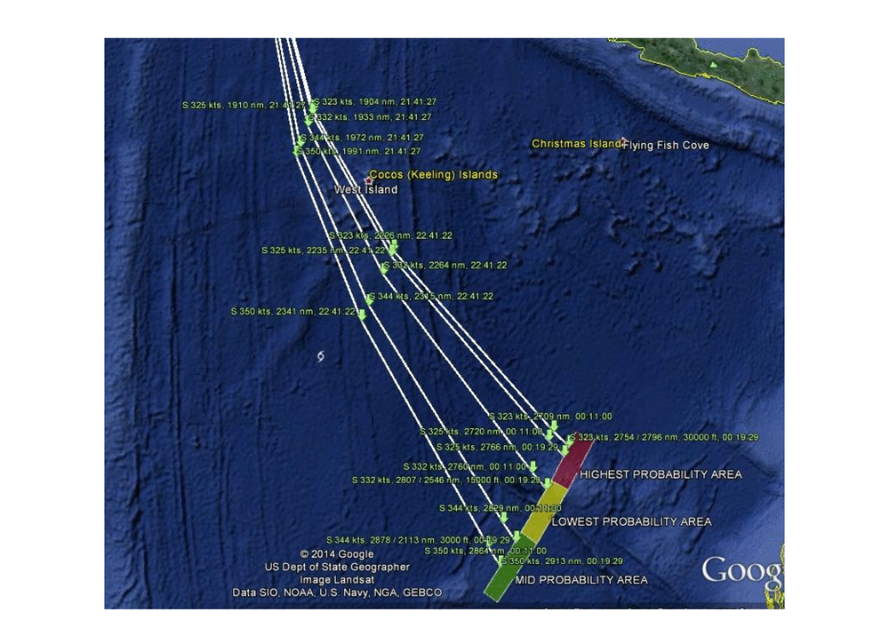
- The original documents were placed on the Malaysian Acting Minister of Transport's Facebook page. They appear to be jpgs there: I doubt that CNN have scanned them, probably just grabbed them from Facebook. I seem to remember reading somewhere that the Malaysians had emailed them to news organizations, but I can't find them at the places I would expect. Anyway, the best official source for the documents at the moment is the Malaysian Airlines website, where they are available as pfds (and hence probably better resolution) and are all available with separate URLs. Kulath (talk) 17:08, 9 May 2014 (UTC)
- In looking at the maps page 2 and page 3 it appears looked at five possible tracks:
- 323 kts at 30,000 feet
- 325 kts
- 332 kts at 15,000 feet
- 344 kts at 30,000 feet
- 350 kts
- If the altitude is stated for the 325 kts and 350 kts tracks then I missed it. --Marc Kupper|talk 21:24, 1 May 2014 (UTC)
- A couple of questions:
- Do the pings plot along a great circle line? What was the course if so?
- I'm not sure I understand the increasing path divergence. I assume it's about having fewer data points (pings) to extrapolate from, but
then the highest probability zone should be in the middle if so, shouldn't it?
walk victor falk talk 21:46, 1 May 2014 (UTC)
- Predominating westerlies, I presume? walk victor falk talk 21:48, 1 May 2014 (UTC)
- No, the pings did not plot along a great circle. They were derived from timed delays measured from a (notionally) geostationary satellite about 22,500 miles high, located on the equator, over the western Indian Ocean. Regards, Lynbarn (talk) 23:42, 1 May 2014 (UTC)
- Victor falk asked "Do the pings plot along a great circle line?" I have not tried. The maps shown are a map projection of some sort. It's quite possible that although the plots look curved to us that it's a straight great circle course. What we'd need to do is to first understand exactly which projection was used. From that we should be able to bend the map and to see if the line straightens out.
- The path divergence is because the aircraft speed and altitude were unknown. Estimates made of likely speeds and altitudes. It's not a completely wild guess as they have seven data points from Inmarsat and there's a limited number of potential courses that would fit with the data they have. I believe a large part of the estimate hinges on that an aircraft on autopilot will fly at a constant speed, altitude, and magnetic heading. The most easterly and shortest course would be if the aircraft cruised at 323 knots. The most westerly and longest course assumes a speed of 350 knots.
- I don't know why the probabilities for the zones are high, low, and then middle. I believe I read the focus was put on the northern portion based on some data that pointed to the aircraft flying slower but that does not explain why the middle zone is marked as low probability on the map. --Marc Kupper|talk 01:09, 2 May 2014 (UTC)
- Marc Kupper points out the middle area is labelled "low probality". I didn't noticed that, assuming yellow means "mid". Surely, they couldn't be mislabelled? The paths are, from west to east, in decreasing order of speed 350 kts, 344 kts, 332 kts, 325 kts, 323 kts. It seems either a higher or lower is considered more probable (and the lower most probable), with the middle speed (332 kts) least probable. walk victor falk talk 01:41, 2 May 2014 (UTC)
- Victor falk, I would suspect the labels are correct and that there's a factor that weighted the probabilities that either has not been announced or we read about it at some point over the past 40 days and did not understand at the time what it was important for. I think they needed three colors and used a pattern similar to a stop light. If the colors were intended to be meaningful then you'd think green would the high probability area.
- The paths are in order of increasing speed. 323 knots on top, then 325, 332, 344, and 350 knots in that order. At the end there are two arcs right next to each other, one for the ping at 00:11:00, and the second for the partial handshake at 00:19:29. The labels and arrows are a bit of a jumble but are still easy to read here. --Marc Kupper|talk 04:07, 2 May 2014 (UTC)
- @victor falk: I suspect the reason why the 332 kts is least probable, is because this scenario was calculated with an altitude down at 15,000 feet. Simply put, they do not consider that scenario likely, as the aircraft consume a lot more fuel per travelled kilometer at the lower altitudes due to increased air resistance, and when they compare those calculations with estimations of how much fuel was left in the aircraft tank (the moment ACARS stopped operating), then the aircraft is just considered to have been unlikely to have been flying at such a low altitude. Danish Expert (talk) 04:29, 2 May 2014 (UTC)
- @Marc Kupper: In regards of the 7 ping arc lines, Lynbarn posted the correct answer. They have been drawn simply based upon the measured time delay of the ping signal between the geostationary satellite and the aircraft. At each point of the curved arc-line you have the exact same distance to the satellite, which is why they say the aircraft at a certain time had a whereabout at some point of the calculated ping-arc lines. So they started out drawing the 7 known arc-ping-circles, which we have absolutely no uncertainty about. Then they did the frequency gap analysis (Doppler analysis) of the received signal, and figured out the aircraft due to the measured frequency loss of the signal could only have flown at a southern course. Then at step 3, they started to map a course line between the last observed military radar point and each "most likely arc-position" for the 7 pings (based on the best fit for the frequency loss calculated by the Doppler analysis). Then at step 4, they compared this drawn course line with how much fuel would be needed for such a travel - and assessed the likelihood for such a course under the assumption the aircraft ran out of fuel on exactly the time of the last 7th ping. The tricky point is, that for each calculation where you fix the aircraft speed and altitude to a certain value, then this affects the Doppler analysis (because the measured frequency gaps as per the equation depends on both speed+altitude and direction), which return a new specific result of the "most likely course/direction". So the output of the Doppler analysis is "the most likely course/direction" at the given 5 scenarios with fixed altitude + speed values. The technical team focusing on the fuel calculation, deemed the 15000 feet scenario unlikely on 28 March, simply because the fuel calculations showed the aircraft had not enough fuel left for such a scenario, and at the same time the calculated "impact area" was moved up from 40 degrees South to 30 degrees South because the "fuel technical team" concluded the aircraft did not carry enough fuel to have travelled such a long distance down to the forties. The technical team also presented a revised "impact area" calculation again on the evening of 2 April, moving it further up North to 21 degrees South (where we still are today). In regards of the latest 2 April revision, I have no sources telling me exactly on what grounds they moved it up again, but I suspect it was because of a "final assumption" that the aircraft was believed to have ran out of fuel on the exact time of the 7th partial ping, and when the "fuel technical team" reverse calculated based on that assumption combined with known data about the standard fuel consumption of the motors, they came up with a "travelled distance" that basically matched the "Inmarsat Scenario" resulting in an "impact point" at 21.1 degrees South and 104.0 degrees East. Danish Expert (talk) 04:29, 2 May 2014 (UTC)
- @victor falk: I suspect the reason why the 332 kts is least probable, is because this scenario was calculated with an altitude down at 15,000 feet. Simply put, they do not consider that scenario likely, as the aircraft consume a lot more fuel per travelled kilometer at the lower altitudes due to increased air resistance, and when they compare those calculations with estimations of how much fuel was left in the aircraft tank (the moment ACARS stopped operating), then the aircraft is just considered to have been unlikely to have been flying at such a low altitude. Danish Expert (talk) 04:29, 2 May 2014 (UTC)
- Marc Kupper points out the middle area is labelled "low probality". I didn't noticed that, assuming yellow means "mid". Surely, they couldn't be mislabelled? The paths are, from west to east, in decreasing order of speed 350 kts, 344 kts, 332 kts, 325 kts, 323 kts. It seems either a higher or lower is considered more probable (and the lower most probable), with the middle speed (332 kts) least probable. walk victor falk talk 01:41, 2 May 2014 (UTC)
- I don't know why the probabilities for the zones are high, low, and then middle. I believe I read the focus was put on the northern portion based on some data that pointed to the aircraft flying slower but that does not explain why the middle zone is marked as low probability on the map. --Marc Kupper|talk 01:09, 2 May 2014 (UTC)
- Danish Expert, I am not by any means wanting to cast doubt on what you say, you may well have your own sources to substantiate this, and it all sounds very reasonable. However I don't think there are any 'Wikipedia reliable sources' to say that is what happened. It is useful background, but we must be careful to only use information in the article that we can substantiate from published sources. Kulath (talk) 17:24, 9 May 2014 (UTC)
- Danish Expert, I knew Lynbarn's answer was correct but I had a different understanding of Victor Falk's questions and addressed that. I fully agree with what you wrote except the part about "deemed the 15000 feet scenario unlikely on 28 March." The preliminary report is dated April 8th and has 15,000 feet as of the estimated altitudes. It's possible the map that states 15,0000 feet was created before March 28th and not updated.
- Victor Falk, after my last message I realized there's another clue that the high, low, mid probability labels likely are correct. If you look at [cumulative search handout from April 6, 2014 you'll see they had canvassed the high and mid probability areas but not the low probability area. Whatever weighted those probabilities must have been significant enough that the section in the middle had not been grid-searched as of April 6th. --Marc Kupper|talk 04:54, 2 May 2014 (UTC)
- @Marc Kupper: OK, that explains. In regards of your note above, our map 3 of the preliminary report however claim the 344 kts course was at 3,000 feet and not 30,000 feet. If its not a typo, then your first theory about the "color heat" scale implying green = unlikely, yellow = perhaps, and red = likely (it keeps getting hotter), could however be true. In that case map 3 just accidently mislabeled the colors. To me it doesn't make any sence if they believe a 3000 feet course is more likely compared to a 15000 feet course. I look forward to learn what is really up and down about this map. Please continue your great hunt for the correct answer. :-) Best regards, Danish Expert (talk) 05:15, 2 May 2014 (UTC)
- @Marc Kupper: Sorry, please disregard my reply above. It was too darn early in the morning for me too read and understand the map. After a second look, what it intend to say about the tree courses we discuss is:
- 323kts => 2754 nautical miles (~2796nm at 30000 feets, meaning 1.5% longer at that altitude)
- 332kts => 2807 nautical miles (~2546nm at 15000 feets, meaning 9.3% shorter at that altitude)
- 344kts => 2878 nautical miles (~2113nm at 3000 feets, meaning 26.6% shorter at that altitude)
- The parenthesis only show how the calculated course distance is, when converted to another altitude compared to the one they believe the aircraft flew at. Based on the given figures it can be extrapolated (if I understand this correct), that they apparently believe the aircraft flew its last 2754/2807/2878 nautical miles at an altitude of 28000 feets. We should not read anything into the parenthesis figures. I believe all 6 drawn courses for various speeds were drawn for the same 28000 feets altitude. In regards of the three colored impact area, then I can reveal the entire area with all three colors is only around 700km x 80km. So all three only deal with the "final impact area" calculated in the evening of 2 April, in which both Haxiun and Ocean Shield picked up acoustic recordings, and where JACC by the way now has decided to do a complete side-scan sonor mapping of the seabed. None of the premature incorrect courses calculated ahead of 2 April (ending respectively at 30 degrees South and 40 degress South) are displayed by the map in the preliminary report! Danish Expert (talk) 06:33, 2 May 2014 (UTC)
- I missed that the last track was 3,000 feet. That implies JORN never spotted MH370. The Operation and uses section of that article claims spotting a Cessna 172 taking off and landing in East Timor 2600 km away. Did they miss a 777 cruising along 1,500 km from the coast?
- I need to think more about what you wrote. I was also looking at the numbers after the slash for 00:19:29. The lines of interest are:
S 323 kts, 2754 / 2796 nm, 30000 ft, 00:19:29S 332 kts, 2807 / 2546 nm, 15000 ft, 00:19:29S 344 kts, 2878 / 2113 nm, 3000 ft, 00:19:29
- My guess is the 2796, 2546, and 2113 are the estimate range at that altitude. The air is thicker at lower altitudes and so you burn more fuel. It seems the preliminary report was redacted more than is apparent as they likely would explain the numbers in the report.
- Do you have a source for 28000 feet? --Marc Kupper|talk 17:19, 2 May 2014 (UTC)
- @Marc Kupper:No source. It was just me playing around, simply calculating what the altitude of the 3 routes needed to be, if we assume the noted travel distance of the flight at various altitudes is indeed 100% correct. In that case we end up with having a flight altitude at 28000 feet - matching the calculated fuel travel distance range. I assumed the same as you, that the second noted distance was the "calculated fuel travel distance range at various heights" not being route specific. Meaning that they could and should, just have written this separate line:
Calculated fuel range: 2796 nm at 30000 ft / 2546 nm at 15000 ft / 2113 nm at 3000 ft.
- However, I am not sure about anything here. Just guessing. Only thing I am sure about, is that the second nautical mile figures have nothing to do with the increased air-distance travelled if you run the route at a 10km higher altitude. Knowing that the flight 370 only traveled a distance roughly equal to 10% of the earths equator distance, then the difference in line-distance when flying at a point 6388km from the center core of the earth - compared to 6378km from the center core of the earth, only make up for a distance increase equal to 5 nautical miles. We can calculate that as a fact by C=2πR. :-) Danish Expert (talk) 14:47, 3 May 2014 (UTC)
- @Marc Kupper:No source. It was just me playing around, simply calculating what the altitude of the 3 routes needed to be, if we assume the noted travel distance of the flight at various altitudes is indeed 100% correct. In that case we end up with having a flight altitude at 28000 feet - matching the calculated fuel travel distance range. I assumed the same as you, that the second noted distance was the "calculated fuel travel distance range at various heights" not being route specific. Meaning that they could and should, just have written this separate line:
- @Marc Kupper: Sorry, please disregard my reply above. It was too darn early in the morning for me too read and understand the map. After a second look, what it intend to say about the tree courses we discuss is:
- @Marc Kupper: OK, that explains. In regards of your note above, our map 3 of the preliminary report however claim the 344 kts course was at 3,000 feet and not 30,000 feet. If its not a typo, then your first theory about the "color heat" scale implying green = unlikely, yellow = perhaps, and red = likely (it keeps getting hotter), could however be true. In that case map 3 just accidently mislabeled the colors. To me it doesn't make any sence if they believe a 3000 feet course is more likely compared to a 15000 feet course. I look forward to learn what is really up and down about this map. Please continue your great hunt for the correct answer. :-) Best regards, Danish Expert (talk) 05:15, 2 May 2014 (UTC)
Fair use of maps
Unless I missed something, there are no coordinates for the positions plotted on map pages 2-3 (except the yellow pins). This is a substantial piece of information in the investigation and search and without coordinates, not possible to recreate. I think a map created by merging the maps on the two pages should be added to the article, either: 1)replacing the arc corridor map at the beginning of the "search" section or 2) placed in the "investigation" section. Thoughts on placing a map (as fair use) in the article merged from the two in the report (map pages 2-3)? AHeneen (talk) 05:39, 3 May 2014 (UTC)
- The maps are not to the same scale meaning they can't just be spliced together. It appears whoever created the maps used Google maps rather than rather than commercial navigation tools. That means the map background is copyright Google and/or the entities that supplied data to Google. I believe for purposes of the encyclopedia that we should recreate this map. There are many maps on Australia that cover the general region. I have not looked but assume many or all of them are public domain works.
- The satellite's position has been reported. The next to last or possibly the last arc is known to be at 40 degrees meaning it can be drawn with decent accurately. The angles for the other arcs have not been reported. It should be possible to estimate them from maps 2 and 3. In the lower/right corner of map 2 is "1812'12 77" S 05812'58 52" E alay?1". That appears to be the position of the satellite. The "alay?1" part is a guess as the lower part of this line is truncated. --Marc Kupper|talk 16:47, 3 May 2014 (UTC)
- I took a look at the slightly larger version of map 2 and decided the string in the lower-right corner is not relevant. It seems to be "1°12'13.77" S, 95°12'58.52 E" (Google map) and likely was the mouse cursor at the time they did the screen shot. --Marc Kupper|talk 19:57, 4 May 2014 (UTC)
- File:Zenith Plateau Flight 307 Pings 002.png is an example of a Wikipedia constructed map that I'm thinking of. This map has the arc for the 7th handshake meaning the person who made the map may have the raw data for that arc. --Marc Kupper|talk 17:10, 3 May 2014 (UTC)
- Btw, does anyone have a source(s) for the coordinates of the ping area? They are not mentioned anywhere in the article now. (25S 101E is for the Haixun ping) walk victor falk talk 18:53, 3 May 2014 (UTC)
- I think the preliminary report maps were the first time we ever saw anything about where the other arcs were. The public version of the preliminary report seems to have a lot of data redacted including explanations of the maps and the coordinates. The best we can do is to extract the coordinates from the maps. For example I started a browser session with map 3 in one tab and Google maps in another tab. I then found with one click of zoom reduction of map 3 that I could superimpose both Cocos Island and Christmas Islands. I clicked Ctrl-tab to toggle between the two maps. Once I had them lined up. I put the mouse cursor at the point of a green arrow on map 3, toggle to Google, right click, and select "What's here?". Google tells me the latitude/longitude. This list has from top down in the times and from fastest to slowest within each time. What I don't know how to do is to put all of those values on a single map.
- 18:27:04 7°15′13″N 95°16′11″E / 7.253496°N 95.269775°E (from map 2)
- 19:41:03 0°21′06″N 93°09′37″E / 0.351560°N 93.160400°E (from map 2)
- 20:41:05 5°54′01″S 93°10′57″E / 5.900189°S 93.182373°E 5°47′27″S 93°14′54″E / 5.790897°S 93.248291°E 5°19′54″S 93°20′10″E / 5.331644°S 93.336181°E 5°02′50″S 93°24′08″E / 5.047171°S 93.402099°E (from map 2)
- 21:41:27 11°12′00″S 94°18′11″E / 11.199957°S 94.302978°E 10°51′18″S 94°26′05″E / 10.854886°S 94.434814°E 10°08′31″S 94°41′55″E / 10.141932°S 94.698486°E 9°45′09″S 94°52′27″E / 9.752370°S 94.874267°E 9°38′39″S 94°55′06″E / 9.644077°S 94.918212°E (from map 3)
- 22:41:22 16°43′13″S 96°32′39″E / 16.720385°S 96.544189°E 16°12′53″S 96°45′50″E / 16.214675°S 96.763916°E 15°10′41″S 97°16′09″E / 15.178181°S 97.269287°E 15°10′41″S 97°16′09″E / 15.178181°S 97.269287°E 14°20′58″S 97°39′53″E / 14.349548°S 97.664794°E (from map 3)
- 00:11:00 24°00′23″S 100°53′41″E / 24.006326°S 100.894775°E 23°14′29″S 101°25′20″E / 23.241346°S 101.422119°E 21°35′46″S 102°24′39″E / 21.596151°S 102.410888°E 20°36′44″S 102°58′56″E / 20.612220°S 102.982177°E 20°16′58″S 103°09′29″E / 20.282809°S 103.157959°E (from map 3)
- 00:19:29 24°41′13″S 101°18′44″E / 24.686952°S 101.312255°E 23°50′44″S 101°51′42″E / 23.845650°S 101.861572°E 22°11′15″S 102°54′59″E / 22.187405°S 102.916259°E 21°07′32″S 103°31′53″E / 21.125498°S 103.531494°E 20°47′50″S 103°42′26″E / 20.797201°S 103.707275°E (from map 3)
- Someone with the right software likely can do a more exact job of extracting where those arrows point. --Marc Kupper|talk 04:39, 4 May 2014 (UTC)
- I found that this link will show all the coordinates on this talk page. --Marc Kupper|talk
- But isn't that original research? The report is the first and only source that shows the locations of the other handshakes. It is more appropriate to upload a map stitched together from the two pages and add to the article as fair use rather than attempt to create any interpretations of it. AHeneen (talk) 02:47, 5 May 2014 (UTC)
- I believe it's not WP:OR per "To demonstrate that you are not adding OR, you must be able to cite reliable, published sources that are directly related to the topic of the article, and directly support the material being presented." I'm taking data directly from a WP:RS map. I'm not engaged in WP:SYNTH with regard to that data. I've also documented the process I used as part of verifiability and also to see if someone has a better process in mind. I do not believe we can use the maps released under WP:FAIRUSE per "Non-free content should not be used when a freely licensed file that serves the same purpose can reasonably be expected to be uploaded." The stuff that's copyright on those maps is the background. We have public domain backgrounds available and so it's a matter of putting the dots and lines on them. I am not proposing that we publish the coordinates I listed above in the article. The list of coordinates only exists to serve in making a (nearly) freely licensed map.
- But isn't that original research? The report is the first and only source that shows the locations of the other handshakes. It is more appropriate to upload a map stitched together from the two pages and add to the article as fair use rather than attempt to create any interpretations of it. AHeneen (talk) 02:47, 5 May 2014 (UTC)
- I think the preliminary report maps were the first time we ever saw anything about where the other arcs were. The public version of the preliminary report seems to have a lot of data redacted including explanations of the maps and the coordinates. The best we can do is to extract the coordinates from the maps. For example I started a browser session with map 3 in one tab and Google maps in another tab. I then found with one click of zoom reduction of map 3 that I could superimpose both Cocos Island and Christmas Islands. I clicked Ctrl-tab to toggle between the two maps. Once I had them lined up. I put the mouse cursor at the point of a green arrow on map 3, toggle to Google, right click, and select "What's here?". Google tells me the latitude/longitude. This list has from top down in the times and from fastest to slowest within each time. What I don't know how to do is to put all of those values on a single map.
- I used "(nearly)" above as I believe the placement of the arrows is copyright. Copyright law has a concept known as "sweat of the brow" to determine if something is copyright. The work that went into figuring out the arrow placement seems to qualify them as copyright. However, it would be impossible, and certainly WP:OR, for us to independently arrive at our own arrow placement. We would be allowed to WP:FAIRUSE the arrows as we are unable to come up with a freely licensed version of them. --Marc Kupper|talk 05:59, 5 May 2014 (UTC)
I have to go with Marc Kupper here. One pinning RS coordinates onto a publicly available map isn't *quite* synthesis and isn't OR. If we adopted that route, even a pin in a paper map would be a copyright violation and much of the available information that is public domain would be off limits. What it is, in my own opinion, is enhancing the value of a PD map with information from RS on a current event that will likely be historically notable.Wzrd1 (talk) 06:16, 5 May 2014 (UTC)
preliminary report
The preliminary report can be found in pdf here: http://www.malaysiaairlines.com/content/dam/mas/master/en/pdf/MH370%20-%20Preliminary%20Report.pdf MAS also provide links to the other components released with th ereport such as audio of ATC/pilot comms: http://www.malaysiaairlines.com/my/en/site/mh370.html Opal2 (talk) 13:20, 4 May 2014 (UTC)
- Thank you. The http://www.malaysiaairlines.com/my/en/site/mh370.html URL is not stable. You will need to click the 1, 2, 3, etc. at the bottom of the page to find a particular announcement. Of interest is the announcement with the title "Thursday, May 01, 07:00 PM MYT +0800 Media Statement 29 by Ahmad Jauhari Yahya, Group Chief Executive Officer, Malaysia Airlines". At present it's on page 2 but will be shifted down to page 3, 4, 5, ... as new announcements get added to the site. The announcement about the preliminary report has an introduction from the airline and then links to ten attachments which were the items that had been made public on 1 May 2014:
- 1. ATC Delivery .wav file audio
- 2. KL Ground .mp3 file audio
- 3. KL Tower .mp3 file audio
- 4. KL Approach .mp3 file audio
- 5. KL Radar .wav file audio
- Actions taken between 0138 and 0614
- Cargo Manifest and Airway Bill
- Maps
- Preliminary Report
- Seating plan
- I extracted the images from "MH370 - Maps.pdf" and found they were slightly larger than the ones CNN had made available. For example, while CNN has a 788x635 pixel map 2 the PDF has 835×671 and 1135×913 pixel version of the same map. That'll allow for more accurate estimation of the placement of the arrows. --Marc Kupper|talk 18:48, 4 May 2014 (UTC)
Search
the search information claims the pings registered "were consistent with the specification and description of a flight data recorder ULB". the source given however merely expresses the search peoples opinion. the specification is NOT the same, and this sentence is clearly false and misleading. the blackbox frequency is 37.5 and the range not more than 2.3 km, NOT consistent with the heard pings a lot more apart and lasting longer than it should on moving ships. Please check the facts and remove this sentence. — Preceding unsigned comment added by 72.211.204.220 (talk) 04:49, 8 May 2014 (UTC)
- All we can do is record what is reported elsewhere; if someone says the signals were consistent, then that's what the article says. A qualifier could be added "an official stated..." if there isn't already such - I haven't looked. YSSYguy (talk) 04:58, 8 May 2014 (UTC)
you need to stick with the truth. surely wiki cannot present false speculations as fact! the same way georesonance rubbish isnt presented as fact. doesnt matter who makes the speculations. — Preceding unsigned comment added by 72.211.204.220 (talk) 08:43, 8 May 2014 (UTC) I made the changes to reflect the fact that it was "claimed" to be consistent with the black box pinger, and added there were other problems with identifying the pings as coming from the black box, and a reference. Also changed the depth of the first and second detections to the correct ones -- the first went on for 2 hours 2o minutes with the TPL fully deployed at 3000m; it was the second one that was brief, with the TPL hardly in the water! 112.118.233.194 (talk) 13:21, 9 May 2014 (UTC)
I don't think that is right. According to http://www.navy.mil/submit/display.asp?story_id=80169 there were three detections:
(a) at a depth of 300 meters,
(b) at 1,400 meters for two hours,
(c) at 3,000 meters for 15 minutes (two pings detected).
I haven't found any other reference to the depth at which the pings were detected. Kulath (talk) 17:36, 9 May 2014 (UTC)
Timeline
The timeline includes the following item: "01:34 02:15 18:15 Last primary radar contact by Malaysian military, 200 miles (320 km) NW of Penang". Indications are that this information about the plane's radar trace was deduced from analysis of the radar record after the event. Putting it in the timeline implies something happened at 02:15, when nothing actually happened. Should it be removed from the timeline?Opal2 (talk) 11:24, 10 May 2014 (UTC)
Taiwanese (and Chinese) media report that black boxes were found
This page in Mandarin http://www.life.com.tw/?app=view&no=125975 asserts that black box from this flight was found by "Chinese People's Liberation Army". They also tell the story that the pilot contacted Malaysian government while in flight, and put forward some political demands. He threatened to kill all passengers, etc. Government refused tocooperate, and was hiding this information. Article goes on and on, it has the photo of the black box itself. And this wiki page says nothing about this at all. Does this mean that this is completely false information for local (Chinese) consumption? Or there is some truth to it? Yurivict (talk) 04:24, 14 May 2014 (UTC)
Map illustrates poorly
The map File:Map of search for MH370.png is inferrior to http://theaviationist.com/wp-content/uploads/2014/03/Search-MH370-WaPo.jpg from the The Aviationist. Improvements to make:
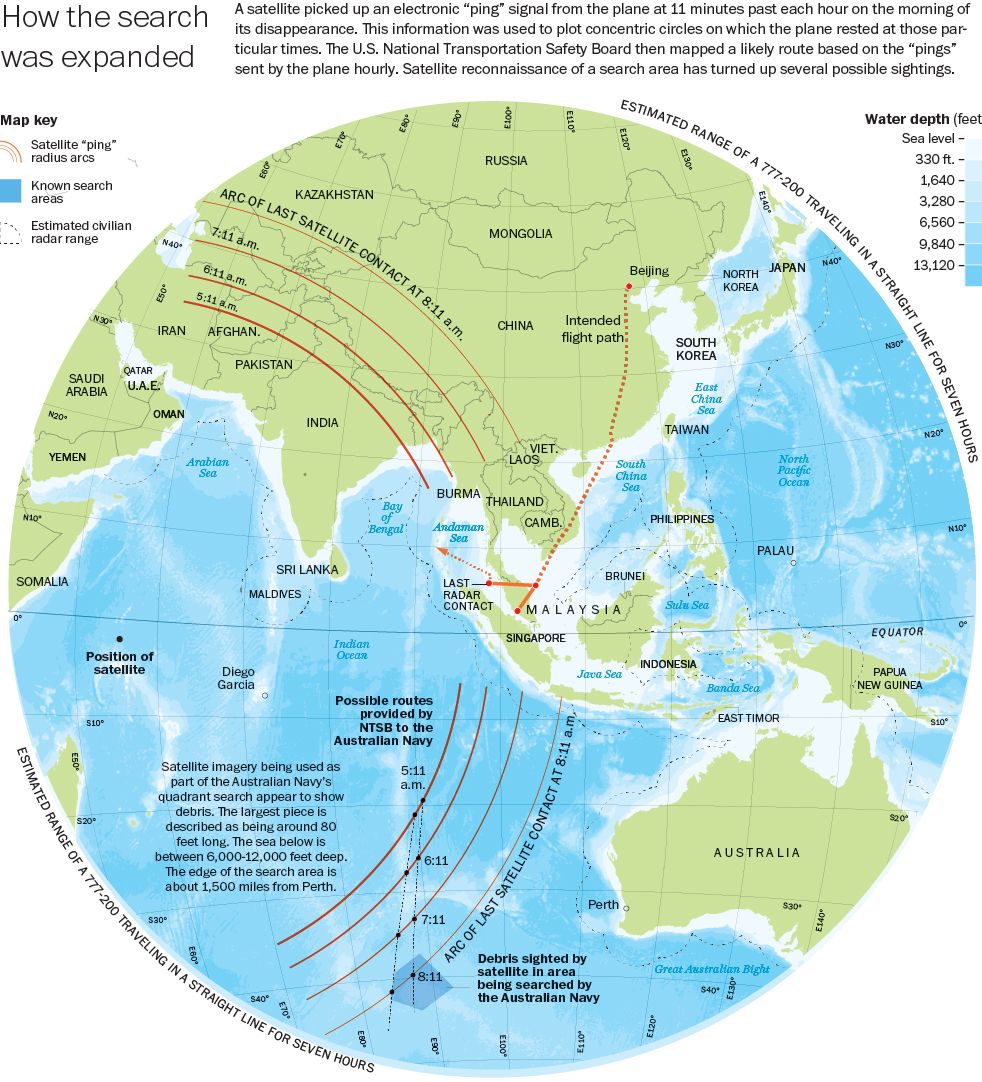
- Crop Africa out; Its irrelevant and serves to only make the picture smaller
- Show more than just the last ping
- Show the radar path + Estimated radar range
- More labels: Transponder turned off 00:00, Last voice contact 00:00, Last Radar Contact 00:00
- Use better colors :-)
--68.36.63.8 (talk) 00:48, 13 May 2014 (UTC)
- There is no evidence that this map is reliable. I strongly suspect that the ping rings shown on this map are simply illustrative of the sort of thing that the other ping rings might show. They have absolutely no authority or validity as to their position. (At the time the Washington Post was putting this sort of thing out, there were several other sources that presented illustrative maps.) Kulath (talk) 17:36, 16 May 2014 (UTC)
Passenger manifest updated by Malaysia Airlines 10 Apr
There was an updated passenger manifest published by Malaysia airlines on the 10th of April 2014. It differs from the original in the following way: Passenger 213 ZHANG/YAN Age 2 American of the original list is removed Passenger 104 MENG/NICOLECHD is corrected in the manifest of 10th of April as MENG/NICOLE Age 4 American is given number 105 on the later manifest and MENG/LEO Age 2 American is inserted as a new passenger and is given number 104 Underwaterlunch (talk) 08:02, 16 May 2014 (UTC) [1]
- Unconfirmed (please, what source?). Current source (DCA official newsroom)
PauloMSimoes (talk) 10:11, 16 May 2014 (UTC)
Up until 11/04/14 This site http://www.malaysiaairlines.com/my/en/site/dark-site.html was active. Now showing as a 404 error and redirecting, it provided both the earlier manifest and the updated manifest on 10/04/14 both as official documents. I have both the earlier manifest and updated manifest as .pdf files. where is the appropriate place to upload these ? Underwaterlunch (talk) 06:25, 17 May 2014 (UTC)
- The site is a primary source with no track record of durability. It's about as good or bad as anything else the Malaysians have done to date. We need to find an external RS to back up that information. And there should be plenty of those. -- Ohc ¡digame! 07:59, 17 May 2014 (UTC)
A site has been established here:Cite error: There are <ref> tags on this page without content in them (see the help page). http://mapminfo.wordpress.com providing passenger manifest informationUnderwaterlunch (talk) 10:02, 17 May 2014 (UTC)Underwaterlunch (talk) 10:45, 17 May 2014 (UTC)Underwaterlunch (talk) 10:53, 17 May 2014 (UTC)
- Google searches for a reliable source for an updated passenger manifest haven't been successful, but I did find the 10 April 2014 PDF here: http://www.malaysiaairlines.com/content/dam/mas/master/en/pdf/Malaysia%20Airlines%20Flight%20MH%20370%20Passenger%20Manifest_Nationality@10Apr.pdf . Malaysia Airlines has disabled most of the navigation functions on their site, so I can't find any clues as to why there are differences between the two versions of the manifest. Reliable sources dated as far back as 8 March do mention "Leo Meng", age 2, apparently based on an early version of the manifest that was leaked to a Chinese website: see http://www.telegraph.co.uk/news/worldnews/10685436/Malaysia-crash-victims-and-tears-of-their-families.html and http://www.dailymail.co.uk/news/article-2576641/Terror-fears-missing-777-grow-Identities-ANOTHER-two-passengers-probed-suspicion-falls-four-booked-Chinese-airline.html . But still no RS for the second version of the passenger manifest. NameIsRon (talk) 15:52, 17 May 2014 (UTC)
- For what it's worth, here's a copy of the seating plan for MH370, as archived by the Wayback machine in case it's later removed from the airline's website. NameIsRon (talk) 18:31, 17 May 2014 (UTC)
Satellite pings - signal source
Would it be difficult to copy and reproduce the ping-signal and the handshake from a second device on a different aircraft or is it unique and protected by some encryption? Slowlate (talk) 19:09, 17 May 2014 (UTC)
- See WP:NOTFORUM. AndyTheGrump (talk) 19:51, 17 May 2014 (UTC)
Template
In case anyone is interested: Template_talk:Aviation_accidents_and_incidents_in_2014#MH370. Brandmeistertalk 14:54, 22 May 2014 (UTC)
Malaysia releases satellite data
This New York Times article is from the AP feed and says "The Malaysian government has released 47 pages of raw satellite data used to conclude that the missing Malaysia Airlines jet crashed into the southern Indian Ocean." The article did not link to the data itself. I checked the sites listed in the external links section of this WP article but none of those sites have the the newly released data either. Has anyone seen it? --Marc Kupper|talk 05:04, 27 May 2014 (UTC)
- The data release can be found at [10]. None of the news articles on the topic seem to provide the link, for some reason. 130.216.218.47 (talk) 05:27, 27 May 2014 (UTC)
- Sincere thanks to Marc and to 130.216.218.47. Curiously the report containing the data is neither signed nor time-stamped. For some reason. — Preceding unsigned comment added by 195.191.133.242 (talk) 05:51, 27 May 2014 (UTC)
- Thank you 130.216.218.47. The "MH370 Data Communication Logs.pdf" date/time stamp is May 27, 2014 11:05:37 AM MYT (UTC+8 hours) or May 27, 2014 03:05:37 UTC. The PDF properties has:
- Created: May 23, 2014 9:05:09 AM
- Modified: May 27, 2014 11:05:37 AM
- As the Modified time stamp matches the MYT time from the download we'll assume the created time is also MYT. CNN now has the same file[11] but it was uploaded about 2.25 hours after the version on www.dca.gov.my.
- Some good news:
- The ping resolution seems to be +/- one microsecond though they do not state if that is the resolution. It's late for me and so I don't feel up to the math to see how much error that adds to the width of the arc.
- They document the components of the round trip. I'd mentioned the components before but that was based on personal experience. Now we have a WP:WS.
- Some bad news:
- I was hoping this report would have the latitude/longitudes for the estimated positions on the arcs. There was an earlier discussion where I had estimated the latitude/longitudes by eyeballing them off maps that had been released. Thus, we have the raw data investigators used but none of the additional data, such as on the aircraft's estimated altitude, fuel burn, the BTO values for other aircraft in the area, etc. they had gathered nor the results. They are failing to "show the math" to use a regular refrain from mathematics instructors.
- It does not explain the link idle/logon logic. The Inmarsat terminal had responded to hourly queries at 18:14, 19:41, 20:41, 21:41, and 22:41. (PDF page 40). You'd assume the next logon (ping) would be at 23:41. I don't see that mentioned anywhere in the report. I had made the assumption they they transmitted and when they got no response they scheduled a retry for 30 minutes later. This is not documented in the report. Instead they jump to 8 March 00:10:58 where they transmit and receive a response. 00:10:58 is exactly 30 minutes after the missing ping. Maybe their standard logic is hourly pings for a while, and then every 90 minutes for a while, and then longer intervals.
- The bottom of page 41 shows three handshake requests with no response. They were sent at 01:15:56, 01:16:06, and 01:16:15. This makes sense. The response is normally received in two seconds. Inmarsat must be giving them ten seconds and then retrying twice. The time these were sent, starting at 01:15:56 is unexpected.
- They do not document the ground station used. I know it's in Australia but wanted a WP:RS.
- The report gives people a list of Burst Frequency Offset(BFO) and Burst Timing Offset (BTO) values without context. Interpretation of these values requires context. --Marc Kupper|talk 08:32, 27 May 2014 (UTC)
- Considerations On Defining The Search Area from the ATSB shows the ground station in Perth on page three. Kind of bizarre, really, that the search was being coordinated in the same city where the satellite messages were received. Mark Grant (talk) 01:44, 28 May 2014 (UTC)
- I suspect all we can add to the WP article is that the raw data was released. --Marc Kupper|talk 08:32, 27 May 2014 (UTC)
- As the source PDF had copy/paste disabled I exported it and have saved the data as a spreadsheet here for those that are interested. One issue is that Google Docs does not support fractions of a second when formatting the date/time. I decided to add that as a separate column. --Marc Kupper|talk 21:21, 27 May 2014 (UTC)
- Thank you 130.216.218.47. The "MH370 Data Communication Logs.pdf" date/time stamp is May 27, 2014 11:05:37 AM MYT (UTC+8 hours) or May 27, 2014 03:05:37 UTC. The PDF properties has:
- Sincere thanks to Marc and to 130.216.218.47. Curiously the report containing the data is neither signed nor time-stamped. For some reason. — Preceding unsigned comment added by 195.191.133.242 (talk) 05:51, 27 May 2014 (UTC)
Analysis of satellite communication
Can we have the passage referring to the 8th of May article removed? Given the more detailed satellite data released via official channel on the 27th of May, the analysis in the article appears to be misguided because it incorrectly assumed the frequency shifts were observed at the satellite instead of the ground station. The article's analysis also did not take into account equipment frequency bias or automatic Doppler correction by the communication system, which are noted in the official document. It feels to me that this entry is now fueling unnecessary speculations.78.147.0.112 (talk) 16:56, 28 May 2014 (UTC)
Is this of significance to be included - or too early to be encyclopaedic content?
Just came across "Indian Ocean acoustic data could yield clues about MH370" on flightglobal.com. Opening line is "A team of Australian researchers recorded an unusual acoustic event around the time Malaysia Airlines flight MH370 would have crashed owing to fuel exhaustion. The signal was detected by underwater acoustic sensors 40km off Australia’s Rottnest Island at 01:30 GMT on Saturday 8 March" GraemeLeggett (talk) 12:03, 4 June 2014 (UTC)
- Sorry, I already added it. No strong view, but sounded like a world first. Martinevans123 (talk) 12:46, 4 June 2014 (UTC)
Tightening up the text
The Disappearance section presently reads as follows: From there, the aircraft flew towards a waypoint called GIVAL, arriving at 2:15 local time (18:15 UTC, 7 March), thereafter to the Southern Thailand Islands (Andaman Coast) of Phuket, and was last plotted heading northwest towards another waypoint called IGREX.[26][27][28] Am I correct in thinking it should actually read: From there, the aircraft flew towards a waypoint called GIVAL, arriving at 2:15 local time (18:15 UTC, 7 March), thereafter towards the Southern Thailand Island (not islands) (Andaman Coast) of Phuket, and was last plotted heading northwest towards another waypoint called IGREX.[26][27][28]Roundtheworld (talk) 14:59, 4 June 2014 (UTC)
GeoResonance again
Ignoring earlier discussions, [12] it appears that a contributor is insistent that [13] we promote the pseudoscientific claims of a self-proclaimed 'land and sea survey company' that until recently was promoting 'Holistic Healing' rather than surveying, [14] despite the fact that they didn't at any point in time claim to have found Flight 370, and despite the complete lack of evidence that they have found anything, or indeed have the technology to do so. Given that this promotional trivia is of no more significance than all the other psychic woo and general bullshit that this incident has generated, I suggest that it be omitted, on the basis that this is an encyclopaedia, not a collection of random puffery. AndyTheGrump (talk) 19:48, 17 May 2014 (UTC)
- That contributor is me, and I've just started a section below this one explaining what happened to me and why I think it should be kept. I was unaware of the earlier discussion you've pointed out. From the many editors that have undone my edit in the last 17 days, three of them in the last 24 hours, I haven't seen a single one that had pointed out that discussion (and I'm obviously not reading through all the 10 archives of this talk page!—No, seriously! I'm amazed at how much discussion there has been in just two months! How do you guys have time to write all that?), so I guess you can't blame me for that. I honestly still don't see much problem with keeping it, since there is a whole lot more of other pseudoscientific claims that were made without evidence and resulted in nothing, and that are in the table. I honestly feel like you're attacking my work for no reason. Surely, I'm still getting used to Wikipedia, and I'm still learning, but (as I've stated before) it took me over an hour to do that. And if you're curious, most of that time was spent figuring how to use the reference template to tell you where I got that information from (which can be considered to be the most important part, since it proves I'm not lying). So please be kind and comprehensive. I'd appreciate that. Well, that's why I think it should be kept. Please, share with us your opinions too, so we can reach a consensus. Thanks! -- Sim(ã)o(n) * Talk to me! See my efforts! 20:37, 17 May 2014 (UTC)
- Not to be confused with these guys, of course. Martinevans123 (talk) 15:46, 4 June 2014 (UTC)
Versions of the Malaysia Boeing crash
Only one version of the Boeing crash has no the internal contradictions - Flight 370 met the atmospheric plasmoid. All details can be found in the paper: Boris V. Alexeev,"Some mysterious catastrophes of the last hundred years 188.123.241.130 (talk) 07:23, 7 June 2014 (UTC)from the point of view of non-local physics", Vestnik MITHT,N2, 2014.
of all time
"of all time" sounds not very encyclopedic. Since when does the editor knows that no deadlier incident happens? The information should be dated. 87.78.28.164 (talk) 08:01, 7 June 2014 (UTC)
- "yet" might be better.--Auric talk 10:20, 7 June 2014 (UTC)
- It's now three months on and that paragraph still uses "would be". Martinevans123 (talk) 10:26, 7 June 2014 (UTC)
GeoResonance claim: too much information?
Hello! On 30 April, I made an edit adding two news articles to the timeline of events of this page about the recent claim by GeoResonance that they had found wreckage to the south of Bangladesh (on 29 April) and JACC's response to it (on 30 April). However, it seems that my edit has been undone a few times. The last time it happened was in this edit, where its author wrote in the edit summary "bold removal of cynical promotion - this was nothing and has come to nothing". I undid their edit, stating "Ooh! There is so much more info here that has also resulted in nothing! The debris images? The oil slick? Perhaps a few others? Shall we remove all that too?". In other words, my edit seems to be no exception to the already-existing news that meant nothing in the end. Then why were they only destroying my work? Not to boast myself, but I wasted over an hour with that edit. I'd appreciate it if someone could be nicer and present a better justification. Then I got angry when someone undid my edit again, saying it was a "promotion of complete bull****", and I undid theirs again. Yet I was basically engaging in an edit war, which is never good.
So now I want to talk about this here. What do you guys think? Should we remove that or not? I mean, if GeoResonance's claim actually is, using someone else's term, bull-'something', then there is a lot more of bull-'something' in the rest of the table. I honestly think we should keep it, at least until we decide to do an overall clean-up of that table. Please give your opinions! Thanks!
(By the way, I just don't like to use of swear words; that's why I've censored that comment. I hope you're OK with it...) -- Sim(ã)o(n) * Talk to me! See my efforts! 20:13, 17 May 2014 (UTC)
- Read my comments in the section above. AndyTheGrump (talk) 20:18, 17 May 2014 (UTC)
- I have. I get your point: they seem to be an unreliable source. However, this was a piece of information worthy of, at least, two news articles. I'm not sure we really should delete it, though. You do make good points. They never said they'd found the flight. However, that could be applied to other stuff on the table. You also say there's no evidence that they've found anything at all, or that they have the technology to do so. Well, this news article seems to explain what they found, so I guess it's not true they didn't find anything. I'm still not too convinced. Yet I'll agree on keeping it out for a few days until a consensus can be reached. Let's just wait for a few more opinions, shall we? -- Sim(ã)o(n) * Talk to me! See my efforts! 22:01, 17 May 2014 (UTC)
- Sim(ã)o(n) I know you wrote this in good faith and I did think very hard before reverting your edits for some of the reasons you state. The pertinent bit of my edit summary was "this was nothing" and I stand by that statement - all the evidence I can find points to this being a scam of the most cynical and troubling kind with nothing to add to the search for the lost aircraft. This sort of thing many people, including me, find truly reprehensible, dishonest and rightly dangerous (like all the myriad of claims of psychics and similar pseudo-scientific practitioners to find lost children, loved ones or lost aircraft). I find the fact that you seem to be objecting to the fairly normal word "bullshit" (maybe this is a cultural difference) but you do not appear to be moved by the questionable motives of GeoResonance rather strange.
- My second point in my edit summary was intended to mean, its been several weeks since this came up and after a brief flash of interest by the press it has rightly been put in the too weird basket, no plane has been found in the exact place it was supposed to be which adds to the conclusion that it was nothing worthwhile mentioning in the first place.
- As an aside I find it rather interesting that this disappearance has highlighted, to me at least, a considerable ignorance of the limits to and application of technology and scientific laws. It is evident that people do not realise that cell phones need cellphone towers to work and there are not many of these away from populated areas. Are these the same people that accept without question that you can find copper wiring and jet fuel in a sunken aircraft from simple aerial photographs and imaging.Andrewgprout (talk) 23:29, 17 May 2014 (UTC)
- Well, thank you for having considered not to remove my contribution before you did it. I actually feel better now. I haven't investigated the credibility of GeoResonance (nor am I too interested in doing it—I'd rather take your word for it). Maybe you are right, and it would be kind of pointless to keep this information. But let me point that it's not the only thing in the table that is nothing and that has come to nothing; the same thing applies to the satellite images of debris (which turned out to be nothing but trash—literally), or to that oil slick (which was found to be unrelated), or to perhaps a few others I can't remember. It does seem to have caught the attention of the press for a while. Yet, as far as I've heard, it's a hypothesis that is not yet completely ruled out, since I haven't so far heard of any evidence that has proven or disproven that theory. Based on that, I still think it wouldn't be a bad idea for this information to be kept—at least, until someone finds out that this hypothesis was not true, or until we decide to do a general clean-up of that table, in order to delete everything that was confirmed to be nothing, like the debris satellite images or the oil slick. However, given that it seems like there's no-one else to support me (which means I'm likely to be wrong), I will agree on leaving that information out until someone supports me on my opinion, and thus gives a little more credit to it. If that doesn't happen, that information shall be left out.
- On another subject, yes, the word I'm objecting to is nowadays a "fairly normal word", but that doesn't mean it's a good one. I'm a Christian, and one of the things I was taught early on is that we should not use inappropriate language, a category where such words as the one you've used are included. Unfortunately, like many other swear words, it's become very popular, but, in my opinion, that is, by no means, good. I hope you'll understand. In fact, I completely disagree with Wikipedia's policy of not being censored: that means it can become very unpleasant for me to read it, in some situations. But, since that's not what we're here to discuss, let's now just agree to disagree on that, shall we? -- Sim(ã)o(n) * Talk to me! See my efforts! 17:28, 18 May 2014 (UTC)
It's British English, right?
Well, an unrelated problem regarding the same edit is that, apparently, many people who have not undone my edit have changed its grammar. I've noticed this article is written in British English—which makes sense—and, as such, I used British English in my edit. This included using the typically British "synesis", also known as "notional agreement", which consists of treating collective nouns—in this case, "JACC" and "GeoResonance"—as plurals, and using plural verb forms. However, some people have reverted this into singular forms. I would honestly prefer the plural forms, but I'd like to settle this too. What do you think? Thanks! -- Sim(ã)o(n) * Talk to me! See my efforts! 20:13, 17 May 2014 (UTC)
- I used to worry a lot about such matters but since becoming a Wikisloth
 . I am not supposed to give a f... . The guidance I always followed was that it should be "the Board has decided" except when the boardroom caught fire and then it would be "the Board ran out as quickly as they could". What still annoys me is when people confuse singular and plural in the same page, paragraph or even sentence. "GeoResonance announced today that it had discovered signs of what they believed could be MH370." Amazing how often this simple mistake is made. Roundtheworld (talk) 15:17, 20 May 2014 (UTC)
- It surely is amazing. But it does happen. I understand you're saying the Board should decide; but is there any Board here? My point is that it looks like the article is meant to be written in British English. And I think that, in British English, it is preferred to treat collective nouns as plural, although singular is also acceptable. I would prefer plural, though. That's what I think should be decided. And yet the only comment that I've received is from someone who doesn't give an f-word, and thus won't give an opinion. On another subject, your insertion of the WikiSloth image has destroyed the proper indentation of your comment. I suggest you find a way to correct that, or perhaps the best thing to do would be to remove it. You can then strike out these sentences referring to it. Thanks! -- Sim(ã)o(n) * Talk to me! See my efforts! 18:33, 20 May 2014 (UTC)
- I fixed the fallen sloth for Sim(ã)o(n). The GeoResonance stuff was removed as it seemed to be an attention getting ploy on their part. Their claims went beyond what's possible with modern science meaning the official investigators were skeptical though they sent a ship to the area GeoResonance reported to confirm there was nothing there. Shortly after MH370 disappeared a well known entertainer said she was obsessed and shared her theories. She's not mentioned in the article. People in the Maldives claimed an aircraft flew low and loud over their islands. They also had a picture of a piece of wreckage. That's not in the article either. This article focuses on the findings and reporting from the official investigation. Another article, Malaysia Airlines Flight 370 conspiracy theories, exists to host alternative reports and theories.
- I did not see edits that changed to/from British English. --Marc Kupper|talk 09:02, 27 May 2014 (UTC)
- It surely is amazing. But it does happen. I understand you're saying the Board should decide; but is there any Board here? My point is that it looks like the article is meant to be written in British English. And I think that, in British English, it is preferred to treat collective nouns as plural, although singular is also acceptable. I would prefer plural, though. That's what I think should be decided. And yet the only comment that I've received is from someone who doesn't give an f-word, and thus won't give an opinion. On another subject, your insertion of the WikiSloth image has destroyed the proper indentation of your comment. I suggest you find a way to correct that, or perhaps the best thing to do would be to remove it. You can then strike out these sentences referring to it. Thanks! -- Sim(ã)o(n) * Talk to me! See my efforts! 18:33, 20 May 2014 (UTC)
- Wholly agree with Marc Kupper above. If any mention of "GeoResonance" and its claims deserves to be made, it's certainly at Malaysia Airlines Flight 370 conspiracy theories and not here. Indeed, that article might be better named Alternative reports and theories on Malaysia Airlines Flight 370? Martinevans123 (talk) 09:15, 27 May 2014 (UTC)
- Yes, It's British English. Malaysia was once under the British rule. Nahnah4 | Any thoughts? Pen 'em down here! | No Editcountitis! 07:13, 9 June 2014 (UTC)
- Wholly agree with Marc Kupper above. If any mention of "GeoResonance" and its claims deserves to be made, it's certainly at Malaysia Airlines Flight 370 conspiracy theories and not here. Indeed, that article might be better named Alternative reports and theories on Malaysia Airlines Flight 370? Martinevans123 (talk) 09:15, 27 May 2014 (UTC)
GA Review/Nomination
I just noticed that someone nominated this article for GA. I think its too new and too unstable (edit wars), to be a GA. Anyone agree? WooHoo! • Talk to BrandonWu! 03:24, 18 June 2014 (UTC)
- There's already a discussion above? Martinevans123 (talk) 12:08, 18 June 2014 (UTC)
Good article?
Should I put a good article template? Nahnah4 | Any thoughts? Pen 'em down here! | No Editcountitis! 07:11, 9 June 2014 (UTC)
- I reckon its a very good job. The whole range of Wikipedia skills and interests has been applied to it: technical expertise; writing and editing skills; mapping skills; and those with the patience to correct all the references and links; as well as those who have patrolled the less-than-helpful edits. Roundtheworld (talk) 09:02, 9 June 2014 (UTC)
- Assuming the article is stable enough (which it seems to be), I too would recommend making this article a Good Article nomination. Heymid (contribs) 13:46, 9 June 2014 (UTC)
- I agree that it could be a GA canditate. Regarding the maps though, I'm very disapointed that the Zenith Plateau maps with the pings locations were removed, as it was by far one of the most useful images in the whole article, second only to the Inmarsat map, and definitely superior in cartographic quality; anyone has any ideas how to best find/create a substitute? walk victor falk talk 01:26, 10 June 2014 (UTC)
- Nahnah4 has added a good article symbol, but where is the nomination and review? the above is not sufficient. I would expect to see the nomination at Talk:Malaysia Airlines Flight 370/GA1. Graeme Bartlett (talk) 09:32, 10 June 2014 (UTC)
- I agree that it could be a GA canditate. Regarding the maps though, I'm very disapointed that the Zenith Plateau maps with the pings locations were removed, as it was by far one of the most useful images in the whole article, second only to the Inmarsat map, and definitely superior in cartographic quality; anyone has any ideas how to best find/create a substitute? walk victor falk talk 01:26, 10 June 2014 (UTC)
- FWIW, I'm not convinced the article is sufficiently stable to meet the GA criteria. The flight remains in news headlines and information is likely to be uncovered and refined in the coming weeks. There remains plenty of vandalism, good-faith but mislead edits, and resultant reverting, so I'm not sure a GA nomination is a good idea at the moment. – Juliancolton | Talk 17:34, 10 June 2014 (UTC)
- Agree with JC that it's not stable enough. Sensible would be to let the incident reach its natural end, which may not be a number of years away. -- Ohc ¡digame! 01:59, 11 June 2014 (UTC)
- Even if the reviewer quick-fails the nomination, I still think it helps for general feedback on the article, what would be needed to bring the article to GA status, etc. I will keep the nomination active. Heymid (contribs) 12:21, 11 June 2014 (UTC)
- Can anyone just be a reviewer or must it be a "certified" one? Nahnah4 | Any thoughts? Pen 'em down here! | No Editcountitis! 06:41, 12 June 2014 (UTC)
- It's not really fair to the GA reviewers to nominate an article you expect to fail. I'd suggest peer review as a more traditional substitute. – Juliancolton | Talk 19:33, 13 June 2014 (UTC)
- I don't think the article is ready for GA status yet since the event is technically still occurring. --Rsrikanth05 (talk) 20:14, 13 June 2014 (UTC)
- Even if the reviewer quick-fails the nomination, I still think it helps for general feedback on the article, what would be needed to bring the article to GA status, etc. I will keep the nomination active. Heymid (contribs) 12:21, 11 June 2014 (UTC)
- Agree with JC that it's not stable enough. Sensible would be to let the incident reach its natural end, which may not be a number of years away. -- Ohc ¡digame! 01:59, 11 June 2014 (UTC)
See also
Has enough time passed that we could include links to related aviation accidents in the "See also" section? The criteria should probably be commercial flights that were lost for a long time and involved a major search effort. Per WP:SEEALSO:
- The links in the "See also" section should be relevant, should reflect the links that would be present in a comprehensive article on the topic, and should be limited to a reasonable number. As a general rule, the "See also" section should not repeat links that appear in the article's body or its navigation boxes.
The notably absent link is Air France Flight 447. This was discussed (and added/removed) many times in the weeks after the accident. However, since so much time has passed and the search continues, I think it should be obvious to anyone knowledgeable about the two accidents, that they are closely related as major commercial aircraft disappearing over water with no distress call, both aircraft were widely used with excellent safety records, extensive searches that failed to find the fuselage (yes, debris from AF447 was found a week after, but it still took 2 years & a massive search to find fuselage!), and both have been compared/contrasted in the media in recent months. Again, the "See also" should include relevant links. Someone had recently added:
- On 16 March, three staff members of the French government agency BEA flew to Kuala Lumpur to share with Malaysian authorities their experience in the organization of undersea searches, acquired during the search for the wreckage of Air France Flight 447.
However, that simple reference doesn't really demonstrate to the casual reader how related the two accidents are. Although linked, the MoS doesn't prohibit linking to an article if it is mentioned elsewhere in the article. That said, a good alternative would be to add a subsection (under "Criticism & response") concerning these two flights focusing on the changes they are provoking in the aviation industry (real-time tracking, changes to FDR/CVR recording, importance of ACARS messages, etc). Browsing List of aerial disappearances (which I've now added to "See also"), I think Flying Tiger Line Flight 739 and 1950 Douglas C-54D disappearance both involving a significant search effort that found nothing (even if MH370 is found, the length of time of the search should be considered when making a comparison to these missing aircraft). AHeneen (talk) 22:51, 9 June 2014 (UTC)
- Maybe a clear decision is now needed as to whether all passemgers and crew may be considered to be dead? This will have consequences for the addition of other aviation accidents with which this one may be fairly compared. Martinevans123 (talk) 08:44, 10 June 2014 (UTC)
- I don't think that's a decision that Wikipedia can make. HiLo48 (talk) 08:50, 10 June 2014 (UTC)
- I think you may be right. It seems to be a unique situation. But to my mind it makes such additions, of links to other accident articles, a litle problematic. Martinevans123 (talk) 09:03, 10 June 2014 (UTC)
- Perhaps when they can be declared legally dead? This can be many years in most jurisdictions, but can be soon after disappearance if the person was exposed to "imminent peril" (in the U.S.). This would probably be mentioned in the news and not require anyone to research local laws regarding this (which would be WP:OR anyways). From [15]: "In Malaysia, as in many U.S. states, a missing person can be declared dead after they’re absent, without evidence they’re alive, for seven years. The period in China is usually two years, said Hao, the Beijing lawyer...In disasters or other incidents in which someone would be presumed to have died, courts can declare missing persons dead within weeks or months.". AHeneen (talk) 09:27, 10 June 2014 (UTC)
- Many thanks for clarifying that. Would one expect the individual families of the missing passengers and crew to bring cases to court in Malaysia, to allow for completion of probate (or whatever the Malaysian/Chinese equivalent might be)? Martinevans123 (talk) 09:34, 10 June 2014 (UTC)
- An alternative is to say "[number dead] (presumed)". Presume means that it is thought that something is true based on probability and supporting information/facts. AHeneen (talk) 14:56, 10 June 2014 (UTC)
- Are there any legal implications? Martinevans123 (talk) 15:01, 10 June 2014 (UTC)
- The awarding of interim compensation suggests that it has now been officially accepted that all lives have been lost? Martinevans123 (talk) 14:40, 12 June 2014 (UTC)
- No. Compensation could be for all the trouble the families have gone through since the disappearance. It doesn't indicate that the passengers are dead, unless Malaysia Airlines tells the families otherwise. Even in crashes where people survive, the survivors receive compensation for the dilemma. AHeneen (talk) 10:29, 13 June 2014 (UTC)
- Then I guess we'll just have to wait. Martinevans123 (talk) 10:48, 13 June 2014 (UTC)
- Lawyery hairsplitting about when people are considered legally dead in different jurisdictions dead is absolutely and categorically irrelevant. Reservations about including AF447 is about misleading readers that MH370 and AF447 had a more or less similar/identical fate. I've included it in the see also with the following sentence: "*AF447, an Air France flight assumed to be lost at sea in 2009, until its wreck was recovered two years later in 2011." , which I hope is enough to emphasise both the similarities (assumed to have crashed in the ocean) and the differences (that is was confirmed in one case, but not in the other). walk victor falk talk 11:51, 18 June 2014 (UTC)
- um, except that with AF447 they found wreckage and bodies almost straight away? Were you replying just to me with that comment victor falk? Martinevans123 (talk) 12:05, 18 June 2014 (UTC)
- No, I wasn't, just that whether to include it or not doesn't hinge on whether they confirmed dead or not, but on the degree of similarity between the two incidents. walk victor falk talk 12:10, 18 June 2014 (UTC)
- Then I agree. My (added) concern was that saying here that all the passengers and crew were dead might have legal implications. Thanks. Martinevans123 (talk) 12:15, 18 June 2014 (UTC)
- From MOS:SEEALSO: "one purpose of "See also" links is to enable readers to explore tangentially related topics." The two incidents do not need to be identical. I fully explained the connection between the two incidents at the beginning of this section & don't need to repeat. I don't think whether people are legally declared dead makes a huge difference in the comparison. AHeneen (talk) 14:57, 18 June 2014 (UTC)
- um, except that with AF447 they found wreckage and bodies almost straight away? Were you replying just to me with that comment victor falk? Martinevans123 (talk) 12:05, 18 June 2014 (UTC)
- Lawyery hairsplitting about when people are considered legally dead in different jurisdictions dead is absolutely and categorically irrelevant. Reservations about including AF447 is about misleading readers that MH370 and AF447 had a more or less similar/identical fate. I've included it in the see also with the following sentence: "*AF447, an Air France flight assumed to be lost at sea in 2009, until its wreck was recovered two years later in 2011." , which I hope is enough to emphasise both the similarities (assumed to have crashed in the ocean) and the differences (that is was confirmed in one case, but not in the other). walk victor falk talk 11:51, 18 June 2014 (UTC)
- Then I guess we'll just have to wait. Martinevans123 (talk) 10:48, 13 June 2014 (UTC)
- No. Compensation could be for all the trouble the families have gone through since the disappearance. It doesn't indicate that the passengers are dead, unless Malaysia Airlines tells the families otherwise. Even in crashes where people survive, the survivors receive compensation for the dilemma. AHeneen (talk) 10:29, 13 June 2014 (UTC)
- An alternative is to say "[number dead] (presumed)". Presume means that it is thought that something is true based on probability and supporting information/facts. AHeneen (talk) 14:56, 10 June 2014 (UTC)
- Many thanks for clarifying that. Would one expect the individual families of the missing passengers and crew to bring cases to court in Malaysia, to allow for completion of probate (or whatever the Malaysian/Chinese equivalent might be)? Martinevans123 (talk) 09:34, 10 June 2014 (UTC)
- Perhaps when they can be declared legally dead? This can be many years in most jurisdictions, but can be soon after disappearance if the person was exposed to "imminent peril" (in the U.S.). This would probably be mentioned in the news and not require anyone to research local laws regarding this (which would be WP:OR anyways). From [15]: "In Malaysia, as in many U.S. states, a missing person can be declared dead after they’re absent, without evidence they’re alive, for seven years. The period in China is usually two years, said Hao, the Beijing lawyer...In disasters or other incidents in which someone would be presumed to have died, courts can declare missing persons dead within weeks or months.". AHeneen (talk) 09:27, 10 June 2014 (UTC)
- I think you may be right. It seems to be a unique situation. But to my mind it makes such additions, of links to other accident articles, a litle problematic. Martinevans123 (talk) 09:03, 10 June 2014 (UTC)
- I don't think that's a decision that Wikipedia can make. HiLo48 (talk) 08:50, 10 June 2014 (UTC)
In popular culture (?)
Is it time yet to add a section mentioning the books and films that have either been released or will soon be released? There has been controversy over an Indian director's film plans and a New Zealand writer's novella. — Preceding unsigned comment added by 118.100.249.213 (talk) 10:19, 8 June 2014 (UTC)
- Do you have any sources for these? Martinevans123 (talk) 10:46, 8 June 2014 (UTC)
- The books and movies I have seen mentioned are both speculative and exploitative. At most references to such belong in Malaysia Airlines Flight 370 conspiracy theories if not the trash can. Juan Riley (talk) 19:22, 8 June 2014 (UTC)
- But if there's a quick buck to be made on the back of a recent and hideously painful human tragedy, who are we to sneer... Martinevans123 (talk) 19:41, 8 June 2014 (UTC)
- Whatever we may think about such films and books (and this is NOT the place to be having that discussion), it is a fact that they are being produced. Many other articles dealing with mysteries have "In Popular Culture" chapters. There have been lots of media stories about the films - particularly the one by Rupesh Paul, but also the comments by JC Spink stating that 50 people in Hollywood are working on movie projects. The novella by Scott Maka was released on Sunday to a media frenzy in Australia and New Zealand and is being sold globally. — Preceding unsigned comment added by 118.100.249.213 (talk) 11:43, 9 June 2014 (UTC)
- If it's "a fact", perhaps you could supply some firm sources that could be evaluated? Just because things cause "a media frenzy" doesn't mean they belong in Wikipedia articles such as this one. And this is exactly the right place to discuss whether material should be added or not. Such a judgement often rests on what individual editors think of that material. I wonder if all the families of those Chinese passengers who are missing were asked about what Hollywood should do. Martinevans123 (talk) 12:14, 9 June 2014 (UTC)
- I am certainly with Martinevans123 on this topic. Juan Riley (talk) 22:24, 10 June 2014 (UTC)
- If it's "a fact", perhaps you could supply some firm sources that could be evaluated? Just because things cause "a media frenzy" doesn't mean they belong in Wikipedia articles such as this one. And this is exactly the right place to discuss whether material should be added or not. Such a judgement often rests on what individual editors think of that material. I wonder if all the families of those Chinese passengers who are missing were asked about what Hollywood should do. Martinevans123 (talk) 12:14, 9 June 2014 (UTC)
- Whatever we may think about such films and books (and this is NOT the place to be having that discussion), it is a fact that they are being produced. Many other articles dealing with mysteries have "In Popular Culture" chapters. There have been lots of media stories about the films - particularly the one by Rupesh Paul, but also the comments by JC Spink stating that 50 people in Hollywood are working on movie projects. The novella by Scott Maka was released on Sunday to a media frenzy in Australia and New Zealand and is being sold globally. — Preceding unsigned comment added by 118.100.249.213 (talk) 11:43, 9 June 2014 (UTC)
- But if there's a quick buck to be made on the back of a recent and hideously painful human tragedy, who are we to sneer... Martinevans123 (talk) 19:41, 8 June 2014 (UTC)
- The books and movies I have seen mentioned are both speculative and exploitative. At most references to such belong in Malaysia Airlines Flight 370 conspiracy theories if not the trash can. Juan Riley (talk) 19:22, 8 June 2014 (UTC)
Regarding the request for firm sources, here are some for Rupesh Paul: http://www.theguardian.com/film/2014/may/19/malaysia-airlines-flight-mh370-film-vanishing-act http://www.ibtimes.co.uk/missing-flight-mh370-indian-director-confirms-movie-based-mystery-missing-malaysian-flight-1449837 Here is the primary reference for JC Spink: http://www.hollywoodreporter.com/news/hollywood-exploring-a-malaysia-airlines-690823 Here are a couple for Scott Maka: http://au.ibtimes.com/articles/555194/20140610/malaysia-airlines-flight-mh370-book-author-criticised.htm http://www.nzherald.co.nz/nz/news/article.cfm?c_id=1&objectid=11270982 Martinevans123: you seem to have completely misinterpreted what I said. I said that it was not the place to discuss whether such films or books were exploitative. You have somehow taken that to mean that I don't think that this is the "right place" to discuss whether material should be added or not. Please take the time to read comments more carefully. — Preceding unsigned comment added by 1.9.98.83 (talk) 03:55, 12 June 2014 (UTC)
- I see that there was a 'Popular culture' section to the article, with three separate sentences about proposed works inspired by the story. As I suspected, this would be a glorified 'Trivia' section. I fail to see the true importance/interest in the section other than trivialising the disappearance, so I have removed it. -- Ohc ¡digame! 01:46, 16 June 2014 (UTC)
- And I have replaced it. If you are going to remove a whole section with sourced quotes then please place your thoughts on this page so that editors can reach a consensus (and no - I did not create the original section). As noted above, it is normal for major events such as this to have an "In Popular Culture" section. — Preceding unsigned comment added by 118.100.249.213 (talk) 05:36, 16 June 2014 (UTC)
- It used to be common for many articles to have trivia sections until they were banned, but that has not stopped trivia lovers to effectively morph these into "Popular culture" sections. Just because there is news coverage does not mean it is not trivia. -- Ohc ¡digame! 06:07, 16 June 2014 (UTC)
- There is a difference between "trivia" and "in popular culture". The latter is a category showing ways in which the event has impacted upon the wider public discourse. I can understand an objection to the title of the section, but not to its content, because it is surely of interest for readers to see examples of cultural impact. For example, under the article "Attack on Pearl Harbour" there is a lengthy section entitled "Media" which lists films based on the event. How do you feel about re-titling "In Popular Culture" to "Media"? I personally think it might be an invitation for people to list all sorts of news stories, etc, which would cause it to get out of control (although the section under "Pearl Harbour" hasn't). Under "Titanic (ship)" there is a section entitled "Legacy" with a sub-section "Cultural". Perhaps that would work better in the MH370 case? — Preceding unsigned comment added by Newzild (talk • contribs) 07:53, 16 June 2014 (UTC)
- Please read Wikipedia:"In popular culture" content and Wikipedia:Handling trivia (esp. the "Integrating trivia sections" section). At least the TV shows, which is a documentary that covers the subject in depth, is not "news coverage" and not trivia. From the former: "For example, a city's article may mention films, books or television series in which the city is itself a prominent setting, and a musician's article may name television series or films in which the performer has made several guest appearances...However, passing mentions in books, television or film dialogue, or song lyrics should be included only when that mention's significance is itself demonstrated with secondary sources...In determining whether a reference is encyclopedic, one helpful test can be to look at whether a person who is familiar with the topic only through the reference in question has the potential to learn something meaningful about the topic from that work alone." In the case of the Horizon documentary and two more which I will now add, they both teach viewers something meaningful (last sentence of quote). "In popular culture" is a commonly used all-purpose section heading to group together references to the subject (not just passing reference...refer to quote) in areas like tv/cinema/books/musics. An alternative (if you want to argue about the semantics of "popular culture") would be to title the section "Featured in film/TV/books". AHeneen (talk) 15:27, 18 June 2014 (UTC)
- I tend to agree. TV documentaries, from reputable sources such as the BBC, should be included in such a section. Martinevans123 (talk) 15:31, 18 June 2014 (UTC).
- Please read Wikipedia:"In popular culture" content and Wikipedia:Handling trivia (esp. the "Integrating trivia sections" section). At least the TV shows, which is a documentary that covers the subject in depth, is not "news coverage" and not trivia. From the former: "For example, a city's article may mention films, books or television series in which the city is itself a prominent setting, and a musician's article may name television series or films in which the performer has made several guest appearances...However, passing mentions in books, television or film dialogue, or song lyrics should be included only when that mention's significance is itself demonstrated with secondary sources...In determining whether a reference is encyclopedic, one helpful test can be to look at whether a person who is familiar with the topic only through the reference in question has the potential to learn something meaningful about the topic from that work alone." In the case of the Horizon documentary and two more which I will now add, they both teach viewers something meaningful (last sentence of quote). "In popular culture" is a commonly used all-purpose section heading to group together references to the subject (not just passing reference...refer to quote) in areas like tv/cinema/books/musics. An alternative (if you want to argue about the semantics of "popular culture") would be to title the section "Featured in film/TV/books". AHeneen (talk) 15:27, 18 June 2014 (UTC)
- And I have replaced it. If you are going to remove a whole section with sourced quotes then please place your thoughts on this page so that editors can reach a consensus (and no - I did not create the original section). As noted above, it is normal for major events such as this to have an "In Popular Culture" section. — Preceding unsigned comment added by 118.100.249.213 (talk) 05:36, 16 June 2014 (UTC)
John T. Cullen on 5 June 2014 released a novel titled "Vanished Flight 777: A Suspense Thriller and Thought Experiment based on the true story of the mysterious disappearance of Flight 370 in March 2014". In the novel, Cullen proposes a "Drink or Brink" hypothesis--50% likely the plane met with an accident, but 50% likely a hijack; the plane will be ferried to Africa, weaponized, and used in a spectacular attack to rival 9/11." [2]— Preceding unsigned comment added by 68.7.78.220 (talk)
BBC documentaries
The BBC World Service broadcast the radio programme The Search for Flight MH370 on 10 March 2014: [16] On Tuesday 17 June BBC Two is scheduled to broadcast the television documentary Where is Flight MH370?: [17]. Martinevans123 (talk) 20:21, 11 June 2014 (UTC)
- This should be moved to the section above "In popular culture (?)". I don't think the radio program (first link) should be listed, I didn't listen to it, but the description and fact that it was 2 days after disappearance sounds like many news programs at that time (posing/answering questions)...there were probably a lot of similar programs that were produced/broadcast at that time. The second one is fine. Horizon (BBC) & Nova (PBS in US) often air identical tv program episodes (edited for British/US English & the opening/closing loops for the respective tv program), so hopefully it will air in the US soon...sounds interesting. AHeneen (talk) 11:40, 12 June 2014 (UTC)
- Yes, I quite agree. Many thanks for the clarification about PBS. I guess it's fair to add it after it's been broadcast. Martinevans123 (talk) 12:14, 12 June 2014 (UTC)
- So, is the Where is Flight MH370? documentary notable enough to be added? Martinevans123 (talk) 12:07, 18 June 2014 (UTC)
- I tried to watch it while watching Brazil-Mexico at the same time! But, as I understood it, Inmarsat is saying that the Ocean Shield search location did not correspond to the Inmarsat calculations, which had the plane crash further south. I think we need to examine the first para of Phase 4 which presently begins On 4 April, the search was refocused to three more northerly areas from 1,060 to 2,100 kilometres (660 to 1,300 mi) west of Learmonth..... Can we find out why it was refocused? Did Ocean Shield pick up signals on its way to the Inmarsat location or what? Roundtheworld (talk) 14:35, 18 June 2014 (UTC)
- (Well, the documentary wasn't as much of a disappointment!) I think you are right, but I meant what about including it in it's own right, as "Media coverage" item. Martinevans123 (talk) 14:45, 18 June 2014 (UTC)
- No article yet for black box streaming aka Automated Flight Information Reporting System, here's a link to a source: [18] Martinevans123 (talk) 23:22, 18 June 2014 (UTC)
- (Well, the documentary wasn't as much of a disappointment!) I think you are right, but I meant what about including it in it's own right, as "Media coverage" item. Martinevans123 (talk) 14:45, 18 June 2014 (UTC)
- I tried to watch it while watching Brazil-Mexico at the same time! But, as I understood it, Inmarsat is saying that the Ocean Shield search location did not correspond to the Inmarsat calculations, which had the plane crash further south. I think we need to examine the first para of Phase 4 which presently begins On 4 April, the search was refocused to three more northerly areas from 1,060 to 2,100 kilometres (660 to 1,300 mi) west of Learmonth..... Can we find out why it was refocused? Did Ocean Shield pick up signals on its way to the Inmarsat location or what? Roundtheworld (talk) 14:35, 18 June 2014 (UTC)
- So, is the Where is Flight MH370? documentary notable enough to be added? Martinevans123 (talk) 12:07, 18 June 2014 (UTC)
- Yes, I quite agree. Many thanks for the clarification about PBS. I guess it's fair to add it after it's been broadcast. Martinevans123 (talk) 12:14, 12 June 2014 (UTC)
Days missing
Could we add this template? {{age in days|8|3|2014}} Shows: 3694
Could be a useful reference for those following the story. Nathan121212 (talk) 12:25, 18 June 2014 (UTC)
- I've removed this - Wikipedia is not a news channel but an encyclopedia, and a running total of the time elapsed since the aircraft went missing isn't particularly useful or notable. If and when it is found, the total elapsed time will be notable, but not yet. Regards, Lynbarn (talk) 09:13, 21 June 2014 (UTC)
- I don't think the elapsed time is any less useful than a persons age. The elapsed time gives some perspective to the reader, since a major reason this flight is noteworthy is how long it has been missing and events are listed chronologically. The elapsed time in addition to the date missing helps give readers a sense of time the same way age on a biographical article of a living person gives people a sense of their age. AHeneen (talk) 02:55, 27 June 2014 (UTC)
I think Wikipedia should stick to absolute time references and not relative ones. Chillum (Need help? Ask me) 02:58, 27 June 2014 (UTC)
26 June press conference & ATSB report
There was a press conference where a new search zone was announced (press release). I've updated the timeline, but the "Fifth phase" section needs to be updated. A mention of the new plans should be made in the lead section (I have things to do besides edit WP right now).
More noteworthy is the report released by the Australian Transport Safety Bureau. If I'm not mistaken, this is by far the most detailed/comprehensive MH370 report publicly released yet. It is licensed with a CC-Attribution Australia 3.0 license (not CC-Share Alike, but still acceptable on Commons), except for 3rd party images. As with the short report by Malaysia, it has lots of useful, detailed maps...on Google Earth backgrounds (@"*#%&!!!). However, there was one map I was able to upload to Commons. But maps is just the beginning, there's lots of detailed technical information that can be added to this article.
One thing the report examines is a sample of previous accidents (pg. 39[PDF]/pg. 34[number on page]) "to assist in determining what may have occurred at the end of the flight". The report includes an "End of Flight scenario" to help in the search. It notes that:
Given these observations, the final stages of the unresponsive crew/ hypoxia event type appeared to best fit the available evidence for the final period of MH370’s flight when it was heading in a generally southerly direction:
- loss of radio communications
- long period without any en route manoeuvring of the aircraft
- a steadily maintained cruise altitude
- fuel exhaustion and descent
This suggested that, for MH370, it was possible that after a long period of flight under autopilot control, fuel exhaustion would occur followed by a loss of control without any control inputs.
Note: This suggestion is made for the sole purpose of assisting to define a search area. The determination of the actual factors involved in the loss of MH370 are the responsibility of the accident investigation authority and not the SSWG.
— ATSB, MH370 Definition of Underwater Search Areas (pgs. 34-5 [pgs.39-40 in PDF])
Basically what the report does is consider & discuss a number of issues, then comparing these with other airplane incidents, concludes based on the available info that the plane was flying on autopilot at the time it was flying south over the Indian Ocean. I mention this because there is a ban on speculation in the article. However, this report is published by a reputable agency with input from other agencies responsible for the MH370 investigation and so I am not sure if this should be mentioned in this article. The Malaysia Airlines Flight 370 unofficial disappearance theories is, per the title, for unofficial theories. Should the hypoxia scenario be mentioned here, given the same credibility as the theory that satellite data indicates the flight continued for hours and is in the Indian Ocean? The reason the ATSB report investigates the end of flight scenario is to help define the search area: the plane can glide for over 100 NM but without pilot input, the plane would spiral out of control (with autopilot stopping after first flameout, then one engine running) and crash within 20-50 NM.
Another thing the report mentions that after the engines flamed out (fuel exhaustion, which would not be simultaneous with both engines), the plane's ram air turbine would deploy and the auxiliary power unit (backup power) would take a minute to start and then the satellite data unit (which produced the 'pings') would take about 2min 40s to start up to the point where it emits a log in sign ('partial ping') to the Inmarsat satellite. This likely explains the partial ping mentioned in the article. AHeneen (talk) 04:00, 27 June 2014 (UTC)
The Timeline
Recent additions to the Timeline have been excessively lengthy. The Timeline should not be used to reproduce what has already been stated above but to provide a quick assessment of the crucial developments, or, at least, that is my interpretation. Before upsetting people by editing for length, can I get agreement on my understanding of the Timeline's purpose? Thanks. Roundtheworld (talk) 15:23, 29 June 2014 (UTC)
- I agree. I think part of the problem is that there is a lot of overlap between the search & investigation. Significant details/events get "lost" in the prose of this article and so editors feel the need to add more detail in the timeline, rather than find a good spot to add all the details elsewhere with just a blurb in the timeline. [Sorry for going off on a tangent now...] "Criticism and response" should be broken up with subheaders & I think the "Information sharing" section should go here as well. As currently written, it focuses on the problems of information sharing in the search and although the section could discuss how the agencies worked together, I think it should be moved and a "Cooperation" subsection added to the search section. I also think the "Analysis of satellite communication" subsection should be moved to the "Investigation" section (it was originally placed there, then moved). "Assumed loss" could be changed to a subsection of the preceding "Disappearance" section. I will try to clean up some of these things, but what do others feel about the proposed moves/changes? AHeneen (talk) 17:52, 29 June 2014 (UTC)
Clarification on Debris found
An aircraft fire bottle was found washed up in the Maldives at the end of March. This part has a data plate with serial number and can therefore be tracked back to the source aircraft. Apparently it was whisked away by the authorities. If anyone has a concise explanation of the source of this part, would you please include it in the main article. I believe this is relevant. Original Link: [19] — Preceding unsigned comment added by 118.93.160.61 (talk) 01:36, 23 June 2014 (UTC) Another link with clearer photographs, this is definitely an aircraft fire suppression bottle: [20]
Have managed to view a 2006 version of the generic B777 IPC, (illustrated parts catalog) The engine fire bottles, Boeing Part No. 34600038-1; APU fire bottle, Boeing Part No. 34200402-1; and cargo fire bottles Boeing Part No. 473474-1 were viewed in the IPC illustrations. The design of the attachment brackets on the Boeing parts is distinctly different to the attachment brackets of the bottle in the Maldives photographs. Only the APU and engine fire bottles are of similar size. The cargo fire bottles are clearly larger diameter. Based on this information it appears that the item found in the Maldives is not a Boeing 777 part. I hope this offers adequate clarification. — Preceding unsigned comment added by 118.148.135.220 (talk) 01:45, 1 July 2014 (UTC)
Surfacing Events
Possibility that it has been located? [21] — Preceding unsigned comment added by Jimmyeditor (talk • contribs) 15:56, 17 July 2014 (UTC)
- Please read sources before linking them - this is an unrelated incident. AndyTheGrump (talk) 17:27, 17 July 2014 (UTC)
Fatalities
Are there any official confirmation that all aboard died? No sign of the aircraft or bodies have not been found yet. 166.147.121.171 (talk) 21:33, 17 July 2014 (UTC)
MH370 flown by US aircraft
http://planefinder.net/data/flight/MH370 It seems a N- registered aircraft has flown flight 370 weeks after it was decommissioned by Malaysia Airlines, is this even possible? Nathan121212 (talk) 22:13, 17 July 2014 (UTC)
- More than likely a data error somewhere as the aircraft flies domestic flights for United in the US. MilborneOne (talk) 13:23, 18 July 2014 (UTC)
Why not add the Korean Air Lines Flight 007 to the “see also” section?
It is the most similar accident/incident that occurred (Asian airline passager plane caught in a tense region of the Soviet/Former Soviet Union), even if we go along with the Russian official theory that the plane was downed by a Ukrainian missile…--MaGioZal (talk) 23:58, 17 July 2014 (UTC)
- This thread needs to be with Talk:Malaysia Airlines Flight 17. MH370 was not shot down, it disappeared without a trace and was assumed to have gone down in the Southern Indian Ocean. Besides it was already added to Malaysia Airlines Flight 17 page. 68.119.73.36 (talk) 02:10, 18 July 2014 (UTC)
Malaysia Airlines Flight 17
Malaysia Airlines Flight 17 has crashed less than six months after MH370. Several media sources about MH17 mention MH370 [22][23][24], but this is probably because this is the second hull loss by Malaysia Airlines in six months. Any opinions on adding Malaysia Airlines Flight 17 to the "See also" section of this article? Mz7 (talk) 17:20, 17 July 2014 (UTC)
- I see no necessity - there is nothing to suggest any link between the two incidents. AndyTheGrump (talk) 17:24, 17 July 2014 (UTC)
- Definitely. YOMAL SIDOROFF-BIARMSKII (talk) 21:10, 19 July 2014 (UTC)
Lead
Without altering any information, I would like to smooth up the lead a little. Any objections? Rumiton (talk) 12:40, 18 July 2014 (UTC)
- Such a high profile article perhaps it may be better to put the new words here first. MilborneOne (talk) 13:24, 18 July 2014 (UTC)
- Yes, that seems reasonable. I think the last 2 paras, where the search in the southern Indian Ocean and the locality conclusions drawn by satellite communication analysis are mentioned could be tidied up and made more coherent. I will work on that when I find time. Also the initial reporting time of 07:24 needs to be clarified. Was it Malaysian time or UTC? The ref given [4] doed not seem to mention the time of the first notification. Rumiton (talk) 16:10, 18 July 2014 (UTC)
- Just be sure not to delete named references where the full reference info is contained in the lead. The time is MYT (title of release starts "Saturday, March 08, 07:30 AM MYT +0800", they leave off "GMT"/"UTC" in the title). AHeneen (talk) 17:43, 18 July 2014 (UTC)
- Yes, that seems reasonable. I think the last 2 paras, where the search in the southern Indian Ocean and the locality conclusions drawn by satellite communication analysis are mentioned could be tidied up and made more coherent. I will work on that when I find time. Also the initial reporting time of 07:24 needs to be clarified. Was it Malaysian time or UTC? The ref given [4] doed not seem to mention the time of the first notification. Rumiton (talk) 16:10, 18 July 2014 (UTC)
Hatnote
I did not add this but I suggest we need to keep it for the foreseeable future so I undid its deletion. Could anyone wishing to remove it please discuss here? --John (talk) 08:35, 20 July 2014 (UTC)
- I'm rather against it, see WP:SIMILAR. The hatnote would be needed if, for example, there are several notable accidents with the same flight number, like Aeroflot Flight 3739, it also eats some space which is not good due to article's big size. In this case the numbers are different and Malaysia Airlines Flight 17 is already linked in two templates at the article's bottom anyway. Brandmeistertalk 18:16, 20 July 2014 (UTC)
- I agree with deleting the hatnote in both articles. See Talk:Malaysia Airlines Flight 17#Not to be confused with MH370?. —sroc 💬 10:13, 21 July 2014 (UTC)
The editsum for the latest removal was: There is no confusion. I'm curious as to how the editor knows how much confusion exists, as that would be a useful skill to have in the future. Mandruss (talk) 17:15, 22 July 2014 (UTC)
There is no confusion between two entirely separate incidents that have no other connection than belonging to the same state airline. Readers aren't idiots, they aren't going to wind up at one looking for the other in error. Tarc (talk) 17:37, 22 July 2014 (UTC)
- That's not discussing, it's dictating, and there is still no consensus here. You're standing WP:BRD on its head, but it's not worth my time to prove it to you. Mandruss (talk) 17:46, 22 July 2014 (UTC)
- Similar flight numbers, not much gap between occurrences. It should stay. --Rsrikanth05 (talk) 18:00, 22 July 2014 (UTC)
 Facepalm Yes, because 17 so close to 370, they're practically sequential. Find consensus to include it; the burden is on you. Tarc (talk) 18:08, 22 July 2014 (UTC)
- Yes, Facepalm all you want. There are still people out there who might get confused. Till the Euphoria dies down, let it stay. Please don't digress from the topic. The original post by User:John stated clearly that he thinks it should stay and those who felt it needed to go should discuss it first. Consensus has not been gained to remove it, yet you delete it and instead challenge me to find consensus to add it. That is absurd. --Rsrikanth05 (talk) 18:20, 22 July 2014 (UTC)
- Similar flight numbers, not much gap between occurrences. It should stay. --Rsrikanth05 (talk) 18:00, 22 July 2014 (UTC)
- You may be right that the burden is on us; but please show the rule that says so. I'm no genius, but I know it's not on us just because you say it is. So educate us, please, and I'm sure we'll all surrender. Mandruss (talk) 18:22, 22 July 2014 (UTC)
- I'd also add that, generally speaking, bullying and condescension (Facepalm), acting like one is the only smart person in the room, is the wrong way to achieve one's ends at Wikipedia (or anywhere in life, for that matter). Mandruss (talk) 18:53, 22 July 2014 (UTC)
- The hatnote was added on 19 July 2014 by Stevo1000 (talk · contribs), then deleted on 20 July 2014 by Nathan121212 (talk · contribs) before being immediately reinstated by John (talk · contribs), and it has reverted back and forth since. In my view, the article was stable without the hatnote (including two days after MH17 was taken down) and its addition has been disputed by several editors (myself included). The BRD cycle therefore means that the preceding consensus was that no hatnote was needed and it is up to those who think it is needed to shift the consensus. —sroc 💬 06:44, 24 July 2014 (UTC)
How do you generate consensus before something is added? --Rsrikanth05 (talk) 08:01, 24 July 2014 (UTC)
- The point is that if something new is added and it is in dispute, the onus is on whoever wants to add it shift consensus. I don't think that consensus to retain the hatnote was established in one day. But this is beside the point that the decision to retain or omit should be based on reasoned arguments (mine are given above). —sroc 💬 14:47, 24 July 2014 (UTC)
merge proposal
Is a separate search for article warranted??--Petebutt (talk) 23:20, 23 July 2014 (UTC)
- That draft article is over 83,000 bytes. I would not agree with a merge; this article is large enough as is. Dustin (talk) 23:23, 23 July 2014 (UTC)
- Also, this just being an observation, I don't think the merge template was designed for drafts; it still says the name of the draft, but it links to the non-existent article excluding the prefix of "Draft:". Dustin (talk) 23:28, 23 July 2014 (UTC)
- Just two sections up on this talk page, you can read the discussion about a split. 1) Read the above discussion, where I clearly outline the case for the split. 2) I don't believe merge is appropriate for a page in the "Draft" namespace. 3) This article now has two conflicting templates...the merge (at the top) and the split (at the start of the "Search" section...proposing two conflicting actions for the same content (note: Draft:Search for Malaysia Airlines Flight 370 mostly consists of content copied from this article, so there really isn't any content to "merge"). 4) Drafts serve the function of incubation "Drafts are meant to be works in progress, and most will not meet Wikipedia's standards for quality at first." Because the Draft search article is not a Wikipedia article and serves as a workspace to build/write articles (drafts won't necessarily meet all of Wikipedia's standards), I believe this merge proposal is really opposition to a split...which is being discussed above. As such I agree the merge proposal template should be removed, unless other editors opine otherwise. AHeneen (talk) 00:06, 24 July 2014 (UTC)
Nationality changes
Hallo. I'm William from KL. I heard from Malaysia airlines nationality on Ukraine, but was Officially Polish and Now can you change from Ukraine to Polish. That's the correct one. — Preceding unsigned comment added by 180.242.233.20 (talk) 08:34, 2 August 2014 (UTC)
- They cant suddenly change nationality they were using Ukranian passports, if they are dual nationals or the passports were fakes then we can add a note if you have reliable information on them. MilborneOne (talk) 08:58, 2 August 2014 (UTC)
GAN: QUICKKK
Hello, guys. MH370 went missing on March. I have nominated it as a good article, but nobody seems to be replying. Please give your opinions, I do not want to wait for a long time. Reviewers: Please review, this is taking too long. Maybe this article can be a featured article? Refer to the template at the top of the talk page, and give in all your opinions. DEW. Adrenaline (Nahnah4) 04:17, 14 August 2014 (UTC)
- I think it's too long. Obviously it has been growing as events have unfolded, but I think that a prune is now overdue. 86.130.67.100 (talk) 02:07, 24 August 2014 (UTC)
Flight 370 Plane Could Be Returning For Attack On American Soil?
I recieved this in my Google Alerts a few days ago: Watch: General Warns That Flight 370 Plane Could Be Returning For Attack On American Soil. It's an interesting about a possible 9/11/14 attack speculation by a retired AF lt. general that is put forth in a reliable source manner. He previously suggested that Flight 370 could have "safely landed in Pakistan, where it sits ready to be used by terrorists for a potential attack."~Technophant (talk) 22:10, 30 August 2014 (UTC)
- Why would they do something on the 9th of November? HiLo48 (talk) 22:40, 30 August 2014 (UTC)
- I'm glad I read it & I think all editors will read it with interest but ..I don't think the source is good enough. If several wp:reliable source newspapers were saying the the same thing we could say that there were concerns about ..but it's too much wp:crystal atm. I really don't think any country would let a large unidentified aircraft into its airspace after 911. Regards JRPG (talk) 22:52, 30 August 2014 (UTC)
- "All editors will read it with interest"? LOL. I looked at the hosting site for that comment. It's a right wing, conservative blog that draws on Fox News for its "facts". It's nonsensical speculation from a military hawk. I did laugh at it though, so thanks for the comic relief contribution to today's editing. HiLo48 (talk) 23:49, 30 August 2014 (UTC)
- I knew before looking that it would likely be a bunch of abstract or nonsensical musings. I think reading it wasted enough time, but the quote is: "The fact is we may even see a 9/11/14 MH-370 resurface again...We should go to DEFCON 1, our highest state of readiness and be prepared as we lead up to 9/11." I'm not sure what "9/11/14 MH-370 resurface" is supposed to mean exactly, but it sounds to me not like the plane involved (9M-MRO) being hidden somewhere to be used in an attack but rather the purported scenario of pilot or hijacker turning off the transponder and taking plane off course to crash it. Anyways, the article for this kind of stuff is Malaysia Airlines Flight 370 unofficial disappearance theories. AHeneen (talk) 00:07, 31 August 2014 (UTC)
- @AHeneen, I reposted this talk page post on that page. @HiLo48, sorry for the confusion but that would be Sept 11, 2014 in US date nomenclature. ~Technophant (talk) 02:46, 31 August 2014 (UTC)
- I knew before looking that it would likely be a bunch of abstract or nonsensical musings. I think reading it wasted enough time, but the quote is: "The fact is we may even see a 9/11/14 MH-370 resurface again...We should go to DEFCON 1, our highest state of readiness and be prepared as we lead up to 9/11." I'm not sure what "9/11/14 MH-370 resurface" is supposed to mean exactly, but it sounds to me not like the plane involved (9M-MRO) being hidden somewhere to be used in an attack but rather the purported scenario of pilot or hijacker turning off the transponder and taking plane off course to crash it. Anyways, the article for this kind of stuff is Malaysia Airlines Flight 370 unofficial disappearance theories. AHeneen (talk) 00:07, 31 August 2014 (UTC)
JRPG There's no need to think that there will be a " a large unidentified aircraft" entering US airspace. All there needs to be is a charter or frieght flight put on the schedule, then the ADS-B registration code and transponder codes can be changed to concur with the flight plan. It's quite possible actually. I'm no expect about flight planning, however I do understand avionics. ~Technophant (talk) 03:57, 31 August 2014 (UTC)
- My own expertise is in military radar & ESM systems and is somewhat dated so I stick strictly to copy/edits & proof reading here. Whilst I agree Fox News doesn't have anything like sufficient credibility to be included, the talk page discussions -as here -sometimes show readers might require additional explanation. Regards JRPG (talk) 08:26, 31 August 2014 (UTC)
New maps of the seabed
BBC news article giving details of the latest update. Lugnuts Dick Laurent is dead 14:26, 26 September 2014 (UTC)
Good article nomination (round 2) & other improvements
This article was prematurely nominated, but it's now nearly ready to be re-nominated. This talk page hasn't really been active, but hopefully some other users can provide some feedback on a few outstanding issues.
Search
![]() Partly done — Content from the draft article was merged into the search article. The merge didn't resolve the attribution issue with the initial edit. The content is now mostly referenced.
Partly done — Content from the draft article was merged into the search article. The merge didn't resolve the attribution issue with the initial edit. The content is now mostly referenced.
The status of the search article needs to be resolved (see "Separate search article" section above). There are two big issues with it (it's probably best to continue discussion of these issues in the above section):
- The content was split without proper attribution
- It appears the editor who performed the split removed references that were broken (ie. removed named references where the full reference remained in this article), leaving that article in need of additional refs
But again, discussion of this topic should be continued in the discussion above.
Section names
![]() Done — Renamed "Aftermath"
Done — Renamed "Aftermath"
I think the section "Criticism and response" needs to be renamed. Simply "Response" seems like a good choice. However, some of the content is better described as "aftermath", such as the info about Malaysia Airlines' financial performance and gaffes; information sharing; as well as (possibly) the subject of compensation for the families of passengers (see next paragraph). "Aftermath" is a better term, but it just doesn't seem like a professional/encyclopedic to me for some reason. Thoughts? Any alternative terms to use?
Content moves
![]() Done — Compensation section has been moved (now at Aftermath>Malaysia Airlines>Compensation for passengers' kin). Analysis of satellite communications section now at separate article: Analysis of Malaysia Airlines Flight 370 satellite communications.
Is the sub-sub-section "Compensation" (Passengers and crew>Passengers>Compensation) in an appropriate spot? Or should it be moved to "Criticism & response"?
Done — Compensation section has been moved (now at Aftermath>Malaysia Airlines>Compensation for passengers' kin). Analysis of satellite communications section now at separate article: Analysis of Malaysia Airlines Flight 370 satellite communications.
Is the sub-sub-section "Compensation" (Passengers and crew>Passengers>Compensation) in an appropriate spot? Or should it be moved to "Criticism & response"?
The "Analysis of satellite communications" section just needs a couple tweaks to be ready for the GAN; however, it would be very helpful to readers to expand the section to enable them to understand this complex & technical subject. While it's part of the investigation, the topic has a strong overlap with the search and is very noteworthy in its own right. With some expansion, I think it would be appropriate to move it to its own section ("Satellite communications" between "Search" and "Aircraft") rather than as a subsection of investigation. Thoughts? The section is not currently long enough to be split, but eventually I think there is enough to discuss about this topic that it could be a separate article "Malaysia Airlines Flight 370 satellite communications" which would allow much more elaboration about background information (how the SATCOM system works, the concepts of BTO/BFO) and the timeline of how the analysis has changed. But that's for another day, the section is good enough now (with just a few tweaks) for the GAN.
NPOV/balance & unofficial theories
There is currently a prohibition on speculative information, which has been enforced by editors (and in previous talk page discussions) as a complete ban of any possible cause except what has been discussed by authorities. The current editnotice says to not "Add speculative information, including but not limited to, opinions, conspiracy theories, possible motivations, information on where the plane is, and other unsourced or contentious information." While I think this was necessary and useful in the months after MH370's disappearance, it now seems like a WP:NPOV issue (balance) to not mention such issues on this page, provided they are presented in a neutral tone and fringe theories aren't included (Freescale staff, Diego Garcia, blackhole, Pitbull/Shakira song). There are two widely-discussed issues which fall into this category:
- Hijacking — According to Oxford US English dictionary to hijack means "Illegally seize an aircraft, ship, or vehicle in transit and force it to go to a different destination or use it for one’s own purposes". It's quite obvious the plane traveled far off course and that the plane was either hijacked or suffered some sort of mechanical/electrical/software problem (the latter cause is discussed next). While not officially presented as a cause of the disappearance by authorities, they have investigated hijacking as a possible cause. The "Passenger involvement" and "Crew involvement" are about this subject, but in an indirect way. I think this should be discussed more bluntly by creating a "Hijacking" section, which would mention how the chain of events and circumstances (ACARS disabled, transponder disabled, the flight path) are strongly suggestive of a hijacking followed by the two subsections "Passenger involvement" and "Crew involvement".
- Mechanical/electrical/software issue — This hasn't been discussed as much by authorities, but has been extensively discussed by the media and aviation experts. Whether there was an in-flight fire or electrical/software issues that disabled certain systems, there has been a lot of discussion about the plane experiencing a problem, the pilots returning towards Malaysia, but for some reason (eg. confused/incapacitated pilots) the plane continued flying.
Again, these two issues should be mentioned because of NPOV/Due and undue weight. The prohibition on speculative information served its purpose in the months following MH370's disappearance, but now that the investigation has progressed and reliable, independent observations/theories have been put forth, the ban on unofficial theories is not appropriate. That said, WP:FRINGE is still very much applicable and the proposed changes do not mean that this article will be open to theories that MH370 is in North Korea or Diego Garcia, stolen for its resale value, or hijacked for the Freescale employees ("See also: Malaysia Airlines Flight 370 unofficial disappearance theories" will suffice).
Images/graphics/maps
![]() Partly done — Analysis of satellite communications section now at separate article: Analysis of Malaysia Airlines Flight 370 satellite communications. One image has been moved to the "Malaysia" section and two images, the audio recording, and a video have been placed in the lower half of the article, but it's still top-heavy with media and could use some more in the lower half. Any ideas?
Partly done — Analysis of satellite communications section now at separate article: Analysis of Malaysia Airlines Flight 370 satellite communications. One image has been moved to the "Malaysia" section and two images, the audio recording, and a video have been placed in the lower half of the article, but it's still top-heavy with media and could use some more in the lower half. Any ideas?
I plan on creating 1-2 graphics for the "Analysis of satellite communications" section to explain a couple concepts. However, since those concepts aren't well explained in the existing prose, I think the prose should be improved/expanded before adding graphics. I've made one already (and svg drawings of the plane (in MAS livery!), ground station, & Inmarsat-3 satellite), but it doesn't make sense without prose.
There's just one image two images after the "Analysis of satellite communications section". Any ideas for relevant images or graphics (or graphics to create) that could be added to the article?
AHeneen (talk) 18:45, 4 December 2014 (UTC)
Discussion
Aftermath is a good word to use, perhaps with "criticism" and "response" as subsections of that. Hijacking is straying firmly into WP:OR territory. The flight may have been hijacked, or abducted by aliens, or obliterated by God. We simply don't know (yet). Mjroots (talk) 21:02, 8 December 2014 (UTC)
Separate search article
Per Wikipedia:Article size, articles over 60kB of readable prose size "[p]robably should be divided (although the scope of a topic can sometimes justify the added reading material)." Furthermore: "Total article size should be kept reasonably low, because many users edit from low-speed connections including dial-up connections, smartphones, and low-end broadband connections...Articles of about 200kB (~30 pages) are not uncommon for topics that require depth and detail, but it's typical that articles of such size get split into two or more sub-articles."
Using this tool (which is linked from that article):
- File size: 743 kB
- Prose size (including all HTML code): 111 kB
- References (including all HTML code): 34 kB
- Wiki text: 249 kB
- Prose size (text only): 62 kB (9965 words) "readable prose size" (this doesn't include the timeline tables; indented quotes in "presumed loss"; footnotes; or bulleted items in "Crew", "Analysis of satellite communication", and "Impact event")
- References (text only): 2274 B
I decided to install the tool and check this page's statistics because it loads slow when trying to edit and takes several seconds to save when trying to save edits. There are still some parts of the "Investigation" and "Criticism and response" sections that could/should be expanded with additional details and, of course, there will be more to add to the "search" section as the next phase begins. I think the time is right to split out the "Search" section and move it to Search for Malaysia Airlines Flight 370 (currently a redirect to the "Search" section of this article). This was discussed in most depth here, with mixed support/opposition, but had tepid support before then (here, about halfway down this discussion, and here).
In addition to the present size of this article, separating the search will allow more details to be included about the search which have been excluded because of the size consideration (search through the talk archives and there was a lot of info about the search proposed to be added, but editors said that it was too much info to be placed in this article, especially concerning search assets).
I've created a proposed outline (please don't edit it, comment/make suggestions here) of sections for the new article Search for Malaysia Airlines Flight 370 (again, it's currently a redirect). If others agree, it's probably best to then copy content from this article to the outline (be sure to note attribution when copying, use: "split content from Malaysia Airlines Flight 370") and fill in all the sections so that it is at a proper state for a WP article. Since the target page exists (although with not much in the way of edit history) and the edit history of the outline-turned-article will be more substantial, it will need to be moved by an admin (page deleted, then the outline-turned-article moved to that page name, details). The biggest issue will be preventing much overlap in content and cleaning up/dealing with all the references when content is trimmed from this article. Again, here's my proposed outline for the split article, Search for Malaysia Airlines Flight 370. AHeneen (talk) 04:41, 20 July 2014 (UTC)
- I dont have a problem with your suggestion User:AHeneen but would it be better to put an under construction tag on Search for Malaysia Airlines Flight 370 and just work on that rather than another article that will need moving and such like. It would make the use of things like Template:copied easier. MilborneOne (talk) 09:52, 20 July 2014 (UTC)
- I've started work on Search for Malaysia Airlines Flight 370. Sections are included per my proposal, with descriptions of the sections italicized. I copy-pasted most of this articles "Search" section (included Template:Split to on its talk page), but there's still a lot of clean-up needed for refs. I was also too lazy to reference the lead and disappearance sections of the new article. Until the new search article is ready, this article shouldn't be trimmed to summary style or link to the search article. AHeneen (talk) 11:38, 20 July 2014 (UTC)
Can I suggest that that article is moved to the draft namespace until are sections are filled? Nathan121212 (talk) 13:03, 20 July 2014 (UTC)
Doing what you say only creates more links others have to search. Doing so makes Wikipedia a hassle!
@AHeneen: I created Template:MH370 search timeline in order to put accurate entries in both articles, it needs some work with citations, I hope you can help. Nathan121212 (talk) 13:12, 20 July 2014 (UTC)
- So should the article be moved to Draft:Search for Malaysia Airlines Flight 370 for the time being? That seems like a good idea to me. The biggest concern is making sure the edit history remains with the text, so if it is moved to the draft namespace, the page (which will become a redirect to the draft) will need to be deleted so the draft article can be moved back to "Search for Malaysia Airlines Flight 370" while retaining the edit history. See Wikipedia:Drafts#Incubation for instructions. (Note: I likely won't have much spare time to edit in the next 10-12 hours, just in case work progresses and I don't respond in discussions.) AHeneen (talk) 17:45, 20 July 2014 (UTC)
- I'd like to see the article split off. This is an unwieldily long page, with a gigantic lede... AdventurousMe (talk) 10:39, 22 August 2014 (UTC)
- I support the move too. The article is getting too large to navigate comfortably.--Jetstreamer Talk 11:53, 1 September 2014 (UTC)
- I'd like to see the article split off. This is an unwieldily long page, with a gigantic lede... AdventurousMe (talk) 10:39, 22 August 2014 (UTC)
Refresh
- Cool! I would highly recommend for it to move. However, will this affect the GAN? (I nominated the GA) Thanks, DEW. Adrenaline (Nahnah4) 08:34, 13 August 2014 (UTC)
- Hi User:Nahnah4, I see you created a GA review page for this article. As far as I am aware, the nominator can not also review the article. Thanks. Nathan121212 (talk) 13:32, 22 August 2014 (UTC)
Split October 28
The article has been split, but it wasn't done properly. Thanks @Meganesia for trying to help with the split. However, there was already a draft of the search article at Draft:Search for Malaysia Airlines Flight 370 (see discussion above, which was linked from the proposed split template that had been in the article). The major problem is retaining attribution for the content when the split is carried out. I've added the Template:Split to to the search article's talk page; however, I don't think that is sufficient, as Wikipedia:Splitting#Procedure clearly indicates that attribution needs to be made clear in the edit summary. (Note: Bold text appears on that page...I have not added it.)
To conform with Wikipedia's licensing requirements, which require that content contributors receive attribution, the page receiving the split material must have an edit summary noting "split content from [[article name]]". (Do not omit this step or omit the page name.) A note should also be made in the edit summary of the source article, "split content to [[article name]]". It is a requirement of Wikipedia's licensing that attribution be given to the main content author(s). The {{Copied}} template can be placed on the talk page of both articles for this purpose. For further information, refer to the main Copying within Wikipedia article.
The newly-created search article does not mention where the content came from in its edit history. The draft article, meanwhile, has edit summaries that clearly indicate where copied content came from (eg. "NOTE: Some text has be copied directly from Malaysia Airlines Flight 370." and "add 6 August & 6 October listings; copied from Malaysia Airlines Flight 370#Timeline of events"). The problem with simply copying the contents of the draft to the newly-created article is also attribution, as the draft article would be deleted at some point, with its edit history then gone.
Additionally, it appears to me that the search article that has been created is mostly a copy-paste job with the addition of the lead, external links, & categories (which are also copied, but trimmed, from this article). The draft, on the other hand, is over twice as long and besides the copied content that had been in this article's search section, the draft has an original lead & "Disappearance" sections, a timeline which includes all search-related listings from this article's timeline, and a different (and appropriate) section structure.
In my opinion (biased, since I worked a bit on the draft), the easiest (and perhaps only) solution to solve the attribution issues and differing content between the new search and the draft articles is to: 1) delete the search article and revert this article to its pre-split state, then 2) finish the draft and move it to Search for Malaysia Airlines Flight 370. I think there is a script/bot that can assist with cleaning up referenced. If that is correct, after the draft is moved to the search article name, it would be best to write a summary (including refs) and leave it in a section on this page or on a user's sandbox page and ask for someone with the ability to clean up refs to do that and copy-paste the prepared summary into this article.
Thanks for trying to help with this task, but the unfinished draft is the reason why the split has been proposed (and had support, as seen above) for so long without the split being accomplished. Thoughts on the proposed course of action? AHeneen (talk) 04:48, 30 October 2014 (UTC)
- The draft article is ready. Anyone care to comment regarding the about issues? AHeneen (talk) 03:31, 3 November 2014 (UTC)
- Support - I've been following this story from the beginning. Though I haven't made an appearance on the Talk page yet, I've been monitoring it for a long time, up until it went quiet a couple of months ago. The current draft article has better structure and more content. The attempted split was well-intentioned and appreciated, but I believe the draft article should be the used instead. IrishCowboy (talk) 18:36, 3 November 2014 (UTC)
- The content of the articles have been merged. Although this doesn't completely resolve the attribution issue, it's apparent there were no other editors willing to tackle this issue and so the choice was made to merge the content. AHeneen (talk) 05:53, 18 December 2014 (UTC)
U.S. military shot down MH370 - claims
An article has appeared in the Daily Mail where Marc Dugain, the former chief executive of now-defunct Proteus Airlines, says U.S. Navy in Indian Ocean attacked the plane. I don't personally put much stock in the claim and don't really consider the Daily Mail to be a reliable source, but I thought I'd throw it out there in case anyone else wants to investigate the claims. Robman94 (talk) 16:54, 23 December 2014 (UTC)
- Plenty of other sources: e.g. Huff Po, Indy, news.com.au and Belfast Telegraph. Martinevans123 (talk) 16:58, 23 December 2014 (UTC)
- This page is not a forum. Conspiracy theories belong on the Malaysia Airlines Flight 370 unofficial disappearance theories article, not on this article. AHeneen (talk) 17:02, 23 December 2014 (UTC)
- Agree that belongs on the conspiracy theories page, but just to point out the obvious: there is only one source - it is merely that several media sources have republished it. --Legis (talk - contribs) 19:53, 23 December 2014 (UTC)
- Why does pointing to what multiple reliable sources have reported constitute "a forum"? Martinevans123 (talk) 20:04, 23 December 2014 (UTC)
- Because it is not relevant to improving this article so can only be to create a unrelated discussion, that is to use this page as a forum which is discouraged. MilborneOne (talk) 22:50, 23 December 2014 (UTC)
- I think the discussion of reliable sources, which may lead to a decision that this should go somewhere, but not here, doesn't necessarily mean this Talk Page suddenly becomes "a forum". Would you like me to remove them? Martinevans123 (talk) 23:13, 23 December 2014 (UTC)
- I dont think you need to change anything, you are right to point the original poster to the right article and provide help and direction it would seem to be a reasonable thing to do. MilborneOne (talk) 23:50, 23 December 2014 (UTC)
- The forum remark was a response to the first post...I got the edit conflict screen when I went to save my earlier response. The second sentence is suggestive (in my opinion) of starting a discussion about this issue. Looking at it again, however, it was probably not worth mentioning that this page isn't a forum. Also...Would any of you mind responding to the above discussion? Pleeeeasssse? Trying to get this article to GA status (possibly FA status), but feedback on the "Content moves" & "NPOV/balance & unofficial theories" issues would be really nice. It's somewhat sad to see this discussion on a trivial matter get 6 replies by 3 editors (excluding myself) in a few hours while the important issues in the above discussion have received just one, short response in 3 weeks. Any feedback would be greatly appreciated! AHeneen (talk) 02:59, 24 December 2014 (UTC)
- I dont think you need to change anything, you are right to point the original poster to the right article and provide help and direction it would seem to be a reasonable thing to do. MilborneOne (talk) 23:50, 23 December 2014 (UTC)
- I think the discussion of reliable sources, which may lead to a decision that this should go somewhere, but not here, doesn't necessarily mean this Talk Page suddenly becomes "a forum". Would you like me to remove them? Martinevans123 (talk) 23:13, 23 December 2014 (UTC)
- Because it is not relevant to improving this article so can only be to create a unrelated discussion, that is to use this page as a forum which is discouraged. MilborneOne (talk) 22:50, 23 December 2014 (UTC)
- This page is not a forum. Conspiracy theories belong on the Malaysia Airlines Flight 370 unofficial disappearance theories article, not on this article. AHeneen (talk) 17:02, 23 December 2014 (UTC)
Page improvement
Started a new section to reply to User:AHeneen , it may be that we only cope with small easy questions and ignore loads of text and things that require us to think! It also appears you are doing a good job so far which is why nobody has challenged or commented. Is it possible to make clear what you still need clarification on and I am happy to have a look as I have time over the holidays. MilborneOne (talk) 09:45, 24 December 2014 (UTC)
- Is the sub-sub-section "Compensation" (Passengers and crew>Passengers>Compensation) in an appropriate spot? Or should it be moved to "Aftermath"?
- The lower half of the article could use some more images. Any suggestions?
- Any other feedback would be useful. The only things left before another Good Article nomination is a re-write of the satcom analysis section (almost done with a draft that should be uploaded soon) and the blackboxes section needs expansion (it's been left with the expansion template as insurance to prevent another premature GAN). Thanks. AHeneen (talk) 21:01, 24 December 2014 (UTC)
- I would think that "Compensation" would be better in aftermath/malasysia airlines section as it is appears out of place in passengers. MilborneOne (talk) 12:42, 26 December 2014 (UTC)
- I am not sure that adding more images would be an improvement as we could end up just adding them for the sake of it. The only think that we could have if it is a free image is something to do with one of the airline press conferences in aftermath. MilborneOne (talk) 12:44, 26 December 2014 (UTC)
Last Radar
In three different places, this article reports that the "last radar" point was 200 nautical miles from Penang. I believe it's closer to 246 nautical miles. here's why:
This information appears to be taken from the photo of the radar trace that was shown to the families at the Lido Hotel in Beijing. Per Figure 2 of the 26 June, 2014 ATSB Report, the last radar was close to 6.58N 96.34E. I believe that’s about 10nm wnw of the MEKAR waypoint located at 6.5N 96.5E. The photo shows Pulau Perak Island as 89nm at 279deg from Butterworth at 2:02 MYT (18:02UTC). SkyVector has it as 88nm at 280deg. I think that’s close enough. This photo also shows the last radar as 200nm at 295deg at 2:22MYT (18:22UTC) form Butterworth AB while SkyVector shows it 252nm at 290deg heading from Butterworth AB (246nm at 289deg from Western Hill radar) to the last radar.Lchutton (talk) 18:08, 28 December 2014 (UTC)
Split analysis
The data analysis sections under Investigations could be split to the Search article. Soerfm (talk) 19:51, 28 December 2014 (UTC)
Simon Hardy's calculations
Worth adding, how do you think? 38°04′55″S 87°24′00″E / 38.082°S 87.400°E, according to him. Brandmeistertalk 16:59, 25 December 2014 (UTC)
- Maybe. The "analysis of satellite communications" section needs to be updated with more details about how the official analyses have been conducted. There has been a group of scientists (calling themselves the "Independent Group") that have collaborated and conducted their own analyses, independent of the official investigation. The IG has been working for months, with their work covered on many occasions by the media. I'm working on a draft of this section in my sandbox that will expand details of the official analyses and include a subsection about other, independent analyses. Until then, covering this one man's work while not mentioning the others is an issue of undue weight. AHeneen (talk) 19:25, 25 December 2014 (UTC)
- There is now an article Analysis of Malaysia Airlines Flight 370 satellite communications, which has an "Independent analyses" section where this can go (it was left blank until I have time to add content). AHeneen (talk) 20:03, 6 January 2015 (UTC)
Cite error: There are <ref group=lower-alpha> tags or {{efn}} templates on this page, but the references will not show without a {{reflist|group=lower-alpha}} template or {{notelist}} template (see the help page).
- ^ Malaysia Airlines Flight MH 370 Passenger Manifest_Nationality@10Apr2.pdf
- ^ http://www.amazon.com/Vanished-Flight-777-Suspense-Experiment/dp/0743316428/ref=sr_1_1?s=books&ie=UTF8&qid=1404516459&sr=1-1&keywords=vanished+flight+777, ISBN 9780743316422